Rakiura Track - The Southernmost Great Walk
The Rakiura Track offers a profound sense of isolation and a connection to an ancient version of New Zealand that has largely vanished elsewhere. Located on Stewart Island/Rakiura, the country's third-largest island, this 32-kilometre loop is the southernmost of the Great Walks. It is a journey through time, traversing pristine podocarp forests, sweeping sandy beaches, and historical sites that whisper stories of early Māori settlement and European industry. Unlike the dramatic alpine passes of the mainland tracks, the Rakiura Track is defined by its intimacy with the coast and the dense, emerald canopy of its interior. It is a place where the forest meets the sea in a seamless transition of biodiversity, and where the rhythm of the day is dictated by the tides and the calls of native birds.
Rakiura, translated from Māori as "The Land of Glowing Skies," refers to both the spectacular sunsets and the elusive Aurora Australis (Southern Lights) that can occasionally be seen from these latitudes. The track is designed to be accessible yet rewarding, offering a moderate challenge that focuses on the unique ecology of the island. Here, the absence of many introduced predators found on the mainland has allowed birdlife to thrive in a way that feels prehistoric. It is one of the few places in New Zealand where walkers have a genuine chance of spotting the Southern Brown Kiwi (Tokoeka) in its natural habitat, often even during daylight hours. This is not just a hike; it is an immersion into a wilderness that feels truly at the edge of the world.
- Distance: 32 km loop
- Duration: 3 days / 2 nights
- Season: Year-round (best from October to April)
- Huts and Campsites: Port William and North Arm (bookings mandatory)
- Highest point: 180 m (near North Arm)
- Difficulty: Moderate (well-marked but can be very muddy)
- Direction: Can be walked in either direction (clockwise is traditional)
Overview
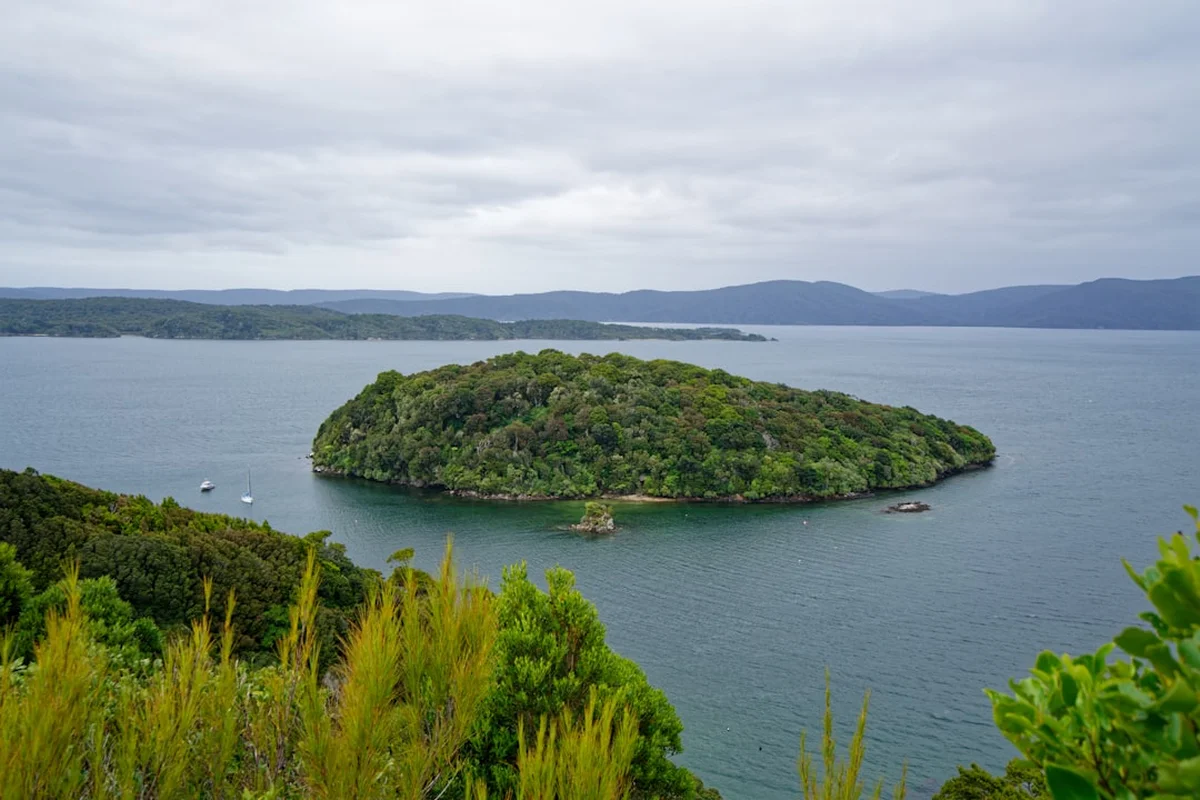
The Rakiura Track is a masterclass in coastal and forest ecology, providing a comprehensive overview of Stewart Island's natural heritage. The route is roughly divided into three distinct phases: the coastal northern section, the forested interior, and the sheltered western arm of Paterson Inlet/Whaka a Te Wera. While the total elevation gain is modest at approximately 450 metres, the terrain is undulating, and the track surface is famous for its "Rakiura mud"—a thick, peat-based sludge that can challenge even the most experienced walkers after heavy rain. However, recent track upgrades by the Department of Conservation (DOC) have significantly improved the most vulnerable sections with boardwalks and gravel, making the journey far more manageable than in decades past.
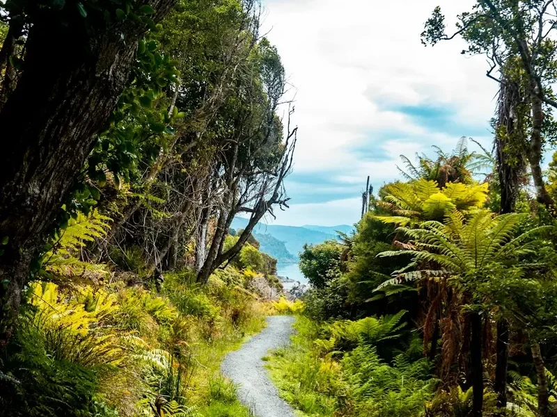
The coastal sections are arguably the highlight for many, featuring golden sand beaches like Māori Beach and Port William. These areas are not just scenic; they are geological windows into the island's past, where ancient granite headlands meet the relentless Southern Ocean. The interior forest is a dense tapestry of podocarps, including massive rimu, miro, and totara trees, draped in epiphytic ferns and mosses. The air here is thick with the scent of damp earth and salt, and the soundscape is dominated by the melodic calls of tui, bellbirds (korimako), and the occasional screech of the kaka (forest parrot).
One of the most compelling aspects of the Rakiura Track is its accessibility. Starting and ending near the small township of Oban (the only permanent settlement on the island), it allows walkers to experience true wilderness without the need for complex mountain logistics. Yet, once you pass the "Chain" sculpture at Lee Bay—symbolising the anchor stone of Maui’s canoe—the modern world falls away. The track offers a rare opportunity to slow down, to watch the tide come in over historical sawmill remains, and to sit quietly in a hut listening for the distinctive whistle of a kiwi in the darkness. It is a walk that rewards patience and observation as much as physical endurance.
History and Cultural Context
The cultural history of Rakiura is as deep and layered as its forests. For Māori, specifically the Ngāi Tahu iwi, the island is known as Te Punga o Te Waka a Māui (The Anchor Stone of Maui’s Canoe). According to legend, Stewart Island is the anchor that held Maui’s great canoe (the South Island) steady while he fished up the North Island. This spiritual connection remains vital today, and the island continues to be a significant site for the gathering of tītī (muttonbirds), a practice protected by treaty and tradition.
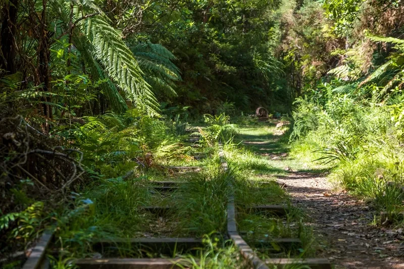
European history on the island began in the early 19th century with sealers and whalers, followed by a brief but intense period of timber milling and gold prospecting. The Rakiura Track passes directly through several of these historical sites. At Māori Beach, walkers can see the rusting remains of a steam boiler and other machinery from a sawmill that operated until the 1930s. These relics, slowly being reclaimed by the forest, serve as a poignant reminder of the island's industrial past and the resilience of nature. Port William was also the site of an ill-fated settlement scheme in the 1870s, where immigrants from the Shetland Islands attempted to establish a fishing community, only to be defeated by the isolation and harsh conditions.
The creation of the Rakiura National Park in 2002, covering about 85% of the island, marked a turning point in the island's history, shifting the focus from extraction to conservation. The Rakiura Track was established to allow people to experience this heritage while protecting the fragile ecosystem. Today, the track is managed with a deep respect for both its Māori roots and its colonial history, ensuring that every walker understands they are travelling through a landscape that has sustained people for centuries.
Want more background? Read extended notes on history and cultural context → Learn more
Seasonal Highlights and Weather Reality
Stewart Island lies in the path of the "Roaring Forties," meaning weather is the primary architect of any Rakiura adventure. The climate is maritime and temperate, but it is also highly unpredictable. It is not uncommon to experience bright sunshine, driving rain, and hail all within a single afternoon. However, the island rarely experiences the extreme temperature drops found in the Southern Alps, making it a viable year-round destination for well-prepared walkers.
Summer (December to February): This is the most popular time to walk. Days are long, with twilight lasting until nearly 10:00 PM, providing ample time for evening kiwi spotting. Temperatures typically range from 12°C to 20°C. While this is the "driest" season, rain is still frequent, and the mud can persist in shaded forest sections. This is also the peak season for sandflies, particularly near the coast.
Autumn (March to May): Many locals consider this the best time to be on the island. The weather often settles into a pattern of crisp, clear days and calm seas. The forest takes on a different hue, and the birdlife remains active. Night skies become darker earlier, increasing the chances of seeing the Aurora Australis if solar activity is high.
Winter (June to August): Winter on the Rakiura Track is for those seeking absolute solitude. While the track can be very muddy and the days are short, the forest remains lush and green. Snow is rare at sea level but can occur on the higher ridges. Huts are quieter, but walkers must be prepared for damp conditions and temperatures hovering between 4°C and 10°C. Proper waterproof gear is non-negotiable.
Spring (September to November): The forest erupts with new growth, and the bird song is at its most intense during the breeding season. However, spring is often the windiest and wettest time of year. The track can be particularly challenging during this period due to increased mud levels, but the vibrancy of the ecosystem is a significant reward.
Recommended Itinerary
3-Day Rakiura Track Itinerary (Clockwise)
Day 1: Lee Bay to Port William Hut/Campsite
- Distance: 8.1 km
- Elevation gain: 150 m
- Time: 3–4 hours
- Start at the Lee Bay car park, passing through the iconic "Chain" sculpture.
- Follow the coastal track with stunning views over Foveaux Strait.
- Cross Māori Beach, a long crescent of golden sand.
- Explore the historical sawmill remains at the western end of Māori Beach.
- Climb over a small headland to reach Port William.
- Arrive at Port William Hut (24 bunks) or the adjacent campsite.
- Evening: Walk down to the Port William wharf for sunset or look for kiwi in the surrounding bush.
Day 2: Port William Hut to North Arm Hut/Campsite
- Distance: 13 km
- Elevation gain: 250 m
- Time: 6 hours
- This is the "forest day," moving inland away from the coast.
- The track climbs steadily into the heart of the podocarp forest.
- Traverse sections of ancient rimu and miro forest.
- Expect the most significant mud sections on this day, though boardwalks cover the worst areas.
- Pass through the highest point of the track (180 m) with occasional glimpses of Paterson Inlet.
- Descend toward the shores of North Arm, a sheltered branch of Paterson Inlet.
- Arrive at North Arm Hut (24 bunks) or the campsite, situated in a beautiful forest clearing near the water.
Day 3: North Arm Hut to Fern Gully Car Park (Oban)
- Distance: 11 km
- Elevation gain: 50 m
- Time: 4–4.5 hours
- The track follows the shoreline of Paterson Inlet, weaving in and out of small bays.
- Pass through lush coastal forest with many ferns and mosses.
- View historical sites related to early milling and farming in the inlet.
- The track eventually emerges at the Fern Gully car park, approximately 2 km from the centre of Oban.
- Walk or arrange a shuttle back to Oban for a celebratory meal at the South Sea Hotel.
- This final day is relatively flat and provides a gentle conclusion to the journey.
Important Notes:
- The track can be walked in reverse, but the clockwise direction is generally preferred for the sequence of views.
- If walking from Oban to Lee Bay (Day 1), add an extra 5 km (approx. 1 hour) to your journey.
- Hut and campsite bookings are mandatory year-round and should be made well in advance during summer.
- Water is available at huts but should be treated or boiled.
- Always check the latest track conditions at the Rakiura National Park Visitor Centre before starting.
Planning and Bookings
Book Your Trip
Everything you need to plan your journey
Accommodation
Find places to stay near Oban
Flights
Search flights to Oban
Essential Preparation
Planning for the Rakiura Track begins with logistics. Since Stewart Island is separated from the South Island by Foveaux Strait, you must first reach the island. Most walkers take the 1-hour express ferry from Bluff or a 20-minute scenic flight from Invercargill. Both options require advance booking, especially during the summer months. If taking the ferry, be aware that Foveaux Strait can be rough; those prone to sea sickness should prepare accordingly.
Once on the island, the township of Oban serves as your base. It is a small, friendly community with a well-stocked Four Square supermarket, several cafes, and the famous South Sea Hotel. It is highly recommended to spend at least one night in Oban before and after your hike to allow for weather delays and to soak in the island atmosphere. Fitness requirements are moderate; while the track isn't steep, the mud and undulating terrain require a reasonable level of stamina. Ensure you have broken-in waterproof boots and are comfortable carrying a multi-day pack.
Trail Accommodation
The Rakiura Track features two Department of Conservation (DOC) huts: Port William Hut and North Arm Hut. Each hut sleeps 24 people in communal bunkrooms. There are also designated campsites at both locations for those who prefer to carry a tent.
Hut Facilities:
- Bunk beds with mattresses (no bedding provided).
- Common area with tables and seating.
- Wood-burning heaters (firewood provided by DOC).
- Gas cookers (available during the Great Walks season, usually October to April).
- Cold running water from tanks (treatment recommended).
- Non-flush toilets located a short walk from the hut.
- Basic solar lighting in common areas.
What Huts Do NOT Provide:
- Food or snacks of any kind.
- Cooking pots, pans, plates, or cutlery.
- Sleeping bags or pillows.
- Showers or hot water.
- Electricity for charging devices.
- Rubbish bins (you must pack out all waste).
Campsite Facilities:
- Designated flat areas for tents.
- Access to a cooking shelter (bring your own stove).
- Access to water and toilets.
- Campers are NOT permitted to use the hut facilities (bunks or indoor cooking areas).
Required Gear
- Waterproof Boots: Essential. The mud on Rakiura is legendary. Boots should have good ankle support and a waterproof membrane (Gore-Tex or similar).
- Gaiters: Highly recommended to keep mud and debris out of your boots and to protect your trousers.
- Waterproof Jacket: A high-quality, breathable rain jacket with a hood is mandatory.
- Waterproof Overtrousers: Essential for the frequent rain showers.
- Pack: A 40–60L tramping pack with a waterproof liner or rain cover.
- Sleeping Bag: A 3-season sleeping bag is sufficient for most of the year.
- Clothing Layers: Merino or synthetic base layers, a warm fleece or down mid-layer, and quick-dry trekking trousers (avoid denim).
- Head Torch: With spare batteries for hut use and evening kiwi spotting.
- First Aid Kit: Including blister plasters, antiseptic, and any personal medications.
- Survival Kit: Including a whistle, emergency blanket, and a basic multi-tool.
What to Bring
- Food: All meals and snacks for 3 days. Lightweight, high-energy options like dehydrated meals, nuts, and chocolate are best.
- Cooking Equipment: A lightweight stove (if camping or walking off-season), fuel, matches/lighter, pot, and eating utensils.
- Water Treatment: Purification tablets or a filter. While hut water is generally safe, DOC recommends treatment.
- Toiletries: Toothbrush, biodegradable soap, and a small towel.
- Sun Protection: Sunscreen, sunglasses, and a hat. The southern sun is surprisingly strong.
- Insect Repellent: Strong repellent (DEET-based) to ward off the persistent sandflies.
- Rubbish Bags: To pack out every single item of waste you produce.
- Personal Locator Beacon (PLB): Highly recommended. These can be hired from the Rakiura National Park Visitor Centre in Oban.
Permits

To walk the Rakiura Track, you must book your hut or campsite stays through the Department of Conservation (DOC) Great Walks booking system. There is no "permit" required to simply walk the track as a day visitor, but staying overnight without a booking is strictly prohibited and monitored by rangers.
Booking Process:
- Bookings typically open in May or June for the following season (July to June).
- During the peak summer months (December to February), huts can sell out weeks or even months in advance.
- You must select specific dates for each hut or campsite.
- Payment is required at the time of booking via the DOC website.
- Print your booking confirmation or have it available on your mobile device to show the hut warden.
Costs (Subject to Change):
- Huts: Approximately NZ$37 per night for NZ residents; NZ$56 for international visitors.
- Campsites: Approximately NZ$6 per night for NZ residents; NZ$9 for international visitors.
- Children (under 18) often stay for free or at a reduced rate, but a booking is still required.
Check-in: Before starting your walk, it is good practice to visit the Rakiura National Park Visitor Centre in Oban. They can provide the latest weather forecasts, track conditions, and any safety alerts. You do not need to "validate" your permit here, but it is the best place for last-minute information.
Other Activities in the Area
Stewart Island is a destination in its own right, and there is much to see beyond the Rakiura Track. Consider adding a few days to your itinerary to explore these options:
- Ulva Island (Te Wharawhara): A short water taxi ride from Golden Bay, this predator-free sanctuary is one of the best places in New Zealand to see rare birds like the South Island saddleback (tieke), yellowhead (mohua), and rifleman (titipounamu). The walking tracks are easy and well-maintained.
- Kiwi Spotting Tours: While you can look for kiwi on your own, guided evening tours significantly increase your chances of seeing these shy, nocturnal birds. Guides know the best spots and use red-light torches to avoid disturbing the birds.
- Sea Kayaking: Explore the sheltered waters of Paterson Inlet by kayak. This allows you to reach hidden coves and beaches that are inaccessible by foot.
- Fishing: Stewart Island is famous for its blue cod. Several charter boats operate out of Oban, offering half-day or full-day fishing trips.
- Village Walks: There are numerous shorter tracks around Oban, such as the walk to Observation Rock for panoramic views of Paterson Inlet, or the track to Ackers Point Lighthouse.
- Dining at the South Sea Hotel: No trip to Rakiura is complete without a meal at the local pub. It is the social heart of the island and serves excellent local seafood.
Safety and Conditions
While the Rakiura Track is not an alpine route, it presents its own set of safety challenges that should not be underestimated. The primary risks are related to weather, terrain, and isolation.
Weather Awareness: The weather can change with extreme rapidity. Hypothermia is a genuine risk even in summer if you become wet and the wind picks up. Always carry high-quality waterproof layers and a warm hat and gloves, regardless of the forecast. Check the MetService mountain forecast specifically for Stewart Island before you set off.
Track Conditions: The "Rakiura mud" can be more than just an inconvenience; it can be deep enough to pull off a boot or cause a fall. Take your time in muddy sections and use trekking poles for stability. Be aware that some coastal sections can be affected by exceptionally high tides or storm surges, though the main track is generally well above the high-water mark.
Communication: Cell phone coverage is non-existent once you leave the immediate vicinity of Oban. Do not rely on your phone for emergencies. Carrying a Personal Locator Beacon (PLB) is the only reliable way to signal for help. Ensure you leave your intentions with a trusted contact or use the DOC intentions system.
Water Safety: While the streams on the island look pristine, they can carry Giardia or other contaminants. Always treat water from huts or streams by boiling, filtering, or using chemical drops.
Sandflies: While not a direct safety threat, sandflies can cause significant distress and allergic reactions in some people. Use a strong repellent and keep your skin covered during breaks, especially near water.
Side Trips and Points of Interest
The Rakiura Track is rich with small details and historical markers that are worth a pause:
The Lee Bay Chain Sculpture: Located at the very start of the track, this massive sculpture by Russell Beck represents the anchor chain of Maui’s canoe. A matching sculpture exists at Tiwai Point near Bluff, symbolically linking the island to the mainland.
Māori Beach Sawmill: Take the time to explore the area just behind the beach. The rusting steam boiler and the remains of the old tramline are fascinating relics of the 1913–1931 milling era. It is a hauntingly beautiful spot where the forest is slowly reclaiming the machinery.
Port William Wharf: A great spot for a swim in the bracing southern waters or for a bit of evening fishing. It also offers a fantastic vantage point for looking back at the coastline you’ve just traversed.
Deadman Beach: A small, secluded bay between Māori Beach and Port William. It is a peaceful spot for a break and often has interesting driftwood and shells washed up after a storm.
Kiwi Spotting at North Arm: The area around the North Arm Hut is known for its high density of kiwi. If you are quiet and use a red-filtered torch, you may hear them rustling in the ferns or see them probing the ground for insects near the track.
Leave No Trace
Stewart Island is a fragile sanctuary, and walkers have a responsibility to minimise their impact. Following the Leave No Trace principles is essential for preserving the island's unique character for future generations.
Plan Ahead and Prepare: Ensure you have all the necessary gear and food so you don't have to rely on the environment. Check the weather and track conditions to avoid getting into situations where you might need to damage vegetation for shelter.
Travel and Camp on Durable Surfaces: Stay on the formed track at all times. Stepping off the track to avoid mud only widens the path and damages sensitive forest floor plants. Only camp in designated campsites.
Dispose of Waste Properly: "Pack it in, pack it out." This includes all food scraps, tea bags, and even biodegradable items like orange peels, which take a long time to decompose in this climate. Use the provided toilets at huts and campsites.
Leave What You Find: Do not remove plants, stones, or historical artefacts. The sawmill remains at Māori Beach are protected heritage sites; leave them exactly as you found them.
Minimise Campfire Impacts: Campfires are strictly prohibited on the Rakiura Track. Use a portable stove for all cooking.
Respect Wildlife: Stewart Island is a haven for birds. Never feed them, as this can make them dependent on humans or ill. Keep a respectful distance from kiwi and other nesting birds. If you see a sea lion on the beach, give it at least 20 metres of space.
Be Considerate of Others: Keep noise levels down in the huts and on the track. Many people come to Rakiura for the silence and the sounds of nature.