Quiraing Circuit - The Supernatural Heart of Skye
The Quiraing Circuit is arguably the most spectacular day walk in the United Kingdom—a 6.8 km loop that traverses the heart of the Trotternish Landslip on the Isle of Skye, Scotland. This is not merely a hike; it is a journey through a geological masterpiece where the earth has literally slipped and slid to create a landscape of impossible pinnacles, hidden plateaus, and sheer cliffs. Located on the northernmost peninsula of the island, the Quiraing is part of the largest landslip in Britain, stretching over 30 kilometres from the Old Man of Storr to the cliffs of Flodigarry. The circuit offers a concentrated experience of this ancient upheaval, leading walkers through a labyrinth of rock formations that feel more like the set of a high-fantasy epic than a Scottish hillside. With views stretching across the Sound of Raasay to the mountains of Wester Ross on the mainland, the Quiraing provides a sensory overload of scale, colour, and dramatic verticality.
- Distance: 6.8 km loop
- Duration: 3–5 hours
- Elevation Gain: 371 m
- Difficulty: Moderate (requires steady footing and a head for heights)
- Best Time: April to September (avoiding the worst of the winter gales and low cloud)
- Closest City: Portree (approx. 35 minutes drive)
- Trailhead: Quiraing Car Park, off the A855 between Staffin and Uig
- Terrain: Narrow mountain paths, rocky scrambles, and grassy ridge-lines
Overview
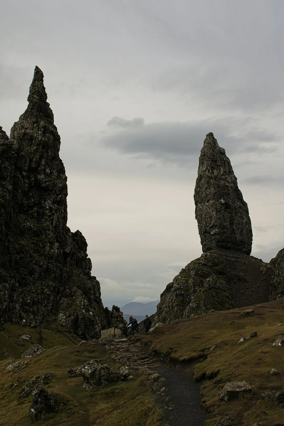
The Quiraing is a landscape in motion. Geologically, it is a massive landslip caused by the weight of heavy Tertiary basalt lavas (approximately 175 metres thick) overloading the weaker Jurassic sedimentary rocks beneath. Over millennia, the softer rocks have buckled and slid, causing the basalt above to fracture and slump toward the sea. This process continues today, albeit at a glacial pace, requiring the road at the base of the cliffs to be repaired almost annually. For the walker, this geological instability has resulted in a series of iconic features: The Needle, a 37-metre-high jagged rock pinnacle; The Prison, a massive block of basalt that, from certain angles, resembles a medieval fortress; and The Table, a flat, grassy plateau hidden high among the peaks, famously used by locals in centuries past to hide cattle from Viking raiders.
The walk is traditionally completed in a clockwise direction, beginning with a high-level traverse along the base of the cliffs before ascending to the ridge for a return journey that offers a bird's-eye view of the formations. The path is often narrow and hugs the side of steep slopes, which can be intimidating for those prone to vertigo, especially in high winds. However, the technical difficulty is relatively low for experienced hillwalkers. The real challenge lies in the Scottish weather; the Quiraing is notorious for "haar" (sea mist) that can roll in from the Atlantic in minutes, reducing visibility to a few metres and turning the dramatic landscape into a disorienting grey void. When the skies are clear, however, the contrast between the emerald green of the grass, the dark grey of the basalt, and the deep blue of the sea is nothing short of breathtaking.
Unlike many popular trails that have been sanitised for mass tourism, the Quiraing remains a raw, elemental experience. There are no fences, few signposts, and the path is often a simple trodden line through the scree. This lack of infrastructure preserves the sense of adventure, but it also demands respect. The Quiraing is a place where the scale of nature is humbling, and the silence—broken only by the cry of a raven or the whistling of the wind through the pinnacles—is profound. It is a quintessential Skye experience, distilling the island's reputation for wild, untamed beauty into a single, manageable afternoon.
History and Cultural Context
The name "Quiraing" is derived from the Old Norse 'Kví Rand', which translates roughly to "Fold of the Round Hill". This linguistic heritage is a reminder of the Viking influence that dominated the Hebrides for centuries. The Isle of Skye, and the Trotternish peninsula in particular, was a strategic stronghold for Norse settlers, and many of the local landmarks bear names that reflect this history. The Quiraing's unique topography provided more than just aesthetic wonder; it was a functional landscape for the people of Skye. The hidden plateaus and deep gullies served as natural fortifications and hiding places during times of clan warfare and Viking raids. The Table, a perfectly flat, lush meadow tucked away behind the pinnacles, is said to have been used to graze cattle where they could not be seen from the sea or the glens below.
In the 18th and 19th centuries, the Quiraing became a focal point for early Victorian travellers and geologists who were beginning to explore the "sublime" landscapes of the Scottish Highlands. Writers and artists were drawn to its jagged silhouettes, often imbuing the rock formations with romantic or gothic significance. The names "The Needle", "The Prison", and "The Table" date back to this era of early tourism, reflecting the Victorian penchant for naming natural features after architectural or domestic objects. Despite this early interest, the Quiraing remained relatively isolated until the mid-20th century, when improved road access made it a staple of the Skye tourist itinerary.
Today, the Quiraing is part of the Kilmuir Estate, which is owned by the Scottish Government and managed as a crofting estate. This means the land is still actively used for sheep farming, and walkers will frequently encounter hardy Scottish Blackface sheep grazing on the steep slopes. The cultural landscape of the Quiraing is therefore one of continuity—a place where ancient geology, Viking history, and modern Highland life intersect. It is also a site of significant scientific interest, providing geologists with a living laboratory to study the mechanics of large-scale landslips and the erosion of volcanic landscapes.
Want more background? Read extended notes on history and cultural context → Learn more
Seasonal Highlights and Weather Reality
The Quiraing is a year-round destination, but the experience changes dramatically with the seasons. Because of its northern latitude and exposure to the Atlantic, the weather is the primary factor in determining the safety and enjoyment of the walk. In Scotland, it is often said that you can experience four seasons in a single day, and nowhere is this more true than on the Trotternish Ridge.
Spring (April to June): This is often considered the best time to visit. The days are lengthening, the weather is generally drier than in autumn, and the "midge" (the infamous biting Highland gnat) has not yet emerged in force. The grass begins to turn a vibrant green, and the air is often exceptionally clear, providing the best views of the mainland mountains. However, late snow can still linger on the higher parts of the ridge, and the wind can remain biting.
Summer (July to August): This is peak tourist season. The weather is at its warmest (averaging 15–18°C), but this is also the wettest time of year in terms of humidity and sudden showers. The main challenge in summer is the crowds; the car park often fills by 9:00 AM, and the narrow paths can become congested. This is also the height of midge season; while the wind on the Quiraing usually keeps them at bay, they can be a nuisance in the car park or during calm spells.
Autumn (September to October): As the heather turns purple and the grasses fade to gold and rust, the Quiraing takes on a moody, atmospheric quality. The light is softer, making it a favourite time for photographers. The weather becomes more unpredictable, with stronger gales and more frequent rain, but the crowds thin out significantly. September is often a "sweet spot" before the winter weather truly sets in.
Winter (November to March): The Quiraing in winter is a serious undertaking. The path can be covered in ice or deep snow, making the narrow traverses extremely dangerous without crampons and an ice axe. Low cloud and short daylight hours (the sun sets as early as 3:30 PM in December) increase the risk of disorientation. However, on a rare crisp, clear winter day, the snow-dusted pinnacles against a pale blue sky offer a scene of unparalleled beauty. Only experienced winter hillwalkers should attempt the circuit during these months.
Recommended Itinerary
Quiraing Circuit Route Progression
Early Morning: Arrival and Initial Ascent
- Start at the Quiraing Car Park (high point of the road between Staffin and Uig).
- Follow the well-worn path heading north from the car park, keeping the high cliffs on your left.
- The first kilometre is relatively flat but narrow, traversing the steep grassy slopes of Meall na Suiramach.
- Pass through a small gate and cross a minor rockfall area where the path becomes slightly more rugged.
- Enjoy the immediate views of the "Prison" formation rising to your right.
Mid-Morning: The Heart of the Landslip
- Reach the base of "The Needle", the iconic 37-metre rock spire. This is the most photographed spot on the trail.
- The path weaves between massive blocks of fallen basalt, creating a labyrinthine feel.
- Look up to your left to see the hidden entrance to "The Table"—a steep scramble is required if you wish to visit it (see Extras).
- Continue northwards as the path levels out, passing through a dramatic gap between the main cliff and the "Prison".
- The terrain here is often boggy, even in dry weather, as water drains from the cliffs above.
Midday: The Northern Turn and Ascent
- The path eventually reaches a wire fence and a stile near the northern end of the landslip.
- Instead of continuing toward Flodigarry, turn sharp left and begin the steep ascent toward the ridge.
- This is the most physically demanding part of the walk, gaining approximately 150 metres of elevation in a short distance.
- The path can be slippery and eroded; take your time and use trekking poles if available.
- Once you reach the top of the ridge, the views open up 360 degrees, revealing the Atlantic to the west.
Afternoon: The Ridge Return
- Follow the ridge-line south, heading back toward the car park.
- The path here is much wider and easier to follow, though it remains close to the cliff edge in places.
- Pass the summit of Meall na Suiramach (543 m), the highest point of the walk.
- From this vantage point, you can look down onto the Needle and the Table, gaining a true sense of the landslip's scale.
- The descent back to the car park is steady and offers constant views of the Sound of Raasay and the Torridon hills in the distance.
- Arrive back at the trailhead for a total time of 3–4 hours depending on stops.
Important Notes:
- The circuit is best done clockwise to get the steep ascent out of the way and enjoy the ridge views on the return.
- In high winds, the ridge section can be dangerous; consider returning via the lower path if conditions deteriorate.
- The path is not waymarked; while the main track is obvious in clear weather, a map and compass are essential for mist.
- Allow extra time for photography—the light changes constantly and you will want to stop frequently.
Planning and Bookings
Book Your Trip
Everything you need to plan your journey
Accommodation
Find places to stay near Portree
Flights
Search flights to Portree
Essential Preparation
The Quiraing is a popular day walk, but its location on the Isle of Skye requires careful logistical planning. Portree is the main hub for the island and serves as the best base for the walk. From Portree, the drive to the trailhead takes approximately 35 minutes via the A855. The road is mostly single-track with passing places, which can be challenging for those unfamiliar with Highland driving. During the peak summer months, the car park at the Quiraing fills up very early (often by 9:00 AM). If the car park is full, do not park on the verges of the narrow road, as this blocks emergency vehicles and local farmers; instead, wait for a spot or try again later in the afternoon.
Fitness requirements are moderate. While the distance is short (6.8 km), the terrain is uneven and the ascent to the ridge is steep. Walkers should be comfortable with narrow paths and some minor rock stepping. There are no facilities (toilets, water, or food) at the trailhead or on the circuit, so you must be entirely self-sufficient. Ensure your vehicle has enough fuel, as the nearest petrol stations are in Portree or Uig, and mobile phone signal is intermittent at best throughout the Trotternish peninsula.
Trail Accommodation
This is a day hike requiring no overnight accommodation on the trail itself. Camping is technically permitted under Scotland's "Right to Roam" laws (Scottish Outdoor Access Code), but the Quiraing is a very exposed and fragile environment. Wild camping is discouraged within the immediate landslip area to prevent erosion and disturbance to livestock. Instead, walkers should look for accommodation in the surrounding villages:
- Staffin (10 mins drive): Offers several B&Bs, a small campsite, and self-catering cottages. This is the closest village to the trail.
- Uig (15 mins drive): A larger village with a hotel, youth hostel, and campsite. It is also the ferry terminal for the Outer Hebrides.
- Portree (35 mins drive): The island's capital with the widest range of hotels, hostels, and guesthouses. Booking months in advance is essential for summer visits.
- Flodigarry (10 mins drive): Home to a historic hotel and a hostel, located at the northern end of the Trotternish Ridge.
Required Gear
- Hiking Boots: Essential. The path is rocky, boggy, and uneven. Trainers do not provide enough ankle support or grip for the steep sections.
- Waterproof Jacket: Non-negotiable in Scotland. Even on a sunny day, a sudden Atlantic squall can arrive without warning. Gore-Tex or similar breathable fabric is recommended.
- Waterproof Overtrousers: Highly recommended, as the wind often blows rain sideways, making umbrellas useless.
- Layered Clothing: Use a moisture-wicking base layer, a warm fleece or wool mid-layer, and your waterproof shell. Avoid denim, which becomes heavy and cold when wet.
- Navigation: An OS Landranger map (Sheet 23) or Explorer map (Sheet 408), and a compass. Do not rely solely on smartphone GPS, as batteries drain quickly in the cold and signal is poor.
- Small Rucksack: 20–30 litres to carry your gear, food, and water.
- Trekking Poles: Very helpful for the steep ascent to the ridge and for stability on the narrow, sloping sections of the lower path.
What to Bring
- Water: At least 1.5–2 litres per person. There are no reliable treated water sources on the trail. While there are streams, they often run through sheep grazing land and should be filtered or treated before drinking.
- Food: High-energy snacks (nuts, chocolate, dried fruit) and a packed lunch. There are no cafés at the trailhead.
- Midge Repellent: Essential from June to September. Look for brands containing Smidge or DEET. A midge head-net is a lightweight and effective backup.
- Sun Protection: Sunscreen and sunglasses. The wind can mask the strength of the sun, leading to unexpected sunburn.
- First Aid Kit: Basic supplies including blister plasters (Compeed), antiseptic wipes, and any personal medications.
- Whistle and Torch: Standard safety gear for Scottish hills in case of an emergency or if you are delayed until after dark.
- Fully Charged Phone: For emergencies, though you should keep it in airplane mode to save battery.
Permits
No permits are required to walk the Quiraing Circuit. Under the Land Reform (Scotland) Act 2003, the public has a "Right to Roam" on most land in Scotland, provided they act responsibly. This means you are free to hike, take photographs, and explore the landscape without seeking formal permission or paying an entry fee.
Parking Fees: While the walk is free, the car park at the trailhead is managed by the Highland Council and is a "Pay and Display" site. As of 2024, the charges are approximately £3 for 3 hours or £5 for 6 hours. The machines accept coins and card payments, but the card system often fails due to poor signal, so carrying exact change in coins is highly recommended. The revenue from the car park is used to maintain the local road infrastructure and the trail itself.
Group Access: If you are organising a large commercial group (e.g., a guided tour or a charity event), it is polite to contact the Kilmuir Estate or the local community council in Staffin to ensure your visit does not conflict with local farming activities or other events. For individual walkers and small groups of friends, no such notification is necessary.
Drone Usage: The Quiraing is a popular spot for drone photography. However, you must comply with UK Civil Aviation Authority (CAA) regulations. Additionally, be mindful that the Quiraing is a working sheep farm; drones can easily spook livestock, especially during lambing season (April–May). Always keep your drone a respectful distance from animals and other walkers.
Other Activities in the Area
The Trotternish peninsula is packed with geological and cultural sites that can be combined with a visit to the Quiraing:
- Old Man of Storr: Another iconic landslip formation located 20 minutes south. It features a massive basalt pinnacle that can be seen for miles. The hike to the base is shorter but steeper than the Quiraing.
- Kilt Rock and Mealt Falls: A viewpoint on the coast where basalt columns (resembling the pleats of a kilt) drop 55 metres into the sea, accompanied by a spectacular waterfall.
- The Fairy Glen: Located near Uig, this is a miniature version of the Quiraing's landslip landscape, featuring small conical hills and a lochan. It has a whimsical, magical atmosphere.
- Staffin Dinosaur Footprints: At low tide, you can see 165-million-year-old dinosaur tracks embedded in the rocks at An Corran beach in Staffin.
- Skye Museum of Island Life: Located at Kilmuir, this museum features a group of traditional thatched croft houses, offering a glimpse into how people lived on Skye in the 19th century.
- Brother’s Point (Rubha nam Brathairean): A less-visited but equally dramatic headland offering great views and more dinosaur footprints.
Safety and Conditions
Weather Awareness: The single greatest danger at the Quiraing is the weather. Low cloud can descend rapidly, making navigation extremely difficult. If the mist comes in, stay on the main path; if you lose the path, use your compass to head west toward the ridge or east toward the road. Do not attempt to descend the cliffs in the mist. High winds are also common; on the ridge, gusts can be strong enough to knock a person off their feet. If the wind is gusting above 50 km/h, it is safer to stick to the lower path and avoid the ridge return.
Terrain Hazards: The path is narrow and often slopes toward steep drops. In wet weather, the basalt rock and the grassy slopes become incredibly slippery. There is one section on the lower path known as the "Bad Step"—a short, rocky scramble that can be tricky when wet. Take your time and ensure you have three points of contact. The ridge section has several "false edges" where the ground may be undercut; always stay at least two metres back from the cliff edge.
Livestock: You will be walking through active sheep grazing land. While the sheep are generally shy, they can be startled. If you are walking with a dog, it must be kept on a short lead at all times. Farmers are legally entitled to protect their livestock, and sheep being chased can fall from the cliffs. During lambing season (April and May), be extra cautious and give the animals plenty of space.
Emergency Procedures: In the event of an accident, dial 999 or 112 and ask for "Police" and then "Mountain Rescue". Be prepared to give your location (using a grid reference or a "What3Words" address). Note that mobile signal is very poor in the gullies of the Quiraing; you may need to send someone to the ridge or the car park to get a signal.
Hydration and Exposure: Even in cool weather, the physical exertion and the wind can lead to dehydration and exhaustion. Conversely, if you are injured and unable to move, hypothermia can set in quickly, even in summer. Always carry an emergency whistle and a foil space blanket.
Side Trips and Points of Interest
The Table: This is the Quiraing's "hidden" gem. It is a large, flat, sunken grassy plateau completely surrounded by rock towers. To reach it, you must leave the main path near the Needle and scramble up a steep, loose gully. It is not for the faint-hearted or those without scrambling experience, but once inside, the sense of enclosure and peace is extraordinary. It feels like a secret garden in the middle of a mountain. Legend says it was used to hide cattle, and standing there, it is easy to see why—it is invisible from almost every other part of the trail.
The Prison: This massive block of rock sits to the right of the main path as you head north. From the car park, it looks like a pyramid, but from the side, it resembles the walls of a fortress. You can walk around the base of the Prison for a different perspective on the landslip. The gap between the Prison and the main cliff creates a natural wind tunnel that can be quite exhilarating on a breezy day.
Flodigarry Extension: If you find the 6.8 km circuit too short, you can continue north from the stile instead of turning up to the ridge. The path continues along the Trotternish Ridge all the way to Flodigarry (an additional 4 km one way). This section is much quieter and offers views of the northern tip of Skye and the distant Outer Hebrides. You would then need to return the same way or arrange a taxi from Flodigarry back to the Quiraing car park.
Meall na Suiramach Summit: While the circuit passes near the summit, a short 5-minute detour to the actual cairn at 543 metres is worth it for the highest perspective in the area. On a clear day, you can see the entire length of the Trotternish Ridge stretching south toward the Storr, and north toward the lighthouse at Rubha Hunish.
Leave No Trace
The Quiraing is a fragile environment under significant pressure from high visitor numbers. The thin soils and steep slopes are highly susceptible to erosion. By following the Leave No Trace principles, you help ensure that this landscape remains spectacular for future generations.
Protecting the Landscape:
- Stay on the Path: This is the most important rule at the Quiraing. "Social trails" (shortcuts) destroy the vegetation and lead to massive scars on the hillside that take decades to heal. Even if the path is muddy, walk through the mud rather than around it to avoid widening the trail.
- Carry Out All Litter: This includes "organic" waste like orange peels, banana skins, and tea bags. In the cold, acidic soil of the Highlands, these items do not decompose quickly and are an eyesore for others.
- Human Waste: There are no toilets. If you are caught short, ensure you are at least 30 metres from any water source and bury waste in a shallow hole. Carry out all toilet paper and sanitary products in a sealed bag.
- Respect Wildlife and Livestock: Observe sheep and birds from a distance. Do not feed any animals.
- Leave What You Find: Do not move rocks to build cairns or "fairy circles". These disturb the soil and can be misleading for navigation. Leave the rocks where they have fallen.
- Be Considerate: The Quiraing is a place of natural beauty. Avoid loud music and keep noise to a minimum so that everyone can enjoy the sounds of the wilderness.