
Quilotoa Loop - Andean Highlands Adventure
The Quilotoa Loop is a spectacular multi-day trek through the Ecuadorian Andes, renowned for its dramatic volcanic landscapes, vibrant indigenous culture, and the breathtaking turquoise crater lake of Quilotoa. This is not a single, clearly defined trail but rather a network of routes connecting traditional Andean villages, passing through rolling hills, terraced farmland, and high-altitude páramo. The journey offers an immersive experience into the heart of rural Ecuador, where daily life unfolds at a pace dictated by the seasons and ancient traditions. Walkers are rewarded with panoramic vistas, encounters with local communities, and the unforgettable sight of the Quilotoa crater lake, a jewel nestled within a dormant volcano.
- Distance: Approximately 35.0 km (variable depending on exact route)
- Duration: 3-4 days
- Season: June to September (dry season) is generally best for clearer skies and less rain, though the loop can be walked year-round with appropriate preparation.
- Accommodation: Basic hostels and homestays in villages along the route.
- Highest point: Quilotoa Crater Rim (approx. 3,914 m)
- Difficulty: Challenging due to altitude, steep ascents/descents, and variable trail conditions.
- Closest City: Latacunga
- Trailhead Access: Buses from Latacunga to various villages (Sigchos, Isinlivi, Chugchilán, Quilotoa).
Overview
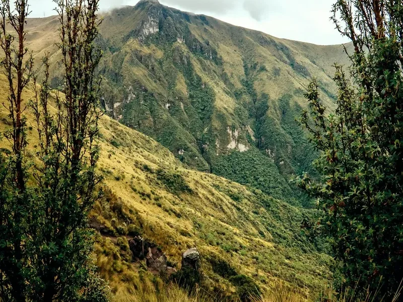
The Quilotoa Loop offers a captivating blend of natural beauty and cultural immersion. Unlike more formalised trails, it is a flexible route that can be adapted to individual preferences and fitness levels. The journey typically begins in the town of Latacunga, the gateway to the region, from where transport can be arranged to the starting village of choice, often Sigchos. From there, the path winds through a landscape of emerald green valleys, dotted with small farms and grazing llamas. The terrain is characterised by steep ascents and descents, testing the stamina of even seasoned hikers, particularly at altitudes that can exceed 3,500 metres.
The highlight for many is reaching the Quilotoa crater lake. This stunning natural wonder, with its impossibly vibrant turquoise waters, sits within the caldera of a dormant volcano. The views from the rim are simply breathtaking, offering a sense of profound peace and awe. The loop can be completed in various directions, but a common itinerary involves trekking from Sigchos to Isinlivi, then to Chugchilán, and finally to Quilotoa village, before returning to Latacunga. Each village offers a unique glimpse into Andean life, with opportunities to interact with local communities, sample traditional cuisine, and stay in simple, welcoming accommodations.
The weather in the Andes can be unpredictable, with sunshine, rain, and mist all possible within a single day. This variability adds to the adventure, creating dramatic shifts in light and atmosphere. The dry season from June to September generally offers more stable weather, making it the most popular time to visit. However, the loop is accessible year-round, and visiting during the shoulder seasons or even the wet season can offer a more solitary experience and dramatic, cloud-shrouded vistas.
History and Cultural Context
The Quilotoa Loop traverses a region steeped in history, deeply connected to the indigenous peoples who have inhabited the Ecuadorian Andes for millennia. This land was once part of the vast Inca Empire, and remnants of their presence can still be found in the terraced fields and ancient pathways that crisscross the landscape. The indigenous communities, primarily of Kichwa heritage, have maintained their cultural traditions, languages, and agricultural practices, offering a rich tapestry of human history woven into the natural environment.
The volcanic activity that shaped the region, culminating in the formation of the Quilotoa crater lake approximately 800 years ago, is a central element of the area's geological and cultural narrative. Local legends often speak of the volcano's power and the lake's mystical properties. The formation of the lake itself is a dramatic event; a massive eruption caused the summit to collapse, forming the caldera that now holds the stunning, mineral-rich waters.
In more recent history, the Quilotoa Loop has emerged as a popular trekking destination, attracting travellers seeking an authentic Andean experience away from the more tourist-heavy routes. The development of basic infrastructure, such as hostels and homestays in the villages, has made the loop more accessible while still preserving its rustic charm and cultural integrity. The communities along the loop have embraced tourism as a way to supplement their livelihoods, often offering homestays that provide invaluable insights into their daily lives, farming techniques, and cultural customs. This interaction is a cornerstone of the Quilotoa Loop experience, fostering mutual understanding and respect between visitors and locals.
Seasonal Highlights and Weather Reality
The Quilotoa Loop's climate is dictated by its high Andean altitude, resulting in two distinct seasons: the dry season and the wet season.
Dry Season (June to September): This period is characterised by cooler temperatures and significantly less rainfall. Days are often sunny and clear, offering excellent visibility for the stunning mountain panoramas and the vibrant colours of Quilotoa lake. Mornings can be crisp and cold, with temperatures often dropping below freezing at night, especially at higher elevations. This is the most popular time for trekking, as the trails are generally in better condition, and the risk of being caught in heavy downpours is lower. However, even in the dry season, sudden weather changes are common, and it's essential to be prepared for cooler temperatures and occasional rain showers.
Wet Season (October to May): During these months, rainfall is more frequent and intense, often occurring in the afternoons. The landscape becomes lush and green, and the waterfalls are at their most impressive. While the trails can become muddy and slippery, and visibility may be reduced by cloud cover, the wet season offers a more dramatic and atmospheric experience. The villages are less crowded, and the vibrant colours of the Andean flora are at their peak. Temperatures are generally milder than in the dry season, though still cool at night.
Shoulder Seasons (April-May and September-October): These transitional periods can offer a good balance, with fewer crowds than the peak dry season and a reduced chance of prolonged heavy rain compared to the wet season. Weather can be variable, but often provides a mix of sunny days and occasional showers.
Regardless of the season, it is crucial to be prepared for significant temperature fluctuations. The altitude means that even on a sunny day, temperatures can drop rapidly as the sun sets or if cloud cover rolls in. Layering clothing is essential for comfort and safety throughout the year.
Recommended Itinerary
3-Day Quilotoa Loop Itinerary (Classic Route)
Day 1: Sigchos to Isinlivi
- Distance: Approximately 12.0 km
- Elevation gain: ~500 m
- Elevation loss: ~700 m
- Time: 4–5 hours
- Start by taking a bus from Latacunga to Sigchos.
- Begin the trek from Sigchos, descending into the valley.
- The trail follows a scenic route through farmland and small hamlets.
- Cross the Toachi River via a suspension bridge.
- Ascend towards Isinlivi, a charming village known for its welcoming atmosphere.
- Accommodation: Hostal in Isinlivi.
- This day involves significant descent followed by a steady climb, offering a good introduction to the Andean terrain.
Day 2: Isinlivi to Chugchilán
- Distance: Approximately 14.0 km
- Elevation gain: ~600 m
- Elevation loss: ~500 m
- Time: 5–6 hours
- Depart Isinlivi, continuing through rolling hills and agricultural landscapes.
- The trail offers stunning views of the surrounding valleys and mountains.
- Pass through remote communities and observe traditional farming methods.
- The path can be steep in sections, requiring good stamina.
- Arrive in Chugchilán, a larger village with more accommodation options.
- OPTIONAL: Visit the Chugchilán cheese factory.
- Accommodation: Hostal or homestay in Chugchilán.
- This day is often considered one of the most scenic, with expansive views and a sense of remoteness.
Day 3: Chugchilán to Quilotoa Crater Lake and return to Latacunga
- Distance: Approximately 9.0 km to the crater rim
- Elevation gain: ~800 m
- Time: 3–4 hours to reach the rim
- Begin the trek from Chugchilán, heading towards the Quilotoa volcano.
- The ascent is steady and can be challenging due to the altitude.
- Reach the Quilotoa crater rim, offering breathtaking views of the turquoise lake below.
- Spend time exploring the rim, taking photographs, and enjoying the spectacular scenery.
- OPTIONAL: Descend to the lake shore (steep and demanding return).
- From Quilotoa village, catch a bus back to Latacunga.
- Accommodation: Not applicable for this day as it's a day hike to the lake and return.
- This is the most iconic day, culminating in the unforgettable sight of Quilotoa lake.
Alternative/Extended Itinerary (4 Days):
- Day 1: Latacunga to Sigchos (Bus transfer, explore Sigchos)
- Day 2: Sigchos to Isinlivi (As above)
- Day 3: Isinlivi to Chugchilán (As above)
- Day 4: Chugchilán to Quilotoa and return to Latacunga (As above)
Important Notes:
- This is a flexible route; exact distances and times can vary.
- Accommodation is basic but clean and welcoming. Book in advance during peak season.
- Altitude can affect performance; acclimatise properly in Latacunga or Quito before starting.
- Carry sufficient water and snacks, as services are limited between villages.
- Be prepared for all types of weather, even within a single day.
- Buses between villages can be infrequent; check schedules locally.
Planning and Bookings
Book Your Trip
Everything you need to plan your journey
Accommodation
Find places to stay near Latacunga
Flights
Search flights to Latacunga
Essential Preparation
The Quilotoa Loop is an adventure that requires careful planning, especially regarding logistics and acclimatisation. Latacunga is the primary hub for accessing the loop. It's advisable to spend at least one night here to acclimatise to the altitude (approx. 2,750 m) before commencing the trek. From Latacunga, local buses are the most common and economical way to reach the starting villages like Sigchos, Isinlivi, Chugchilán, and Quilotoa. These buses can be basic and schedules may vary, so flexibility is key. Road conditions can be rough, particularly to more remote villages.
Fitness is a crucial consideration. The loop involves significant elevation changes, steep ascents and descents, and walking at high altitudes. A good level of cardiovascular fitness and experience with multi-day hiking, especially in mountainous terrain, is recommended. It's wise to carry a basic first-aid kit and any personal medications. Informing your accommodation providers or a trusted contact of your daily itinerary is also a good safety practice.
Trail Accommodation
Accommodation along the Quilotoa Loop is generally simple and rustic, reflecting the rural nature of the region. The villages of Sigchos, Isinlivi, Chugchilán, and Quilotoa offer a range of options, primarily consisting of small hostels and homestays.
Hostels: These typically offer dormitory-style rooms with shared bathrooms, and sometimes private rooms. They often have communal areas where hikers can relax and socialise. Facilities usually include basic beds with mattresses, and sometimes a shared kitchen or dining area. Hot water can be intermittent.
Homestays: Staying with local families provides a unique cultural experience. You'll typically be offered a simple room in their home and often share meals with the family, providing an invaluable insight into daily Andean life. This is an excellent way to support local communities directly.
Booking Requirements: While it's often possible to find accommodation upon arrival, especially in the larger villages like Chugchilán, booking in advance is highly recommended, particularly during the dry season (June-September) and around public holidays. This ensures you secure a bed and helps the local providers plan.
Facilities Provided: Basic bedding (mattresses, sometimes blankets), communal dining areas, and often Wi-Fi (though it can be unreliable). Some places may offer hot meals for an additional cost.
What's NOT Provided: Towels, toiletries, cooking equipment (unless specified), heating (rooms can be cold), and electricity for charging devices may be limited or unavailable in some locations.
Seasonal Availability: Accommodation is generally available year-round, though services might be more limited in very remote areas during the wet season.
Costs: Expect to pay approximately US$10-25 per person per night for a bed in a hostel or a homestay, often including breakfast. Meals can cost an additional US$5-10.
Required Gear
- Sturdy hiking boots - waterproof and well broken-in, with good ankle support.
- Waterproof and windproof jacket - essential for unpredictable Andean weather.
- Waterproof overtrousers - to protect against rain and wind.
- Warm layers - including fleece or down jacket, thermal base layers (merino wool or synthetic).
- Hat and gloves - for warmth, especially at higher altitudes and during evenings.
- Backpack - 30-45 litre capacity, comfortable for multi-day trekking.
- Rain cover for backpack.
- Head torch or flashlight - with spare batteries, for early mornings or evenings.
- First-aid kit - including blister treatment, pain relievers, antiseptic wipes, bandages, and any personal medications.
- Sun protection - high SPF sunscreen, sunglasses, and a wide-brimmed hat.
- Water bottles or hydration reservoir - at least 2 litres capacity per person.
- Trekking poles - highly recommended for steep ascents and descents, and for stability on uneven terrain.
What to Bring
- Food and snacks - high-energy snacks like nuts, dried fruit, energy bars. While meals can be purchased, carrying your own is wise for longer stretches.
- Water purification tablets or filter - as a backup, though water in villages is generally potable.
- Toiletries - biodegradable soap, toothbrush, toothpaste, hand sanitiser.
- Quick-drying towel.
- Camera and spare batteries/power bank.
- Small notebook and pen - for journaling or noting down local phrases.
- Cash - US Dollars (Ecuador's currency) in small denominations for buses, accommodation, and meals. ATMs are scarce outside of Latacunga.
- Basic Spanish phrasebook or translation app - English is not widely spoken in rural areas.
- Plastic bags or dry bags - to keep gear dry and organised.
- Insect repellent - though generally not a major issue at these altitudes, it's good to have.
Permits
No specific permits are required to hike the Quilotoa Loop. The trails are generally open and accessible to all. However, there is a small entrance fee to access the Quilotoa crater lake itself, typically collected at the village of Quilotoa or designated viewpoints along the rim. This fee is usually nominal and contributes to the upkeep of the area and local community projects.
Quilotoa Crater Lake Entrance Fee:
- Approximately US$2 per person.
- This fee is usually paid in cash at the entrance to the viewpoint area or collected by local guides/officials.
- It is advisable to carry small US dollar bills for this purpose.
Other Considerations:
- Local Guides: While the loop can be navigated independently using maps and GPS, hiring a local guide is highly recommended, especially for first-time visitors or those less confident with navigation. Guides can enhance the cultural experience by providing insights into local customs, flora, and fauna, and can assist with logistics such as bus connections and accommodation.
- Community Contributions: In some villages, particularly those offering homestays, there might be implicit or explicit expectations of supporting local crafts or purchasing local produce. This is part of the cultural exchange and a way to directly benefit the communities you visit.
The absence of formal permits contributes to the loop's accessibility and its appeal as an uncommercialised trekking experience. The focus remains on the natural beauty and the cultural interactions, rather than bureaucratic processes.
Other Activities in the Area
Beyond the trek itself, the Quilotoa region offers several enriching activities:
- Exploring Quilotoa Village: Spend time in the village of Quilotoa, interacting with local artisans selling colourful textiles, woven goods, and traditional crafts. The market days can be particularly vibrant.
- Hiking around the Crater Rim: The full circuit around the Quilotoa crater rim is a challenging but rewarding hike, offering constantly changing perspectives of the lake and surrounding Andean landscape. This typically takes 3-4 hours.
- Descending to the Lake Shore: For the adventurous, a steep and demanding hike down to the edge of the Quilotoa lake is possible. The climb back up is strenuous, so only attempt this if you are fit and have ample time. Kayaks are sometimes available for rent on the lake.
- Visiting Local Markets: If your itinerary aligns, visiting the weekly markets in towns like Sigchos or Zumbahua can be a fascinating cultural experience, showcasing local produce, livestock, and traditional clothing.
- Cheese Tasting in Chugchilán: The village of Chugchilán is known for its artisanal cheese production. Visiting a local cheese factory for a tasting is a delightful culinary experience.
- Cultural Homestays: Opting for homestays in villages like Isinlivi or Chugchilán provides an unparalleled opportunity to immerse yourself in the daily lives of the Kichwa communities, learn about their traditions, and share meals.
- Photography: The dramatic landscapes, vibrant colours of the lake, and the rich cultural heritage offer endless opportunities for stunning photography.
Safety and Conditions
Altitude Sickness: The Quilotoa Loop reaches significant altitudes (up to 3,914 m at the crater rim). Altitude sickness (soroche) can affect anyone, regardless of fitness. Symptoms include headache, nausea, dizziness, and fatigue. To minimise risk:
- Acclimatise properly by spending at least 1-2 nights in Latacunga (2,750 m) or Quito (2,850 m) before starting the trek.
- Ascend gradually. The itinerary provided allows for this.
- Stay hydrated by drinking plenty of water.
- Avoid alcohol and heavy meals in the first few days at altitude.
- If symptoms worsen, descend immediately.
Trail Conditions: Trails can be steep, rocky, and uneven. During the wet season (October-May), paths can become muddy and slippery, increasing the risk of falls. Good quality hiking boots with ankle support are essential. Trekking poles are highly recommended for stability.
Weather: Andean weather is notoriously unpredictable. Be prepared for rapid changes, including sunshine, heavy rain, strong winds, and cold temperatures, even within the same day. Layering clothing is crucial. Always carry waterproofs and warm layers, even on seemingly clear days.
Navigation: While the main routes are generally well-trodden, the loop is not a formally marked trail in many sections. Using a GPS device or a reliable offline map app (like Maps.me or Gaia GPS) with downloaded maps is strongly advised. Hiring a local guide is the safest option for navigation, especially if you are unfamiliar with the area or if weather conditions are poor.
Communication: Mobile phone signal can be intermittent or non-existent in many parts of the loop, especially between villages. Inform someone of your itinerary and expected return time. Consider carrying a personal locator beacon (PLB) for emergencies.
Water and Food: While water is generally available in villages, it's advisable to treat all water from streams or natural sources. Carry sufficient snacks and food, as options can be limited between villages. Ensure you have enough cash, as ATMs are scarce outside of Latacunga.
Cultural Sensitivity: Always be respectful of local customs and traditions. Ask permission before taking photographs of people. Dress modestly when visiting villages or interacting with communities.
Emergency Services: Emergency services are limited in rural areas. In case of a serious emergency, you will likely need to rely on your guide or local contacts to arrange transport to the nearest medical facilities in Latacunga.
Side Trips and Points of Interest
Toachi River Canyon: On Day 1 of the classic itinerary, the trail descends into the Toachi River canyon. The crossing of the river, often via a suspension bridge, offers dramatic views of the gorge and the powerful river below. This section highlights the dramatic topography of the region.
Local Markets: If your timing is right, visiting a local market in one of the villages can be a highlight. The market in Sigchos, for instance, is a vibrant affair where local farmers and artisans gather to trade goods. These markets offer a fantastic opportunity to witness authentic Andean life and purchase local produce or crafts.
Chugchilán Cheese Factory: Chugchilán is renowned for its artisanal cheese production. A visit to a local cheese factory offers a chance to learn about the cheese-making process and sample delicious, locally produced cheeses. This is a unique culinary detour that adds flavour to the trekking experience.
Quilotoa Village and Artisan Stalls: The village of Quilotoa itself is a hub of activity, especially on market days. Local women often set up stalls selling colourful textiles, hand-knitted items, and traditional crafts. These items make excellent souvenirs and directly support the local economy.
The Quilotoa Crater Rim Walk: While the main itinerary reaches the rim, dedicating extra time to walk the full circuit around the crater offers unparalleled, ever-changing views of the lake and the surrounding volcanic landscape. This is a significant undertaking, requiring good fitness and several hours, but the panoramic vistas are extraordinary.
Descent to the Lake Shore: For the truly adventurous, the steep, winding path down to the very edge of the Quilotoa lake is an option. The vibrant turquoise water up close is mesmerising. However, the climb back up is extremely strenuous due to the steep gradient and altitude, so this detour should only be attempted by those with excellent fitness and sufficient time.
Leave No Trace
The Quilotoa Loop traverses a fragile Andean ecosystem and passes through communities that rely on the land for their livelihood. Practising Leave No Trace principles is paramount to preserving this beautiful region for future visitors and for the local people.
Plan Ahead and Prepare: Research the route, understand the conditions, and pack appropriately. Inform yourself about local customs and be prepared for varying weather. This includes carrying sufficient food and water, and having a plan for accommodation.
Travel and Camp on Durable Surfaces: Stick to established trails and paths. Avoid cutting switchbacks, as this causes erosion. When resting or taking breaks, choose a spot that is already bare or a well-used area to minimise impact on vegetation.
Dispose of Waste Properly: Pack out everything you pack in. This includes all food scraps, wrappers, and any other litter. Use designated toilet facilities in villages and hostels. If you must go in the backcountry, dig a cathole at least 60 metres (60 m) from water sources, trails, and campsites. Pack out all toilet paper.
Leave What You Find: Do not take rocks, plants, or cultural artefacts. Respect the natural and cultural heritage of the area. Observe wildlife from a distance and do not feed animals, as this can disrupt their natural behaviours and diets.
Minimise Campfire Impacts: Campfires are generally not feasible or appropriate on the Quilotoa Loop due to the lack of designated campsites and the prevalence of high winds. Use a portable stove for cooking.
Respect Wildlife: Observe animals from a distance and never feed them. Their natural behaviours can be disrupted by human interaction, and feeding them can lead to dependency or health problems.
Be Considerate of Other Visitors: Keep noise levels down, especially in villages and shared accommodation. Yield to other hikers on narrow trails. Respect the local culture and traditions; dress modestly and ask permission before taking photographs of people.
By adhering to these principles, you help ensure that the Quilotoa Loop remains a pristine and culturally rich destination.