Queulat Hanging Glacier Trail
The Queulat Hanging Glacier Trail is a captivating day walk located within the Queulat National Park in Chilean Patagonia. This trail offers a relatively accessible yet rewarding experience, leading hikers through dense Valdivian temperate rainforest to a breathtaking viewpoint of the Ventisquero Colgante (Hanging Glacier). The journey is a sensory immersion into the lush, damp environment characteristic of this region, with towering trees, abundant ferns, and the constant sound of water. The trail culminates in a dramatic vista of a glacier suspended precariously on a cliff face, a stark reminder of the powerful glacial forces that have shaped this landscape. It's a perfect introduction to the wild beauty of Chilean Patagonia for those seeking a moderate day hike with a spectacular payoff.
- Distance: 12.0 km return
- Duration: 4–5 hours
- Elevation Gain: 400 m
- Difficulty: Moderate
- Season: October to April (Chilean summer/shoulder seasons)
- Closest City: Coyhaique
- Trailhead Access: Route 7 (Carretera Austral) south of Puyuhuapi
- Parking: Available at trailhead
- Permits: Generally not required for day use, but check park regulations
Overview
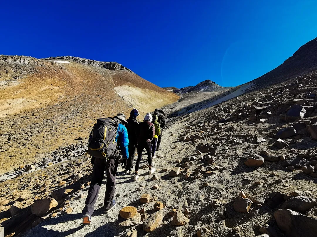
The Queulat Hanging Glacier Trail is a testament to the raw, untamed beauty of the Chilean Patagonia. This moderate day hike, approximately 12 kilometres in length with a significant elevation gain of 400 metres, is a journey into the heart of the Valdivian temperate rainforest. The trail begins at a relatively low elevation, gradually ascending through a dense, verdant environment. Hikers will traverse well-maintained paths, often boardwalks or gravel tracks, that wind through ancient trees draped in moss and lichen, with an understory thick with ferns and other moisture-loving plants. The air is perpetually humid, carrying the scent of damp earth and decaying leaves, a signature aroma of this unique ecosystem.
As the trail climbs, the forest canopy begins to thin, offering glimpses of the surrounding mountains and the dramatic glacial features that define the park. The sound of rushing water becomes increasingly prominent, hinting at the numerous streams and waterfalls that feed the glacier and carve their way down the mountainsides. The final ascent involves steeper sections, often with steps or rocky outcrops, leading to the main viewpoint. From this vantage point, the Queulat Hanging Glacier is revealed in all its glory. It appears to defy gravity, a massive body of ice clinging to a sheer rock face, with meltwater cascading over the edge to form spectacular waterfalls that plunge into the valley below. The contrast between the stark white ice and the vibrant green of the surrounding rainforest is striking.
The trail is well-marked and maintained by CONAF (Corporación Nacional Forestal), ensuring a safe and enjoyable experience for most hikers. However, the moderate difficulty rating is due to the sustained climb and the potential for slippery conditions, especially after rain. The best time to visit is during the Chilean summer and shoulder seasons (October to April) when the weather is generally more favourable, although rain is a common occurrence year-round in this region. The trail offers a profound connection with nature, showcasing the unique flora and fauna of the Valdivian rainforest and the awe-inspiring power of glacial landscapes.
History and Cultural Context
The Queulat National Park, and specifically the area around the Hanging Glacier, has a history intertwined with the exploration and settlement of Chilean Patagonia. For millennia, the indigenous peoples of this region, such as the Chono and Aonikenk, navigated these fjords and forests, utilising the abundant natural resources for survival. Their presence and deep understanding of the land are an integral part of the area's cultural heritage, though much of their history in this specific, remote region remains undocumented in written records.
European exploration of this rugged coastline began in earnest in the 18th and 19th centuries. The challenging terrain, dense forests, and unpredictable weather made access difficult, and the area remained largely uncharted for a long time. The Carretera Austral, a monumental road construction project initiated in the 1970s, was crucial in opening up this remote region to greater access and tourism. The road itself is a feat of engineering, carving its way through mountains and along fjords, connecting isolated communities and allowing for the development of national parks like Queulat.
The Queulat Hanging Glacier (Ventisquero Colgante) became a significant point of interest due to its dramatic and unusual formation. Its accessibility, relatively speaking, compared to other Patagonian glaciers, made it a focal point for early naturalists and explorers. The establishment of Queulat National Park in 1983 was a vital step in protecting this unique glacial and forest ecosystem from potential exploitation and ensuring its preservation for future generations. The trail itself was developed to allow visitors to experience the glacier's grandeur safely, reflecting a growing awareness of ecotourism and the importance of conservation in the region.
Seasonal Highlights and Weather Reality
The Queulat Hanging Glacier Trail is best experienced during the warmer months in Chile, which correspond to the Southern Hemisphere's spring, summer, and autumn. This period, from October to April, offers the highest probability of encountering more favourable weather conditions, although "favourable" in Patagonia is a relative term.
Spring (October–November): This is a time of renewal in the Valdivian rainforest. The vegetation begins to burst with new growth, and the forest floor may be carpeted with early wildflowers. The air is crisp, and while rain is still frequent, there's a sense of awakening after the winter. Snow may still be present at higher elevations, potentially affecting the upper sections of the trail, though the main trail is usually clear.
Summer (December–February): This is the peak tourist season. Days are longer, offering more daylight hours for hiking. The forest is at its most lush and vibrant. However, summer also brings the highest chance of rain and strong winds, characteristic of the Patagonian climate. Sandflies can also be present, though typically less aggressive than in some other parts of Patagonia. The glacier's meltwater is at its most active, making the waterfalls particularly impressive.
Autumn (March–April): The colours of the forest begin to change, with some deciduous trees offering a display of reds and yellows, though the dominant Valdivian rainforest is evergreen. The crowds thin out, offering a more tranquil experience. The weather can be unpredictable, with a mix of clear, crisp days and increasing chances of rain and colder temperatures as winter approaches. Snowfall becomes more likely at higher elevations towards the end of April.
Winter (May–September): This period is generally not recommended for hiking the Queulat Hanging Glacier Trail. The park experiences significant rainfall, strong winds, and potential snowfall, making the trail conditions hazardous and the glacier viewpoint often obscured by clouds or fog. Many facilities may be closed, and access roads could be affected by weather. While the landscape is undeniably dramatic in winter, it requires specialised winter hiking experience and equipment.
Regardless of the season, visitors should always be prepared for rapid weather changes. Patagonian weather is notoriously fickle, and it is not uncommon to experience sunshine, rain, wind, and fog all within a single day.
Recommended Itinerary

Queulat Hanging Glacier Trail - Day Walk Itinerary
Early Morning (Approx. 8:00 AM - 9:00 AM): Travel to Trailhead
- Depart from your accommodation in Puyuhuapi or a nearby town.
- Drive south on Route 7 (Carretera Austral) for approximately 50-60 km.
- The drive itself is scenic, offering views of fjords and mountains.
- Allow approximately 1-1.5 hours for the drive, depending on road conditions and starting point.
- Arrive at the well-marked entrance to Queulat National Park and the trailhead parking area.
Morning (Approx. 9:00 AM - 11:30 AM): Ascent Through Rainforest
- Begin the hike from the parking area.
- The initial section of the trail is relatively gentle, winding through dense Valdivian temperate rainforest.
- Experience the unique flora: ancient trees, abundant mosses, ferns, and epiphytes.
- Listen to the sounds of the forest and the increasing presence of water.
- The trail may include boardwalks over marshy areas and well-maintained gravel paths.
- Start the gradual ascent, gaining elevation steadily.
Midday (Approx. 11:30 AM - 1:00 PM): Reaching the Viewpoint
- The trail becomes steeper and more challenging as you approach the glacier.
- You may encounter sections with steps or rocky terrain.
- The forest canopy begins to open up, offering occasional views of the surrounding peaks.
- The sound of the glacier's meltwater becomes more pronounced.
- Arrive at the primary viewpoint for the Queulat Hanging Glacier.
- Spend time admiring the spectacular sight of the glacier clinging to the cliff face and the powerful waterfalls it creates.
- Take photographs and absorb the dramatic landscape.
Afternoon (Approx. 1:00 PM - 3:00 PM): Descent and Return
- Begin the descent back down the trail.
- The descent can be as challenging as the ascent, especially on wet surfaces.
- Take your time and use caution on steeper sections.
- Enjoy the rainforest environment from a different perspective on the way down.
- Return to the trailhead parking area.
Late Afternoon (Approx. 3:00 PM onwards): Departure
- Depart from the national park.
- Drive back towards Puyuhuapi or your next destination.
- Consider stopping at other viewpoints or points of interest along the Carretera Austral.
Important Notes:
- This is a day hike; no overnight accommodation is required on the trail.
- Carry sufficient water and snacks, as there are no facilities on the trail.
- Wear sturdy, waterproof hiking boots.
- Be prepared for rain at any time of year; waterproof clothing is essential.
- The trail can be slippery, especially after rain.
- Check park opening hours and any specific regulations with CONAF before your visit.
Planning and Bookings
Book Your Trip
Everything you need to plan your journey
Accommodation
Find places to stay near Coyhaique
Flights
Search flights to Coyhaique
Essential Preparation
The Queulat Hanging Glacier Trail is located within Queulat National Park, accessible via the Carretera Austral (Route 7). The closest significant town with services is Puyuhuapi, approximately 50-60 kilometres north of the park entrance. Coyhaique, a larger city, is about 220 kilometres south, making it a common starting point for exploring this section of the Carretera Austral. Visitors typically reach the trailhead by private vehicle (rental car or campervan) or by bus services that operate along the Carretera Austral, though schedules can be infrequent and require careful planning.
Given the remote location, it is crucial to have your transportation sorted in advance. Rental cars are available in Coyhaique and Puerto Montt. If travelling by bus, confirm schedules and book tickets ahead of time, especially during peak season. Ensure your vehicle is in good condition, as mechanical issues in remote areas can be problematic. Mobile phone reception is extremely limited or non-existent along much of the Carretera Austral and within the national park, so download offline maps and inform someone of your travel plans.
The best time to visit is during the Chilean summer and shoulder seasons (October to April) for more stable weather, though rain is always a possibility. Pack accordingly for all types of weather. Basic amenities like food and fuel are scarce between towns, so stock up in Puyuhuapi or Coyhaique before heading out.
Trail Accommodation
This is a day hike requiring no overnight accommodation on the trail itself. Queulat National Park is primarily visited for day excursions. However, accommodation is available in the surrounding areas:
- Puyuhuapi: Offers a range of options from hotels and guesthouses to cabins and hostels. It's the closest town with significant services.
- Coyhaique: A larger city further south, providing a wider array of accommodation, including hotels, hostels, and bed and breakfasts. It serves as a major hub for exploring the Aysén region.
- Camping: There are designated campsites within Queulat National Park and along the Carretera Austral, offering basic facilities. These are typically first-come, first-served.
Booking accommodation in advance is highly recommended, especially during the peak summer season (December to February), as options can fill up quickly.
Required Gear
- Waterproof Hiking Boots: Sturdy, waterproof boots with good ankle support are essential. The trail can be muddy and slippery, especially after rain. Ensure they are well broken-in to prevent blisters.
- Waterproof Jacket and Trousers: Essential for protection against the frequent rain and wind. Look for breathable, waterproof materials like Gore-Tex.
- Layered Clothing: Pack synthetic or merino wool base layers, an insulating mid-layer (fleece or down jacket), and an outer shell. Avoid cotton, as it retains moisture and takes a long time to dry.
- Backpack: A comfortable daypack (20-30 litres) to carry essentials. A rain cover for the backpack is advisable.
- Navigation: While the trail is generally well-marked, an offline map of the area and a compass or GPS device are recommended, especially given the limited mobile signal.
- First-Aid Kit: A basic kit including plasters, antiseptic wipes, pain relievers, blister treatment, and any personal medications.
- Head Torch: Useful in case of unexpected delays or if starting very early/finishing late, though daylight hours are long in summer.
- Sun Protection: Sunglasses, sunscreen, and a hat are still important, as the sun can be intense even on cloudy days, especially at higher elevations.
What to Bring
- Food and Snacks: Pack plenty of high-energy snacks (nuts, dried fruit, energy bars) and a packed lunch. There are no food services on the trail.
- Water: Carry at least 1.5-2 litres of water per person. While there are streams, it's advisable to treat or filter water if you plan to refill, or carry enough for the entire hike.
- Water Treatment: A water filter or purification tablets are recommended if you intend to refill from natural sources.
- Insect Repellent: Especially important during warmer months. Sandflies can be present, though less of an issue than in some other Patagonian locations.
- Trekking Poles: Highly recommended for the ascent and descent, as they help reduce strain on knees and provide stability on slippery terrain.
- Camera: To capture the stunning scenery.
- Binoculars: For observing wildlife or distant glacial features.
- Small Towel: Useful for drying off after rain or for personal hygiene.
- Trash Bag: To pack out all your waste.
Permits
For day visits to Queulat National Park and hiking the Queulat Hanging Glacier Trail, permits are generally not required for independent hikers. The park is managed by CONAF (Corporación Nacional Forestal), and while there might be a small entrance fee for vehicles or individuals, it is typically nominal and payable at the park entrance or ranger station. It is always advisable to check the official CONAF website or contact them directly for the most up-to-date information regarding park access fees and regulations before your visit.
Key points regarding permits:
- No advance booking needed for day hikes.
- Entrance Fee: Expect a modest fee for vehicle entry or per person, payable on arrival. This fee contributes to the park's maintenance and conservation efforts.
- Park Hours: Ensure you are aware of the park's opening and closing times, especially if visiting during shoulder seasons when hours might be reduced.
- Regulations: Familiarise yourself with park rules, such as restrictions on campfires, waste disposal, and staying on marked trails.
Given the park's remote location, it's best to have cash on hand for any fees, as card payment facilities may not always be available.
Other Activities in the Area
The region surrounding Queulat National Park offers several other attractions and activities for visitors:
- Puyuhuapi Hot Springs: Located near the town of Puyuhuapi, these natural thermal springs offer a relaxing experience amidst beautiful scenery. Accessible by boat or a short drive, they are a perfect way to unwind after a hike.
- Exploring Puyuhuapi Town: This charming small town, situated on the Puyuhuapi Fjord, has a German heritage and offers a glimpse into Patagonian life. Visit the local museum or enjoy fresh seafood at one of its restaurants.
- Fjord Cruises: Take a boat trip along the Puyuhuapi Fjord or explore other nearby fjords. These cruises offer stunning views of the coastline, mountains, and potentially marine wildlife.
- Ventisquero Ventana Trail: Another trail within Queulat National Park, offering different perspectives of the park's diverse ecosystems and potentially more glacial views.
- Driving the Carretera Austral: The highway itself is an attraction. Take time to stop at various viewpoints, small villages, and natural wonders along the route, such as the Marble Caves (Capillas de Mármol) further south near General Carrera Lake (though this is a significant detour).
- Fishing and Kayaking: The fjords and rivers in the region offer opportunities for fishing and kayaking for those with the appropriate gear and permits.
- Wildlife Spotting: Keep an eye out for local fauna, including various bird species, guanacos, and if you're very lucky, perhaps even a puma in the more remote areas.
Safety and Conditions
Weather Preparedness: The most critical safety aspect for hiking in Queulat National Park is being prepared for the unpredictable Patagonian weather. Always carry waterproof and windproof gear, even if the forecast is clear. Temperatures can drop significantly, and rain can start abruptly.
Trail Conditions: The Queulat Hanging Glacier Trail is generally well-maintained, but it can become very slippery and muddy, especially after rain. Wear appropriate footwear with good grip. Be cautious on steep sections and use trekking poles for added stability. Check with park rangers or local information centres for any specific trail alerts or closures before you set out.
Navigation: While the main trail is clearly marked, it's always wise to have a map and compass or GPS device, especially if you plan to explore any less-travelled paths or if visibility is poor due to fog or rain. Mobile phone reception is unreliable in the park and along the Carretera Austral.
Wildlife: While large predators are rare, be aware of your surroundings. The primary concern for most visitors is the presence of insects like sandflies, particularly during warmer months. Use insect repellent.
Emergency Procedures: In case of an emergency, contact park rangers if available. If you have a satellite phone or personal locator beacon (PLB), ensure it is charged and functional. Know the location of the nearest medical facilities and emergency services, which are typically in Puyuhuapi or Coyhaique.
Hydration and Nutrition: Carry sufficient water and high-energy snacks. Dehydration and fatigue can increase the risk of accidents. Pace yourself and take regular breaks.
Inform Someone: Before heading out, inform your accommodation provider or a friend about your hiking plans, including your intended route and estimated return time.
Side Trips and Points of Interest
The Hanging Glacier Viewpoint: This is the primary destination of the trail and the main point of interest. The dramatic sight of the glacier suspended above the cliff, with its powerful meltwater waterfalls, is a truly awe-inspiring natural spectacle. The viewpoint is strategically located to offer the best possible perspective of this unique glacial formation.
Valdivian Temperate Rainforest: The trail itself is a journey through a unique and ancient ecosystem. The dense forest is characterised by towering trees such as Coigüe (Nothofagus dombeyi) and Ulmo (Eucryphia cordifolia), heavily draped with epiphytes like mosses, lichens, and bromeliads. The understory is a vibrant tapestry of ferns, including the ubiquitous *Blechnum chilense* (Chilenean hard fern) and various species of *Luzuriaga*. The sheer biodiversity and the primeval atmosphere of this rainforest are points of interest in themselves.
Waterfalls: Beyond the main glacial meltwater falls, the trail often passes smaller cascades and streams, especially after rainfall. These add to the lush, damp ambiance of the forest and contribute to the overall sensory experience of the hike.
Carretera Austral Scenery: The drive to and from the trailhead along Route 7 is a significant part of the experience. The road winds through spectacular Patagonian landscapes, offering views of fjords, snow-capped mountains, and dense forests. Numerous pull-offs allow for photo opportunities and appreciation of the broader environment.
Queulat National Park Visitor Centre: If available, the visitor centre at the park entrance can provide valuable information about the trail, local flora and fauna, and the geology of the region. It's a good place to start your visit and gather context.
Leave No Trace
The Queulat Hanging Glacier Trail, like all natural environments, benefits greatly from visitors adhering to Leave No Trace principles. These guidelines help preserve the delicate ecosystem of the Valdivian rainforest and the unique glacial landscape for future generations.
Plan Ahead and Prepare: Research the trail conditions, weather forecast, and park regulations before your visit. Pack appropriate gear to be self-sufficient and minimise your impact.
Travel and Camp on Durable Surfaces: Stick to the marked trail at all times. The forest floor, with its mosses and ferns, is fragile. Venturing off-trail can cause erosion and damage vegetation that takes years to recover.
Dispose of Waste Properly: Pack out everything you pack in. This includes all food scraps, wrappers, and any other litter. Use designated bins if available, but be prepared to carry everything back with you. Use toilet facilities where provided; if not, dig a cathole at least 60 metres away from water sources, trails, and campsites.
Leave What You Find: Do not take any natural souvenirs, such as rocks, plants, or flowers. Leave them for others to enjoy and for the ecosystem to thrive.
Minimise Campfire Impacts: Campfires are generally not permitted on day hikes and are restricted to designated areas in campgrounds. If you do have a campfire, ensure it is small, contained, and completely extinguished. However, for a day hike like this, campfires are not applicable.
Respect Wildlife: Observe wildlife from a distance. Do not feed animals, as this can disrupt their natural behaviours and diets. Store food securely to avoid attracting animals.
Be Considerate of Other Visitors: Keep noise levels down, yield to other hikers on narrow sections of the trail, and maintain a respectful attitude towards fellow visitors and the natural environment.