Queen Charlotte Track - A Coastal Odyssey Through the Marlborough Sounds
The Queen Charlotte Track is a 73.5-kilometre journey that traverses the ridge-lines and coastal fringes of the Marlborough Sounds, located at the northern tip of New Zealand’s South Island. Unlike many of the country’s premier multi-day walks that delve deep into alpine wilderness, the Queen Charlotte Track offers a unique blend of coastal scenery, historical depth, and accessible luxury. Stretching from the historic Meretoto/Ship Cove to the quiet settlement of Anakiwa, the track weaves through lush coastal forest, over skyline ridges with panoramic views of Queen Charlotte Sound (Tōtaranui) and Kenepuru Sound, and down into secluded bays where the turquoise water laps at golden sands. It is a landscape defined by the intricate interplay of land and sea, where the drowned river valleys of the Sounds create a labyrinth of waterways that have served as a vital corridor for Māori and European explorers alike.
What distinguishes the Queen Charlotte Track from its peers is its remarkable flexibility and the presence of private land. Approximately 60% of the track crosses private property, managed through a unique partnership between the Department of Conservation (DOC) and the Queen Charlotte Track Landowners Cooperative (QCTLC). This partnership allows for a level of infrastructure rarely seen on wilderness trails, including high-end eco-lodges, boutique guesthouses, and the famous water taxi service that can transport your heavy luggage between overnight stops. Whether you choose to carry a full pack and camp under the stars or walk with a day-pack and enjoy a three-course meal at a lodge, the track provides a world-class experience that caters to a wide range of fitness levels and comfort preferences. It is a walk that celebrates the natural beauty of the Marlborough region while remaining deeply connected to the human history of the land.
- Distance: 73.5 km one-way
- Duration: 3–5 days (4 days is the standard walking pace)
- Season: Year-round (best from October to April)
- Accommodation: DOC campsites and a wide range of private lodges and hostels
- Highest point: 470 m (near Eatwell Lookout)
- Total Elevation Gain: Approximately 2,700 m
- Difficulty: Moderate (well-graded but involves significant daily distances and undulating terrain)
- Access: Boat access from Picton to various points along the track
Overview
The Queen Charlotte Track is often described as a "dual-use" track, meaning it is open to both walkers and mountain bikers. This shared status influences the track's design; it is generally wider and more gently graded than the rugged tramping tracks found in the Southern Alps. However, do not be misled by the lack of high-altitude peaks. The track is a continuous series of ascents and descents as it follows the undulating spine of the peninsula. Over the course of 73.5 kilometres, walkers will accumulate roughly 2,700 metres of elevation gain, making it a physically demanding endeavour that requires a reasonable level of cardiovascular fitness and leg strength.
The journey begins at Ship Cove, a site of immense historical significance where Captain James Cook anchored the HMS Endeavour five times during the 1770s. From here, the track climbs into the forest, offering immediate rewards with views back over the outer Sounds. The vegetation is a lush tapestry of native New Zealand flora, including towering ponga (silver ferns), nikau palms, and ancient beech trees. As you move further south, the forest transitions between regenerating scrub and mature podocarp forest, providing a home for a variety of native birdlife, including the inquisitive weka, the melodious tui, and the rare South Island saddleback (tieke) on nearby island sanctuaries.
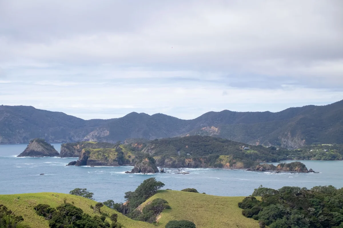
One of the most captivating aspects of the Queen Charlotte Track is the constant change in perspective. One moment you are deep in a cool, shaded gully filled with the scent of damp earth and ferns; the next, you emerge onto a sun-drenched ridge-line where the view expands to encompass the entire Marlborough Sounds. To the north, the deep blue of the Queen Charlotte Sound is dotted with yachts and ferries; to the south, the shallower, emerald-green waters of the Kenepuru Sound provide a stunning contrast. This visual drama, combined with the logistical ease of water taxi support, makes the Queen Charlotte Track one of the most popular and rewarding multi-day experiences in New Zealand.
History and Cultural Context
The Marlborough Sounds, or Te Tau Ihu o te Waka-a-Māui (the prow of the canoe of Māui), have a human history stretching back nearly 800 years. For Māori, the Sounds were a vital source of kaimoana (seafood) and a strategic location for settlement and travel. The area around the track was traditionally inhabited by several iwi (tribes), including Ngāti Kuia, Rangitāne o Wairau, and Ngāti Apa ki te Rā Tō, before the arrival of Te Ātiawa in the early 19th century. The track itself follows many ancient routes used by Māori to travel between the various inlets and to portage waka (canoes) across narrow necks of land, such as the Torea Neck, to avoid long and dangerous sea journeys around the outer headlands.
European history on the track is dominated by the presence of Captain James Cook. Ship Cove (Meretoto) served as his primary base in New Zealand during his three voyages of discovery. Cook found the cove to be an ideal harbour, providing fresh water, timber for repairs, and wild greens (such as "Cook’s scurvy grass") to combat disease among his crew. The interactions between Cook’s crew and the local Māori at Ship Cove are among the most documented early encounters in New Zealand history, marked by both trade and cultural misunderstanding. Today, a large monument at Ship Cove commemorates these visits, and the area is managed as a historic reserve.
Following the colonial era, the Marlborough Sounds became a hub for whaling, gold mining, and pastoral farming. Many of the bays you pass through today were once bustling with activity. Endeavour Inlet was the site of a significant antimony mine in the late 1800s, the remains of which can still be found hidden in the bush. As farming became less viable on the steep, rugged hillsides, much of the land was allowed to regenerate into native forest. The Queen Charlotte Track was officially opened in the early 1980s, born from a vision to connect these historic sites and scenic reserves into a continuous walking route. The unique cooperation between private landowners and the government remains a testament to the community's commitment to sharing this spectacular landscape with the world.
Want more background? Read extended notes on history and cultural context → Learn more
Seasonal Highlights and Weather Reality
The Queen Charlotte Track is one of the few multi-day walks in New Zealand that remains accessible and enjoyable year-round. Its coastal location and relatively low elevation mean it escapes the heavy snow and extreme alpine conditions that close other tracks during the winter months. However, each season offers a distinct experience.
Summer (December to February): This is the peak season. The weather is generally warm and settled, with temperatures ranging from 20°C to 28°C. The long daylight hours are perfect for swimming in the bays after a day of walking. However, this is also the busiest time on the track and in the lodges. Cicadas provide a constant soundtrack, and the sun can be intense on the exposed ridge-lines. Early bookings for accommodation and water taxis are essential.
Autumn (March to May): Many locals consider this the best time to walk. The heat of summer fades into crisp, clear days and calm seas. The water remains warm enough for a quick dip, and the track is significantly quieter. In late autumn, you may encounter the "wasp season" in the beech forests, where invasive common wasps are attracted to the honeydew produced by scale insects. While usually just a nuisance, those with allergies should take extra care.
Winter (June to August): Winter brings cool, fresh air and often the clearest views of the year. While temperatures can drop to 5°C or lower at night, daytime walking temperatures are often a comfortable 10°C to 15°C. The track is very quiet, offering a sense of solitude. Some private lodges close during this period, so accommodation options may be more limited to DOC campsites and year-round hostels.
Spring (September to November): The forest comes alive in spring with new growth and the frantic activity of nesting birds. Rainfall can be higher during this transition season, and the track can become muddy in places. However, the sight of the kōwhai trees flowering in brilliant yellow along the shoreline is a highlight not to be missed. The weather can be unpredictable, so high-quality waterproof gear is a must.
Recommended Itinerary
Standard 4-Day Walking Itinerary
Day 1: Ship Cove to Endeavour Inlet
- Distance: 15 km
- Elevation gain: 450 m
- Time: 4–5 hours
- Morning water taxi from Picton to Ship Cove (approx. 1 hour)
- Explore the Captain Cook memorial and historic displays at Ship Cove
- Initial steep climb through mature podocarp forest to a saddle with views of Motuara Island
- Descend into Resolution Bay, following the shoreline
- Cross a low ridge into Endeavour Inlet, passing through regenerating forest
- Arrive at accommodation in Endeavour Inlet (various lodges and a DOC campsite)
- The forest in this section is particularly lush, with large tree ferns and ancient beech trees
Day 2: Endeavour Inlet to Camp Bay
- Distance: 11.5 km
- Elevation gain: 250 m
- Time: 3–4 hours
- A gentler day following the shoreline of the deep Endeavour Inlet
- Pass the site of the historic antimony mines (short side trips available)
- Walk through private property and past holiday homes (bachs) nestled in the bush
- Cross the head of the inlet and follow the western shore
- Arrive at Camp Bay or Punga Cove
- This is the easiest section of the track, allowing time for a relaxed lunch or a swim
- Excellent birdwatching opportunities, especially for weka and fantails
Day 3: Camp Bay to Torea Bay
- Distance: 23 km
- Elevation gain: 950 m
- Time: 7–8 hours
- The most challenging and spectacular day of the track
- Steep climb from Camp Bay to the ridge-line separating Queen Charlotte and Kenepuru Sounds
- Follow the undulating ridge for several kilometres with 360-degree views
- Pass the Eatwell Lookout (highly recommended side trip for the best views on the track)
- The terrain is more exposed here, with manuka and kanuka scrub replacing the tall forest
- Descend steeply to Torea Saddle, then down to Torea Bay or Portage
- Requires good stamina and plenty of water, as there are no refill points on the ridge
Day 4: Torea Bay to Anakiwa
- Distance: 20 km
- Elevation gain: 750 m
- Time: 6–7 hours
- Climb back to the ridge from Torea Saddle
- Follow the ridge-line through the Lochmara and Onahau sections
- Spectacular views over the inner Queen Charlotte Sound and the Grove Arm
- Final long descent through magnificent beech and podocarp forest towards Anakiwa
- Pass through the Davies Bay campsite, a popular spot for a final break
- Finish at the Anakiwa jetty for the afternoon water taxi back to Picton
- The final few kilometres are on a wide, easy path through some of the most beautiful forest on the track
Important Notes:
- The track can be walked in either direction, but North to South (Ship Cove to Anakiwa) is the traditional route
- Water taxis must be booked in advance, especially if you require luggage transfers
- The QCTLC Landpass is required for the sections crossing private land (Day 2, 3, and 4)
- Mountain bikers generally complete the track in 2 or 3 days
- Water on the ridge-lines is non-existent; carry at least 2–3 litres on Day 3 and 4
Planning and Bookings
Book Your Trip
Everything you need to plan your journey
Accommodation
Find places to stay near Picton
Flights
Search flights to Picton
Essential Preparation
Planning for the Queen Charlotte Track is unique because of the variety of ways it can be experienced. Your first decision is whether to go "independent" (carrying all gear and camping) or "supported" (using luggage transfers and staying in lodges). Most walkers choose the supported option, which allows for a lighter day-pack and more comfort. Picton is the essential base for all track logistics. It is a charming port town accessible by ferry from Wellington or by road/air from other parts of the South Island. You should aim to arrive in Picton at least one day before your walk to collect your QCTLC pass, confirm water taxi bookings, and purchase any last-minute supplies.
Fitness is a key consideration. While the track is well-maintained, the daily distances (up to 23 km) and the cumulative elevation gain are significant. Ensure you have spent time walking in your chosen footwear and are comfortable with consecutive days of 6–8 hours of activity. If you are mountain biking, be aware that some sections are technical (Grade 3/4) and require good off-road skills.
Trail Accommodation
The Queen Charlotte Track offers a spectrum of accommodation that is arguably the best of any multi-day track in New Zealand. Because the track passes through private land and near small settlements, you are not limited to basic huts.
DOC Campsites: There are several Department of Conservation campsites along the route (Schoolhouse Bay, Resolution Bay, Endeavour Inlet, Camp Bay, Cow Shed Bay, Black Rock, Davies Bay). These are basic, providing flat sites for tents, non-treated water, and pit toilets. Some have cooking shelters. Bookings are required for these sites through the DOC website, especially during the summer season. Costs are approximately NZ$15 per adult per night.
Private Lodges and Hostels: This is where the Queen Charlotte Track shines. You can find everything from basic backpacker dorms to luxury eco-lodges with hot tubs and fine dining. Key locations for private accommodation include Endeavour Inlet, Punga Cove, and Portage/Torea Bay. Many of these lodges offer "track packages" that include meals and luggage transfers. These must be booked directly with the providers well in advance for the summer months.
What is NOT provided: Even if staying in lodges, you will generally need to provide your own lunch and snacks for the trail. DOC campsites do not provide any cooking equipment, fuel, or lighting. There are no DOC huts (with bunks) on this track, only campsites.
Required Gear
- Footwear: Sturdy walking shoes or light tramping boots. The track is well-formed, so heavy alpine boots are generally unnecessary, but good grip and ankle support are important for the ridge sections.
- Clothing: A layered system is essential. Include a moisture-wicking base layer (merino or synthetic), a warm fleece or wool mid-layer, and a high-quality waterproof and windproof jacket.
- Sun Protection: The New Zealand sun is exceptionally strong. Bring a wide-brimmed hat, high-SPF sunscreen, and quality sunglasses.
- Navigation: While the track is very well-marked with orange triangles and directional signs, a physical map or a reliable offline GPS app (like Topo50) is recommended.
- Safety Gear: A basic first aid kit (including blister pads), a whistle, and a head torch with spare batteries.
- Pack: If using luggage transfers, a 20–30L day-pack is sufficient. If camping, a 50–65L tramping pack is required.
What to Bring
- Water Treatment: Water at DOC campsites and some lodges is collected from roofs or streams and is untreated. Bring a filter, UV purifier, or chlorine tablets.
- Food: If camping, bring all meals and snacks. If staying in lodges, you may still need to bring breakfast and lunch supplies depending on your booking. High-energy snacks (nuts, chocolate, dried fruit) are vital for the long ridge days.
- Hydration: At least two 1-litre water bottles or a large hydration bladder. There is no water available on the ridge-lines between Camp Bay and Anakiwa.
- Toiletries: Biodegradable soap and shampoo, toothbrush, and a small towel. If camping, bring your own toilet paper and hand sanitiser.
- Insect Repellent: Sandflies can be a nuisance in the bays, and wasps are common in late summer. Bring a repellent with DEET or Picaridin.
- QCTLC Landpass: You must carry this on you at all times while on the track.
Permits
The Queen Charlotte Track is unique because it crosses a significant amount of private land. To facilitate this access, the Queen Charlotte Track Landowners Cooperative (QCTLC) requires all users to purchase a "Landpass." This fee goes directly towards the maintenance of the track sections on private property and ensures the continued cooperation of the landowners.
QCTLC Landpass Requirements:
- A pass is required for any person (walker or biker) using the sections of the track between Kenepuru Saddle and Torea Saddle, and between Torea Saddle and Anakiwa.
- Costs: A 1-day pass is NZ$15, and a multi-day pass (valid for up to 5 consecutive days) is NZ$30. An annual pass is also available for NZ$45.
- Where to buy: Passes can be purchased online via the QCTLC website, at the Picton i-SITE, from water taxi operators, or at many of the lodges along the track.
- Children under 15 years of age can use the track for free.
DOC Campsite Bookings:
If you are planning to camp, you must book your sites in advance through the Department of Conservation's online booking system. Unlike the Great Walks, there is no "permit" for the track itself, only the Landpass and your individual accommodation bookings. During the peak summer season (December to February), campsites can fill up, so booking several months in advance is recommended.
Water Taxi Logistics:
While not a "permit" in the legal sense, booking your water taxi is a mandatory part of the logistics. Most walkers book a "round trip" which includes the drop-off at Ship Cove and a pick-up at Anakiwa. If you are using luggage transfers, you must coordinate this with your taxi company. They will provide you with tags for your bags and instructions on where to leave them each morning.
Other Activities in the Area
The Marlborough Sounds is a playground for outdoor enthusiasts. If you have extra time before or after your walk, consider these activities:
- Sea Kayaking: The calm, sheltered waters of the Sounds are perfect for kayaking. You can rent kayaks in Picton, Anakiwa, or at several lodges along the track. Guided tours offer the chance to explore hidden coves and see marine life up close.
- Wildlife Tours: Take a boat tour to Motuara Island Bird Sanctuary, where you can see rare birds like the South Island saddleback and the Marlborough pied shag. Many tours also include dolphin watching, with dusky, bottlenose, and the rare Hector’s dolphins frequently seen in the Sounds.
- Mountain Biking: If you aren't riding the whole track, you can take a water taxi to a specific point and ride a section. The section from Kenepuru Saddle to Anakiwa is a popular day ride.
- Wine Tasting: You are at the doorstep of the world-famous Marlborough wine region. Take a short drive or train ride from Picton to Blenheim to visit some of the country’s best Sauvignon Blanc producers.
- Marlborough Museum: Located in Blenheim, this museum offers excellent exhibits on the region's Māori history, the arrival of Captain Cook, and the development of the wine industry.
- Eco-Tours: Several operators offer tours focused on the restoration of the Sounds, including visits to predator-free islands and reforestation projects.
Safety and Conditions
Track Conditions: The Queen Charlotte Track is generally well-maintained, but it is still a wilderness environment. After heavy rain, the track can become slippery and muddy, particularly in the forested sections. In summer, the clay-based soil can bake hard and become slick if a light rain falls. Always check the latest track alerts on the DOC website before starting.
Weather Awareness: While the Marlborough Sounds has a relatively mild climate, it is subject to sudden changes. Strong winds can buffet the ridge-lines, making walking difficult and increasing the risk of hypothermia if you are wet. Always carry a waterproof jacket, even if the sky is blue when you start. Check the MetService "Marlborough Sounds" forecast daily.
Water and Hydration: This is the most common safety issue on the track. The ridge-line sections (Day 3 and 4) have no natural water sources. In the heat of summer, walkers can easily become dehydrated. You must carry at least 2 litres of water for these sections. All water from DOC campsites and streams should be treated by boiling, filtering, or chemical tablets to prevent Giardia.
Communication: Mobile phone coverage is patchy. It is generally available on the high ridge-lines but non-existent in many of the deep bays and inlets. Do not rely on your phone for emergency communication. If you are walking alone or in the off-season, carrying a Personal Locator Beacon (PLB) is highly recommended. These can be hired in Picton.
Wasps and Bees: In late summer and autumn (February to April), wasps can be numerous in the beech forests. They are attracted to protein and sugar. If you have a known allergy to stings, you must carry an EpiPen and notify your companions. Avoid wearing bright colours or strong perfumes during this time.
Shared Use: Remember that the track is shared with mountain bikers. Walkers have the right of way, but bikers can approach quickly and quietly. Stay alert, especially on blind corners, and keep to the left side of the track.
Side Trips and Points of Interest
Motuara Island: While technically not on the track, most water taxis offer a stop at this predator-free island sanctuary on the way to Ship Cove. A short, steep walk to the island's summit provides a stunning 360-degree view of the outer Sounds and Cook Strait. The island is a haven for native birds, and you are almost guaranteed to see the friendly South Island robin (toutouwai).
Eatwell Lookout: Located on the ridge between Camp Bay and Torea Bay, this is the highest point accessible from the track. The 10-minute detour is steep but rewards you with the most iconic view of the Marlborough Sounds—the narrow strip of land separating the blue Queen Charlotte Sound from the green Kenepuru Sound. It is the perfect spot for a long lunch break.
Antimony Mines: In Endeavour Inlet, a short side trail leads to the remains of the antimony mines that operated in the late 19th century. You can see old machinery, mine shafts (do not enter), and the remains of the tramways used to transport the ore to the shore. It is a fascinating glimpse into the industrial history of this now-peaceful area.
James Cook Memorial: Spend some time at Ship Cove at the start of your journey. The memorial and the interpretive panels provide a deep sense of the historical weight of this location. The small creek where Cook’s crew collected water still flows today, and the surrounding forest looks much as it did in 1770.
Davies Bay: On the final day, Davies Bay offers a beautiful, sheltered beach just a few kilometres from the finish at Anakiwa. It is a popular spot for a final swim or to simply sit and reflect on the journey before the water taxi arrives. The forest here is particularly impressive, with massive beech trees draped in moss and lichens.
Leave No Trace
The Queen Charlotte Track passes through a delicate coastal ecosystem and across private land. Maintaining the beauty of the track and the goodwill of the landowners depends on every walker following Leave No Trace principles. The Marlborough Sounds are a "drowned valley" system, meaning the land and sea are intimately connected; what happens on the track directly affects the marine environment.
Key Responsibilities:
- Pack it in, pack it out: There are no rubbish bins on the track or at DOC campsites. You must carry all your trash back to Picton. This includes organic waste like apple cores and banana peels, which can attract pests and take a long time to decompose in the coastal environment.
- Respect Private Land: Stay on the marked track at all times when crossing private property. Do not climb over fences or gates. Remember that the Landpass is a privilege that allows us to enjoy these beautiful areas.
- Protect the Water: When washing yourself or your dishes at campsites, ensure you are at least 50 metres away from any stream or the sea. Use only biodegradable soaps, and even then, use them sparingly.
- Toilets: Use the provided toilets at campsites and lunch shelters. If you are caught short between facilities, bury your waste at least 15–20 cm deep and at least 50 metres away from water and the track. Pack out your used toilet paper in a sealed bag.
- Wildlife: Do not feed the birds, especially the weka. Weka are notorious thieves and will raid your pack for food if left unattended. Feeding them human food makes them aggressive and dependent.
- Fire: Open fires are strictly prohibited along the entire length of the track due to the high fire risk in the scrub and forest. Use only portable gas stoves for cooking.