Pulpit Rock (Preikestolen) - Norway's Iconic Fjord Sentinel
Preikestolen, known internationally as Pulpit Rock, is arguably Norway's most famous natural landmark and one of the most spectacular viewing platforms on Earth. Perched 604 metres above the deep blue waters of the Lysefjord in the Ryfylke region, this massive granite plateau offers a breathtaking perspective of the glaciated landscape that defines the Norwegian fjords. The trail is a 7.6-kilometre round trip that has been meticulously upgraded by Nepalese Sherpas to handle its immense popularity while preserving the rugged mountain character of the terrain. Unlike many global landmarks of this stature, Preikestolen remains unfenced and raw, demanding respect from those who stand upon its 25-by-25-metre summit. It is a journey through birch forests, across granite slabs, and alongside alpine tarns, culminating in a view that has captured the imagination of travellers for over a century.
- Distance: 7.6 km return
- Duration: 4–5 hours
- Elevation Gain: 350 m
- Difficulty: Moderate
- Best Time: May to September
- Closest City: Stavanger
- Trailhead: Preikestolen BaseCamp (Parking fee applies)
- Highest Point: 604 m (Plateau summit)
Overview
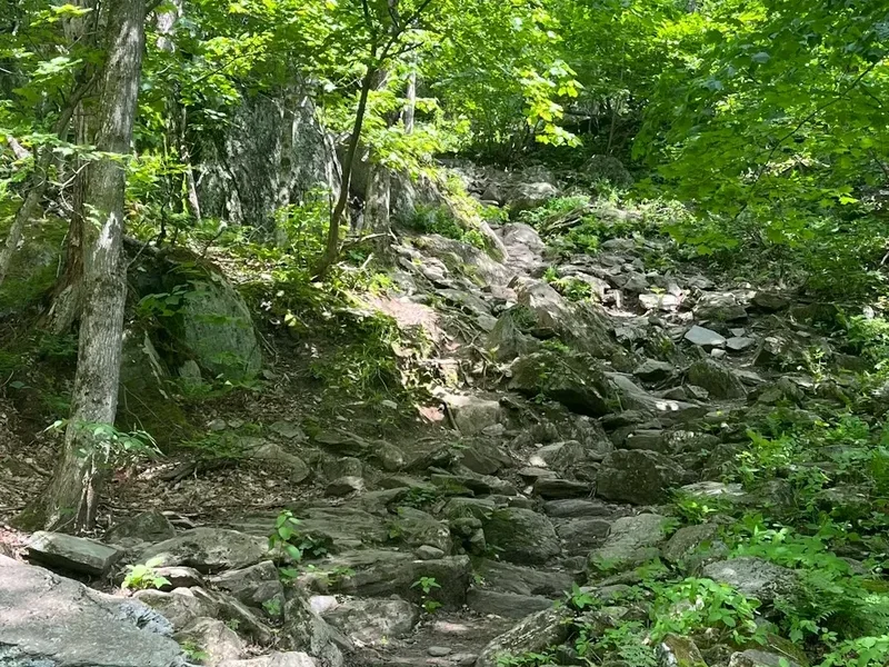
The hike to Preikestolen is a masterclass in Norwegian coastal mountain scenery. While the destination—the sheer-sided plateau—is the primary draw, the route itself provides a diverse experience of the Ryfylke landscape. The trail begins at approximately 270 metres above sea level and climbs to 604 metres, but the total ascent is closer to 350 metres due to the undulating nature of the path. The terrain is a mixture of gravel paths, boardwalks over marshy wetlands, and impressive stone stairways. These stairs, constructed from local granite by skilled Sherpas from Nepal, have transformed what was once a muddy and eroded scramble into a sustainable, well-defined mountain path that accommodates hundreds of thousands of visitors annually.
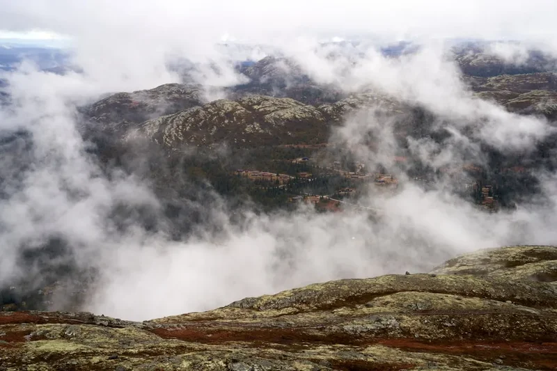
The Lysefjord, which stretches 42 kilometres below the plateau, was carved by massive glaciers during the last ice age. As you ascend, the vegetation transitions from dense birch and pine forests to the hardy mosses and lichens of the high alpine zone. The final kilometre of the trail is particularly dramatic, as the path skirts the edge of the mountain, offering tantalising glimpses of the fjord before the final turn reveals the massive, flat-topped "Pulpit" itself. The plateau is remarkably level, a geological anomaly that looks almost man-made from a distance, yet it is entirely a product of natural forces—specifically the expansion of ice in the mountain's cracks thousands of years ago.
For many, the experience of Preikestolen is defined by the lack of safety barriers. There are no fences or railings at the edge of the 604-metre drop. This "freedom under responsibility" is a core tenet of Norwegian outdoor culture, allowing for an unencumbered connection with the landscape. However, it also requires hikers to be mindful of their surroundings, especially in windy or wet conditions. Whether you are seeking a challenging morning workout or a slow-paced photographic expedition, Preikestolen delivers a sensory experience that is quintessentially Norwegian: rugged, beautiful, and profoundly humbling.
History and Cultural Context
The geological history of Preikestolen dates back approximately 10,000 years to the end of the last ice age. As the great glaciers that filled the Lysefjord began to melt and retreat, the release of pressure caused the granite walls to fracture. A massive block of ice likely remained wedged in a vertical crack in the mountain, and as it froze and expanded, it pushed the plateau outward, creating the distinct "Pulpit" shape we see today. A deep crack still runs across the plateau where it joins the mountain; while geological monitoring confirms the formation is stable, folk legend suggests that on the day seven sisters marry seven brothers from the Ryfylke region, the plateau will finally succumb to gravity and plunge into the fjord.
Despite its ancient origins, Preikestolen remained largely unknown to the wider world until the turn of the 20th century. It was "discovered" as a tourist destination in 1900 by Thomas Peter Randulff, a local bank manager and gymnastics enthusiast. While travelling on the steamer "Oscar II" through the Lysefjord, Randulff spotted the unusual rock formation from below. Intrigued, he set out to find the plateau from the mountain side. His successful trek marked the beginning of Preikestolen's journey from a local curiosity to a global icon. In the decades that followed, the Stavanger Turistforening (Stavanger Trekking Association) began marking the trail and building basic infrastructure to support the growing number of hikers.
In recent years, Preikestolen has transcended its status as a hiking destination to become a cultural touchstone. It gained significant international fame after featuring as a key filming location for the climax of "Mission: Impossible – Fallout," where Tom Cruise performed his own stunts on the cliff face. While the film set the scene in Kashmir, the unmistakable silhouette of the Lysefjord brought a new wave of global attention to Norway. Today, the site is managed with a focus on sustainability, balancing the preservation of the natural environment with the logistical demands of being one of Scandinavia's most visited outdoor attractions.
Want more background? Read extended notes on history and cultural context → Learn more
Seasonal Highlights and Weather Reality
The main hiking season for Preikestolen runs from May to September. During these months, the trail is generally free of snow, the days are long, and the bus services from Stavanger operate at full frequency. June and July offer the "Midnight Sun" experience, where the twilight lingers for hours, allowing for late-evening hikes that avoid the midday crowds. August brings the warmest temperatures, often reaching 20°C, though the weather in the fjords is notoriously fickle and can change from bright sunshine to heavy rain in minutes.
September is a favourite for many locals; the autumn colours turn the birch forests into a sea of gold and orange, and the crisp air provides exceptional visibility across the fjord. However, the days begin to shorten rapidly, and the first frosts can make the granite slabs slippery. May is also beautiful as the waterfalls are at their peak due to snowmelt, but hikers should be prepared for lingering snow patches on the higher sections of the trail.
Outside the main season (October to April), the hike transforms into a serious winter undertaking. The trail becomes covered in ice and deep snow, and the daylight hours are minimal. Hiking during this period is only recommended for those with significant winter mountain experience or those joining a guided tour. Crampons or ice spikes are mandatory, and the path can be difficult to follow if the trail markers are buried. The wind chill at the plateau in winter can be dangerous, with temperatures frequently dropping well below -10°C. Regardless of the season, the "Mountain Code" (Fjellvettreglene) should always be followed: turn back in time, and never shame yourself for doing so if the weather turns sour.
Recommended Itinerary
Standard Day Hike Itinerary
Early Morning: Departure and Arrival
- 07:00 – 08:00: Depart Stavanger via the Ryfylke tunnel (the world's longest and deepest undersea road tunnel).
- 08:15: Arrive at the Preikestolen BaseCamp parking area.
- 08:30: Final gear check at the trailhead. Use the facilities at the BaseCamp as there are no toilets on the trail.
- Starting early is the best way to beat the large tour groups that typically arrive after 10:00.
Morning: The Ascent
- 08:30 – 09:15: The first section involves a steep climb on a gravel path and the first set of Sherpa stairs. This section warms up the legs quickly.
- 09:15 – 10:00: The trail levels out across "Krogebekkmyra," a marshy plateau. Modern boardwalks protect the fragile wetland ecosystem here.
- 10:00 – 10:45: The "Neverdalsskaret" section. This is the most strenuous part of the hike, featuring a long, steep staircase built into a narrow mountain pass. Take your time and enjoy the views opening up behind you.
- 10:45 – 11:15: The trail reaches a high alpine plateau with several small lakes (tarns). This is a great spot for a quick water break before the final push.
Midday: The Plateau Experience
- 11:15 – 11:30: The final approach. The path narrows and follows a ledge with a safety chain on the mountain side. The first view of the Lysefjord appears here.
- 11:30 – 12:30: Arrival at Preikestolen. Spend time exploring the plateau, taking photographs, and eating lunch.
- For a different perspective, follow the red "T" marks up the hill behind the plateau to "Neverdalsfjellet" for a bird's-eye view of the Pulpit Rock with the fjord in the background.
- Be mindful of others; the plateau can get crowded, so be patient when waiting for photo opportunities.
Afternoon: The Descent
- 12:30 – 14:30: Begin the descent back to the BaseCamp. The stone stairs can be harder on the knees going down, so trekking poles are highly recommended.
- 14:30 – 15:00: Arrive back at the trailhead. Visit the Preikestolen Fjellstue for a celebratory coffee or meal.
- 15:30: Return journey to Stavanger or onward travel to other Ryfylke attractions.
Important Notes:
- The trail is well-marked with red "T" letters painted on rocks.
- There is no water available on the trail; carry at least 1.5 litres per person.
- The weather at the plateau is often much windier and colder than at the parking lot.
- In peak season (July), consider a "Sunset Hike" starting at 17:00 to enjoy the plateau in the golden hour with fewer people.
Planning and Bookings
Book Your Trip
Everything you need to plan your journey
Accommodation
Find places to stay near Stavanger
Flights
Search flights to Stavanger
Essential Preparation
While the hike to Preikestolen is classified as moderate, it should not be underestimated. A basic level of cardiovascular fitness is required to manage the 350-metre elevation gain over uneven stone steps. Most hikers find the ascent takes about 2 to 2.5 hours. Preparation begins in Stavanger, the regional hub. Ensure you have checked the local weather forecast (Yr.no is the most accurate for Norway) specifically for "Preikestolen" rather than just Stavanger, as the mountain weather differs significantly from the coast.
Logistically, the opening of the Ryfylke tunnel (Ryfast) has made access much simpler. You no longer need to rely on the ferry from Stavanger to Tau. You can drive directly or take the dedicated "Pulpit Rock Bus" which runs frequently during the summer season. If you are driving, be aware that the parking lot uses an automated number plate recognition system; you can pay at the machines before leaving or online within 48 hours.
Trail Accommodation
Preikestolen is primarily a day hike, and there is no accommodation directly on the trail or at the plateau itself. However, there are several excellent options at the trailhead and in the surrounding area.
Preikestolen BaseCamp: Located at the start of the trail, this facility offers a range of options from the modern Preikestolen Fjellstue (mountain lodge) to the more rustic Hikers' Camp and even "Vatnebu" (wooden pods). Booking in advance is essential during June, July, and August. The Fjellstue provides high-quality meals and a comfortable lounge with fjord views.
Camping: Wild camping is permitted in Norway under the "Allemannsretten" (Right to Roam) laws, but there are specific restrictions around Preikestolen due to the high volume of visitors. You are not allowed to camp on the plateau itself or in the immediate vicinity of the trail to protect the vegetation and water sources. There are designated campsites near the BaseCamp and further down the road toward Jørpeland. If you choose to wild camp further away, you must be at least 150 metres from inhabited houses and leave no trace of your stay.
Stavanger: Most visitors choose to stay in Stavanger, which offers everything from luxury hotels to budget hostels. The city is only a 40-minute drive or bus ride away, making it a convenient base for the hike.
Required Gear
- Hiking Boots: Sturdy boots with good ankle support and a grippy sole (Vibram or similar) are essential. The granite can be very slippery when wet, and the uneven steps require stability.
- Waterproof Layers: A high-quality waterproof jacket and overtrousers. Even if the sun is shining at the start, the Lysefjord is known for sudden, heavy rain showers.
- Insulating Layers: A fleece or woollen mid-layer. The wind at the 604-metre summit can be biting, even in mid-summer.
- Backpack: A 20–30 litre daypack with a rain cover.
- Trekking Poles: Highly recommended for the descent to reduce impact on the knees, especially on the Sherpa stairs.
- Navigation: While the trail is well-marked, a downloaded offline map (like UT.no or Google Maps) is a sensible backup.
What to Bring
- Food: A substantial packed lunch and high-energy snacks (nuts, chocolate, or Norwegian "Kvikk Lunsj" biscuits). There are no food outlets once you leave the BaseCamp.
- Water: At least 1.5 to 2 litres of water. While there are streams, they are not monitored for quality, so carrying your own or using a filter is advised.
- Sun Protection: Sunscreen, sunglasses, and a hat. The sun can be intense at higher altitudes, and there is very little shade on the upper half of the trail.
- First Aid: A basic kit including blister plasters (Compeed), antiseptic wipes, and any personal medications.
- Power Bank: Cold temperatures and frequent photo-taking can drain phone batteries quickly.
- Trash Bag: To carry out all your waste, including fruit peels and tissues.
Permits

One of the great advantages of hiking in Norway is that no permits are required to hike to Preikestolen. Access to the mountains is free for everyone under the "Allemannsretten" law. You do not need to book a time slot or pay an entry fee to walk the trail. This openness is a point of national pride, but it also means that the trail can become very crowded during peak periods.
Associated Costs:
- Parking: While the trail is free, the parking at the trailhead is managed by a private foundation and the fees are used to maintain the trail, toilets, and emergency services. As of 2024, the fee is approximately 250 NOK for a car for the day.
- Transport: If you do not have a car, the "Pulpit Rock Bus" from Stavanger costs approximately 400–500 NOK for a return ticket. The Ryfylke tunnel also has a toll (approximately 160 NOK each way for a standard vehicle, though this is often handled via an automated tag).
- Guided Tours: If you choose to hike in the off-season or want a sunrise/sunset experience with professional guidance, tours typically cost between 900 and 1,500 NOK per person.
Crowd Management: Because no permits are required, the number of hikers is not capped. On a sunny Saturday in July, there can be over 5,000 people on the trail. To have a more "wilderness" experience, aim to start your hike before 08:00 or after 16:00. The trail is open 24 hours a day, so sunrise and sunset hikes are popular and legal options.
Other Activities in the Area
The Ryfylke region and the city of Stavanger offer a wealth of experiences to complement your hike:
- Lysefjord Sightseeing Cruise: See Preikestolen from below. Boats depart from Stavanger and sail deep into the fjord, stopping at "Vagabond's Cave" and passing directly under the Pulpit Rock. It provides a completely different perspective on the scale of the cliffs.
- Kjeragbolten Hike: For those seeking a more challenging adventure, the hike to Kjerag is located further into the Lysefjord. It features the famous "boulder" wedged in a mountain crevice 1,000 metres above the water. It is a much tougher 6–8 hour hike.
- Flørli 4444: Visit the roadless village of Flørli and climb the world's longest wooden staircase—4,444 steps following an old water pipeline up the mountainside.
- Old Stavanger (Gamle Stavanger): Explore the best-preserved settlement of 18th-century wooden houses in northern Europe. The white-painted cottages and cobblestone streets are incredibly photogenic.
- Norwegian Petroleum Museum: A surprisingly engaging museum in Stavanger that explains the industry that built modern Norway, featuring interactive exhibits and offshore rig models.
- Sola Beach: A stunning stretch of white sand near Stavanger, perfect for a post-hike swim or a walk through the dunes.
Safety and Conditions
Pre-Departure Checks:
- Check the weather forecast on Yr.no. Look for wind speeds and visibility; fog can make the plateau experience disappointing and the trail disorienting.
- Ensure your phone is fully charged and you have the local emergency number (112) saved.
- Inform someone of your plans and expected return time.
- Check the "Preikestolen 365" social media pages or local news for any temporary trail closures or warnings.
Trail Hazards: The most common injuries on the Preikestolen trail are twisted ankles and slips on wet granite. The Sherpa stairs are well-built but can be uneven. During periods of heavy rain, small streams can overflow onto the path, making sections muddy. The wind at the plateau is the most significant environmental hazard; it can be strong enough to knock a person off balance. Always stay a safe distance from the edge, especially when taking photos. Do not attempt to sit on the edge if it is windy or if the rock is wet.
Emergency Services: The Norwegian People's Aid (Norsk Folkehjelp) has a summer station near the trailhead and patrols the path during peak hours. However, a rescue operation by helicopter or stretcher is complex and time-consuming. If you encounter someone in distress, provide assistance if possible and call 112. Be prepared to give your location based on the numbered signs located every 500 metres along the trail.
The Mountain Code: Norway's "Fjellvettreglene" are essential for all hikers. Key points include: plan your trip and inform others, adapt the planned route according to ability and conditions, pay attention to the weather and avalanche warnings, be equipped for bad weather and frost even on short trips, and turn back in time—there is no shame in turning around.
Side Trips and Points of Interest
The "Hidden" Viewpoint: Most people stop at the main plateau. However, if you follow the trail marked with red dots that leads steeply up the hill behind the plateau (toward the summit of Neverdalsfjellet), you will reach a much higher vantage point. From here, you can look down onto the flat top of Preikestolen with the entire length of the Lysefjord stretching out behind it. This is where the most iconic "aerial" style photos are taken.
Tjødnane Lakes: About three-quarters of the way up, the trail passes a series of small alpine lakes. On a warm summer day, these are popular spots for a quick, refreshing (and very cold) dip. The water is crystal clear and the surrounding granite slabs make for a perfect natural picnic area away from the main flow of hikers.
The Sherpa Stairs: Take a moment to appreciate the engineering of the stone steps. Built between 2013 and 2014, these stairs were a massive undertaking. The stones were moved into place using helicopters and manual winches. The design allows water to drain away from the path, preventing the erosion that nearly destroyed the trail a decade ago. The craftsmanship is a testament to the shared mountain culture between Norway and Nepal.
Vatneberget: Near the start of the hike, a short detour leads to a viewpoint overlooking the Revsvatnet lake. It is a peaceful spot that many rush past in their hurry to reach the Pulpit, but it offers a lovely perspective on the lush valley below the mountain.
Leave No Trace

Preikestolen is a victim of its own success, with over 300,000 visitors a year. To keep this landscape beautiful and accessible, every hiker must strictly adhere to Leave No Trace principles. The environment at 600 metres is fragile; plants grow slowly and the soil is thin.
Your responsibility as a hiker:
- Pack it in, pack it out: This includes everything from plastic bottles to orange peels and cigarette butts. There are no bins on the trail.
- Stay on the path: Walking off-trail creates "social paths" that lead to erosion and destroy the mosses and heather that hold the soil together.
- Respect the water: Do not wash yourself or your dishes in the alpine tarns using soap. Even biodegradable soap can harm the delicate balance of these small ecosystems.
- No Drones: While not strictly banned in all areas, drone use is highly discouraged and often restricted during peak hours to preserve the peace and privacy of other hikers. Always check current local regulations.
- Toilets: Use the toilets at the BaseCamp before you start. If you are caught short on the trail, move at least 50 metres from the path and any water sources, and bury your waste. Pack out your toilet paper in a sealed bag.
- Wildlife: You may see sheep grazing near the start of the trail. Keep your distance and never feed them. Dogs must be kept on a leash at all times (this is a legal requirement in Norway from April to August).