Pulpit Rock (Preikestolen) - Norway’s Natural Masterpiece
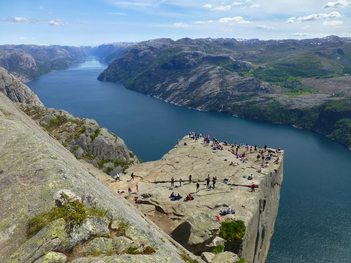
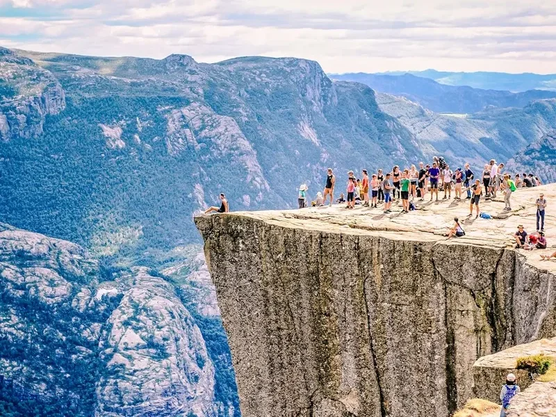
Preikestolen, known internationally as Pulpit Rock, is arguably the most iconic natural landmark in Norway and a premier destination for hikers worldwide. Perched 604 metres above the crystalline waters of the Lysefjord, this massive granite plateau measures approximately 25 by 25 metres, offering a flat, square surface that looks as though it was precision-carved by the gods. Located in the Ryfylke region near the city of Stavanger, the hike to Preikestolen is a 7.6-kilometre round-trip journey that traverses a diverse landscape of mountain bogs, ancient granite boulders, and steep stone stairways. It is a walk that perfectly encapsulates the raw, vertical beauty of the Norwegian fjords, providing a sensory experience that combines physical exertion with a profound sense of geological scale.
The trail is classified as moderate, making it accessible to a wide range of walkers, yet it retains a wild, rugged character that demands respect. Unlike many famous viewpoints globally, Preikestolen remains in its natural state; there are no safety fences or railings at the edge of the 600-metre drop, a testament to the Norwegian philosophy of "friluftsliv" (open-air life) which emphasises personal responsibility and an unmediated connection with nature. Whether shrouded in the ethereal mist of a coastal morning or bathed in the golden light of the midnight sun, the plateau provides a vantage point that is nothing short of transformative. It is a journey through a landscape shaped by the immense power of the last ice age, leading to a destination that has become a symbol of Norway’s enduring wilderness.
- Distance: 7.6 km (round trip)
- Duration: 4–5 hours
- Elevation Gain: 350 m
- Difficulty: Moderate
- Highest Point: 604 m (at the plateau)
- Season: April to October (winter hiking requires specialised equipment and guides)
- Closest City: Stavanger
- Trailhead: Preikestolen BaseCamp / Fjellstue
Overview
The hike to Preikestolen is a masterclass in trail engineering and natural beauty. While the destination is the primary draw, the route itself offers a fascinating progression through several distinct ecological zones. Starting from the Preikestolen BaseCamp at approximately 270 metres above sea level, the trail ascends through a mixture of lush birch forests, expansive marshlands, and dramatic scree slopes. The path has seen significant improvements in recent years, most notably the installation of extensive stone stairways crafted by Nepalese Sherpas. these "Sherpa steps" have not only made the ascent more manageable for the hundreds of thousands of annual visitors but have also protected the fragile mountain ecosystem from erosion caused by heavy foot traffic.
The terrain is varied and engaging. Walkers will encounter sections of flat, wooden boardwalks designed to protect the delicate peat bogs, followed by steep, rhythmic climbs over granite blocks. As the elevation increases, the vegetation thins, revealing the stark, grey beauty of the Ryfylke mountains. The final kilometre of the trail is perhaps the most spectacular, as the path levels out and hugs the cliffside, offering the first tantalising glimpses of the Lysefjord far below. The fjord itself stretches 42 kilometres into the heart of the mountains, its steep walls rising nearly vertically from the water. The contrast between the dark, deep water and the pale granite cliffs creates a visual drama that is unique to the Norwegian landscape.
Reaching the plateau is a moment of genuine awe. The sheer verticality of the drop is difficult for the human mind to process initially. From the edge, you can look down at the tiny tour boats navigating the fjord, appearing like miniature toys against the scale of the cliffs. To the east, the fjord winds deeper into the mountains toward the village of Lysebotn and the famous Kjeragbolten. To the west, the landscape opens up toward the islands of the coast and the North Sea. The plateau is large enough to accommodate many visitors, yet it is easy to find a quiet corner to sit and absorb the silence of the heights. This is not just a hike; it is a pilgrimage to one of the world's most spectacular natural balconies.
History and Cultural Context
The geological history of Preikestolen dates back approximately 10,000 years to the end of the last ice age. As the massive Scandinavian ice sheet began to melt and retreat, the pressure on the mountains was released, and the freezing and thawing of water in the granite cracks caused large sections of rock to fracture. The Lysefjord was carved out by a glacier, and Preikestolen is a remnant of this glacial activity—a block of granite that remained standing while the surrounding ice eroded the valley around it. The famous crack that runs across the plateau is a result of these ancient geological stresses; while it may look precarious, geologists monitor the site closely and have confirmed that the plateau remains stable, though it will, in a geological timeframe of thousands of years, eventually succumb to the forces of erosion.
Culturally, Preikestolen remained largely unknown to the wider world until the late 19th century. Local farmers and hunters were certainly aware of the formation, but it held little practical value in a landscape where survival depended on fertile soil and accessible grazing. The "discovery" of Preikestolen as a tourist destination is credited to Thomas Peter Randulff, a local bank manager and athlete, who spotted the unusual square formation from a boat on the Lysefjord in 1900. Recognising its potential, he set out to find an overland route to the top. His successful ascent marked the beginning of the area's transformation from a remote mountain pasture to a global icon.
In recent decades, Preikestolen’s fame has grown exponentially, aided by its inclusion in major international media. Most notably, the plateau served as the dramatic backdrop for the climactic fight scene in the 2018 film Mission: Impossible – Fallout. While the film set the scene in Kashmir, the unmistakable silhouette of Pulpit Rock brought a new wave of global attention to Norway. Despite this commercial fame, the site remains deeply connected to the Norwegian identity. It represents the national love for the outdoors and the belief that nature should be accessible to all, provided it is treated with the respect and caution it deserves. The name "Preikestolen" itself translates to "The Preacher's Chair" or "The Pulpit," reflecting the rock's resemblance to the elevated platforms found in traditional churches.
Want more background? Read extended notes on history and cultural context → Learn more
Seasonal Highlights and Weather Reality
The primary hiking season for Preikestolen runs from April to October, with the peak months being June, July, and August. During the height of summer, Norway experiences the phenomenon of the midnight sun, where the sun barely dips below the horizon. This allows for incredibly long hiking days; many experienced walkers choose to start their journey at 2:00 AM or 3:00 AM to reach the plateau for sunrise, avoiding the midday crowds and experiencing the fjord in a hauntingly beautiful, soft light. Summer temperatures are generally mild, ranging from 10°C to 20°C, but the weather in the fjords is notoriously fickle. A clear morning can transform into a torrential downpour within thirty minutes, and the plateau can become shrouded in thick "sea fog" that obscures all views.
The shoulder seasons of April–May and September–October offer a different, quieter experience. In the spring, the trail is often lined with melting snow and rushing seasonal waterfalls, while the autumn brings a spectacular palette of deep oranges and reds to the birch forests. However, these months require more careful planning. Snow can linger on the upper sections of the trail well into May, making the granite surfaces extremely slippery. In October, the days shorten rapidly, and the risk of frost increases. Hikers during these periods should be prepared for colder temperatures and potentially icy conditions underfoot.
Winter hiking (November to March) is a serious undertaking and is not recommended for the average tourist without a professional guide. The trail becomes covered in deep snow and ice, and the steep sections can be treacherous. Daylight is limited to just a few hours, and temperatures can drop well below freezing. For those with the correct equipment—including crampons, ice axes, and high-quality thermal gear—a winter ascent offers a stark, monochromatic beauty and a level of solitude that is impossible to find in summer. However, the risk of avalanches and the difficulty of navigation in whiteout conditions mean that safety must be the absolute priority. Several local guiding companies offer "Sunrise Winter Hikes," which provide the necessary safety gear and expertise to experience the plateau in its most extreme and majestic state.
Recommended Itinerary
Preikestolen Day Hike Progression
Stage 1: Preikestolen BaseCamp to the First Ascent
- Distance: 0.0 km – 1.0 km
- Elevation Gain: 80 m
- Time: 30–45 minutes
- The trail begins at the Preikestolen BaseCamp, located near the large parking areas.
- The initial section is a well-maintained gravel path that climbs steadily through a birch forest.
- You will quickly encounter the first set of Sherpa-built stone steps, which help navigate a steep, rocky section.
- This stage serves as a good warm-up, getting the heart rate up while still under the canopy of the trees.
- Look back occasionally for views of the Refsvatnet lake behind the BaseCamp.
Stage 2: The Marshlands and the Great Staircase
- Distance: 1.0 km – 2.5 km
- Elevation Gain: 150 m
- Time: 45–60 minutes
- After the initial climb, the terrain levels out into an area of mountain bogs and small lakes.
- Wooden boardwalks are provided to keep your boots dry and protect the fragile peat moss.
- Following the flat section, you reach the "Great Staircase"—the steepest part of the hike.
- This section consists of hundreds of stone steps rising through a narrow boulder field.
- Take your time here; there are several flat "resting spots" built into the side of the trail with stone benches.
- As you reach the top of the stairs, the vegetation disappears, replaced by the open granite landscape of the high plateau.
Stage 3: The High Plateau and Fjord Views
- Distance: 2.5 km – 3.5 km
- Elevation Gain: 70 m
- Time: 30–40 minutes
- The trail becomes much flatter here, winding across smooth granite slabs marked with red "T" symbols.
- You will pass several small alpine tarns (lakes) which are popular spots for a quick dip on hot summer days.
- The path begins to hug the edge of the mountain, and the first views of the Lysefjord start to appear to your right.
- The trail narrows in places, with a steep drop-off on one side, but the path is wide enough for two people to pass comfortably.
- This is the most scenic part of the approach, as the scale of the fjord becomes increasingly apparent.
Stage 4: The Final Approach and Preikestolen Plateau
- Distance: 3.5 km – 3.8 km
- Elevation Gain: Minimal
- Time: 15–20 minutes
- The final stretch involves walking along a natural ledge that leads directly onto the Pulpit Rock plateau.
- There is a short, slightly narrow section with a safety chain for those who feel uncomfortable with heights, though most hikers find it manageable.
- Suddenly, the path opens up, and you are standing on the 25x25 metre square of Preikestolen.
- Spend time exploring the plateau, but stay well back from the edges if the wind is strong.
- For a higher perspective, follow the small trail that climbs the rocks behind the plateau (often called "The Hill") for the classic "top-down" photo of the rock and the fjord.
- Return via the same route, allowing 1.5 to 2 hours for the descent.
Important Notes:
- The trail is a "there and back" route; there is no loop option.
- Total walking time is typically 4 hours, but allow 5–6 hours to include time for photos and a lunch break on the plateau.
- The descent can be harder on the knees than the ascent due to the high stone steps.
- In peak season (July), the trail can be very crowded; starting before 8:00 AM or after 4:00 PM is highly recommended.
- There are no toilets or rubbish bins on the trail; use the facilities at the BaseCamp before starting.
Planning and Bookings
Book Your Trip
Everything you need to plan your journey
Accommodation
Find places to stay near Stavanger
Flights
Search flights to Stavanger
Essential Preparation
Planning for Preikestolen begins with transport and timing. The hike is located approximately 40 kilometres from Stavanger. Since the opening of the Ryfylke Tunnel (Ryfast) in 2019—the world's longest and deepest subsea road tunnel—access has become significantly easier. You can now drive directly from Stavanger to the trailhead in about 40 minutes. If you do not have a car, several commercial bus operators (such as Pulpit Rock Tours and Go Fjords) run frequent shuttle services from Stavanger city centre and the bus terminal directly to the Preikestolen BaseCamp.
Fitness requirements are moderate. While you don't need to be an elite athlete, you should be comfortable walking for 4–5 hours with significant uphill sections. The stone steps require a certain amount of leg strength and balance. If you have knee issues, trekking poles are highly recommended for the descent. Before leaving Stavanger, check the weather forecast specifically for "Preikestolen" on Yr.no, as the weather at the coast can be very different from the weather at 600 metres elevation.
Trail Accommodation
As Preikestolen is a day hike, there is no accommodation on the trail itself. However, there are several excellent options at the trailhead and in the surrounding area.
Preikestolen BaseCamp: Located at the start of the trail, this facility offers three types of accommodation:
- Preikestolen Fjellstue: A modern mountain lodge with comfortable private rooms and an excellent restaurant serving local Norwegian cuisine.
- Preikestolen Hostel (Vatnebu): A more budget-friendly option with dormitory-style rooms and shared kitchen facilities.
- Hikers' Camp: Permanent canvas tents (glamping style) available during the summer months, providing a closer connection to nature with the comfort of a bed.
Camping: Wild camping is permitted in Norway under the "Allemannsretten" (Right of Access) law, provided you are at least 150 metres from inhabited houses and stay only one or two nights. However, camping directly on the Preikestolen plateau is discouraged due to the high volume of visitors and the lack of soil for waste management. There are several designated campsites within a 15-minute drive of the trailhead, such as Preikestolen Camping, which offers full facilities for tents and motorhomes.
Stavanger: Most visitors choose to base themselves in Stavanger, which offers a full range of hotels, hostels, and Airbnb options. This allows you to enjoy the city's vibrant food scene and historic "Gamle Stavanger" (Old Town) after your hike.
Required Gear
- Hiking Boots: Sturdy, waterproof boots with good ankle support are essential. The granite can be slippery when wet, and the stone steps require a solid grip. Do not attempt this hike in flip-flops or smooth-soled fashion trainers.
- Layered Clothing: The "three-layer principle" is best for Norway. A moisture-wicking base layer (merino wool is ideal), an insulating mid-layer (fleece or light down), and a high-quality waterproof and windproof outer shell.
- Trekking Poles: Highly recommended, especially for the descent. They significantly reduce the impact on your knees and provide extra stability on the uneven stone steps.
- Backpack: A 20–30 litre daypack with a rain cover to keep your spare clothes and food dry.
- Navigation: The trail is very well-marked with red "T" symbols painted on rocks, but an offline map (like Norgeskart or Maps.me) is useful in case of thick fog.
What to Bring
- Water: Bring at least 1.5 to 2 litres of water per person. While there are some streams along the way, they can dry up in late summer, and the water quality can be affected by the high number of hikers.
- Food and Snacks: There are no food outlets on the trail. Bring a substantial packed lunch and high-energy snacks like nuts, chocolate, or dried fruit. A celebratory sandwich on the plateau is a Norwegian tradition.
- Sun Protection: Even on cloudy days, the UV levels at altitude can be high. Bring sunscreen, sunglasses, and a hat.
- First Aid Kit: A basic kit containing blister plasters (Compeed), antiseptic wipes, and any personal medications.
- Power Bank: Cold temperatures and frequent photo-taking can drain phone batteries quickly. Ensure you have a way to keep your phone charged for navigation and emergencies.
- Trash Bag: You must carry out everything you carry in. There are no bins on the mountain.
Permits
One of the great advantages of hiking in Norway is that there are no permits required to hike to Preikestolen. Access to nature is considered a fundamental right. You do not need to book a time slot or pay an entry fee to walk the trail. However, there are costs associated with the infrastructure that supports the hike.
Parking Fees: If you are driving your own vehicle, you must pay for parking at the Preikestolen BaseCamp. As of 2024, the fee is approximately 250 NOK (approx. €22) for a passenger car for the day. This fee goes directly toward the maintenance of the trail, the Sherpa steps, and the emergency rescue services. The parking area uses an automated camera system (EasyPark or similar), so you can pay via an app or at the machines before you leave.
Transport Costs: If you are taking the shuttle bus from Stavanger, expect to pay between 300 NOK and 450 NOK for a round-trip ticket. While this may seem expensive, it is often cheaper than the combined cost of a rental car, fuel, and parking fees.
Guided Hikes: While not a permit, many people choose to pay for a guided experience. Prices for a guided day hike typically range from 900 NOK to 1,500 NOK per person. This includes transport, a professional guide, and often some additional gear or snacks. For winter hikes, a guide is strongly recommended for safety reasons.
Drone Regulations: While not a hiking permit, it is important to note that the use of drones is strictly regulated at Preikestolen. Due to the high volume of visitors and the presence of rescue helicopters, drone flying is often prohibited or requires specific authorisation. Always check the latest local signage and Norwegian Civil Aviation Authority rules before launching a drone.
Other Activities in the Area
The Ryfylke region and the city of Stavanger offer a wealth of experiences that complement a trip to Preikestolen:
- Lysefjord Sightseeing Cruise: If you want to see Preikestolen from below, take a boat trip from Stavanger. Seeing the massive overhang of the plateau from the water provides a completely different perspective on its scale. Most cruises also stop at "Hengjanefossen," a waterfall where the boat gets close enough for you to taste the mountain water.
- Kjeragbolten: For those seeking a more challenging hike, Kjerag is located further into the Lysefjord. It is famous for the "Bolten," a boulder wedged in a mountain crevice 1,000 metres above the fjord. The hike is significantly harder than Preikestolen (12 km, 6–8 hours) but equally rewarding.
- Flørli 4444: Visit the roadless village of Flørli and climb the world's longest wooden staircase. With 4,444 steps following an old water pipeline, it is a true test of endurance with spectacular fjord views.
- Stavanger Old Town (Gamle Stavanger): Explore the best-preserved collection of wooden houses in Northern Europe. Over 170 white wooden buildings from the 18th and 19th centuries line narrow cobblestone streets.
- Norwegian Petroleum Museum: Located in Stavanger harbour, this world-class museum explains how oil and gas have shaped modern Norway through interactive exhibits and impressive offshore technology.
- Sola Beach: Just a short drive from Stavanger, this long sandy beach is a popular spot for windsurfing, walking, and watching the sunset over the North Sea.
Safety and Conditions
Personal Responsibility: The most important safety rule at Preikestolen is to recognise that there are no fences. The edge is a 604-metre vertical drop. While it is tempting to get the "perfect photo" sitting on the edge, wind gusts can be sudden and powerful. Always maintain a safe distance from the rim, especially if the rock is wet or icy.
Weather Awareness: The weather can change in an instant. Fog is a major hazard; it can roll in from the fjord and reduce visibility to a few metres, making it easy to lose the trail. If visibility becomes poor, stay on the marked path and look for the red "T" symbols. If you lose the trail, stop and wait for the fog to clear or for another hiker to pass. Hypothermia is a risk even in summer if you get wet and the wind picks up; always carry your waterproof layers.
Footwear and Fatigue: Most injuries on the Preikestolen trail are twisted ankles or exhaustion-related slips, usually occurring on the descent. The stone steps are uneven and can be very slippery when wet. Take your time going down, and use trekking poles to maintain balance. If you feel exhausted, take a break; there is no shame in turning back if the conditions or your fitness levels aren't up to the task.
Emergency Services: In case of a serious injury, the emergency number in Norway is 112. The "Norsk Folkehjelp" (Norwegian People's Aid) maintains a voluntary rescue station near the trailhead during the peak season. However, a helicopter rescue is the only way to evacuate someone from the upper sections of the trail, and this is dependent on weather conditions. Always tell someone your plans and when you expect to be back.
Winter Hazards: From November to March, the trail is an alpine environment. Do not attempt the hike without spikes/crampons and a headlamp. The sun sets as early as 3:30 PM in December. If you are not experienced in winter mountain navigation, hire a guide.
Side Trips and Points of Interest
The "Top of the Top" (The Hill): Most people stop once they reach the flat plateau of Preikestolen. However, if you follow the faint trails that lead up the rocks behind the plateau, you can climb another 50–100 metres higher. From this elevated position, you get the iconic "postcard" view looking down onto the square plateau with the fjord stretching out behind it. It is also a much quieter place to sit and enjoy the view away from the main crowd.
The "Hidden" Ledge: Just before you reach the main plateau, there is a smaller, lower ledge that offers a fantastic view of the Pulpit Rock's profile. It is a great spot for photography, as it shows the sheer verticality of the rock face that you are about to stand on.
Tjødnane Lakes: About two-thirds of the way up, the trail passes a series of small alpine lakes called Tjødnane. On a calm day, these lakes act as perfect mirrors for the surrounding granite peaks. They are an excellent spot for a break and, for the brave, a very cold but refreshing swim.
The Sherpa Steps Engineering: Take a moment to appreciate the incredible craftsmanship of the trail itself. The steps were built by hand using local stone, moved into place with the help of small excavators and helicopters. The project was a massive undertaking designed to make the trail sustainable for future generations. The precision with which the stones are fitted together is a point of interest in its own right.
Leave No Trace
Preikestolen receives over 300,000 visitors a year. Without strict adherence to Leave No Trace principles, this fragile mountain environment would be quickly destroyed. As a visitor, you have a responsibility to ensure that the only thing you leave behind is your footprints.
Waste Management: There are absolutely no rubbish bins on the trail. You must pack out everything, including organic waste like banana peels and apple cores. While these may seem biodegradable, the cold mountain climate means they take a very long time to decompose, and they attract wildlife to the trail. Carry a small bag for your trash and dispose of it in the bins at the BaseCamp parking lot.
Stay on the Trail: The mountain vegetation, including mosses and small alpine flowers, is extremely slow-growing. Stepping off the path to avoid a puddle or a crowd creates "social trails" that lead to soil erosion and the destruction of habitat. Stay on the gravel path, the boardwalks, or the stone steps, even if they are wet.
Respect Wildlife and Others: Keep noise levels to a minimum. Many people hike to Preikestolen to experience the peace of the mountains; avoid playing music on external speakers. If you encounter sheep or local wildlife, give them plenty of space and never feed them.
Toilet Etiquette: Use the toilets at the BaseCamp before you start. If you are caught short on the trail, move at least 50 metres away from the path and any water sources. Bury your waste in a small hole and pack out your toilet paper in a sealed plastic bag. Do not leave "white flowers" (toilet paper) behind rocks.