Preikestolen (Pulpit Rock) - Norway’s Iconic Granite Plateau
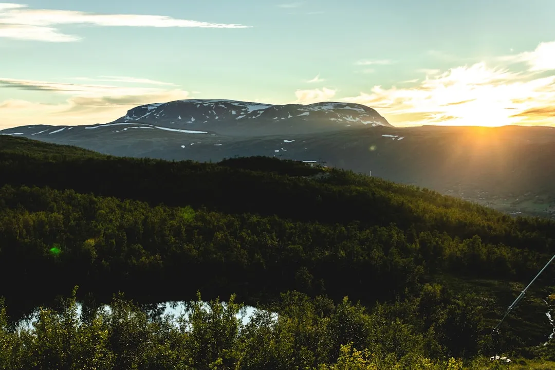
Preikestolen, known internationally as Pulpit Rock, is perhaps the most famous natural landmark in Norway. This massive granite cliff rises 604 metres sheer above the crystal-blue waters of the Lysefjord in the Ryfylke region. The plateau itself is remarkably flat, measuring approximately 25 by 25 metres, appearing as if it were carved by a giant’s hand to provide the ultimate viewing platform over the glaciated landscape of Fjord Norway. Located near the city of Stavanger, this 7.6-kilometre return journey attracts hundreds of thousands of visitors annually, yet its raw, unfenced edges and dramatic verticality ensure it remains a humbling wilderness experience. The trail is a masterclass in Norwegian terrain, transitioning from lush coastal forests and marshy plateaus to rugged stone staircases hand-built by Nepalese Sherpas, culminating in a ridge walk that offers some of the most vertigo-inducing views on the planet.
- Distance: 7.6 km return
- Duration: 4–5 hours
- Elevation Gain: 350 m
- Difficulty: Moderate
- Highest Point: 604 m (The Plateau)
- Location: Strand, Rogaland, Norway
- Closest City: Stavanger
- Season: May to September (Peak season)
Overview
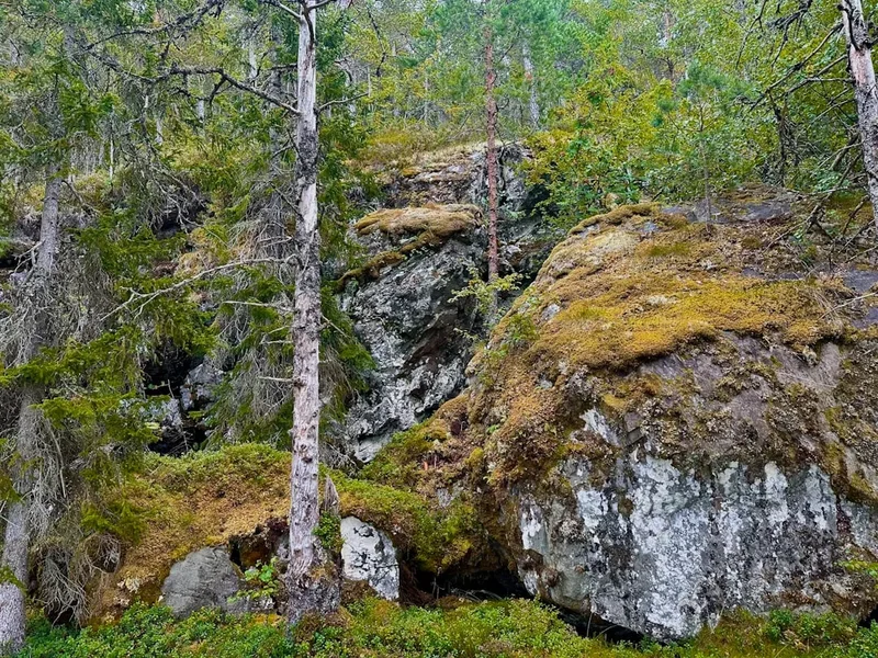
The journey to Preikestolen is more than just a walk to a viewpoint; it is a transition through the diverse ecological zones of the Norwegian highlands. The trail begins at the Preikestolen Mountain Lodge (Preikestolen Fjellstue), situated at approximately 270 metres above sea level. From here, the path ascends through a series of steep climbs and levelling plateaus, providing a rhythmic hiking experience that balances physical exertion with moments of scenic repose. The landscape is dominated by ancient granite bedrock, scoured and polished by the retreat of massive glaciers at the end of the last ice age. Along the way, hikers encounter mountain tarns (small lakes), patches of hardy birch and pine forest, and expansive boulder fields.
What makes Preikestolen unique is the sheer scale of the Lysefjord below. The fjord stretches 42 kilometres into the heart of the mountains, and from the pulpit, one can see the dramatic "U" shape of the valley, a classic hallmark of glacial erosion. Unlike many tourist destinations of this magnitude, there are no safety fences or railings at the edge of the plateau. This is a deliberate choice by Norwegian authorities to preserve the natural beauty and "wild" feel of the site, placing the responsibility for safety squarely on the shoulders of the individual. The experience of sitting on the edge, legs dangling over a 600-metre drop, is a rite of passage for many travellers, though it requires a steady head and a deep respect for the elements.
In recent years, the trail has undergone significant upgrades to handle its popularity. The most notable addition is the extensive stonework completed by Sherpas from Nepal, who have laid thousands of granite blocks to create stable, sustainable stairs through the steepest and most eroded sections of the path. This has made the hike more accessible while protecting the fragile alpine vegetation from the impact of heavy foot traffic. Despite these improvements, the weather remains the ultimate arbiter of the experience. The Lysefjord is notorious for rapid changes in conditions; a sunny morning can quickly transform into a misty, wind-swept afternoon where the fjord disappears entirely behind a veil of grey cloud, only to reappear moments later in a dramatic reveal.
History and Cultural Context
The geological history of Preikestolen dates back approximately 10,000 years to the end of the last ice age. As the massive glaciers that covered Scandinavia began to melt and recede, the pressure release and the movement of ice caused deep fractures in the surrounding mountains. Preikestolen was formed when a large block of granite was pushed outward by the frost-wedging of water in these cracks, leaving the distinctive flat-topped cliff we see today. A deep crack still runs across the base of the plateau; while geological monitoring confirms the site is stable, local folklore jokingly suggests that the day seven brothers marry seven sisters from the Lysefjord region, the plateau will finally fall into the sea.
For centuries, the plateau was known locally as "Hyvlatonnå" (the planed tooth), a name reflecting its sharp, angular appearance from the water. It was not a destination for hikers but rather a landmark for sailors and farmers navigating the fjord. Its transformation into a world-renowned tourist destination began around 1900. Thomas Peter Randulff, a bank manager from Stavanger, was travelling on the steamboat "Oscar II" in the Lysefjord when he spotted the unusual rock formation. Intrigued, he set out to find it from the landward side. His successful trek marked the beginning of the modern era of exploration for the site. Shortly after, the Stavanger Trekking Association (STF) began promoting the route, and the first mountain lodge was established in the 1940s.
In modern popular culture, Preikestolen gained global fame as a filming location for the climax of the movie Mission: Impossible – Fallout. Although the film set the scene in Kashmir, the unmistakable granite face of Pulpit Rock provided the backdrop for the high-stakes helicopter chase and cliffside fight. This "Hollywood effect" has significantly boosted visitor numbers, cementing the trail's status as a global bucket-list item. Despite the crowds, the site remains a point of immense national pride for Norwegians, representing the "Friluftsliv" (open-air life) philosophy—the cultural belief that spending time in nature is essential for the human spirit.
Want more background? Read extended notes on history and cultural context → Learn more
Seasonal Highlights and Weather Reality
The experience of Preikestolen changes dramatically with the seasons, and choosing the right time to visit is crucial for both safety and enjoyment. The official hiking season runs from May to September, when the days are long and the trail is generally free of snow and ice.
Summer (June to August): This is the peak season. Expect long daylight hours—in late June, it barely gets dark at all. The weather is at its most stable, with temperatures ranging from 10°C to 20°C, though it can feel much colder on the exposed plateau. This is also the busiest time; the trail can feel crowded, and you may have to wait in line for the iconic photo at the edge of the rock. To avoid the largest crowds, many hikers start very early (before 6:00 AM) or late in the afternoon to catch the "golden hour" light.
Shoulder Seasons (May and September): These months offer a quieter experience. In May, you may still encounter patches of melting snow and muddy sections, but the waterfalls in the fjord are at their most powerful. September brings crisp air and the beautiful autumn colours of the mountain heather and birch trees. However, the weather becomes more unpredictable, and the window of daylight begins to shrink rapidly.
Winter (October to April): Hiking to Preikestolen in winter is a serious undertaking and is generally not recommended for those without significant alpine experience. The trail becomes covered in deep snow and, more dangerously, thick sheets of "black ice" on the granite steps. Strong winds and fog can make navigation difficult. During this period, it is highly recommended to go with a professional guide who can provide crampons, headlamps, and expert navigation. The road to the trailhead is kept open, but the hike can take twice as long as in summer.
Regardless of the season, the "Weather Reality" of the Lysefjord is that it creates its own microclimate. It is common to experience "four seasons in one day." Rain is frequent, and the wind can be powerful enough to make standing near the edge of the cliff dangerous. Always check the local forecast (Yr.no) specifically for the Preikestolen mountain area, not just Stavanger, before setting out.
Recommended Itinerary

Preikestolen Day Hike Progression
Early Morning: The Ascent Begins
- 0.0 km - 1.0 km: Start at the Preikestolen Mountain Lodge trailhead. The first section is a relatively steep climb on a wide, gravelled path through a pine forest. This serves as a quick warm-up for the legs.
- 1.0 km - 1.5 km: The trail levels out as you reach a marshy plateau. Wooden boardwalks protect the fragile bog cotton and heather. This is a good place to catch your breath and look back toward the lakes near the lodge.
- 1.5 km - 2.5 km: The "Sherpa Stairs." This is the most physically demanding part of the hike. You will ascend a long series of stone steps built into a steep gully. The gradient is consistent, and the footing is secure, but it will get your heart rate up.
Mid-Morning: The High Plateau
- 2.5 km - 3.2 km: After clearing the stairs, you emerge onto a high alpine plateau. The terrain becomes more rugged and rocky. You will pass several small mountain tarns (Tjødnane) which are popular spots for a quick dip on hot summer days.
- 3.2 km - 3.5 km: The trail begins to hug the side of the mountain. You will catch your first glimpses of the Lysefjord far below to your right. The path here is well-marked with red "T"s painted on the rocks.
- 3.5 km - 3.8 km: The Final Approach. The path narrows as it winds around a cliff face. There is a sturdy wooden walkway in one section where the rock drops away. As you round the final corner, the massive flat surface of Preikestolen suddenly comes into view.
Midday: At the Pulpit
- The Plateau: Spend time exploring the 25x25 metre surface. Most people congregate near the front edge, but the views from the higher rocks behind the plateau are equally spectacular and offer a better perspective of the "crack" in the rock.
- Lunch Break: Find a spot away from the edge to enjoy your packed lunch. The view extends down the fjord toward the Atlantic and inland toward the high peaks of the Lyseheiene mountains.
- Photography: If you want the classic "sitting on the edge" photo, be prepared to wait your turn politely. Remember that wind gusts can be sudden; stay well back from the edge if conditions are gusty.
Afternoon: The Descent
- 3.8 km - 7.6 km: Return via the same route. While the descent is easier on the lungs, it can be taxing on the knees, especially on the Sherpa stairs. Take your time and watch your footing, as the granite can be slippery if damp.
- Post-Hike: Arrive back at the Mountain Lodge. There is a café and restaurant here where you can celebrate your achievement with a local Norwegian beer or a hot coffee.
Important Notes:
- Total time is usually 4–5 hours, but allow 6 hours if you want to spend significant time at the top.
- The trail is very well-marked; following the red "T" symbols is essential, especially in fog.
- There are no toilets or water sources on the trail itself; use the facilities at the trailhead.
- In peak summer, the trail can be very busy between 10:00 AM and 2:00 PM.
Planning and Bookings
Book Your Trip
Everything you need to plan your journey
Accommodation
Find places to stay near Stavanger
Flights
Search flights to Stavanger
Essential Preparation
While Preikestolen is classified as a "moderate" hike, it should not be underestimated. The terrain is uneven, and the weather can turn a simple walk into a survival exercise. Physical fitness requirements are modest—if you can walk for four hours with some steep uphill sections, you will be fine—but proper footwear is non-negotiable. Sneakers or fashion shoes are unsuitable and lead to many of the injuries reported on the trail each year.
Logistically, Stavanger is the primary base for this hike. From Stavanger, you have two main options: taking a dedicated "Pulpit Rock" bus (which runs frequently during the summer) or driving yourself. The drive takes about 40 minutes from the city centre via the Ryfylke Tunnel (Ryfast), which is the world's longest and deepest underwater road tunnel. There is a large parking area at the trailhead, but it fills up early in the morning during July and August. Booking your bus ticket in advance is highly recommended during the peak season to ensure a seat.
Trail Accommodation
Because Preikestolen is a day hike, there is no accommodation on the trail itself. However, there are several options at the trailhead and in the surrounding area.
Preikestolen BaseCamp: Located right at the start of the trail, this complex offers several types of accommodation:
- Preikestolen Fjellstue (Mountain Lodge): Modern, comfortable rooms with en-suite bathrooms and a high-quality restaurant.
- Preikestolen Hostel: A more budget-friendly option with shared facilities.
- Vatnebu: Simple cabins for groups or families.
- Hikers' Camp: Permanent canvas tents (glamping style) available during the summer months.
Camping: Under Norway’s "Allemannsretten" (Right to Roam), you are allowed to camp in the wild as long as you are at least 150 metres away from inhabited houses or cabins. However, due to the extreme popularity of Preikestolen, there are specific restrictions immediately around the trail to prevent erosion and pollution. If you wish to camp, you must find a spot well away from the main path and the plateau itself. There are no facilities (water or toilets) for wild campers, so you must be fully self-sufficient and follow Leave No Trace principles strictly.
Stavanger: Most visitors choose to stay in Stavanger, which offers a full range of hotels, hostels, and Airbnb options. This allows you to enjoy the city’s vibrant food scene and historic "Old Stavanger" (Gamle Stavanger) district after your hike.
Required Gear
- Hiking Boots: Sturdy, waterproof boots with good ankle support and a "Vibram" or similar high-grip sole. The granite can be incredibly slick when wet.
- Waterproof Jacket: A high-quality shell (Gore-Tex or similar) is essential. Even if the sun is shining at the start, rain is always a possibility.
- Layered Clothing: Use the "three-layer system." A moisture-wicking base layer (merino wool is best), an insulating mid-layer (fleece or light down), and your waterproof shell. Avoid cotton, as it stays cold and heavy when wet.
- Backpack: A 20–30 litre daypack with a rain cover.
- Navigation: While the trail is well-marked, having an offline map (like Norgeskart or Maps.me) on your phone is a good safety measure.
- First Aid Kit: Include blister plasters (Compeed), antiseptic wipes, and any personal medications.
What to Bring
- Water: At least 1.5 to 2 litres per person. While there are streams and lakes, the high volume of hikers means the water is not always safe to drink without treatment.
- Food: A substantial packed lunch and high-energy snacks (nuts, chocolate, energy bars). There are no food outlets once you leave the trailhead.
- Sun Protection: Sunscreen, sunglasses, and a hat. The sun can be very intense at higher altitudes, even in cool weather.
- Power Bank: Cold weather and frequent photo-taking will drain your phone battery quickly.
- Headlamp: Essential if you are planning a sunrise or sunset hike, or as an emergency backup in case you are delayed.
- Trash Bag: To carry out all your waste, including fruit peels and tissues.
Permits

One of the great things about hiking in Norway is that there are no permits required to hike to Preikestolen. Access to nature is considered a fundamental right. However, there are costs associated with the infrastructure and transport that you need to budget for.
Parking Fees: If you are driving your own vehicle, you must pay for parking at the Preikestolen BaseCamp. As of 2024, the fee is approximately 250 NOK (Norwegian Krone) for a car for the day. This fee goes directly toward the maintenance of the trail, the Sherpa stairs, and the emergency rescue services. The parking uses an automated camera system (EasyPark or similar), so you can pay via an app or at a machine before you leave.
Transport Costs:
- Bus from Stavanger: A return ticket on the "Pulpit Rock Bus" typically costs between 400 and 600 NOK depending on the provider and how far in advance you book.
- Tunnels: If driving, be aware that the Ryfylke Tunnel is a toll road. The cost is approximately 160 NOK each way for a standard vehicle (electric vehicles often get a discount). Tolls are collected automatically via the "AutoPass" system; if you have a rental car, the cost will be billed to your rental agency.
Guided Hikes: While not a permit, if you choose to go with a guide (highly recommended in winter or for sunrise), expect to pay between 900 and 1,500 NOK per person. This usually includes transport, equipment (like spikes or poles), and a professional guide.
Other Activities in the Area
The Ryfylke region and Stavanger offer a wealth of activities that complement a trip to Preikestolen:
- Lysefjord Sightseeing Cruise: If you want to see Preikestolen from below, take a boat trip from Stavanger. Seeing the massive cliff towering 600 metres above the boat provides a completely different perspective on its scale. Most cruises also stop at "Vagabond’s Cave" and Hengjanefossen waterfall.
- Kjeragbolten: For those seeking a more challenging hike, Kjerag is located further into the Lysefjord. It is famous for the "Bolten"—a boulder wedged in a mountain crevice 1,000 metres above the fjord. It is a much tougher 6–8 hour hike.
- Flørli 4444: Visit the roadless village of Flørli and climb the world’s longest wooden staircase—4,444 steps following an old water pipeline up the mountainside.
- Stavanger Old Town (Gamle Stavanger): Explore the best-preserved settlement of wooden houses in northern Europe, with over 170 white-painted cottages dating from the 18th and 19th centuries.
- Norwegian Petroleum Museum: A surprisingly engaging museum in Stavanger that explains the industry that built modern Norway, featuring interactive exhibits and offshore rig models.
- Sola Beach: A stunning stretch of white sand beach near Stavanger, perfect for a post-hike swim or a sunset walk.
Safety and Conditions
Pre-Departure Checks:
- Check the weather forecast on Yr.no. Look for "Preikestolen" specifically. If the forecast predicts high winds (over 12 m/s) or heavy fog, consider postponing.
- Check the Preikestolen 365 Facebook page or local news for trail alerts. In early spring, the trail may be closed due to ice or avalanche risk.
- Ensure your phone is fully charged and you have downloaded offline maps.
The "No Fence" Policy: Norway maintains a policy of personal responsibility. There are no fences at Preikestolen. Every year, there are reports of people taking unnecessary risks for photos. Do not stand on the edge if it is windy, and never sit with your legs over the edge if you feel dizzy or unsure. The granite can be slippery even when dry due to the "polishing" effect of millions of footsteps.
Hypothermia and Exposure: Even in summer, the temperature at the top can be 5–10 degrees lower than at the trailhead. Combined with wind chill and rain, hypothermia is a genuine risk if you are not wearing the correct layers. If you get wet and the wind picks up, your body temperature will drop rapidly.
Rescue Services: The Norwegian Volunteer Rescue Service (Norsk Folkehjelp) operates in the area. However, a helicopter rescue is only possible in certain weather conditions. If you are injured, it may take hours for a ground team to reach you. Always carry a basic first aid kit and enough warm clothing to survive a few hours of waiting in the cold.
Crowd Management: On busy days, the sheer number of people can be a safety hazard. Be patient on the Sherpa stairs and allow faster hikers to pass. If the plateau is overcrowded, find a quieter spot on the rocks above to enjoy the view.
Side Trips and Points of Interest
The "Hill of the Sun": Just before you reach the main plateau, there is a path that leads up to the higher ground behind Preikestolen. This area is often much quieter and provides a "bird's eye view" of the plateau itself. From here, you can see the famous crack that separates the pulpit from the rest of the mountain, and you can get photos of the plateau with the fjord in the background without other people in your shot.
Tjødnane Lakes: These three small mountain lakes are located about two-thirds of the way up the trail. In the height of summer, the water can be surprisingly warm. Many locals bring swimwear and take a dip on the way back down to cool off. The flat rocks around the lakes are also the best place for a picnic if the wind at the top is too strong.
Hengjanen Viewpoint: For those with extra energy, there is a less-travelled path that branches off toward Hengjanen. This offers a view of the Lysefjord looking back toward the mouth of the fjord and the islands of Ryfylke. It is a great way to escape the crowds for 30 minutes.
The Old Trail: Before the Sherpa stairs were built, the trail followed a different, more eroded route. You can still see sections of this old path. While it is not recommended for general hiking anymore, it provides an interesting look at how much work has gone into making the current trail sustainable.
Leave No Trace
With over 300,000 visitors a year, the impact on the Preikestolen environment is immense. To keep this trail beautiful and open for future generations, every hiker must adhere to the Leave No Trace principles.
Your responsibility as a walker:
- Pack it in, pack it out: This includes everything. Orange peels, banana skins, and nut shells do not decompose quickly in the cold alpine environment and are an eyesore. Carry a small bag for your trash.
- Stay on the path: The Sherpa stairs and boardwalks were built for a reason. Stepping off the path to avoid a puddle crushes the fragile mosses and heather, leading to wider trails and more erosion.
- Respect the wildlife: You may see sheep grazing near the trailhead or birds of prey circling the fjord. Do not feed them or disturb them.
- Toilet etiquette: There are no toilets on the trail. Use the facilities at the BaseCamp before you start. If you are caught short, move at least 50 metres from the trail and any water sources, bury your waste, and pack out your toilet paper in a sealed bag.
- No Drones: While not strictly banned in all areas, drones are highly discouraged at Preikestolen due to the noise pollution and the privacy of other hikers. In peak season, they are often banned to prevent accidents in the crowded airspace.
- Keep it quiet: People come to the mountains to hear the wind and the birds, not your portable speaker. Use headphones if you want to listen to music.