Preikestolen (Pulpit Rock) - Norway’s Iconic Granite Plateau
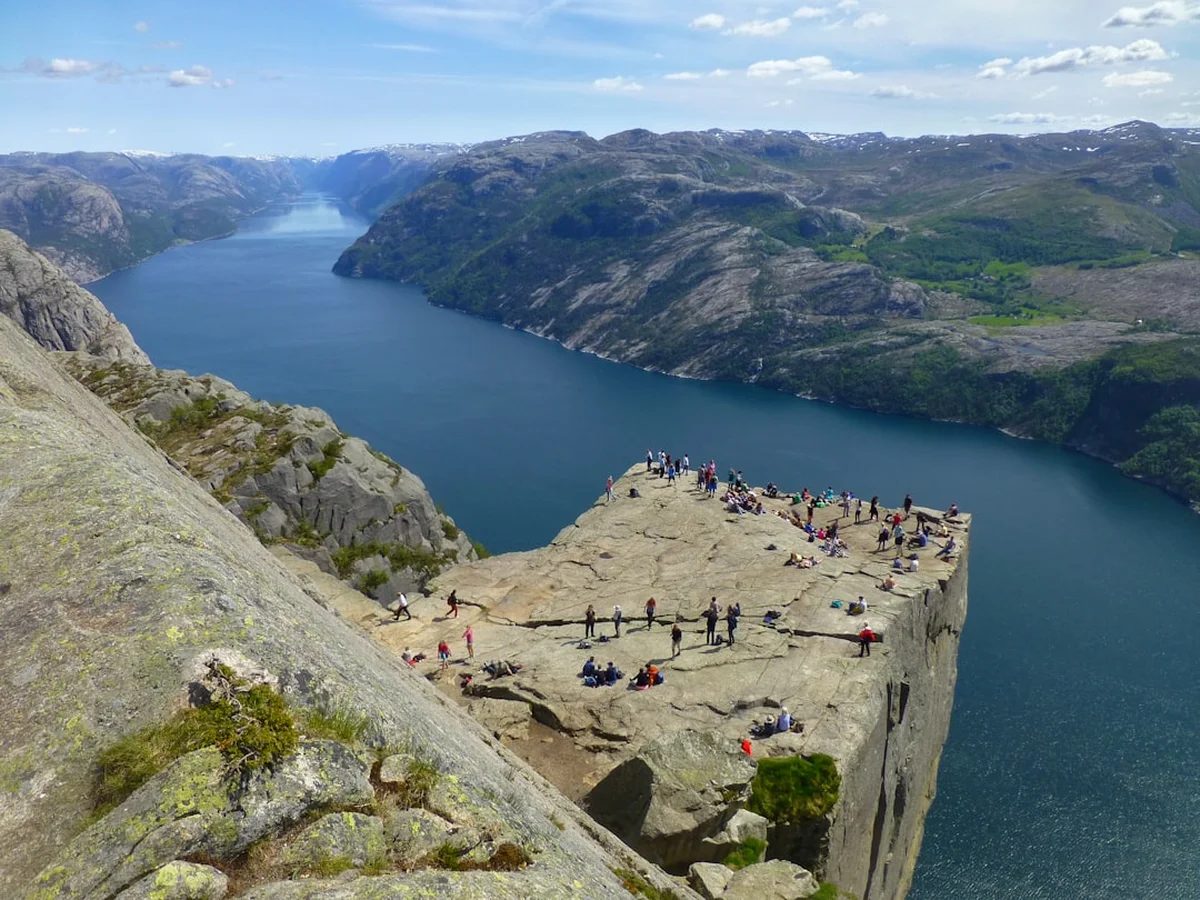
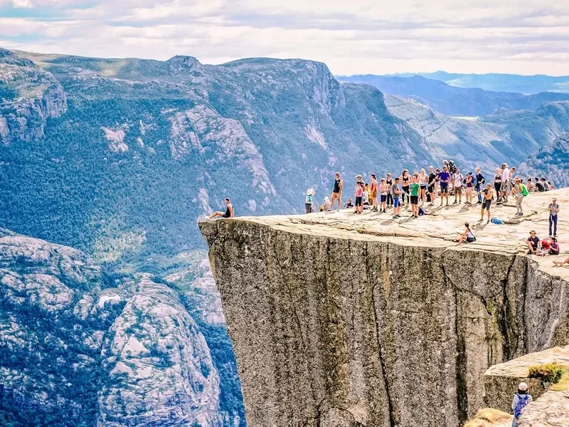
Preikestolen, known internationally as Pulpit Rock, is arguably Norway’s most famous natural landmark. Perched 604 metres above the deep blue waters of the Lysefjord, this massive square plateau offers a perspective of the Scandinavian wilderness that is both humbling and exhilarating. The trail to the summit is an 8-kilometre round trip that has been meticulously upgraded by Nepalese Sherpas to handle the hundreds of thousands of visitors who make the pilgrimage each year. Located in the Ryfylke region near the city of Stavanger, Preikestolen is more than just a hike; it is a cultural touchstone of Norwegian outdoor life, embodying the national philosophy of "friluftsliv"—the deep-seated urge to be outdoors and connected with nature.
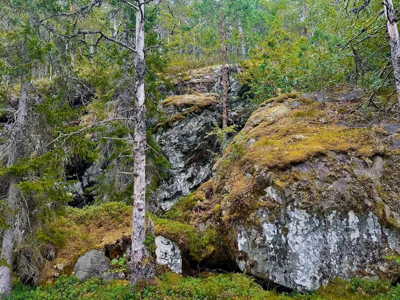
The journey to the top involves a moderate ascent through a varied landscape of pine forests, marshlands, and steep granite stairs. While the destination is the primary draw, the route itself provides a masterclass in glacial geology, showcasing the raw power of the ice sheets that carved these fjords over ten millennia ago. From the trailhead at Preikestolen BaseCamp to the final, breathtaking walk along the cliff’s edge, the experience is designed to build anticipation. It is a walk that rewards physical effort with one of the most photographed views on the planet, yet it retains a sense of wild unpredictability dictated by the shifting Atlantic weather systems that sweep across the Norwegian coast.
- Distance: 8.0 km return
- Duration: 4–5 hours
- Elevation Gain: 500 m
- Difficulty: Moderate
- Best Time: May to September
- Closest City: Stavanger
- Highest Point: 604 m above sea level
- Trailhead: Preikestolen Parking (GPS: 58.9822, 6.1767)
Overview
The Preikestolen trail is a quintessential Norwegian day walk, balancing accessibility with genuine mountain terrain. The path begins at approximately 270 metres above sea level and climbs to the plateau at 604 metres. While the net elevation gain is roughly 334 metres, the undulating nature of the terrain means hikers will actually climb a total of 500 metres over the course of the journey. The trail has seen significant investment in recent years, particularly the installation of "Sherpa steps"—massive stone staircases hand-built by mountain experts from Nepal. these steps have transformed what was once a muddy, eroded scramble into a sustainable, well-defined route that protects the surrounding ecosystem while making the climb manageable for a wide range of fitness levels.
The walk is divided into several distinct phases. It begins with a steep initial climb through a lush forest of pine and birch, where the air is thick with the scent of resin and damp earth. This is followed by a flatter section across a plateau of marshland, where wooden boardwalks prevent hikers from sinking into the peat. The final third of the hike is the most dramatic, as the trees thin out and the landscape becomes dominated by grey granite and hardy alpine vegetation. Here, the trail hugs the side of the mountain, offering the first glimpses of the Lysefjord far below. The final approach to the plateau involves walking along a wide ledge with a vertical drop on one side, a section that provides a thrilling introduction to the scale of the cliff face.
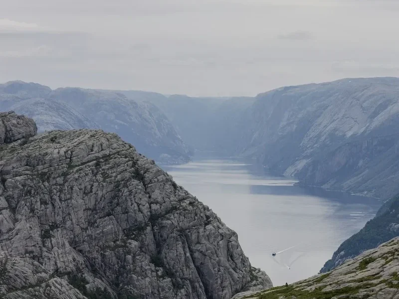
Weather is the defining variable of the Preikestolen experience. On a clear day, the visibility extends for kilometres down the Lysefjord, revealing the winding waterway and the distant peaks of the Ryfylke mountains. However, the region is prone to sudden mists and low-hanging clouds that can swallow the plateau in seconds. Many hikers find the "mystical" version of Preikestolen—where the rock seems to float in a sea of white cloud—just as compelling as the clear-sky panorama. Regardless of the conditions, the sheer verticality of the 604-metre drop is a physical sensation that stays with visitors long after they have descended. It is a place where the scale of the natural world is impossible to ignore.
History and Cultural Context
The geological history of Preikestolen dates back approximately 10,000 years to the end of the last Ice Age. As the massive glaciers that covered Scandinavia began to melt and retreat, they carved out the deep, narrow fjords that define the Norwegian coastline. Preikestolen was formed when a massive block of granite was fractured by the pressure of the ice and the subsequent expansion of freezing water in the rock's cracks. The result was a remarkably flat, square plateau that looks almost man-made in its precision. The famous "crack" that runs across the base of the plateau is a reminder of this ongoing geological process; while scientists monitor it closely, they assure the public that the rock is stable for the foreseeable future.
Despite its ancient origins, Preikestolen remained largely unknown to the wider world until the late 19th century. It was "discovered" as a tourist destination around 1900 by Thomas Peter Randulff, a local bank manager and outdoor enthusiast. While travelling on the steamship "Oscar II" in the Lysefjord, he spotted the unusual rock formation from below and was determined to find a way to the top. His successful ascent marked the beginning of Preikestolen’s journey from a local curiosity to a global icon. In 1949, the Stavanger Turistforening (Stavanger Trekking Association) began marking the trail and promoting the site, though it remained a relatively niche destination for several decades.
In the 21st century, Preikestolen’s popularity exploded, fueled by social media and its appearance in popular culture—most notably as the filming location for the climactic fight scene in "Mission: Impossible – Fallout." Today, it attracts over 300,000 visitors annually. This surge in popularity has necessitated a delicate balance between preserving the wild character of the site and providing the infrastructure needed to keep hikers safe. The Norwegian government and local authorities have resisted installing safety fences or railings on the plateau itself, adhering to the principle that nature should remain as untouched as possible and that individuals must take responsibility for their own safety in the mountains.
Want more background? Read extended notes on history and cultural context → Learn more
Seasonal Highlights and Weather Reality
The main hiking season for Preikestolen runs from May to September. During these months, the trail is generally free of snow, the days are long, and the transport links from Stavanger are at their most frequent. June and July offer the "Midnight Sun" effect, where the twilight lingers for hours, allowing for late-evening hikes that avoid the midday crowds. However, this is also the peak tourist season, and the trail can become very busy, particularly on weekends with good weather.
Autumn (October) can be a spectacular time to visit, as the birch trees turn a brilliant gold and the air becomes crisp and clear. However, the weather becomes significantly more unstable, with increased rainfall and the possibility of early snow at higher elevations. The granite rocks can become extremely slippery when wet, requiring extra caution on the descent. By November, the trail enters its winter phase, which lasts until April. During this time, the path is often covered in deep snow and ice, and the daylight hours are very short.
Winter hiking to Preikestolen is a serious undertaking and is only recommended for experienced hikers with the proper equipment, such as crampons and ice axes. Many local operators offer guided winter hikes, which are highly recommended for those unfamiliar with Norwegian mountain conditions. The plateau in winter is a stark, monochromatic world of white and grey, offering a completely different aesthetic to the summer experience. Regardless of the season, hikers must be prepared for the "four seasons in one day" phenomenon. A sunny start at the trailhead is no guarantee of clear conditions at the summit, and temperatures on the plateau are typically 5–10 degrees Celsius cooler than in Stavanger.
Recommended Itinerary
Preikestolen Day Hike Itinerary
Early Morning: Departure and Arrival
- 07:00 – 08:00: Depart Stavanger via the Ryfylke tunnel (Ryfast), the world's longest and deepest underwater road tunnel.
- 08:15: Arrive at the Preikestolen Parking area. Early arrival is crucial to secure a parking spot and beat the large tour buses.
- 08:30: Final gear check at the trailhead. Use the facilities at Preikestolen BaseCamp, as there are no toilets on the trail.
- 08:45: Begin the ascent. The first kilometre is one of the steepest sections, designed to get the heart rate up immediately.
Morning: The Ascent
- 09:15: Reach the first plateau. The trail levels out briefly, providing views back towards the Stavanger peninsula.
- 09:45: Enter the "Sherpa Steps" section. This is a steady climb up well-laid stone stairs through a boulder field.
- 10:15: Arrive at Neverdalstjern, a beautiful mountain lake. This is an excellent spot for a short break and a drink of water.
- 10:45: The final climb. The trail becomes more rugged as you move onto the open granite slopes above the treeline.
- 11:15: The "Cliff Walk." The path narrows and follows the edge of the mountain, offering spectacular views of the Lysefjord.
Midday: The Plateau Experience
- 11:30: Arrive at Preikestolen plateau. Take time to explore the 25x25 metre flat surface.
- 12:00: Lunch on the plateau. Find a spot away from the edge to enjoy your packed meal while taking in the 604-metre drop.
- 12:30: Optional: Climb the small hill behind the plateau (the "Pulpit's Back") for a higher perspective and a classic photo of the rock itself.
- 13:00: Begin the descent. The return journey follows the same path but requires careful footwork on the stone steps.
Afternoon: Descent and Relaxation
- 14:30: Pass Neverdalstjern again. The descent is often harder on the knees than the ascent; take your time.
- 15:30: Arrive back at the Preikestolen BaseCamp.
- 15:45: Visit the souvenir shop or enjoy a well-earned coffee or meal at the mountain lodge.
- 16:30: Depart for Stavanger, perhaps stopping at the "Sverd i fjell" (Swords in Rock) monument on the way back into the city.
Important Notes:
- The total time of 4–5 hours is a comfortable pace for most hikers; faster walkers can complete it in 3 hours.
- There is no water available on the trail except for the lakes (treatment recommended).
- The trail is well-marked with red "T" painted on rocks and signposts at key junctions.
- Mobile phone coverage is generally good along the entire route.
- In peak season, expect to share the plateau with many other people.
Planning and Bookings
Book Your Trip
Everything you need to plan your journey
Accommodation
Find places to stay near Stavanger
Flights
Search flights to Stavanger
Essential Preparation
Preikestolen is a moderate hike, but it should not be underestimated. A basic level of cardiovascular fitness is required to manage the 500-metre elevation gain. If you can walk for two hours on an incline, you can manage this trail. Logistics are relatively straightforward due to the proximity to Stavanger. Most hikers base themselves in Stavanger, which offers a wide range of accommodation from hostels to high-end hotels. The city is well-connected by air (Sola Airport) and rail.
The most critical logistical element is transport. Since the opening of the Ryfast tunnel system, the journey from Stavanger to the trailhead is a simple 40-minute drive. If you do not have a rental car, several "Pulpit Rock" bus shuttles operate from the city centre and the bus terminal. These should be booked in advance during the summer months to ensure a seat. If driving, be aware that the parking fee at the trailhead is significant (approximately 250 NOK) and contributes to the maintenance of the trail and facilities.
Trail Accommodation
This is a day hike requiring no overnight accommodation on the trail itself. Camping is generally discouraged in the immediate vicinity of the trail to protect the environment, although Norwegian "Right to Roam" laws do allow for wild camping at least 150 metres from inhabited houses and outside of specifically restricted areas. However, for the best experience, hikers should stay at the trailhead or in Stavanger.
Accommodation Options:
- Preikestolen BaseCamp: Located at the trailhead. Offers a variety of options including a modern mountain lodge, a traditional hostel, and unique "Hikers' Camp" pods. Booking in advance is essential.
- Lilland Hotell: Located in Tau, about 20 minutes from the trailhead. A popular mid-range option for those who want to be closer to the mountain than Stavanger.
- Stavanger City: A vast array of hotels, Airbnbs, and hostels. Staying in the city allows you to enjoy the restaurants and culture of Stavanger after your hike.
- Camping: There are several organised campsites within a 30-minute drive of the trailhead, such as Preikestolen Camping, which offers full facilities for tents and caravans.
Required Gear
- Hiking boots: Sturdy boots with good ankle support and a grippy sole (Vibram or similar) are essential. The granite can be slippery, and the stone steps are uneven.
- Waterproof jacket: A high-quality shell (Gore-Tex or equivalent) is mandatory. Even if the sun is shining, the weather at 600 metres can change in minutes.
- Layered clothing: Use the layering system. A moisture-wicking base layer (merino wool is best), an insulating mid-layer (fleece), and your outer shell. Avoid cotton, which stays cold and heavy when wet.
- Backpack: A 20–30 litre daypack with a rain cover.
- Navigation: While the trail is well-marked, an offline map (like UT.no or Maps.me) is useful for tracking progress.
- First aid: A basic kit including blister plasters (Compeed), antiseptic wipes, and a space blanket.
What to Bring
- Water: At least 1.5–2 litres per person. While there are streams and lakes, the high volume of hikers means the water should be treated before drinking.
- Food: A substantial packed lunch (sandwiches, pasta salad) and high-energy snacks (nuts, chocolate, dried fruit). There is no food available once you leave the trailhead.
- Sun protection: Sunscreen, sunglasses, and a hat. The sun can be surprisingly intense on the open granite plateau.
- Personal items: Tissues, hand sanitiser, and a small bag for your rubbish (everything must be carried out).
- Camera/Phone: For the iconic photos, but ensure you have a power bank as cold weather and GPS use can drain batteries quickly.
- Cash/Card: For the parking fee or a post-hike treat at the BaseCamp.
Permits
One of the great advantages of hiking in Norway is the lack of a permit system for most trails, including Preikestolen. There is no entrance fee to the Lysefjord or the mountain itself, reflecting the Norwegian belief that nature should be accessible to everyone. You do not need to book a time slot or register your hike with any authorities.
Associated Costs:
- Parking: While the trail is free, the parking at the trailhead is managed by a private foundation and costs approximately 250 NOK per day for a standard car. This fee is the primary source of funding for trail maintenance, the Sherpa step projects, and the emergency rescue services.
- Transport: If you are taking the shuttle bus from Stavanger, expect to pay around 300–400 NOK for a return ticket.
- Tunnels: The Ryfast tunnel system is a toll road. The cost is automatically charged to your vehicle's registration (or your rental car agreement) and is approximately 160 NOK each way.
Regulations:
- Drones: The use of drones is strictly regulated. In peak season, drones are often banned to protect the privacy and safety of other hikers. Always check the latest signage at the trailhead.
- Dogs: Dogs are welcome but must be kept on a lead at all times. Be aware that some sections of the trail are steep and may be challenging for smaller or less agile dogs.
- Camping: As mentioned, while the "Right to Roam" exists, camping is restricted in the immediate vicinity of the Preikestolen trail to prevent erosion and pollution. Look for designated areas or stay at least 150 metres away from the path.
Other Activities in the Area
The Ryfylke region and the city of Stavanger offer a wealth of experiences that complement a hike to Preikestolen:
- Lysefjord Sightseeing Cruise: If you have seen the fjord from above, see it from below. Cruises depart from Stavanger and take you directly under Preikestolen, providing a different perspective on its massive scale. You will also see "Hengjanefossen" waterfall and the "Vagabond’s Cave."
- Flørli 4444: For those who love stairs, the village of Flørli (accessible only by boat) features the world's longest wooden staircase—4,444 steps following an old water pipeline up the mountain. It is a gruelling but rewarding alternative to Preikestolen.
- Kjeragbolten: The "big brother" of Preikestolen. A more challenging 6–8 hour hike further down the Lysefjord, famous for the boulder wedged in a mountain crevasse 1,000 metres above the water.
- Stavanger Old Town (Gamle Stavanger): Explore the best-preserved settlement of wooden houses in Northern Europe. Over 170 white wooden buildings dating from the 18th and 19th centuries.
- Norwegian Petroleum Museum: A surprisingly engaging museum in Stavanger that explains the industry that built modern Norway, with excellent interactive exhibits.
- Sola Beach: A beautiful stretch of white sand near the airport, perfect for a relaxing walk or a dip in the North Sea (if you are brave enough) after your mountain adventures.
Safety and Conditions
Pre-Departure Checks:
- Check the weather forecast on Yr.no (the official Norwegian weather service). Look specifically for wind speeds and fog warnings.
- Ensure your phone is fully charged and consider bringing a power bank.
- Tell someone your plans and when you expect to be back.
- Check the "Preikestolen 365" social media pages or local news for any temporary trail closures or warnings.
Mountain Hazards: The most significant danger at Preikestolen is the weather. Fog can roll in with incredible speed, reducing visibility to a few metres. If you lose the trail in the fog, stay put or carefully retrace your steps to the last red "T" marker. The granite surfaces become extremely slick when wet or icy; many injuries on the trail are the result of simple slips and falls on the descent. Proper footwear with deep tread is your best defence.
The Cliff Edge: There are no safety fences on Preikestolen. This is a deliberate choice to maintain the natural beauty of the site. While the plateau is large and flat, the edges are sheer. Be extremely cautious when taking photos, especially in windy conditions. Gusts of wind on the plateau can be powerful enough to knock a person off balance. Never stand near the edge if the wind is strong or gusty.
Rescue Services: In the event of an emergency, call 112. The Norwegian Volunteer Red Cross (Norsk Folkehjelp) operates a rescue station near the trailhead during the peak season. However, a helicopter rescue is weather-dependent and can be very expensive if you do not have adequate travel insurance. Always hike within your limits and be prepared to turn back if the conditions deteriorate.
Physical Strain: Dehydration and exhaustion are common issues. Drink plenty of water and eat regularly. The descent often causes more strain on the joints than the ascent; use trekking poles if you have sensitive knees.
Side Trips and Points of Interest
The "Pulpit's Back" (Hill Climb): Most people stop at the plateau, but if you have a little energy left, follow the faint path that climbs the hill directly behind Preikestolen. From this higher vantage point, you can look down onto the plateau and see the famous "crack" from above. This is also the best spot for the classic "person sitting on the edge" photo, as it allows the photographer to capture the scale of the cliff and the fjord in one frame.
Neverdalstjern Lake: This alpine lake, located about two-thirds of the way up, is more than just a landmark. In the height of summer, the water can be warm enough for a very quick, refreshing dip. It is also a peaceful place to escape the crowds of the main plateau for a few minutes. The reflections of the surrounding granite peaks in the still water are a photographer's dream.
The Zip Line: For those looking for an extra adrenaline rush, there is a zip line located near the Preikestolen BaseCamp (not on the main trail). It offers a fast-paced flight through the forest canopy with views of the surrounding mountains, providing a fun way to end the day after the long hike down.
Base Jumping History: While now strictly regulated and often banned due to the danger to hikers below, Preikestolen has a long history with base jumpers. You may still see the occasional authorised jump during special events. The 604-metre vertical drop makes it one of the most sought-after exit points in the world for extreme sports enthusiasts.
The "Hidden" Caves: Along the lower sections of the trail, there are several small rock shelters and "caves" formed by tumbled boulders. These were historically used by shepherds and hunters for shelter during storms. While not deep, they offer a glimpse into the rugged history of the mountain before it became a tourist destination.
Leave No Trace
Preikestolen is a victim of its own success. With over 300,000 pairs of boots treading the path each year, the environmental impact is significant. As a visitor, you have a responsibility to minimise your footprint and help preserve this landscape for future generations. Norway’s "Allemannsretten" (Right to Roam) is a privilege that relies on mutual respect between the hiker and the land.
Your responsibility as a walker:
- Carry out all rubbish: This includes organic waste like orange peels and banana skins, which decompose very slowly in the cold alpine environment. If you see trash left by others, please pick it up.
- Stay on the path: The Sherpa steps were built to prevent erosion. Walking off-trail destroys fragile alpine vegetation and creates "social trails" that lead to further soil loss and scarring of the landscape.
- Respect the wildlife: You may encounter sheep or local birds. Observe them from a distance and never feed them.
- Use facilities: Use the toilets at the BaseCamp before you start. If you are caught short on the trail, ensure you are at least 50 metres from any water source and bury your waste deeply. Carry out your toilet paper in a sealed bag.
- No drones without permission: Respect the peace and quiet of other hikers. Drones are often seen as a nuisance in this high-traffic area.
- Do not build rock cairns: While it may seem harmless, moving rocks disturbs the soil and can mislead other hikers who rely on official markers for navigation.
The goal is to leave the mountain exactly as you found it—or better. By following these simple rules, you contribute to the sustainability of one of the world's most beautiful hiking destinations.