Trilha do Pico das Prateleiras - A Jewel of the Serra da Mantiqueira
The Trilha do Pico das Prateleiras, or Prateleiras Peak Trail, is a challenging yet immensely rewarding mountain trek located within the Serra da Mantiqueira range in Brazil. This trail is renowned for its unique geological formations, particularly the striking "prateleiras" (shelves or ledges) that give the peak its name, and offers breathtaking panoramic views of the surrounding landscape. It's a journey that tests physical endurance and rewards with unparalleled natural beauty, making it a must-do for experienced hikers and nature enthusiasts visiting the region.
- Distance: 12.0 km round trip
- Elevation Gain: 400 m
- Duration: 8-10 hours
- Difficulty: Challenging
- Best Time: April to September (dry season)
- Closest City: Itamonte, Minas Gerais
- Trailhead Access: Via Itamonte, Minas Gerais. Requires local transport or 4x4 to reach the trailhead.
- Coordinates: -22.3906, -44.6506
Overview
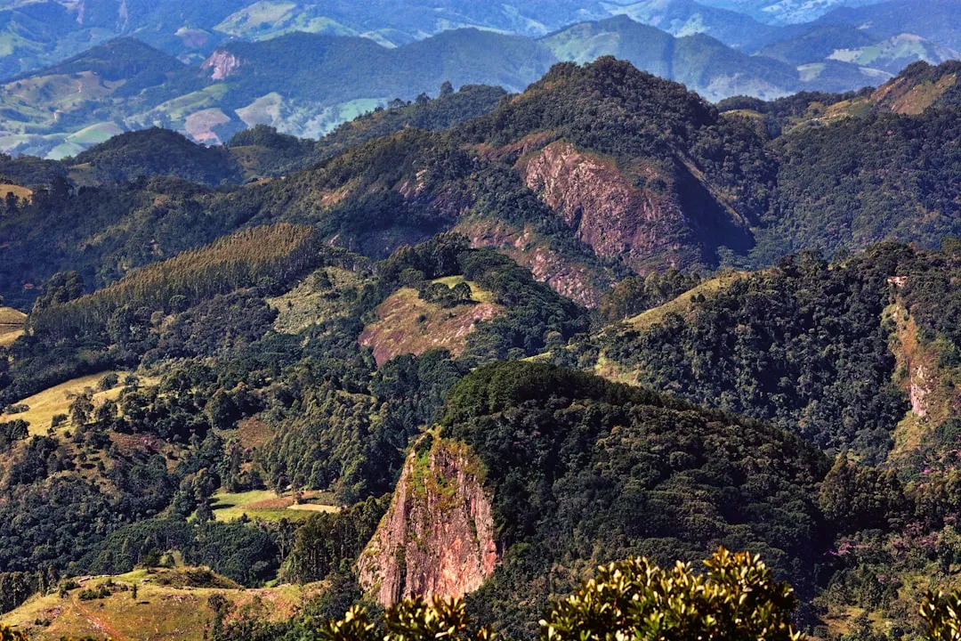
The Trilha do Pico das Prateleiras is a testament to the raw, untamed beauty of Brazil's mountainous interior. Situated in the Serra da Mantiqueira, often referred to as the "Mountains of the Moon," this trail ascends to a summit characterized by its distinctive rock formations that resemble natural shelves or platforms. The hike is not merely a climb; it's an immersion into a unique ecosystem, offering a stark contrast to the lushness often associated with Brazil.
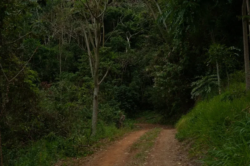
The trail begins with a gradual ascent, winding through varied terrain that can include open fields, rocky paths, and sections of scrubland. As hikers gain altitude, the landscape becomes more exposed, revealing the dramatic geological features that define the Prateleiras. The summit itself is a marvel, with large, flat rock formations providing natural resting spots and incredible vantage points. The panoramic views from the top are expansive, encompassing rolling hills, distant mountain ranges, and the vast Brazilian sky. On a clear day, the visibility can stretch for many kilometres, offering a profound sense of scale and solitude.
This trail is considered challenging due to its steep sections, the uneven terrain, and the potential for rapid weather changes. Hikers need to be well-prepared, both physically and with appropriate gear, to safely navigate the route. The best time to undertake this trek is during the dry season, typically from April to September, when the weather is more stable and the chances of rain are significantly lower. This period also offers clearer skies, enhancing the photographic opportunities and the overall enjoyment of the spectacular vistas.
The journey to the trailhead itself is part of the adventure. Access is usually via the town of Itamonte, from where local transport or a 4x4 vehicle is often necessary to reach the starting point, as road conditions can be rough. This remoteness contributes to the trail's appeal, offering a genuine escape into nature away from the crowds.
History and Cultural Context
The Serra da Mantiqueira region, where the Pico das Prateleiras is located, has a rich history intertwined with indigenous peoples and early Brazilian settlers. For centuries, these mountains served as natural boundaries and routes for indigenous tribes who understood the land's resources and navigated its challenging terrain. The name "Mantiqueira" itself is believed to derive from the Tupi language, possibly meaning "mountains that weep," a reference to the abundant springs and rivers that originate in the range.
During the colonial era and the subsequent development of Brazil, the Serra da Mantiqueira played a role in various economic activities, including agriculture and, in some areas, mining. However, the specific history of the Pico das Prateleiras as a named hiking destination is more recent, evolving with the growth of ecotourism and adventure sports in Brazil. The unique geological formations have always been a natural landmark, but their recognition as a significant hiking objective has grown over the past few decades.
The area around Itamonte and the nearby national parks, such as Itatiaia National Park (though Prateleiras is often accessed from outside its core protected areas depending on the specific route), has become a focal point for those seeking to explore Brazil's diverse natural landscapes. The trail's development has been largely organic, driven by local guides and hiking enthusiasts who have mapped out the most accessible and scenic routes. The cultural context is one of appreciating and preserving these unique geological wonders and the surrounding natural environment, encouraging responsible tourism that respects the delicate ecosystems of the Mantiqueira range.
Seasonal Highlights and Weather Reality
The Trilha do Pico das Prateleiras experiences distinct seasonal variations that significantly impact the hiking experience. Understanding these patterns is crucial for planning a safe and enjoyable trip.
Dry Season (April to September): This is the prime season for hiking the Prateleiras. The weather is generally stable, with significantly less rainfall and lower humidity. Days are often sunny and clear, offering excellent visibility from the summit. Temperatures can be cool, especially at higher altitudes and during the early mornings and evenings, often dropping to around 10-15°C during the day and cooler at night. This period is ideal for those who prefer drier conditions and want to maximise their chances of clear, expansive views. However, even in the dry season, mountain weather can be unpredictable, and sudden changes are always possible.
Rainy Season (October to March): This period is characterized by higher temperatures, increased humidity, and frequent, often heavy, rainfall. While the landscape can appear lush and vibrant, the trail conditions can become challenging, with muddy and slippery sections. Visibility from the summit is often poor due to cloud cover and fog. Thunderstorms are common and can pose a significant risk, especially on exposed ridges and at the summit. Hiking during the rainy season is generally not recommended for casual hikers and requires a higher level of experience, preparedness, and caution. The trail can become hazardous due to flash floods and difficult terrain.
Shoulder Seasons (March/April and September/October): These transitional periods can offer a mix of conditions. You might experience some of the benefits of the dry season with fewer crowds, but there's also a higher chance of encountering residual rain from the wet season or early signs of its return. Weather can be more variable, requiring flexibility in planning and packing.
Regardless of the season, mountain weather is inherently unpredictable. Hikers should always be prepared for a range of conditions, including sudden temperature drops, wind, and rain, even when travelling during the dry season.
Recommended Itinerary
Day Hike: Trilha do Pico das Prateleiras
Early Morning (Approx. 6:00 AM - 7:00 AM): Departure from Itamonte
- Begin your journey from Itamonte. Arrange for local transport or a 4x4 vehicle to take you to the trailhead. The drive can take 1-2 hours depending on road conditions.
- Ensure you have had a substantial breakfast and are carrying sufficient water and snacks.
Morning (Approx. 8:00 AM - 9:00 AM): Arrival at Trailhead and Start of Hike
- Arrive at the designated trailhead. Confirm your route and check any local information available.
- Begin the ascent. The initial part of the trail may be relatively gentle, passing through open fields or light scrub.
- Distance covered: Approximately 1-2 km.
- Elevation gain: Gradual, around 50-100 m.
Late Morning (Approx. 10:00 AM - 12:00 PM): Ascending Through Varied Terrain
- The trail becomes steeper and more rugged. You will encounter rocky sections and potentially some scree.
- The unique geological features of the Serra da Mantiqueira begin to become more apparent.
- Keep an eye on the changing vegetation as you gain altitude.
- Distance covered: Approximately 3-4 km from the start.
- Elevation gain: Significant, accumulating to around 200-250 m from the start.
Midday (Approx. 12:00 PM - 1:00 PM): Reaching the "Prateleiras" and Summit Area
- You will start to see the distinctive "prateleiras" – the rock shelves that give the peak its name.
- The final ascent to the summit area involves navigating these formations. This may require some scrambling or careful foot placement.
- Distance covered: Approximately 5-6 km from the start.
- Elevation gain: Reaching the summit plateau, total gain around 400 m.
Lunch and Exploration (Approx. 1:00 PM - 2:30 PM): Summit Views and Rest
- Enjoy your packed lunch at the summit. Take time to appreciate the 360-degree panoramic views of the Serra da Mantiqueira.
- Explore the unique rock formations safely. Be mindful of the edges and potential for loose rocks.
- This is the highest point of your hike, offering unparalleled vistas on a clear day.
Afternoon (Approx. 2:30 PM - 5:30 PM): Descent and Return to Trailhead
- Begin your descent. The return journey can be faster but requires careful footing, especially on loose or rocky sections.
- Continue to be aware of changing weather conditions.
- Distance covered: Approximately 6-7 km for the descent.
- Elevation loss: Approximately 400 m.
Late Afternoon (Approx. 5:30 PM - 6:30 PM): Arrival at Trailhead and Departure
- Arrive back at the trailhead.
- Meet your pre-arranged transport for the return journey to Itamonte.
Important Notes:
- This is a challenging day hike. Ensure you are physically fit and have adequate hiking experience.
- Start early to allow ample time and avoid hiking in the dark.
- Carry plenty of water (at least 2-3 litres per person) and high-energy snacks.
- The summit can be exposed to wind and sun; wear appropriate layers and sun protection.
- Weather can change rapidly in mountain environments. Always check the forecast before you go and be prepared for rain, even in the dry season.
- Consider hiring a local guide, especially if you are unfamiliar with the area or the trail conditions.
Planning and Bookings
Book Your Trip
Everything you need to plan your journey
Accommodation
Find places to stay near Itamonte
Flights
Search flights to Itamonte
Essential Preparation
The Trilha do Pico das Prateleiras is a demanding hike that requires thorough preparation. Given its location and the nature of the terrain, it's essential to plan logistics well in advance. The closest significant town is Itamonte, which serves as the primary base for accessing the trail. Itamonte offers basic amenities, including accommodation and local guides, but it is a relatively small town, so booking accommodation ahead of time is advisable, especially during peak seasons.
Fitness Requirements: This trail is rated as challenging. Hikers should have a good level of cardiovascular fitness and leg strength. The 400m elevation gain, combined with the 12km distance and potentially uneven terrain, can be strenuous. Regular hiking, running, or cycling in the weeks leading up to the trip will be beneficial. Familiarity with hiking on rocky and uneven surfaces is also advantageous.
Logistics: Access to the trailhead is often the most complex part of the planning. While the coordinates are known, the final approach may require a 4x4 vehicle due to unpaved and potentially rough roads. It is highly recommended to arrange transport with a local operator or guide who is familiar with the route and road conditions. Public transport to Itamonte is available via bus from major cities like Rio de Janeiro or São Paulo, but from Itamonte, private arrangements are usually necessary.
Base Town Information: Itamonte is a small, charming town in Minas Gerais, known for its proximity to natural attractions. It offers a range of accommodation options, from simple guesthouses (pousadas) to more comfortable hotels. There are also local restaurants serving regional cuisine. It's advisable to stock up on supplies, including food and water, in Itamonte before heading to the trailhead, as facilities are scarce in the hiking area.
Trail Accommodation
This is a day hike requiring no overnight accommodation.
Required Gear
- Hiking Boots: Sturdy, waterproof hiking boots with good ankle support are essential. Ensure they are well broken-in to prevent blisters.
- Backpack: A comfortable daypack (20-30 litres) is sufficient for carrying essentials. Ensure it has a good hip belt for stability.
- Waterproof Jacket: A lightweight, breathable waterproof jacket is crucial, as mountain weather can change rapidly, bringing rain and wind.
- Warm Layers: Even during the dry season, temperatures can drop significantly at higher altitudes. Pack a fleece or insulating mid-layer and a hat and gloves.
- Navigation: While the trail is generally well-trodden, a map of the area, a compass, and a GPS device or smartphone with offline maps are highly recommended. Familiarity with using these tools is important.
- Head Torch: Essential in case of unexpected delays or if you start before dawn or finish after dusk. Ensure it has fresh batteries.
- First-Aid Kit: A comprehensive kit including blister treatment, pain relievers, antiseptic wipes, bandages, and any personal medications.
- Sun Protection: High SPF sunscreen, sunglasses, and a wide-brimmed hat are necessary, as the sun can be intense at altitude, especially in open areas.
What to Bring
- Food: High-energy snacks such as nuts, dried fruit, energy bars, and sandwiches. Pack enough for the entire day, plus a little extra in case of emergencies.
- Water: Carry at least 2-3 litres of water per person. Water sources on the trail may be unreliable or require purification. A water filter or purification tablets are a good backup.
- Toiletries: Biodegradable soap, toothbrush, toothpaste, and hand sanitiser. Pack out all used toilet paper.
- Personal Items: Mobile phone (though signal may be limited), power bank for charging devices, camera, and a small amount of cash for any unexpected needs.
- Trekking Poles: Optional but highly recommended for stability on ascents and descents, especially on rocky or uneven terrain.
- Insect Repellent: While not as prevalent as in some other Brazilian regions, insects can be present, especially during warmer months.
Permits
Currently, there are no specific permits required for hiking the Trilha do Pico das Prateleiras itself, as it is often accessed via routes that are not within strictly regulated national park boundaries requiring entry fees or permits for day use. However, it is always advisable to check with local authorities or park visitor centres in Itamonte for the most up-to-date information regarding access regulations, potential park fees if accessing through specific protected areas, or any temporary restrictions that may be in place.
Local Information: It is highly recommended to consult with local guides or the tourist information office in Itamonte. They will have the most current information on trail conditions, any necessary permits, and the best way to access the trailhead safely. They can also advise on the necessity of hiring a guide, which is often beneficial for this challenging route.
Park Entrance Fees: If your chosen route to the trailhead passes through or borders a protected area that charges an entrance fee, you will need to be prepared for that. This is not a universal requirement for the Prateleiras trail but can be a factor depending on the specific access point used.
Guides: While not a mandatory permit, hiring a local guide is strongly recommended for the Trilha do Pico das Prateleiras. Guides possess invaluable knowledge of the terrain, weather patterns, and safety protocols. They can also assist with transport arrangements and ensure you have the most accurate information regarding any access requirements.
Other Activities in the Area
The region surrounding Itamonte and the Serra da Mantiqueira offers a variety of activities for nature lovers and adventure seekers:
- Hiking in Itatiaia National Park: While the Prateleiras trail might be accessed from outside the park, Itatiaia National Park itself offers numerous other hiking trails, including ascents to Agulhas Negras (Black Needles), Brazil's highest peak.
- Exploring Waterfalls: The Mantiqueira range is dotted with beautiful waterfalls. Near Itamonte, you can find cascades like Cachoeira Véu da Noiva (Bride's Veil Waterfall) and Cachoeira do Escorrega (Slippery Waterfall), offering opportunities for swimming and relaxation.
- Canyoning: For the more adventurous, the region offers opportunities for canyoning, descending through ravines and waterfalls with the aid of ropes and specialized equipment.
- Rock Climbing: The granite formations in the Serra da Mantiqueira provide excellent opportunities for rock climbing, with various routes catering to different skill levels.
- Birdwatching: The diverse ecosystems of the Mantiqueira range are home to a rich variety of bird species, making it a prime location for birdwatching enthusiasts.
- Exploring Itamonte Town: Enjoy the local culture, sample regional cuisine at traditional restaurants, and visit local craft shops. The town itself offers a peaceful retreat after a day of hiking.
- Scenic Drives: The roads through the Serra da Mantiqueira offer stunning vistas. Enjoy leisurely drives, stopping at viewpoints to admire the mountainous landscape.
Safety and Conditions
Pre-Hike Checks:
- Weather Forecast: Always check the most up-to-date weather forecast for the Serra da Mantiqueira region, specifically for high altitudes, before and during your hike. Mountain weather can change rapidly and without warning. Websites like Climatempo or local meteorological services can provide detailed forecasts.
- Trail Conditions: If possible, consult with local guides or the tourist information office in Itamonte regarding current trail conditions. Heavy rains can make sections of the trail muddy, slippery, or even impassable.
- Road Conditions: Verify the condition of the access road to the trailhead. If you are arranging your own transport, ensure your vehicle is suitable (4x4 recommended) and that the road is passable.
On-Trail Hazards:
- Terrain: The trail is challenging, with steep ascents, descents, and uneven, rocky surfaces. Loose rocks and scree can be present, increasing the risk of slips and falls. Careful foot placement is essential.
- Weather Changes: Be prepared for sudden shifts in weather. Temperatures can drop significantly, and rain or fog can reduce visibility to near zero, making navigation difficult and increasing the risk of hypothermia.
- Exposure: The summit area and some sections of the trail are exposed, offering little shelter from sun, wind, or rain.
- Navigation: While the main trail is generally discernible, it's easy to get disoriented, especially in fog or if you stray from the marked path. Always carry and know how to use navigation tools.
- Dehydration and Fatigue: The strenuous nature of the hike can lead to dehydration and exhaustion. Pace yourself, drink water regularly, and take breaks when needed.
Recommendations:
- Hike with a Buddy: It is strongly advised not to hike alone. Having a companion can provide assistance in case of an emergency.
- Hire a Local Guide: For this challenging trail, a local guide is highly recommended. They possess intimate knowledge of the route, weather patterns, and safety procedures, significantly enhancing your safety and enjoyment.
- Inform Someone of Your Plans: Let a trusted person know your hiking plans, including your intended route, estimated return time, and who to contact if you do not check in.
- Carry a Fully Charged Mobile Phone: While mobile signal may be intermittent, it's essential for emergencies. A portable power bank is also a good idea.
- Emergency Contact: Know the local emergency contact numbers. In Brazil, the general emergency number is 190 for Police, 192 for Ambulance, and 193 for Fire Department.
Side Trips and Points of Interest
While the Trilha do Pico das Prateleiras is a destination in itself, the surrounding area offers several points of interest and potential short excursions for those with extra time or energy:
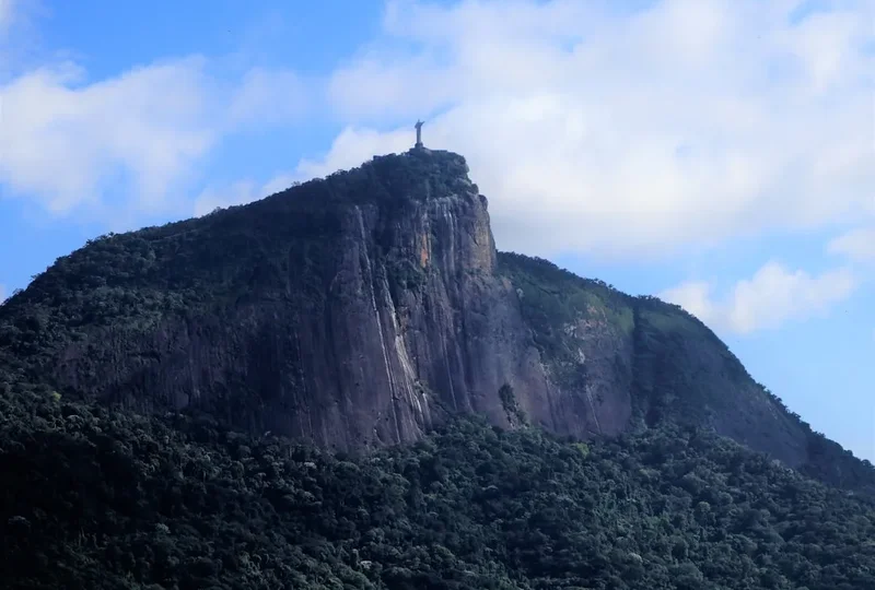
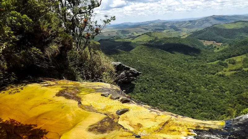
The "Prateleiras" Rock Formations: The primary attraction, these unique geological formations are the reason for the trail's name. They resemble natural shelves or ledges carved by erosion over millennia. Exploring these formations at the summit offers incredible photographic opportunities and a chance to appreciate the raw power of nature. Be cautious when exploring these areas, as some edges can be unstable.
Panoramic Viewpoints: Throughout the ascent and particularly from the summit, numerous viewpoints offer stunning vistas of the Serra da Mantiqueira. These include sweeping views of rolling hills, distant mountain ranges, and the vast expanse of the Brazilian countryside. The changing light throughout the day can dramatically alter the appearance of the landscape, making early morning or late afternoon particularly rewarding for photography.
Unique Flora and Fauna: The trail passes through different ecological zones, showcasing the diverse plant life of the Mantiqueira range. Keep an eye out for endemic species of plants and, if you are lucky, local wildlife. The higher altitudes may feature more hardy, scrub-like vegetation adapted to the exposed conditions.
Nearby Waterfalls: Depending on the specific access route and time available, short detours to nearby waterfalls such as Cachoeira Véu da Noiva or others in the vicinity of Itamonte can be a refreshing addition to the trip. These offer opportunities for a cool dip and a different perspective on the region's natural beauty.
Agulhas Negras (Black Needles): For experienced hikers with more time, the ascent of Agulhas Negras, the highest peak in the Mantiqueira range (2,791 m), is a significant undertaking. While a separate and more demanding hike, it is located within the broader region and is a major draw for mountaineers. Access and conditions for Agulhas Negras are distinct and require separate planning.
Leave No Trace
The Trilha do Pico das Prateleiras traverses a beautiful and ecologically sensitive mountain environment. Adhering to Leave No Trace principles is paramount to preserving its natural state for future visitors and for the health of the ecosystem.
Your responsibility as a hiker:
- Plan Ahead and Prepare: Understand the trail's difficulty, weather conditions, and any local regulations before you go. Pack appropriately and be prepared for all conditions.
- Travel and Camp on Durable Surfaces: Stick to the marked trail. Avoid creating new paths or walking on fragile vegetation, especially in the summit area where the ground cover can be sparse and easily damaged.
- Dispose of Waste Properly: Pack out everything you pack in. This includes all food scraps, wrappers, and any other litter. Use designated toilet facilities if available, or dig a cathole at least 70 metres away from water sources, trails, and campsites, and bury human waste. Pack out used toilet paper.
- Leave What You Find: Do not remove any natural objects, such as rocks, plants, or flowers. Take only photographs and memories.
- Minimize Campfire Impacts: Campfires are generally not permitted on day hikes and are discouraged in sensitive mountain environments. If permitted and necessary, use established fire rings and ensure fires are completely extinguished. For this day hike, campfires are not applicable.
- Respect Wildlife: Observe wildlife from a distance. Do not feed animals, as this can disrupt their natural behaviours and diets, and can be harmful to their health.
- Be Considerate of Other Visitors: Respect the solitude of others. Keep noise levels down, yield to other hikers on narrow sections of the trail, and be courteous.
By following these principles, you help ensure that the Trilha do Pico das Prateleiras remains a pristine and enjoyable experience for everyone.