Pizol Five Lakes Hike - A Masterpiece of the Swiss Alps
The Pizol Five Lakes Hike (5-Seen-Wanderung) is widely regarded as one of the most spectacular and iconic day walks in Switzerland. Located in the Heidiland region of Eastern Switzerland, this 9.5-kilometre route traverses a high-alpine landscape of staggering beauty, linking five distinct mountain lakes, each possessing its own unique character and colour palette. From the deep, crystalline turquoise of the Wildsee to the moody, dark depths of the Schwarzsee, the trail offers a visual symphony of glacial geology and alpine flora. The hike is situated within the UNESCO World Heritage site "Swiss Tectonic Arena Sardona," providing walkers with a front-row seat to the dramatic geological processes that formed the Alps. This is not merely a walk; it is an immersion into a world of jagged peaks, ancient glaciers, and the serene stillness of high-altitude tarns.
- Distance: 9.5 km point-to-point
- Duration: 4–5 hours (walking time)
- Elevation Gain: 600 m
- Elevation Loss: 750 m
- Highest Point: Wildseeluggen (2,493 m)
- Difficulty: Moderate (T3 on the Swiss Alpine Club scale)
- Season: Late June to October (subject to snow conditions)
- Closest City: Sargans / Bad Ragaz
Overview
The Pizol Five Lakes Hike is a high-altitude traverse that captures the essence of the Swiss alpine experience. The journey begins with a series of cable car and chairlift ascents from the valley floor, whisking hikers from the lush meadows of the Rhine Valley to the rugged, rocky heights of the Pizol massif. The trail itself is a well-maintained mountain path that winds through a landscape shaped by the retreat of the Pizol Glacier. The five lakes—Wangsersee, Wildsee, Schottensee, Schwarzsee, and Baschalvasee—serve as the primary waypoints, but the surrounding scenery is equally captivating. To the north, the views extend across the Rhine Valley to the Churfirsten range and the Austrian Alps; to the south, the glaciated peaks of the Glarus Alps dominate the horizon.
What distinguishes this hike from other alpine routes is the sheer variety of the water bodies encountered. The Wangsersee is a classic alpine tarn surrounded by soft meadows. The Wildsee, perhaps the most famous of the five, sits in a stark, lunar landscape of grey scree and rock, its water a milky, vibrant turquoise due to glacial flour. The Schottensee offers a deep, inviting blue, reflecting the surrounding peaks like a mirror. The Schwarzsee (Black Lake) lives up to its name with its dark, mysterious waters, while the final lake, Baschalvasee, is nestled in a greener, more sheltered basin as the trail begins its final descent. The geological context is equally fascinating; the trail crosses the Glarus Overthrust, where older rock layers have been pushed over younger ones, a phenomenon so clearly visible here that it earned the region its UNESCO status.
While the hike is classified as moderate, it requires a good level of fitness and sure-footedness. The terrain is predominantly rocky, with several steep ascents and descents over scree and mountain paths. However, the logistical ease provided by the Pizolbahnen (the local mountain railway system) makes this world-class wilderness accessible to any well-prepared hiker. Whether you are a seasoned mountaineer or a dedicated day-hiker, the Pizol Five Lakes Hike delivers a concentrated dose of Swiss alpine majesty that is difficult to surpass.
History and Cultural Context
The history of the Pizol region is inextricably linked to the geological evolution of the Alps. The Pizol massif is a key component of the Tectonic Arena Sardona, which was inscribed as a UNESCO World Heritage site in 2008. This area is of global significance because it provides the most visible evidence of mountain-building processes (orogeny). Here, the "Glarus Overthrust" is clearly discernible—a massive geological fault where 250-million-year-old Verrucano rock was pushed over much younger, 35-million-year-old Flysch rock. For geologists, this site was instrumental in proving the theory of plate tectonics and the movement of continental plates. As you walk between the lakes, you are literally stepping across millions of years of Earth's history, moving between different geological epochs with every few hundred metres of elevation change.
Culturally, the Pizol has long been a site of alpine farming and transhumance. For centuries, local farmers from Wangs and Bad Ragaz have driven their cattle to these high pastures during the summer months. The name "Pizol" itself is derived from the Romansh language, meaning "high peak," reflecting the linguistic heritage of the Grisons and St. Gallen regions. The development of the Pizol as a tourism destination began in the mid-20th century with the construction of the first chairlifts, transforming the area from a remote grazing ground into a premier destination for skiing in winter and hiking in summer. Despite this modernisation, the region maintains a strong connection to its agricultural roots, and it is common to hear the chime of cowbells in the lower sections of the trail near the Gaffia and Furt stations.
The Pizol Glacier, located just below the Pizol summit, also holds a place in modern environmental history. In 2019, the glacier was the subject of a "funeral march" organised by environmental activists and local residents to mark its near-total disappearance due to climate change. This event highlighted the fragility of the alpine ecosystem and the rapid changes occurring in the high mountains. Today, the Five Lakes Hike serves not only as a recreational route but also as a poignant reminder of the changing climate and the importance of preserving these pristine environments.
Want more background? Read extended notes on history and cultural context → Learn more
Seasonal Highlights and Weather Reality
The hiking season on the Pizol typically runs from late June to mid-October, but this window is strictly dictated by the snowpack. Because the trail reaches an altitude of nearly 2,500 metres, snow can linger on the north-facing slopes and in the shaded basins of the lakes well into July. Conversely, early autumn snowfalls in September can temporarily close the higher sections of the route. It is essential to check the Pizolbahnen website for the official "trail open" status before travelling.
Early Summer (Late June to July): This is the time for alpine wildflowers. The meadows around Wangsersee and Baschalvasee erupt in a riot of colour, with gentians, alpenrose, and edelweiss often visible. However, hikers should be prepared for snow crossings, particularly on the ascent to Wildseeluggen. The lakes are often still partially frozen, creating a dramatic "iceberg" effect in the turquoise waters of the Wildsee.
High Summer (August): This is the most stable period for weather, though afternoon thunderstorms are a common occurrence in the Alps. The temperatures at 2,500 metres are pleasantly cool compared to the heat of the Rhine Valley, making it an ideal escape. This is also the busiest time on the trail, especially on weekends.
Autumn (September to October): Many locals consider this the best time to hike. The air is exceptionally clear, providing the best long-distance views of the Austrian and Glarus Alps. The larch trees in the lower elevations begin to turn gold, and the summer crowds dissipate. However, the days are shorter, and temperatures can drop below freezing at the higher lakes, even in bright sunshine. The "Föhn" wind—a warm, dry wind from the south—can occasionally create very gusty conditions but also brings remarkably high visibility.
Weather in the Pizol region can change with startling rapidity. A clear morning can quickly give way to dense fog or heavy rain. Hikers should always carry waterproof layers and be prepared for a significant temperature drop if the sun disappears behind the peaks.
Recommended Itinerary
Pizol Five Lakes Route Progression
Segment 1: Pizolhütte to Wildsee
- Distance: 1.8 km
- Elevation gain: 270 m
- Time: 1 hour
- Start at the Pizolhütte (2,227 m), accessible via the Wangs cable car and two chairlifts.
- The trail begins with a visit to the first lake, Wangsersee, located just behind the hut.
- Follow the wide, well-marked path as it begins a steady ascent towards the Wildseeluggen.
- The terrain becomes increasingly rocky and alpine as you climb.
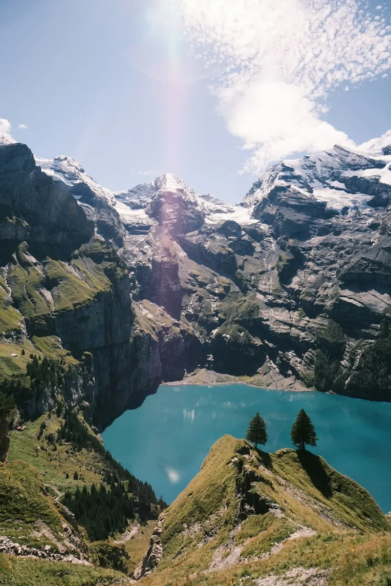
- Reach the Wildseeluggen (2,493 m), the highest point of the hike, where the Wildsee suddenly comes into view.
- The contrast between the grey rock and the milky turquoise water is the visual highlight of the entire trip.
Segment 2: Wildsee to Schottensee
- Distance: 1.2 km
- Elevation loss: 150 m
- Time: 30–45 minutes
- From the Wildseeluggen, the trail descends steeply over rocky terrain towards the Schottensee.
- This section requires careful footwork, especially if the rocks are damp.
- The Schottensee (2,335 m) is a deep blue lake that often holds snow on its banks late into the season.
- The path skirts the eastern shore of the lake, offering magnificent views back towards the Pizol Glacier.
Segment 3: Schottensee to Schwarzsee
- Distance: 2.5 km
- Elevation gain: 150 m, then 200 m loss
- Time: 1 hour 15 minutes
- The trail climbs gently from Schottensee towards the Schwarzplangg ridge.
- From the ridge, you gain a panoramic view of the Glarus Alps, including the Ringelspitz and the Sardona massif.
- A steady descent follows, leading down to the Schwarzsee (2,368 m).
- The Schwarzsee is often frequented by ibex and chamois in the early morning or late afternoon.
- The water here is noticeably darker, reflecting the deep shadows of the surrounding cliffs.
Segment 4: Schwarzsee to Baschalvasee
- Distance: 2.0 km
- Elevation gain: 100 m, then 250 m loss
- Time: 1 hour
- The path climbs one final time towards the Rossstall ridge.
- Look out for the "Steinmännli" (stone cairns) that dot the landscape in this section.
- The descent to Baschalvasee (2,174 m) marks a transition back into greener terrain.
- The Baschalvasee is the smallest of the five lakes and is surrounded by soft alpine grass, making it a popular spot for a final rest.
Segment 5: Baschalvasee to Gaffia
- Distance: 2.0 km
- Elevation loss: 300 m
- Time: 45 minutes
- The final leg of the journey is a continuous descent through alpine pastures.
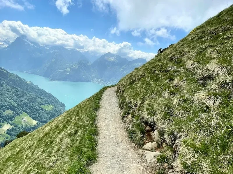
- The trail winds down towards the Gaffia station (1,868 m).
- As you descend, the views of the Rhine Valley and the Liechtenstein mountains open up.
- At Gaffia, take the chairlift and gondola down to Wangs to complete the circuit.
Important Notes:
- The hike is a point-to-point route between the Pizolhütte and Gaffia stations.
- Ensure you check the time of the last descent for the chairlifts (usually between 16:00 and 16:30).
- The direction described (Wangs to Wangs) is the most common, but the hike can also be done starting from Bad Ragaz.
- Walking poles are highly recommended for the steep descents between the lakes.
Planning and Bookings
Book Your Trip
Everything you need to plan your journey
Accommodation
Find places to stay near Sargans
Flights
Search flights to Sargans
Essential Preparation
The Pizol Five Lakes Hike requires careful logistical planning, primarily regarding transport and timing. The hike is located near the town of Sargans, which is a major railway junction. From Zurich, trains run frequently to Sargans (approx. 1 hour). From Sargans station, take Bus 431 to the "Wangs, Pizolbahn" valley station. If you are driving, there is ample parking at the Wangs valley station (fees apply).
Fitness is a key consideration. While the distance is under 10 kilometres, the high altitude and the 600 metres of ascent (combined with significant descent) make it a physically demanding day. Hikers should be comfortable with mountain terrain and have a basic level of alpine experience. It is also vital to check the mountain webcams and weather forecasts on the Pizolbahnen website on the morning of your hike. If visibility is poor, the experience is significantly diminished, and navigation can become difficult in the rocky sections.
Trail Accommodation
This is primarily a day hike, and most visitors return to the valley or stay in nearby Sargans or Bad Ragaz. However, for those wishing to experience a night in the mountains, there are several options near the trailheads.
Mountain Huts and Guesthouses:
- Pizolhütte: Located at the start of the hike (2,227 m). It offers dormitory-style accommodation and private rooms. Booking is essential, especially on weekends. Facilities include a restaurant, sun terrace, and shared bathrooms.
- Berggasthaus Gaffia: Situated at the end of the hike (1,868 m). This traditional mountain inn offers a cosy atmosphere and local Swiss cuisine. It is an excellent option for those who want to start early or finish late.
- Berghotel Furt: Located at the middle station of the Wangs gondola. It offers more hotel-like amenities and is suitable for families.
What is NOT provided: These are mountain guesthouses, not luxury hotels. You will typically need to bring your own silk sleeping bag liner for dormitories. Towels are often not provided in shared rooms. There is no camping allowed anywhere along the Five Lakes trail or in the UNESCO World Heritage area.
Required Gear
- Hiking Boots: Sturdy, high-cut boots with a Vibram-style sole are essential. The terrain is very rocky, and ankle support is necessary for the scree sections.
- Clothing: Use the layering system. Even in summer, a fleece or insulated jacket is needed for the higher elevations. A high-quality waterproof shell (Gore-Tex or similar) is mandatory.
- Trekking Poles: Highly recommended to reduce the impact on knees during the 750 metres of descent.
- Sun Protection: The alpine sun is intense. Bring high-SPF sunscreen, a hat, and category 3 or 4 sunglasses.
- Navigation: While the trail is well-marked with red-and-white paint flashes, a topographic map (1:25,000) or a reliable GPS app with offline maps is recommended.
What to Bring
- Water: Carry at least 2 litres of water. While there are lakes, the water is not treated and may contain runoff from livestock. There are no water fountains along the trail between the huts.
- Food: Bring a packed lunch and high-energy snacks (nuts, chocolate, dried fruit). While there are restaurants at the start and end, there are no facilities on the trail itself.
- First Aid: A basic kit including blister plasters (Compeed), antiseptic wipes, and any personal medications.
- Emergency Gear: A fully charged mobile phone and a lightweight emergency bivy bag or space blanket.
- Cash: While the main cable car stations accept cards, smaller mountain huts may prefer Swiss Francs (CHF) for small purchases.
Permits
No permits are required to hike the Pizol Five Lakes trail. However, you will need to purchase a specific "5-Lake Hike" ticket from the Pizolbahnen. This ticket is a circular fare that covers all the necessary cable cars and chairlifts to get you to the start and back from the finish.
Ticket Information (2024/2025 pricing):
- Adults: Approximately CHF 49.00
- With Half-Fare Card / GA: Approximately CHF 24.50
- Children (6–15 years): Approximately CHF 24.50
- The ticket includes the gondola from Wangs to Furt, and the two chairlifts from Furt to Gaffia and Gaffia to Pizolhütte, as well as the return journey from Gaffia.
Operating Hours: The lifts typically start running at 08:15 or 08:30. It is highly recommended to take the first possible lift to ensure you have plenty of time to complete the hike and catch the last descent. The last chairlift from Gaffia down to Furt usually departs around 16:00 or 16:30. If you miss this, you will face a long and steep walk down to the valley.
Group Bookings: For groups of 10 or more, discounted rates are available if booked in advance through the Pizolbahnen office.
Other Activities in the Area
The Heidiland region offers a wealth of activities for those looking to extend their stay:
- Tamina Therme (Bad Ragaz): After a strenuous hike, soak your muscles in the world-famous thermal waters of Bad Ragaz. The public baths offer a range of indoor and outdoor pools, saunas, and wellness treatments.
- Tamina Gorge (Taminaschlucht): Visit the site where the thermal water originates. A spectacular walkway leads deep into the narrow gorge where the 36.5°C water gushes from the rock.
- Heididorf (Maienfeld): Visit the original setting of Johanna Spyri’s world-famous "Heidi" books. The village features the Heidi house, a museum, and themed trails.
- Sargans Castle: Explore this well-preserved medieval fortress which houses the Museum of the Sarganserland, detailing the history and geology of the region.
- Wine Tasting in the Bündner Herrschaft: The nearby vineyards of Maienfeld and Jenins produce some of Switzerland's finest Pinot Noir. Many cellars offer tastings and tours.
- Pizol Panorama High Trail: For a less demanding walk, this flat trail offers incredible views with minimal elevation change, suitable for families and casual walkers.
Safety and Conditions
Alpine Hazards: The Pizol Five Lakes Hike is a high-mountain trail. The primary risks are sudden weather changes, falls on slippery or loose rock, and exhaustion. The section between Wildsee and Schottensee is particularly steep and can be treacherous if icy or wet. Always stay on the marked path; the surrounding terrain often ends in sheer cliffs that are not always visible from above.
Weather Monitoring: Before starting, check the "MeteoSwiss" app for the specific forecast for the Pizol region. Pay close attention to wind speeds and thunderstorm warnings. If lightning is forecast, do not attempt the hike, as much of the trail is on exposed ridges with no shelter.
Emergency Contacts:
- REGA (Swiss Air Rescue): 1414
- General Emergency: 112
- Pizolbahnen SOS: +41 81 300 48 20
Snow Conditions: In early summer, snow patches can be hard and slippery. If you encounter a steep snow slope and do not have appropriate footwear or poles, consider turning back. A slip on frozen snow can lead to an uncontrolled slide.
Cattle and Wildlife: You may encounter grazing cattle. Give them a wide berth, do not attempt to pet the calves, and keep dogs on a short lead. If you see ibex or chamois, observe them from a distance and do not disturb them.
Side Trips and Points of Interest
Pizol Summit (Pizol Gipfel): For experienced hikers with extra time and energy, a detour to the summit of the Pizol (2,844 m) is possible. From the Wildseeluggen, a marked alpine trail (T4) leads to the peak. This adds approximately 1.5 to 2 hours to the total hiking time and involves some light scrambling. The reward is a 360-degree view that includes the Lake Constance (Bodensee) and the heart of the Swiss Alps.
Geopark Information Boards: Throughout the hike, you will find informative panels explaining the UNESCO World Heritage site. These boards provide fascinating insights into the Glarus Overthrust and the specific rock formations you are walking over. Taking the time to read these enhances the experience significantly.
The "Steinmännli" Forest: Between Schwarzsee and Baschalvasee, the landscape is covered in hundreds of small stone cairns built by hikers over the years. It creates a surreal, artistic atmosphere in the midst of the rugged alpine environment.
Photographic Vantage Points: The best spot for the "classic" Five Lakes photo is from the ridge just above the Wildsee, looking down towards the turquoise water with the Graue Hörner peaks in the background. Early morning light (before 10:00) provides the best reflections on the Schottensee.
Leave No Trace
The Pizol region is a protected environment and part of a UNESCO World Heritage site. It is our collective responsibility to ensure it remains pristine for future generations. Please adhere to the following principles:
- Pack it in, pack it out: Take all your rubbish back to the valley, including organic waste like banana skins or apple cores, which decompose very slowly at high altitudes.
- Stay on the trail: Short-cutting switchbacks causes erosion and destroys fragile alpine vegetation that may take years to recover.
- Respect the water: Do not swim in the lakes or use soap/detergents in them. These are sensitive ecosystems.
- No Wild Camping: Camping and bivouacking are strictly prohibited in this area to protect wildlife and the landscape.
- Keep it quiet: Respect the silence of the mountains. Avoid loud music or shouting, which can disturb both wildlife and other hikers.
- Do not pick flowers: Many alpine plants, such as edelweiss and certain gentians, are protected species.