Piz Bernina Traverse - Alpine Grandeur
The Piz Bernina Traverse is a challenging, multi-day alpine expedition in the Swiss Alps, renowned for its dramatic glacial landscapes, high-altitude passes, and the iconic Piz Bernina massif. This route is not a marked hiking trail in the conventional sense but rather a demanding mountaineering objective that requires significant technical skill, experience, and proper equipment. It typically involves glacier travel, rock scrambling, and potentially snow and ice climbing, depending on conditions. The traverse offers unparalleled views of the Bernina Range, including the only 4,000-metre peak in the Eastern Alps, Piz Bernina itself. This is an adventure for experienced mountaineers seeking a true alpine challenge amidst some of Europe's most spectacular high-mountain scenery.
- Distance: Approximately 25.0 km (route can vary based on conditions and exact itinerary)
- Duration: 2-3 days
- Season: July to September (conditions dependent)
- Difficulty: Very Challenging (requires mountaineering skills)
- Highest point: Varies, but often involves traversing near or over 3,500 metres
- Accommodation: Mountain huts (SAC Huts)
- Closest City: Samedan, Switzerland
- Trailhead Access: Bernina Diavolezza cable car station
Overview
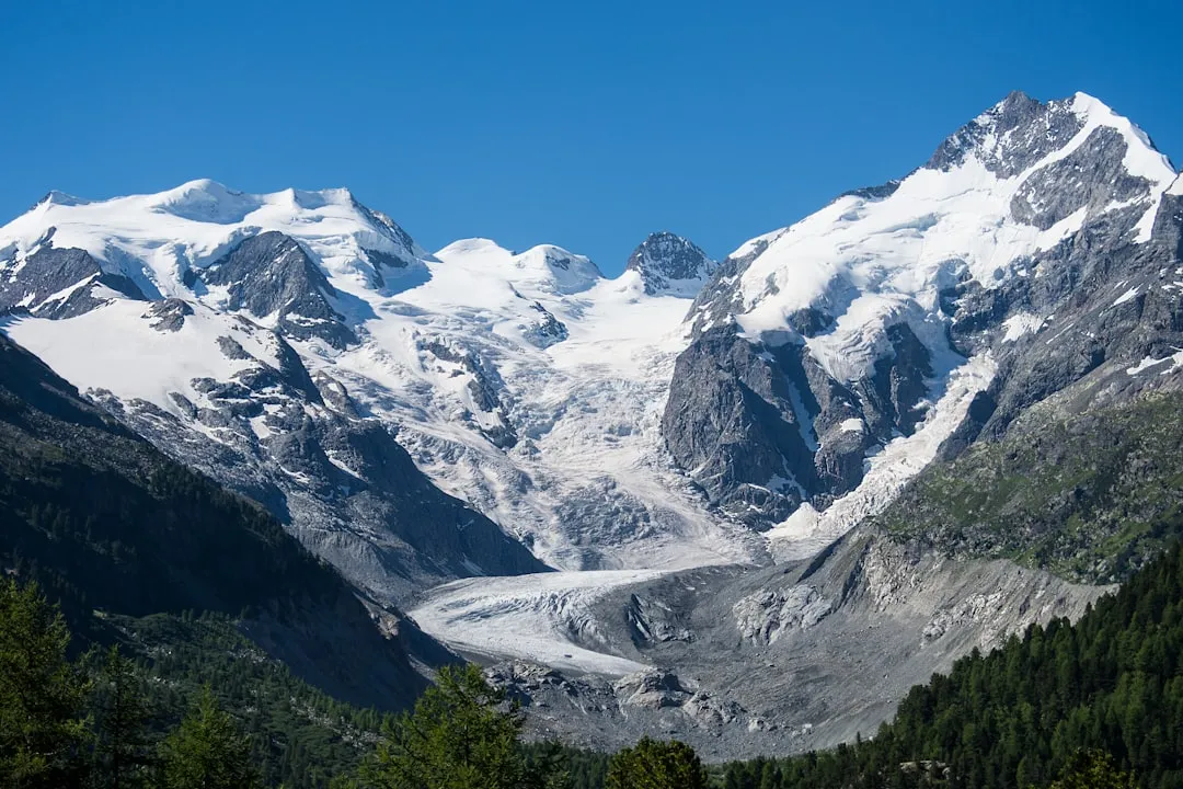
The Piz Bernina Traverse is a quintessential alpine journey, a true test of a mountaineer's mettle and a feast for the eyes. Unlike a typical hiking trail, this route is a high-altitude expedition that navigates through a landscape sculpted by glaciers and punctuated by rugged peaks. The traverse typically begins with a cable car ascent to the Diavolezza, offering immediate, breathtaking vistas of the surrounding Bernina Group, including the imposing Piz Bernina and its satellite peaks. From here, the journey unfolds across a series of glaciers, rocky ridges, and high mountain passes, demanding careful route-finding and proficient use of mountaineering equipment.
The terrain is varied and demanding. Expect to traverse expansive glacial fields, such as the Pers Glacier and the Morteratsch Glacier, where crevasses pose a significant hazard and require expert navigation and roped travel. Rocky sections may involve scrambling or even short climbing pitches, necessitating the use of a helmet and potentially ropes. The weather in the high Alps is notoriously fickle; conditions can change from brilliant sunshine to blizzards within hours, and temperatures can plummet rapidly, especially at higher elevations. This necessitates meticulous preparation and a constant awareness of the prevailing weather patterns.
The reward for this effort is immense. The Piz Bernina Traverse offers an intimate encounter with a raw, powerful alpine environment. The scale of the glaciers, the jaggedness of the peaks, and the sheer remoteness of the area create a profound sense of awe and accomplishment. The route often passes by or offers views of iconic landmarks like the Fuorcla da Boval, the summit of Piz Bernina (though not always summited as part of a standard traverse), and the imposing granite walls of the surrounding mountains. The journey is punctuated by stays in traditional Swiss Alpine Club (SAC) huts, offering a welcome respite and a chance to share experiences with fellow mountaineers.
This traverse is not for the faint of heart or the inexperienced. It demands a solid foundation in glacier travel, crevasse rescue, rock scrambling, and an understanding of alpine weather. However, for those who possess these skills and a spirit of adventure, the Piz Bernina Traverse promises an unforgettable experience in one of the most magnificent mountain ranges in the Alps.
History and Cultural Context
The Bernina Range, and Piz Bernina in particular, has a long and rich history of exploration and mountaineering. The first ascent of Piz Bernina, the highest peak in the Eastern Alps at 4,049 metres, was achieved on 13 September 1850 by Johann Coaz, along with guides Jonas and Lorenz Ragaz. This marked a significant achievement in alpine exploration, opening the door for further ascents and explorations of the surrounding peaks and glaciers.
The development of mountaineering in the Bernina region was closely tied to the establishment of mountain huts by the Swiss Alpine Club (SAC). Founded in 1863, the SAC played a pivotal role in making the high Alps more accessible and safer for climbers. The construction of huts like the Rifugio Marinelli Bombardieri (though technically in Italy, it serves the Bernina massif) and the Cabana Segantini provided essential shelter and bases for expeditions. The Cabana Diavolezza, accessible by cable car, became a crucial starting point for many ascents and traverses in the area.
The concept of a "traverse" of the Piz Bernina massif evolved as mountaineers sought to link various peaks and passes, creating more comprehensive and challenging expeditions. These routes were often pioneered by experienced guides and climbers who pushed the boundaries of what was considered possible. The routes were not formally "built" like hiking trails but rather emerged from the collective knowledge and experience of generations of mountaineers navigating the complex glacial and rocky terrain.
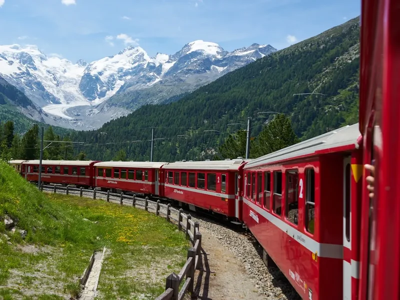
The region's history is also intertwined with the development of tourism in the Engadin valley. The construction of railways, such as the Bernina Railway, and later the cable car to Diavolezza, made the area more accessible, attracting both intrepid mountaineers and sightseers. The Piz Bernina Traverse, while always a demanding objective, became a celebrated route for those seeking the ultimate alpine challenge in this iconic mountain landscape.
Seasonal Highlights and Weather Reality
The Piz Bernina Traverse is a high-altitude mountaineering objective, and its feasibility is heavily dictated by seasonal conditions and weather. The primary season for attempting this traverse is during the summer months, typically from July to September.
Summer (July to September): This is the most favourable period for the traverse. The snow cover on glaciers generally recedes, exposing more rock and making glacier travel more predictable. The days are longer, providing ample daylight for the demanding ascents and descents. Temperatures are generally milder, though still cold at higher elevations, and the risk of significant snow accumulation is lower. However, summer in the Alps is also prone to afternoon thunderstorms, which can develop rapidly and pose a serious hazard, especially on exposed ridges and glaciers. It is crucial to start early in the day to avoid these storms.
Spring (May to June): This period is generally too early for a safe traverse. Glaciers are still heavily snow-covered, and avalanche risk can be high. Many of the high passes and routes will be impassable or require advanced winter mountaineering skills and equipment. The huts may also not yet be fully operational.
Autumn (October onwards): As autumn progresses, temperatures drop significantly, and snowfall becomes more frequent. The days shorten, reducing the available daylight for climbing. Glaciers can become more hazardous with increased ice exposure and potentially unstable snow bridges. The huts typically close for the season by mid-October. Attempting the traverse late in the season requires excellent winter mountaineering skills and a high tolerance for cold and unpredictable weather.
Weather Reality: Regardless of the season, the weather in the Bernina Range is highly unpredictable. Even during the summer, conditions can change dramatically. Expect strong winds, sudden temperature drops, fog, and precipitation (rain or snow). Hypothermia is a constant risk at these altitudes. It is imperative to consult detailed mountain forecasts immediately before and during the trip and to be prepared to alter or abandon plans if conditions are unfavourable.
Recommended Itinerary
2-3 Day Piz Bernina Traverse Itinerary (Example)
Day 1: Ascent to Cabana Diavolezza and Glacier Approach
- Morning: Travel to Bernina Diavolezza cable car station.
- Ascend via cable car to the Diavolezza mountain station (approx. 3,000 m).
- Brief acclimatisation and gear check at the station.
- Begin the traverse by descending towards the Pers Glacier.
- Roped glacier travel across the Pers Glacier, navigating crevasses.
- The route may involve traversing towards the Fuorcla da Boval or a similar high point.
- Ascend to the Cabana Segantini or another suitable high-altitude hut for the night.
- Distance: Variable, approximately 8-10 km (highly dependent on exact route and conditions)
- Elevation Gain: Variable, significant ascent to hut
- Time: 5-7 hours
- Key Waypoints: Diavolezza station, Pers Glacier, Fuorcla da Boval (potential), Cabana Segantini.
Day 2: High Alpine Traverse and Glacier Travel
- Early morning start to maximise daylight and avoid afternoon storms.
- Continue the traverse across glacial terrain, potentially linking to the Morteratsch Glacier.
- This day often involves navigating complex glacial features and potentially rocky sections.
- The exact route will depend on conditions and the chosen objective (e.g., traversing towards Piz Bernina's base, or a different high pass).
- Ascend to a high mountain hut such as the Cabana Morteratsch or a similar SAC hut.
- Distance: Variable, approximately 8-12 km
- Elevation Gain: Significant, with ascents and descents
- Time: 6-8 hours
- Key Waypoints: Pers Glacier, Morteratsch Glacier, various high passes and ridges.
Day 3: Descent and Return (Optional Extension)
- Depending on the chosen route and hut location, this day involves either a descent back towards the valley or a continuation of the traverse.
- If descending, the route will lead back towards the Morteratsch glacier and potentially the Morteratsch railway station.
- Alternatively, if the traverse continues, it might involve reaching another high point or linking to a different descent route.
- The final descent typically involves navigating glacial moraines and then a trail back to a transport link.
- Distance: Variable, approximately 5-10 km
- Elevation Gain: Primarily descent
- Time: 4-6 hours
- Key Waypoints: Morteratsch Glacier, Morteratsch railway station, or other valley access points.
Important Notes:
- This is a sample itinerary; actual routes and timings will vary significantly based on conditions, group ability, and specific objectives.
- All hut bookings must be made in advance.
- This route requires experienced mountaineers with appropriate technical skills and equipment.
- Weather is a critical factor; be prepared to change plans or turn back.
- Carry sufficient food, water, and emergency supplies.
Planning and Bookings
Book Your Trip
Everything you need to plan your journey
Accommodation
Find places to stay near Samedan
Flights
Search flights to Samedan
Essential Preparation
The Piz Bernina Traverse is a serious mountaineering undertaking that demands meticulous planning and preparation. It is not a casual hike and should only be attempted by individuals or groups with proven experience in high-alpine environments. This includes proficiency in glacier travel, crevasse rescue, navigation with map and compass (and GPS), rock scrambling, and an understanding of alpine weather patterns. Fitness is paramount; participants must be able to sustain strenuous effort at high altitudes for extended periods.
Base Town: Samedan is the closest significant town and serves as a convenient base for accessing the Bernina Pass region. It offers accommodation, restaurants, and essential services. St. Moritz is a larger, more upscale resort town nearby with more extensive amenities. Both are well-connected by public transport.
Logistics: Access to the trailhead is typically via the Bernina Pass road or public transport. The Bernina Express train line and local buses connect St. Moritz and Samedan to the Bernina Diavolezza cable car station. Driving is also an option, with parking available at the cable car station. It is advisable to check road conditions, especially outside the main summer season.
Booking Coordination: Hut bookings are essential and should be made well in advance, especially during the peak summer season. The Swiss Alpine Club (SAC) operates most of the relevant huts, and their booking system should be consulted. It is also wise to coordinate with local guides if you are not fully confident in your own technical abilities or knowledge of the route.
Trail Accommodation
Accommodation on the Piz Bernina Traverse is provided by mountain huts (Hütten or Cabanas) operated by the Swiss Alpine Club (SAC) or other organisations. These huts offer basic but essential shelter for mountaineers.
Hut Facilities:
- Dormitory-style sleeping quarters with mattresses and blankets (sleeping bags are mandatory).
- Communal dining areas.
- Basic cooking facilities (often stoves, but bring your own pots and utensils).
- Access to water (often from streams or meltwater; treatment is recommended).
- Toilets (may be basic pit toilets or more modern facilities).
- Some huts may have limited charging facilities for electronic devices, but this is not guaranteed.
What's NOT Provided:
- Food: Huts typically offer meals (breakfast, dinner) for purchase, but it is essential to confirm this when booking. If meals are not provided or you prefer to self-cater, you must bring all your own food.
- Sleeping bags: You must bring your own sleeping bag.
- Cooking equipment: Pots, pans, cutlery, and plates are usually not provided for self-catering.
- Personal toiletries and hygiene items.
- Electricity for charging devices is often limited or non-existent.
Booking Requirements:
- Reservations are mandatory for most SAC huts, especially during the peak season (July-September).
- Bookings can usually be made online through the SAC website or the individual hut's website.
- Membership in the SAC or a reciprocal alpine club often provides discounted rates.
- Check the specific opening and closing dates for each hut, as they can vary.
Seasonal Availability: Huts are generally open from late June/early July to mid-October, depending on snow conditions and demand. Outside these dates, they may be unstaffed or closed.
Costs: Hut fees vary but typically range from CHF 30-70 per night for non-members, with discounts for SAC members. Meals are an additional cost.
Required Gear
- Mountaineering Boots: Sturdy, waterproof, insulated mountaineering boots with a stiff sole suitable for crampons.
- Crampons: Steel crampons compatible with your boots, suitable for glacier travel and potentially icy slopes.
- Ice Axe: A technical ice axe suitable for glacier travel and self-arrest.
- Helmet: Essential for protection against rockfall and during glacier travel.
- Harness: A climbing harness for roped travel.
- Rope: A dynamic climbing rope (typically 50-60 metres) for glacier travel and potential belaying.
- Belay Device and Karabiners: For rope management and safety.
- Navigation Tools: Map of the area, compass, and a GPS device or smartphone with offline maps.
- Head Torch: With spare batteries, for early starts and hut use.
- First Aid Kit: Comprehensive kit including blister treatment, pain relief, bandages, and any personal medications.
- Sun Protection: High SPF sunscreen, lip balm with SPF, sunglasses (glacier glasses recommended), and a wide-brimmed hat or cap.
- Waterproof Outerwear: Waterproof and breathable jacket and trousers (e.g., Gore-Tex) with taped seams.
- Warm Layers: Multiple insulating layers (fleece, down jacket), thermal base layers (merino wool or synthetic).
- Gloves: Warm, waterproof gloves and liner gloves.
- Hat: Warm beanie or balaclava.
- Backpack: A robust mountaineering backpack (40-60 litres) with a rain cover.
What to Bring
- Food: High-energy, lightweight food for lunches and snacks for each day. If not purchasing meals at huts, bring all food for the duration.
- Water Bottles/Hydration Reservoir: At least 2 litres capacity.
- Water Treatment: Water filter or purification tablets, as stream water may not always be safe to drink directly.
- Sleeping Bag: A warm sleeping bag rated for sub-zero temperatures (e.g., comfort rating of -5°C to -10°C).
- Toiletries: Toothbrush, toothpaste, biodegradable soap, small towel, toilet paper.
- Personal Items: Camera, power bank for electronics, book or journal.
- Duct Tape and Repair Kit: For minor gear repairs.
- Emergency Bivvy Bag: Lightweight emergency shelter.
- Trekking Poles: Highly recommended for stability on descents and ascents, and for glacier travel.
- Cash: For hut fees and meals, as card payment facilities may be limited or unavailable.
Permits

For the Piz Bernina Traverse, formal permits in the same way as national park hiking trails are generally not required. However, access to the region and the use of mountain huts are governed by specific regulations and booking procedures.
Mountain Hut Bookings: This is the most critical aspect of "permitting" for this route. All Swiss Alpine Club (SAC) huts, and other huts in the region, require advance reservations, especially during the peak summer season (July to September). Failure to book a hut means you will not have accommodation, which is essential for a multi-day traverse.
Booking Process:
- SAC Huts: Bookings are typically made online through the SAC website (sac-cas.ch) or the individual hut's website.
- Membership: Membership in the SAC or a reciprocal alpine club (e.g., Alpine Club in the UK, American Alpine Club) often grants access to discounted rates and sometimes priority booking.
- Availability: Huts can fill up quickly, particularly on weekends and during popular periods. It is advisable to book several months in advance.
- Confirmation: Ensure you receive a booking confirmation and understand the cancellation policy.
Cable Car and Public Transport: While not a permit, you will need to purchase tickets for the Bernina Diavolezza cable car and any public transport (trains, buses) used to reach the trailhead. These are standard commercial services.
National Park Regulations: The Bernina region is within a protected landscape, and while specific permits for traversing are not usually issued, general rules regarding camping, fires, and waste disposal must be adhered to. Always respect the natural environment.
Guides: If you hire a certified mountain guide, they will typically handle the hut bookings as part of their service. However, you will still need to pay for the huts and any meals directly or as part of the guide's package.
No Registration at Trailhead: Unlike some remote wilderness areas, there is no formal registration system at the trailhead for the Piz Bernina Traverse. Your booking of huts and your personal preparedness are your primary means of ensuring a safe and legal expedition.
Other Activities in the Area
The Engadin Valley and the Bernina region offer a wealth of activities beyond the Piz Bernina Traverse, catering to various interests and fitness levels:
- Bernina Express: Experience the spectacular UNESCO World Heritage Bernina Railway line, a marvel of engineering that winds through dramatic mountain scenery, crossing viaducts and tunnels. It's a scenic journey in itself.
- Hiking and Trekking: Numerous well-marked hiking trails exist throughout the Engadin, ranging from gentle valley walks to more challenging mountain routes. Popular areas include the trails around St. Moritz, Pontresina, and the various side valleys.
- Via Ferrata: The region boasts several via ferratas (iron paths) that offer a thrilling way to experience cliff faces and high-altitude viewpoints. The Via Ferrata Piz da las Trais Linguas is a notable example.
- Mountain Biking: The Engadin is a paradise for mountain bikers, with dedicated trails and routes for all skill levels, from leisurely rides to technical downhill courses.
- Lake Exploration: The Engadin is dotted with beautiful lakes, such as Lake St. Moritz, Lake Silvaplana, and Lake Sils. These offer opportunities for swimming, sailing, windsurfing, and paddleboarding in the summer.
- Skiing and Snowboarding: In winter, the Bernina region is a world-class destination for winter sports, with extensive ski resorts like Corviglia, Diavolezza-Lagalp, and Zuoz.
- Cultural Attractions: Explore charming towns like St. Moritz and Samedan, visit local museums, and enjoy the unique Engadin culture and cuisine.
- Spa and Wellness: St. Moritz and other towns offer excellent spa facilities for relaxation and rejuvenation after a day of outdoor activity.
Safety and Conditions
Pre-Departure Checks:
- Weather Forecast: Always check the detailed mountain weather forecast (e.g., MeteoSwiss, MeteoBlue) for the Bernina region immediately before and during your trip. Pay close attention to wind speed, temperature, precipitation, and thunderstorm probability.
- Route Conditions: Consult the Swiss Alpine Club (SAC) or local mountain guide offices for the latest information on snow conditions, crevasse hazards, and any route closures or advisories. Websites like bergportal.ch or local tourism sites can be helpful.
- Avalanche Risk: Outside of the main summer season, or if significant new snow has fallen, assess the avalanche risk using the official Swiss avalanche bulletin (slf.ch).
- Gear Check: Ensure all your mountaineering equipment is in good working order and that you have the correct items for the expected conditions.
Alpine Hazards:
- Crevasses: Glaciers like the Pers and Morteratsch are riddled with crevasses, some of which can be hidden by snow bridges. Roped travel with proper crevasse rescue techniques is non-negotiable.
- Weather Changes: The high Alps are notorious for rapid weather shifts. Afternoon thunderstorms are common in summer and can bring lightning, heavy rain, and hail, making exposed positions extremely dangerous.
- Hypothermia: Even in summer, temperatures at altitude can be very cold, especially with wind chill. Proper layering and protection are essential.
- Altitude Sickness: While the traverse may not reach extreme altitudes, acclimatisation is important. Be aware of the symptoms of altitude sickness (headache, nausea, dizziness) and descend if symptoms worsen.
- Rockfall: Especially on approaches and descents, and in areas with loose scree, rockfall can be a hazard. Wearing a helmet is crucial.
- Navigation: In poor visibility (fog, snow), navigation can become extremely difficult. Rely on a combination of map, compass, and GPS, and be prepared to wait out bad weather if necessary.
Emergency Procedures:
- Emergency Numbers: In Switzerland, the general emergency number is 144 for medical emergencies and 112 for general emergencies. For mountain rescue, contact REGA (Swiss Air Rescue) at +41 33 814 14 14 or via their app.
- Communication: Mobile phone reception can be unreliable in the mountains. Consider carrying a personal locator beacon (PLB) or satellite messenger for emergencies.
- Group Safety: Always stay together as a group, communicate clearly, and make decisions collectively. Never leave a member of your party behind.
Travel Insurance: Ensure your travel insurance covers high-altitude mountaineering and potential rescue operations. This is a critical safety net.
Side Trips and Points of Interest
Piz Bernina Summit (4,049 m): While not always included in a standard traverse, the summit of Piz Bernina is the highest peak in the Eastern Alps and a significant mountaineering objective. Ascending it typically requires an additional day and advanced technical skills, often involving a bivouac or a very early start from a high hut. The views from the summit are unparalleled.
Fuorcla da Boval: This high pass is often a key point on traverse routes, offering spectacular panoramic views of the Bernina massif, including Piz Bernina, Piz Roseg, and the surrounding glaciers. It serves as a gateway between different glacial systems.
Cabana Segantini: A picturesque SAC hut situated in a stunning location, offering incredible views of the Bernina Group. It's a popular stop for acclimatisation and a base for various climbs and traverses in the area.
Morteratsch Glacier: One of the largest glaciers in the Bernina Range, the Morteratsch Glacier is a significant feature of many traverse routes. Observing its scale and the effects of glacial retreat can be a poignant experience.
Piz Roseg (3,935 m): A striking, pyramid-shaped peak often visible from traverse routes. While a challenging climb in itself, its proximity makes it a tempting objective for experienced mountaineers.
The Bernina Railway: Although not a side trip in the traditional sense, the iconic Bernina Railway line runs through the region and offers breathtaking views of the same landscapes you might be traversing. It can be used for access or egress and provides a different perspective on the mountains.
Leave No Trace
The Piz Bernina Traverse takes you through a pristine and fragile alpine environment. Adhering to Leave No Trace principles is paramount to preserving this wilderness for future generations and ensuring the safety of all who venture here.
Plan Ahead and Prepare: Understand the route, weather, and potential hazards. Be prepared with the right gear and skills. Inform someone of your plans and expected return time.
Travel and Camp on Durable Surfaces: On this traverse, "durable surfaces" primarily refer to established hut areas and the most direct routes across glaciers and scree slopes. Avoid trampling fragile alpine vegetation, which can take decades to recover. Stick to marked paths where they exist and follow your guide's or experienced companion's lead on glacier travel.
Dispose of Waste Properly: Pack out everything you pack in. This includes all food scraps, wrappers, and any other refuse. Human waste should be disposed of in designated toilet facilities at huts. If no facilities are available, dig a cathole at least 60 metres from water sources, trails, and campsites, and bury your waste. Pack out toilet paper.
Leave What You Find: Do not disturb or remove any natural objects, rocks, or plants. Take only photographs and memories.
Minimise Campfire Impacts: Campfires are generally not permitted in high alpine environments due to the risk of environmental damage and fire hazard. Use a portable stove for cooking.
Respect Wildlife: Observe wildlife from a distance and never feed them. Feeding animals can alter their natural behaviour, make them dependent on human food, and pose health risks to both the animals and humans.
Be Considerate of Other Visitors: Share the mountain environment with respect. Keep noise levels down, especially in huts, and yield to others on narrow sections of the route.
The high alpine environment is particularly sensitive. Every action has a magnified impact. By following these principles, you help maintain the wild beauty and ecological integrity of the Bernina Range.