
Pindos Horseshoe Trail - The Limestone Heart of Northern Greece
The Pindos Horseshoe Trail is a premier high-altitude trekking circuit located within the Vikos-Aoos National Park in the Epirus region of northwestern Greece. Spanning approximately 72 kilometres, this challenging multi-day journey traverses the dramatic Tymfi massif, circles the rim of the world-record-holding Vikos Gorge, and visits the legendary alpine "Dragon Lakes." Unlike the more famous Mount Olympus, the Pindos Horseshoe offers a more intimate encounter with the unique "Zagori" culture—a network of 46 stone-built villages connected by ancient mule tracks and arched stone bridges that date back to the Ottoman era. The trail is a masterclass in geological diversity, transitioning from the deepest gorge in the world (relative to its width) to barren, lunar-like limestone plateaus and jagged peaks exceeding 2,400 metres. This is not merely a hike; it is a traverse through a landscape where myth and geology are inextricably linked, providing a profound sense of isolation in one of Europe's last true wildernesses.
- Distance: 72.0 km circuit
- Elevation Gain: 4,000 m total ascent
- Duration: 6–8 days
- Difficulty: Challenging (requires high fitness and mountain experience)
- Best Time: June to September (snow persists on high passes until late May)
- Highest Point: Mount Gamila (2,497 m)
- Base Town: Ioannina (nearest airport)
- Trailhead: Mikro Papingo
Overview
The Pindos Horseshoe Trail is widely regarded as the most spectacular mountain trek in the Balkans. The route is defined by its "horseshoe" shape, which skirts the massive limestone fortress of Mount Tymfi. The journey begins and ends in the Zagori region, a UNESCO World Heritage site famed for its "stone architecture" where every house, roof, and path is crafted from local grey limestone. The trail's primary allure lies in its staggering verticality. One day you are standing on the edge of the Vikos Gorge, looking down nearly 1,000 metres to the turquoise Voidomatis River; the next, you are ascending the "Astraka Towers," massive vertical monoliths that dominate the skyline above the village of Papingo.
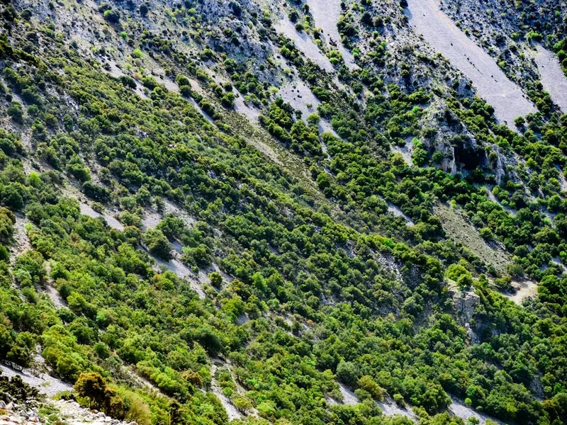
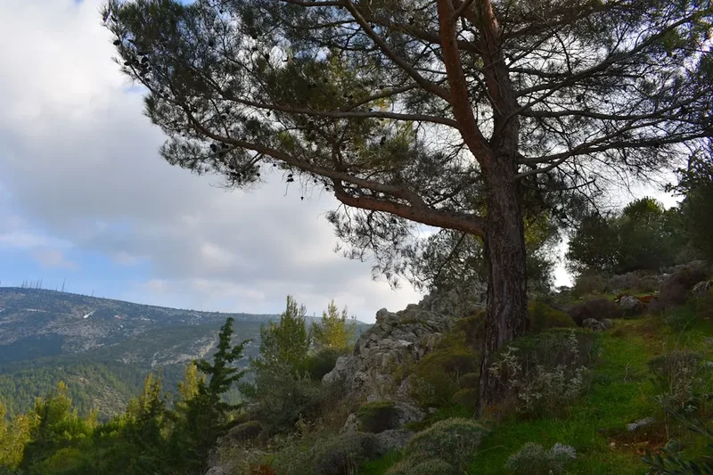
The terrain is predominantly limestone karst, which creates a landscape of dramatic contrasts. Because limestone is porous, surface water is rare on the high plateaus, leading to the formation of deep sinkholes, vertical caves, and the famous "Drakolimni" (Dragon Lakes)—glacial tarns that remain filled year-round and are home to the rare alpine newt. The ascent is relentless, with the trail often climbing 1,000 metres in a single morning, only to descend into a lush valley by afternoon. This constant change in microclimate means walkers move through Mediterranean scrub, dense beech and pine forests, and finally into the alpine zone where only hardy wildflowers and chamois survive.
While the physical demands are high, the rewards are unparalleled. The Pindos Horseshoe avoids the commercialisation found in many Alpine routes. Instead of large hotels, walkers stay in mountain refuges or traditional stone guesthouses in villages that feel frozen in time. The hospitality of the Epirus region is legendary, and the local cuisine—rich in mountain herbs, local cheeses, and the famous "Zagoropita" (flaky phyllo pies)—provides the necessary fuel for the arduous climbs. For those seeking a combination of world-class geology, deep historical roots, and a genuine physical test, the Pindos Horseshoe Trail stands as a pinnacle of European trekking.
History and Cultural Context
The history of the Pindos mountains is a tapestry of isolation, resilience, and strategic importance. For centuries, the Zagori region was a semi-autonomous province within the Ottoman Empire. Because of the rugged terrain, the Ottomans found it difficult to govern directly, granting the "Zagorians" special privileges in exchange for taxes. This led to a period of great prosperity in the 17th and 18th centuries, as local merchants travelled as far as Russia and Romania to trade. The wealth they brought back was invested in the magnificent stone mansions (archontika), schools, and the iconic arched stone bridges that walkers still cross today. These bridges, such as the Kokkoros or Plakidas bridges, were engineered without mortar, relying on the perfect placement of stones to withstand the winter torrents.
The mountains also hold a darker, more modern history. During World War II and the subsequent Greek Civil War, the Pindos range was a stronghold for the Greek Resistance. The deep caves and inaccessible plateaus provided cover for partisans fighting against Axis occupation. Many of the trails used by modern hikers were originally carved out by these fighters or by the Sarakatsani—nomadic Greek shepherds who moved their flocks of sheep and goats from the lowland plains to the high mountain pastures every summer. Even today, you may encounter these shepherds and their fierce Greek Shepherd dogs, continuing a transhumance tradition that has remained largely unchanged for millennia.
Culturally, the region is steeped in folklore. The "Dragon Lakes" (Drakolimni) get their name from local legends of two dragons who lived on Mount Tymfi and Mount Smolikas. According to the myth, the dragons were rivals and threw rocks and trees at each other, creating the scattered boulders and the distinct geological features of the landscape. Today, the Vikos-Aoos National Park is a protected area, recognised not only for its natural beauty but as a living museum of human adaptation to a vertical world. The inclusion of the Zagori Cultural Landscape on the UNESCO World Heritage list in 2023 confirms the global significance of this unique intersection between nature and human craftsmanship.
Want more background? Read extended notes on history and cultural context → Learn more
Seasonal Highlights and Weather Reality
The window for completing the full Pindos Horseshoe Trail is relatively narrow due to the high altitude and the heavy snowfall that the Epirus region receives. While Greece is often associated with Mediterranean heat, the Pindos mountains behave like the Alps, with weather systems moving in rapidly from the Ionian Sea.
Summer (June to August): This is the peak trekking season. By mid-June, most of the snow has melted from the high passes, though small patches may remain near the Dragon Lakes. July and August offer the most stable weather, but temperatures in the valleys and the Vikos Gorge can soar above 35°C. On the high plateaus, however, it remains pleasantly cool, though afternoon thunderstorms are common and can be violent. These "Astraka storms" bring heavy rain and lightning, making it essential to reach your destination or a shelter by mid-afternoon.
Autumn (September to October): Many experienced trekkers consider September the best month. The heat of summer has dissipated, the air is exceptionally clear, and the deciduous forests of the lower slopes begin to turn vibrant shades of gold and red. Water sources become scarcer in autumn, as the limestone drains the summer meltwater, so careful planning is required. By mid-October, the first snowfalls usually arrive on the peaks, and the mountain refuges begin to close for the season.
Spring (April to May): While the lower Zagori villages are beautiful in spring with blooming wildflowers, the high-altitude sections of the Horseshoe remain under deep snow. Attempting the full circuit during this time requires winter mountaineering skills, ice axes, and crampons. The risk of avalanches in the steep couloirs of Mount Tymfi is significant during the spring thaw.
Winter (November to March): The Pindos Horseshoe becomes a serious winter mountaineering objective. The refuges are closed (except by special arrangement), and the trail is often buried under several metres of snow. Temperatures can drop to -20°C on the plateaus. This season is only for highly experienced winter climbers and ski tourers.
Recommended Itinerary
7-Day Pindos Horseshoe Circuit
Day 1: Mikro Papingo to Astraka Refuge
- Distance: 6 km
- Elevation gain: 1,000 m
- Time: 3–4 hours
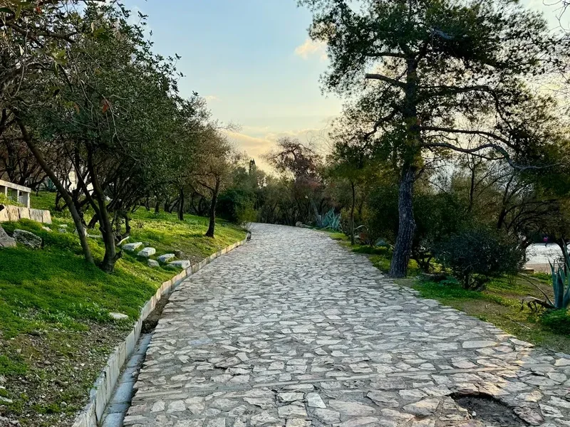
- Start in the stone village of Mikro Papingo (980 m)
- Steady, steep ascent on a well-marked cobblestone path (skala)
- Pass four natural springs (Avragonios, Antalki, Trafo, Krouna)
- Arrive at Astraka Refuge (1,950 m) situated on the saddle between Mt Astraka and Mt Lapatos
- Spectacular evening views of the "Towers of Papingo"
- The short distance belies the effort; the vertical gain is significant and serves as a "leg-breaker" for the start of the trip
Day 2: Astraka Refuge to Drakolimni (Dragon Lake) and Mt Gamila
- Distance: 12 km (return)
- Elevation gain: 800 m
- Time: 6–7 hours
- Descend from the refuge to the Xeroloutsa seasonal lake
- Ascend to the edge of the plateau to reach Drakolimni (2,050 m)
- Search for alpine newts in the crystal-clear water
- Continue to the summit of Mt Gamila (2,497 m), the highest point of the massif
- Return to Astraka Refuge for a second night
- This day explores the high alpine heart of the Horseshoe with 360-degree views into the Aoos Canyon
Day 3: Astraka Refuge to Tsepelovo
- Distance: 15 km
- Elevation gain: 400 m ascent, 1,300 m descent
- Time: 7–8 hours
- Cross the vast, arid "Megala Litharia" (Great Stones) plateau
- Pass the "Hole of the Virgin" (Trypa tis Panagias), a massive vertical shaft
- Descend through the "Stadi" pass into the lush forest above Tsepelovo
- Arrive in Tsepelovo (1,080 m), the highest of the Zagori villages
- Stay in a traditional stone guesthouse and enjoy local Epirus cuisine
Day 4: Tsepelovo to Vradeto and the Beloi Viewpoint
- Distance: 12 km
- Elevation gain: 600 m
- Time: 5–6 hours
- Walk through oak and beech forests to the remote village of Vradeto (1,340 m)
- Continue to the Beloi viewpoint, the most dramatic overlook of the Vikos Gorge
- Peer down 900 m to the gorge floor
- Return to Vradeto for the night
- This section transitions from the high peaks to the rim of the world's deepest canyon
Day 5: Vradeto to Monodendri via the Vradeto Steps
- Distance: 10 km
- Elevation gain: 200 m ascent, 600 m descent
- Time: 4–5 hours
- Descend the famous "Vradeto Steps" (Skala Vradetou), a 1,200-step stone staircase built in the 18th century
- Cross two historic stone bridges at the bottom of the gorge
- Ascend the opposite side to the village of Kapesovo, then transfer or walk to Monodendri (1,060 m)
- Visit the Monastery of Agia Paraskevi, perched on the edge of the abyss
- Monodendri is a hub for the region and offers excellent amenities
Day 6: Monodendri to Vikos Village (The Gorge Traverse)
- Distance: 13 km
- Elevation gain: 300 m ascent, 400 m descent
- Time: 6–7 hours
- Descend into the heart of the Vikos Gorge
- Walk along the riverbed (mostly dry in summer) surrounded by 1,000 m limestone walls
- Pass the springs of the Voidomatis River (the coldest and cleanest river in Europe)
- Steep final ascent to the village of Vikos (770 m)
- The gorge traverse is the signature experience of the trail, offering a unique perspective on the scale of the Pindos
Day 7: Vikos Village to Mikro Papingo
- Distance: 4 km
- Elevation gain: 350 m
- Time: 2–3 hours
- Descend from Vikos to the Voidomatis springs for a final swim (if you can brave the 4°C water)
- Ascend the final "skala" back to Mikro Papingo
- Complete the Horseshoe circuit
- Celebrate with a meal in the village square under the plane trees
Important Notes:
- Water is extremely scarce on the Astraka plateau; carry at least 3 litres
- The Vradeto Steps are slippery when wet; use trekking poles
- The Vikos Gorge section can be extremely hot; start at dawn
- Refuge bookings must be made months in advance for July/August
- Mobile signal is intermittent in the gorge and on the high plateaus
Planning and Bookings
Book Your Trip
Everything you need to plan your journey
Accommodation
Find places to stay near Ioannina
Flights
Search flights to Ioannina
Essential Preparation
The Pindos Horseshoe Trail requires a high level of physical fitness and mountain competence. You will be carrying a multi-day pack over steep, rocky terrain with significant elevation changes. Preparation should focus on cardiovascular endurance and leg strength. If possible, train on uneven surfaces to prepare your ankles for the limestone karst, which can be sharp and unstable.
Logistically, the city of Ioannina is your primary hub. It features an airport with daily flights from Athens, a major bus terminal (KTEL) connecting to the rest of Greece, and numerous outdoor shops where you can buy camping gas (screw-top canisters are widely available). From Ioannina, you must take a local bus or a taxi to Mikro Papingo. Note that buses to the Zagori villages are infrequent (often only twice a week), so many hikers opt for a private transfer or a rental car, which can be left in the public parking area at the entrance of Mikro Papingo.
Trail Accommodation
Accommodation on the Pindos Horseshoe is a mix of high-altitude mountain refuges and village guesthouses. This variety is one of the trail's highlights, allowing you to experience both the ruggedness of the peaks and the comfort of traditional Greek hospitality.
Astraka Refuge: Located at 1,950 m, this is the only high-altitude hut on the route. It is a large, stone-built facility that sleeps 51 people in dormitory-style bunks.
- Facilities: Bunk beds with blankets (liner required), shared bathrooms, cold showers (usually), a restaurant serving hot meals (pasta, soup, omelettes), and a small shop for snacks.
- Booking: Essential. Bookings are made via the official Astraka Refuge website. It fills up quickly on weekends.
- Cost: Approximately €15–€20 per night for a bed.
- Note: There is no electricity for charging phones, and water is strictly rationed.
Village Guesthouses (Tsepelovo, Vradeto, Monodendri, Vikos, Papingo): These are generally small, family-run "Xenonas."
- Facilities: Private rooms with en-suite bathrooms, heating, and often incredible breakfasts included.
- Booking: Can be booked via standard online platforms. In peak season (August), book at least 2 months in advance.
- Cost: €50–€90 per night for a double room.
Camping: Wild camping is technically prohibited within the National Park core (especially in the Vikos Gorge). However, it is generally tolerated near the Astraka Refuge if the hut is full, provided you follow Leave No Trace principles. There are no formal campsites with facilities along the trail.
Required Gear
- Footwear: Sturdy trekking boots with high ankle support and a stiff sole (Vibram or similar). The limestone karst is brutal on soft shoes and can easily cause rolled ankles.
- Clothing: A layered system is vital. Include a moisture-wicking base layer, a fleece or down mid-layer for the refuge (even in summer, it gets cold at 2,000 m), and a high-quality waterproof shell (Gore-Tex).
- Navigation: A physical map (Anavasi 1:25,000 Vikos-Aoos is the gold standard) and a GPS device or smartphone with offline maps (e.g., Gaia GPS or AllTrails). The trail is generally well-marked with red paint, but fog on the plateau can make navigation impossible without tools.
- Backpack: A 40–50 litre pack with a proper suspension system and rain cover.
- Trekking Poles: Highly recommended for the steep descents into the Vikos Gorge and the Vradeto Steps to save your knees.
- Sun Protection: High-SPF sunscreen, a wide-brimmed hat, and UV-rated sunglasses. The reflection off the white limestone is intense.
What to Bring
- Water Treatment: While there are springs on the ascent to Astraka, the plateau is dry. Bring a filter (Sawyer Squeeze or Katadyn BeFree) or purification tablets for water collected from the Dragon Lakes or seasonal ponds.
- Hydration: Capacity to carry at least 3 litres of water.
- Food: While you can eat at the refuge and in villages, bring high-energy snacks (nuts, dried fruit, energy bars) for the long stretches between settlements. Lunch is usually a picnic on the trail.
- Cash: Many guesthouses and the Astraka Refuge do not accept credit cards. Ensure you have enough Euros to cover your stay, meals, and potential emergency transport.
- Personal Items: A lightweight sleeping bag liner (mandatory for the refuge), a quick-dry towel, and a basic first-aid kit (including plenty of blister plasters/Compeed).
- Power Bank: To keep your phone/GPS charged, as outlets are rare in the refuge.
Permits
Currently, no formal permits are required to hike the Pindos Horseshoe Trail or to enter the Vikos-Aoos National Park. Access is free for all visitors. However, this lack of a permit system means there is no official "check-in" for safety, making it even more important to leave your itinerary with your first guesthouse or a friend.
Refuge Reservations: While not a "permit," your reservation at the Astraka Refuge acts as your de facto permission to stay in the high mountains. During the peak months of July and August, the refuge is often fully booked weeks in advance. If you arrive without a reservation, you may be asked to sleep on the floor of the dining room or pitch a tent outside (for a small fee).
National Park Regulations: While you don't need a permit, you must adhere to strict National Park rules:
- No fires are allowed anywhere in the park.
- No camping in the core zone of the Vikos Gorge.
- No hunting or removal of plants/fossils.
- Dogs must be kept on a lead (though be aware of large, free-roaming shepherd dogs which may be aggressive toward pets).
Group Sizes: If you are leading a commercial group of more than 10 people, you should contact the Management Body of the Northern Pindos National Park in Aspraggeli to inform them of your dates and route, though this is rarely enforced for private groups.
Other Activities in the Area
The Epirus region is an outdoor enthusiast's paradise. If you have extra days, consider these activities:
- Rafting the Voidomatis River: Starting near the Aristi bridge, this is a gentle but stunning raft trip through the lower section of the Vikos-Aoos National Park. The water is incredibly clear and drinkable.
- Canyoning in the Papingo Rock Pools: Located between Megalo and Mikro Papingo, these natural limestone pools (Rogovo) are perfect for a refreshing dip or a more technical canyoning descent in the upper reaches.
- Exploring Ioannina: The regional capital is built on the shores of Lake Pamvotis. Visit the Byzantine castle, the silver-smithing museum, and take a boat to the island in the middle of the lake (one of the few inhabited lake islands in Europe).
- Meteora: While a 3-hour drive away, the "monasteries in the sky" at Meteora are a perfect post-hike cultural extension. These UNESCO-listed monasteries are perched on massive conglomerate rock pillars.
- Via Ferrata in Konitsa: For those with a head for heights, the via ferrata along the Aoos River near Konitsa offers a thrilling perspective on the northern edge of the Tymfi massif.
Safety and Conditions
Mountain Weather: The Pindos range creates its own weather. Even on a forecast "sunny day," clouds can build rapidly over the Astraka plateau. Lightning is a significant risk on the high, exposed ridges. If you see dark clouds forming and hear thunder, descend from the ridges immediately. Hypothermia is a risk even in summer if you are caught in a cold rainstorm without proper gear.
Terrain Hazards: The limestone karst is exceptionally sharp. A fall can result in deep lacerations. Furthermore, the area is famous for its "vertical caves." Some shafts, like the Provatina (one of the deepest in the world), are located near the trail. Stay on the marked path, especially in low visibility, to avoid falling into a sinkhole.
Wildlife: The Pindos mountains are home to the European brown bear, the grey wolf, and the Balkan chamois. While bears and wolves are shy and rarely seen, you should store your food securely. The most common animal "danger" comes from the Greek Shepherd dogs (Hellenikos Poimenikos) guarding flocks. If you encounter a flock, do not walk through the middle of it. Give the sheep a wide berth. If a dog approaches barking, stand your ground, do not run, and wait for the shepherd to call it off. Using trekking poles as a barrier (but not hitting the dog) can help.
Water Scarcity: Dehydration is the most common medical issue on this trail. The limestone does not hold surface water. Between the springs on the way to Astraka and the village of Tsepelovo, there is almost no reliable running water. You must carry enough for the entire day's traverse.
Emergency Services: The emergency number in Greece is 112. However, mountain rescue is not as highly organised as in the Alps. In the event of an accident, rescue may be carried out by the local fire service (EMAK) and can take many hours. A Personal Locator Beacon (PLB) is highly recommended for solo hikers.
Side Trips and Points of Interest
Drakolimni of Tymfi: This "Dragon Lake" is the most iconic spot in the Pindos. Sitting at 2,050 m on the edge of a cliff that drops 1,000 m into the Aoos Valley, the lake is a perfect circle of blue. It is inhabited by Ichthyosaura alpestris (alpine newts), which look like miniature dragons, lending weight to the local legends. The best time to visit is at sunrise when the water is still and reflects the surrounding peaks.
The Vradeto Steps (Skala Vradetou): Before a road was built in the 1970s, this stone staircase was the only way for the people of Vradeto to reach the rest of the world. It is a masterpiece of dry-stone engineering, consisting of three lanes (two for people, one for mules) and over 1,200 steps. The way it zig-zags down a near-vertical cliff face is a testament to the ingenuity of the Zagorian stonemasons.
The Stone Forest (Petrino Dasos): Located on the road between Monodendri and Oxya, this is a geological phenomenon where horizontal layers of limestone have weathered into vertical "trees" of stone. It looks like a petrified forest and provides a surreal backdrop for a short walk.
The Voidomatis Springs: At the bottom of the Vikos Gorge, near the end of the traverse, the Voidomatis River bursts out of the rocks in a series of powerful springs. The water is a constant 4°C year-round and is so pure it can be drunk directly from the source. The surrounding plane trees and the turquoise pools create a hidden oasis that feels completely disconnected from the arid peaks above.
Leave No Trace
The Vikos-Aoos National Park is a fragile ecosystem. The high-altitude flora has a very short growing season and can be easily destroyed by trampling. As a UNESCO World Heritage site, it is our collective responsibility to preserve its integrity.
Specific LNT Guidelines for Pindos:
- Waste: Pack out everything. This includes organic waste like banana peels or orange skins, which decompose very slowly in the thin alpine air and can be harmful to local wildlife.
- Human Waste: Use the toilets at the refuge and in the villages. If you must go on the trail, dig a "cathole" at least 15–20 cm deep and at least 60 m from any water source (including the Dragon Lakes). Pack out your toilet paper in a sealed bag.
- Water: Do not use soap or sunscreen in the Dragon Lakes or the Voidomatis River. The alpine newts are extremely sensitive to chemical changes in their environment.
- Stone Structures: Do not move stones to build cairns or "shelters." The stones provide habitat for insects and reptiles, and moving them can accelerate erosion on the steep slopes.
- Noise: Respect the silence of the mountains. Loud music or shouting disturbs both the wildlife and the experience of other hikers.