Pindari Glacier Trek - Uttarakhand's Hidden Gem
The Pindari Glacier Trek is a captivating journey into the heart of the Kumaon Himalayas in Uttarakhand, India. This moderate-difficulty trek offers a spectacular immersion into pristine alpine landscapes, traversing through rhododendron forests, charming villages, and alongside the roaring Pindari River. It culminates at the snout of the Pindari Glacier, a majestic icefall that feeds the Pindari River, offering breathtaking views of the surrounding snow-capped peaks. The trek is renowned for its accessibility, relatively gentle gradients for much of its length, and the opportunity to experience local Garhwali culture.
- Distance: 90.0 km (round trip)
- Duration: 9-10 days
- Season: April-June and September-November
- Difficulty: Moderate
- Highest point: Pindari Glacier snout (approx. 3,600 m)
- Base Camp: Loharkhet
- Nearest Airport: Pantnagar (PGH)
- Nearest Major Town: Kathgodam
Overview
The Pindari Glacier Trek is a classic Himalayan expedition that provides an accessible yet profoundly rewarding experience of the Indian Himalayas. Unlike some of the more challenging high-altitude treks, the Pindari Glacier route strikes a balance between stunning natural beauty and manageable physical exertion, making it ideal for trekkers seeking a significant mountain adventure without extreme technical demands. The trek begins in the verdant foothills and gradually ascends through diverse ecological zones, from dense forests of oak and rhododendron to alpine meadows and finally to the stark, majestic beauty of the glacier's terminal moraine.
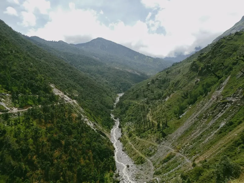
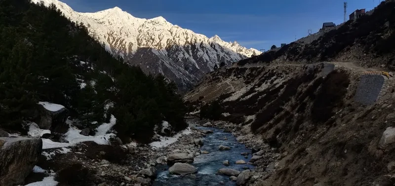
The journey is punctuated by encounters with remote villages like Loharkhet, Dhakuri, and Khati, offering glimpses into the traditional Garhwali way of life. These settlements, perched precariously on hillsides, provide essential resting points and a chance to interact with local communities. The Pindari River, a constant companion for much of the trek, carves its way through deep gorges, its thunderous roar a testament to the raw power of the mountains. As you ascend, the landscape transforms, with wider valleys opening up and the imposing peaks of the Nanda Devi range, including Nanda Devi East and Nanda Kot, beginning to dominate the horizon.
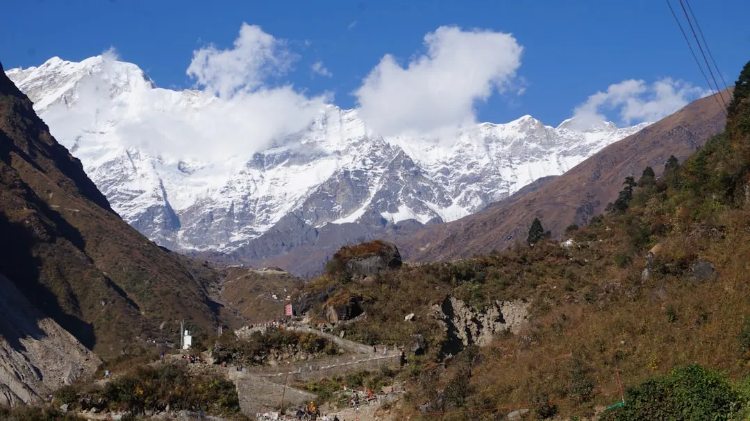
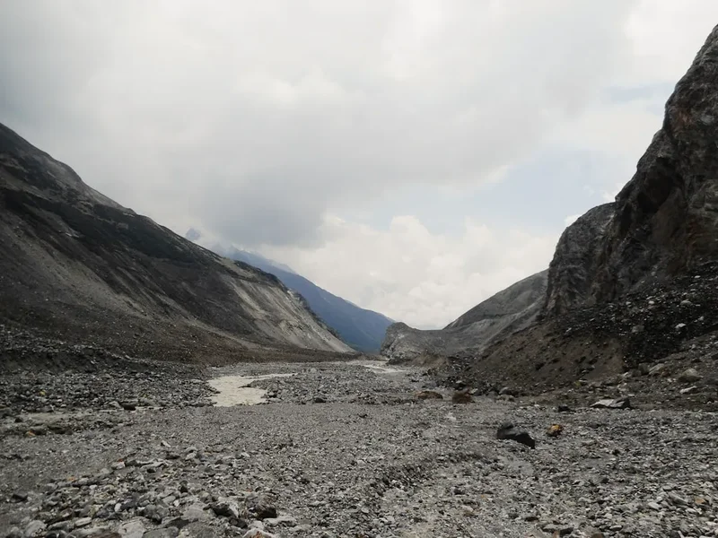
The final approach to the Pindari Glacier snout is a dramatic culmination. The glacier itself, though receding, remains an awe-inspiring sight, a vast expanse of ice and rock that serves as the source of the Pindari River. The panoramic views from the glacier's end, encompassing towering peaks and the immense glacial landscape, are a fitting reward for the days of trekking. The trek's moderate difficulty, combined with its cultural richness and spectacular scenery, makes it a highly sought-after destination for both Indian and international trekkers.
History and Cultural Context
The Pindari Glacier and its surrounding valleys have been known to local communities for centuries. The region, part of the larger Kumaon Himalayas, has a rich history of spiritual significance and traditional trade routes. The Pindari River, originating from the glacier, is considered sacred by Hindus, and the area has long been a destination for pilgrims and ascetics seeking spiritual solace amidst the grandeur of the mountains.
The formal exploration and charting of the Pindari Glacier as a trekking route gained momentum in the early 20th century, coinciding with the broader interest in Himalayan exploration by British surveyors and adventurers. Mountaineers and trekkers were drawn to the region's challenging terrain and the allure of its pristine glacial landscapes. The establishment of basic rest houses and trails by local authorities and trekking organisations facilitated access, transforming it from a route known only to locals into a recognised trekking destination.
The villages along the route, such as Khati, have historically served as important stopovers for traders and travellers moving between the lower hills and the higher mountain passes. The Garhwali people, who inhabit these regions, have a deep-rooted connection to the land, their culture and traditions shaped by the harsh yet beautiful mountain environment. Their resilience, hospitality, and unique way of life are an integral part of the Pindari Glacier experience. The trek offers a unique opportunity to witness this traditional mountain culture firsthand, a stark contrast to the modern world, and to appreciate the enduring spirit of the people who call these remote valleys home.
Seasonal Highlights and Weather Reality
The Pindari Glacier Trek is best undertaken during two distinct windows: spring (April to June) and autumn (September to November). Each season offers a unique perspective on the Himalayan landscape.
Spring (April-June): This period marks the end of winter and the beginning of summer in the Himalayas. The snow begins to melt, revealing the trails and bringing the landscape to life. Rhododendron forests burst into vibrant bloom, painting the hillsides in shades of red, pink, and purple, creating a visually stunning spectacle. The weather is generally pleasant, with clear skies and moderate temperatures during the day, though nights can still be cold, especially at higher altitudes. Snowfall is rare, but occasional showers can occur. This season is excellent for photography and enjoying the blooming flora. However, sandflies can start to become a nuisance as temperatures rise.
Autumn (September-November): Following the monsoon season, autumn offers some of the clearest skies and most stable weather conditions for trekking in the Himalayas. The monsoon rains wash away the dust, leaving the air crisp and the views exceptionally sharp. The landscape transitions from the lush greens of summer to golden hues as vegetation dries. Temperatures are cool to cold, with pleasant days and freezing nights at higher elevations. This is considered the prime trekking season for its excellent visibility of the major peaks, including Nanda Devi and Nanda Kot, and its generally dry conditions. Snowfall is unlikely until late November.
Monsoon (July-August): While the lower reaches might still be green, the monsoon season brings heavy rainfall, increased risk of landslides, and leeches. Visibility of the peaks is severely compromised by cloud cover. This period is generally not recommended for the Pindari Glacier Trek due to safety concerns and poor views.
Winter (December-March): The higher reaches of the Pindari Glacier and the trails can be covered in heavy snow, making the trek extremely challenging and requiring advanced winter mountaineering skills and equipment. Temperatures plummet, and conditions are harsh. This season is suitable only for experienced winter trekkers.
Recommended Itinerary
9-Day Pindari Glacier Trek Itinerary
Day 1: Arrival in Kathgodam & Transfer to Loharkhet
- Distance: Approx. 180 km by road
- Time: 6-7 hours drive
- Arrive at Kathgodam railway station.
- Meet your guide and driver.
- Drive to Loharkhet, the starting point of the trek.
- The drive takes you through scenic valleys and small towns.
- Check into a guesthouse or lodge in Loharkhet.
- Briefing about the trek and acclimatisation.
Day 2: Loharkhet to Dhakuri
- Distance: 12 km
- Elevation gain: Approx. 700 m
- Time: 5-6 hours
- Begin the trek from Loharkhet.
- The trail ascends through oak and rhododendron forests.
- Enjoy panoramic views of the surrounding hills.
- Reach Dhakuri, a picturesque campsite with basic facilities.
- Set up camp or stay in a basic guesthouse.
Day 3: Dhakuri to Khati
- Distance: 14 km
- Elevation gain: Approx. 400 m
- Time: 6-7 hours
- Trek through dense forests and open meadows.
- Cross the Dhakuri Pass (approx. 2,600 m) offering stunning views.
- Descend towards the Pindari River valley.
- Arrive at Khati, the largest village on the trek route.
- Khati offers basic guesthouses and a chance to interact with locals.
Day 4: Khati to Dwali
- Distance: 13 km
- Elevation gain: Approx. 300 m
- Time: 5-6 hours
- Follow the Pindari River downstream initially, then ascend gently.
- The trail becomes more rugged as you move deeper into the valley.
- Pass through small hamlets and agricultural terraces.
- Reach Dwali, a campsite situated near the confluence of two rivers.
- Enjoy the sounds of the rushing water.
Day 5: Dwali to Phurkia
- Distance: 10 km
- Elevation gain: Approx. 600 m
- Time: 4-5 hours
- The trail starts to climb more steeply.
- Enter a more alpine environment with sparse vegetation.
- The air becomes thinner, and the views more expansive.
- Reach Phurkia, a campsite offering close-up views of the surrounding peaks.
- This is a crucial acclimatisation stop.
Day 6: Phurkia to Pindari Glacier Base & Back to Phurkia
- Distance: 10 km (round trip to glacier snout)
- Elevation gain: Approx. 400 m to glacier, then descent
- Time: 6-7 hours
- Today is the highlight of the trek – the journey to the Pindari Glacier snout.
- Trek through a barren, rocky landscape.
- Witness the majestic Pindari Glacier, a vast expanse of ice and moraine.
- Take in the breathtaking views of Nanda Devi East, Nanda Kot, and other peaks.
- Return to Phurkia for the night.
Day 7: Phurkia to Khati
- Distance: 23 km
- Elevation loss: Approx. 900 m
- Time: 7-8 hours
- Begin the descent back towards Khati.
- This is a long day of downhill trekking.
- Enjoy the familiar landscapes from a different perspective.
- Reach Khati by late afternoon.
Day 8: Khati to Dhakuri
- Distance: 14 km
- Elevation gain: Approx. 400 m
- Time: 5-6 hours
- Trek back to Dhakuri.
- This section might feel easier on the descent.
- Relax and enjoy the last night in the mountains.
Day 9: Dhakuri to Loharkhet & Transfer to Kathgodam
- Distance: 12 km trek + 180 km drive
- Time: 4-5 hours trek + 6-7 hours drive
- Trek from Dhakuri back to Loharkhet.
- Board your vehicle for the drive back to Kathgodam.
- Arrive in Kathgodam by evening.
- Overnight stay in Kathgodam or board your onward train.
Note: This itinerary is a guideline and can be adjusted based on weather conditions, group fitness, and available time. An extra day can be added at Khati or Phurkia for rest or exploration.
Planning and Bookings
Book Your Trip
Everything you need to plan your journey
Accommodation
Find places to stay near Kathgodam
Flights
Search flights to Kathgodam
Essential Preparation
The Pindari Glacier Trek requires careful planning, especially regarding logistics and acclimatisation. The closest major town with good transport links is Kathgodam, from where you will arrange your onward journey to the trailhead at Loharkhet. It is highly recommended to book your transport and accommodation in Kathgodam and Loharkhet in advance, particularly during peak trekking seasons. Hiring a reliable local guide and porters is essential for safety, navigation, and carrying gear. Ensure your guide is experienced in the Pindari region and holds necessary certifications. Fitness is paramount; regular cardiovascular exercise, including hiking with a loaded backpack, should be undertaken for at least 2-3 months prior to the trek. Acclimatisation is crucial to prevent altitude sickness; the itinerary is designed with gradual ascents, but listen to your body and communicate any symptoms to your guide. Basic knowledge of first aid and emergency procedures is also advisable.
Trail Accommodation
Accommodation along the Pindari Glacier Trek varies from basic guesthouses in villages to campsites in designated areas. There are no formal lodges or hotels on the trail itself, except for the starting and ending points.
Villages (Loharkhet, Dhakuri, Khati):
- Type: Basic guesthouses or homestays. These are often simple structures with shared rooms and basic amenities.
- Facilities Provided: A roof over your head, a place to sleep (often on the floor with mattresses or simple beds), and sometimes basic meals (dal, rice, roti, vegetables).
- What's NOT Provided: Private bathrooms, hot water, electricity, heating, bedding (sleeping bags are essential), toiletries, or cooking equipment.
- Seasonal Availability: Generally available from April to November. During winter months, many may be closed or inaccessible due to snow.
- Costs: Typically range from ₹500 to ₹1500 per night, depending on the location and facilities.
Campsites (Dhakuri, Dwali, Phurkia):
- Type: Designated camping grounds. You will need to carry your own tents and camping equipment or arrange for them through your trekking agency.
- Facilities Provided: Open spaces for pitching tents. Sometimes basic toilet pits are available. Access to water sources (streams).
- What's NOT Provided: Tents, sleeping bags, cooking gear, food, toilets, or any other amenities.
- Seasonal Availability: Available throughout the trekking season (April-June, September-November).
- Costs: Campsite fees are usually nominal or included in the trekking package.
Note: It is highly recommended to book accommodation in Loharkhet and Kathgodam in advance. For trail accommodation, while some villages have basic guesthouses, camping is often the most reliable option, especially for groups. Ensure your trekking package includes tentage, sleeping bags, and meals if you opt for a full-service trek.
Required Gear
- Sturdy Trekking Boots: Waterproof, ankle-supporting, and well broken-in to prevent blisters.
- Backpack: A 45-65 litre backpack with a rain cover. Ensure it has a good hip belt for weight distribution.
- Sleeping Bag: A 3-season sleeping bag (rated for 0°C to -5°C comfort) is essential, as nights can be cold, especially at higher altitudes.
- Waterproof Jacket and Trousers: Essential for protection against rain and wind. Gore-Tex or similar breathable, waterproof material is recommended.
- Warm Layers: Thermal base layers (merino wool or synthetic), fleece jacket or down jacket for insulation.
- Head Torch: With extra batteries. Essential for navigating in the dark, especially in camps and during early morning starts.
- First-Aid Kit: Including personal medications, blister treatment, pain relievers, antiseptic wipes, bandages, and any specific items recommended by your doctor.
- Sun Protection: High SPF sunscreen, lip balm with SPF, sunglasses (UV protection), and a wide-brimmed hat or cap.
- Navigation Tools: While a guide is essential, carrying a map of the region and a compass is advisable. A GPS device or smartphone with offline maps can be a useful backup.
- Trekking Poles: Highly recommended for reducing strain on knees during ascents and descents.
What to Bring
- Food and Snacks: High-energy snacks like nuts, dried fruits, energy bars, and chocolates. While meals are usually provided by guides in villages or cooked at campsites, carrying personal snacks is important.
- Water Bottles/Hydration Reservoir: At least 2 litres capacity. Water sources are available along the trail, but purification is necessary.
- Water Purification: Water filter, purification tablets, or a UV steriliser.
- Personal Toiletries: Biodegradable soap, toothbrush, toothpaste, hand sanitiser, wet wipes, and toilet paper.
- Quick-Dry Towel: Lightweight and fast-drying.
- Camera: With extra batteries and memory cards to capture the stunning scenery.
- Power Bank: For charging electronic devices, as electricity is scarce on the trail.
- Personal Documents: Identification (ID card/passport), permits (if any), and emergency contact information.
- Cash: Indian Rupees for local purchases, tips, and emergencies. ATMs are not available on the trail.
- Duffel Bag: For porters to carry your main luggage (if using porters).
- Small Daypack: For carrying essentials like water, snacks, camera, and rain gear during daily treks.
Permits
For the Pindari Glacier Trek, specific permits are generally not required for Indian nationals for the standard route up to the glacier snout. However, it is always advisable to check with local authorities or your trekking agency for the most up-to-date information, as regulations can change. Some areas within the broader Nanda Devi Biosphere Reserve might require permits, but the common Pindari Glacier route typically does not necessitate them for basic trekking.
Forest Department Registration: While not a formal permit, registration with the local Forest Department at Loharkhet or the nearest check post might be required. This is often a procedural step to record trekkers entering the protected area and ensure safety. Your guide will usually handle this.
Inner Line Permit (ILP): For foreign nationals, an Inner Line Permit (ILP) might be required to enter certain border regions of Uttarakhand, including areas close to the Tibetan border. While the Pindari Glacier route itself is generally accessible without an ILP, it is crucial for foreign trekkers to verify this requirement with their trekking agency or the Uttarakhand Tourism Development Board well in advance of their trip. Obtaining an ILP can take several days and requires specific documentation.
Nanda Devi Biosphere Reserve: The Pindari Glacier lies within the buffer zone of the Nanda Devi Biosphere Reserve. While the main trek route is usually open, any deviations into restricted zones or areas requiring special access would necessitate additional permits. It is best to confirm with your trekking operator if your itinerary includes any such areas.
Recommendations:
- Consult Your Trekking Agency: The most reliable way to ensure you have all necessary permits and registrations is to book your trek through a reputable local agency. They will be aware of all current requirements and will handle the necessary paperwork.
- Check Official Sources: Before your trip, visit the official website of the Uttarakhand Tourism Development Board or the Forest Department for the latest information on permits and regulations.
- Carry Identification: Always carry a valid photo ID (Aadhaar card for Indians, passport for foreigners) as it may be required for registration or checks along the route.
Other Activities in the Area
While the Pindari Glacier Trek is the primary attraction, the surrounding region offers opportunities for further exploration and cultural immersion:
- Village Exploration: Spend extra time in villages like Khati to understand the local Garhwali culture, architecture, and way of life. Observe traditional farming practices and interact with the friendly locals.
- Short Hikes: From Khati or Dhakuri, short day hikes to nearby viewpoints or smaller hamlets can be arranged with your guide, offering different perspectives of the valleys and peaks.
- Bird Watching: The diverse flora and fauna of the Kumaon Himalayas make it a haven for birdwatchers. Keep an eye out for various species of Himalayan birds.
- Photography: The entire region is a photographer's paradise, from the blooming rhododendrons in spring to the majestic snow-capped peaks and the rustic village life.
- Meditation and Yoga: The serene and spiritual atmosphere of the Himalayas makes it an ideal location for meditation and yoga retreats. Many trekkers find the solitude conducive to introspection.
- Exploring Nearby Valleys: If time and permits allow, consider extending your trip to explore other nearby valleys such as the Sunderdhunga Glacier or the Kafni Glacier, which are often combined with the Pindari trek.
Safety and Conditions
Altitude Sickness (AMS): This is the most significant risk on high-altitude treks. Symptoms include headache, nausea, dizziness, and fatigue. Ascend gradually, stay hydrated, avoid alcohol and smoking, and inform your guide immediately if you experience any symptoms. Diamox can be prescribed by a doctor for prevention.
Weather: Himalayan weather is notoriously unpredictable. Be prepared for sudden changes, including rain, snow, fog, and strong winds, even during the trekking season. Always carry appropriate waterproof and warm clothing.
Trail Conditions: The trails can be steep, rocky, and slippery, especially after rain. Wear sturdy, broken-in trekking boots with good grip. Trekking poles are highly recommended to maintain balance and reduce strain.
River Crossings: While the Pindari River is usually crossed via bridges, during heavy rainfall or snowmelt, water levels can rise rapidly. Always cross rivers with caution and follow your guide's instructions.
Landslides and Rockfalls: These are potential hazards, particularly during the monsoon season or after heavy rain. Stick to marked trails and avoid areas prone to rockfalls.
Wildlife: While encounters with dangerous wildlife are rare, be aware of your surroundings. Respect the natural habitat and do not feed any animals.
Communication: Mobile phone connectivity is extremely limited and unreliable on most parts of the trek. Consider carrying a satellite phone or a Personal Locator Beacon (PLB) for emergencies, especially if trekking independently or in small groups.
Guides and Porters: Hiring experienced local guides and porters is crucial for safety. They are familiar with the terrain, weather patterns, and local conditions. Ensure they are properly equipped and insured.
Emergency Evacuation: Have a plan for emergency evacuation. This may involve hiring a helicopter or arranging for transport back to a medical facility. Travel insurance that covers high-altitude trekking and emergency evacuation is strongly recommended.
Side Trips and Points of Interest
Pindari Glacier Snout: The ultimate destination of the trek. Witnessing the vast expanse of ice and moraine, the source of the Pindari River, is a truly awe-inspiring experience. The sheer scale of the glacier and the surrounding peaks like Nanda Devi East and Nanda Kot is humbling.
Khati Village: The largest and one of the most picturesque villages on the route. Khati offers a glimpse into traditional Garhwali life, with its stone houses, terraced fields, and friendly inhabitants. It's a great place to rest and soak in the local culture.
Dhakuri Pass: A significant landmark on the trek, offering panoramic views of the surrounding valleys and distant snow-capped peaks. The pass is often adorned with prayer flags, adding to its spiritual ambiance.
Rhododendron Forests: Especially vibrant during the spring season (April-May), these forests are a riot of colour. Walking through them is a magical experience, with the air filled with the sweet scent of blossoms.
Pindari River: The constant companion of the trekker, the Pindari River's powerful flow and its journey through dramatic gorges are a highlight. Its roar is a soundtrack to the trek.
Views of Nanda Devi and Nanda Kot: As you ascend, the majestic peaks of the Nanda Devi range, including Nanda Devi East and Nanda Kot, become increasingly visible. These iconic mountains provide a breathtaking backdrop to the entire trek.
Leave No Trace
The Pindari Glacier region is a pristine natural environment, and it is our collective responsibility to preserve its beauty and ecological integrity for future generations. Adhering to Leave No Trace principles is paramount for all trekkers.
- Plan Ahead and Prepare: Research the trail, understand the conditions, and pack appropriately. This includes carrying out all waste.
- Travel and Camp on Durable Surfaces: Stick to the established trails to avoid damaging fragile vegetation. Camp in designated areas or on bare ground where available. Avoid camping near water sources.
- Dispose of Waste Properly: Pack it in, pack it out. This includes all food scraps, wrappers, and any other refuse. Use designated toilets where available, and if not, dig catholes at least 60 metres away from water, trails, and campsites. Pack out all toilet paper.
- Leave What You Find: Do not take any natural objects (rocks, plants, flowers) or cultural artifacts. Leave the environment as you found it.
- Minimize Campfire Impacts: Campfires are generally discouraged or prohibited in high-altitude areas due to the fragile ecosystem and risk of wildfires. Use a portable stove for cooking.
- Respect Wildlife: Observe wildlife from a distance. Never feed animals, as it disrupts their natural behaviour and diet, and can make them dependent on humans or aggressive.
- Be Considerate of Other Visitors: Keep noise levels down, yield to other trekkers, and maintain a respectful attitude towards local communities and their customs.
By following these principles, you help ensure that the Pindari Glacier Trek remains a wild and beautiful place for everyone to enjoy.