Pico Ruivo via Pico do Arieiro - Madeira's Stairway to Heaven
The traverse between Pico do Arieiro and Pico Ruivo, officially designated as the PR1 Vereda do Arieiro, is arguably the most spectacular mountain trek in the North Atlantic. Connecting the third-highest peak (Pico do Arieiro, 1,818 metres) to the highest point on the island (Pico Ruivo, 1,862 metres), this 11-kilometre return journey is a masterclass in volcanic geology and trail engineering. Often referred to as the "Stairway to Heaven," the path clings to the jagged spine of Madeira’s Central Mountain Massif, offering hikers a rare opportunity to walk above a sea of clouds while navigating narrow ridgelines, hand-carved tunnels, and vertical stone staircases. This is not merely a walk; it is a high-altitude odyssey through a landscape that feels more like the Andes or the Himalayas than a Portuguese island. The trail demands physical stamina and a steady head for heights, rewarding those who undertake it with 360-degree panoramas of the island’s emerald valleys and the vast, surrounding Atlantic Ocean.
- Distance: 11.0 km (return)
- Duration: 3.5–5 hours
- Elevation Gain: Approximately 1,000 m (cumulative)
- Difficulty: Challenging (steep ascents, narrow ridges, and tunnels)
- Highest Point: Pico Ruivo (1,862 m)
- Trailhead: Pico do Arieiro car park
- Type: Out-and-back (unless arranged as a one-way transfer to Achada do Teixeira)
Overview
The PR1 Vereda do Arieiro is the crown jewel of Madeira’s extensive network of "veredas" (mountain paths) and "levadas" (aqueduct trails). Unlike the gentle gradients of the levada walks, the PR1 is a rigorous alpine challenge that traverses the island's most rugged terrain. The trail was designed to connect the two highest peaks, providing access to the heart of the Central Mountain Massif, a region defined by dramatic basaltic dykes, pyroclastic deposits, and sheer cliffs that drop hundreds of metres into the Curral das Freiras (Nuns' Valley) and the Ribeira da Metade.
The experience is defined by its verticality. Hikers will find themselves ascending and descending thousands of stone steps, many of which are carved directly into the volcanic rock. The path is exceptionally well-maintained, with steel cable railings providing security on the narrowest sections, yet the exposure remains exhilarating. One of the most unique features of this trail is the series of tunnels bored through the solid rock of Pico do Gato, allowing the path to bypass impassable cliffs. These tunnels provide a cool, dark respite from the intense Atlantic sun and add an element of adventure to the trek.
The microclimate of the high peaks is notoriously fickle. It is common to start the hike in Funchal under clear blue skies, only to find the peaks shrouded in thick mist, or conversely, to drive through a layer of cloud and emerge into brilliant sunshine at the trailhead. This "sea of clouds" (mar de nuvens) phenomenon is a hallmark of the Madeira hiking experience, where the white vapour fills the deep valleys below, leaving only the jagged mountain tops visible like islands in a white ocean. Because of the high altitude and exposed nature of the ridge, weather conditions can change in minutes, making preparation and timing essential for a safe and enjoyable journey.
History and Cultural Context
The mountains of Madeira were formed by intense volcanic activity beginning approximately five million years ago. The Central Mountain Massif, which the PR1 traverses, represents the oldest and most eroded part of the island. For centuries, these peaks were the domain of shepherds and "borrachoeiros" (men who carried wine in goatskin bags over the mountains). These early inhabitants created a network of rudimentary paths to move livestock and goods between the north and south coasts, often navigating treacherous terrain with nothing but local knowledge and sheer physical strength.
The modern PR1 trail is a feat of 20th-century engineering. It was developed to encourage tourism and provide safer access to the island's highest points. The construction of the tunnels and the extensive stonework required to create the "staircases" was a monumental task, involving local labourers who worked in extreme conditions to secure the path against the elements. The trail also serves a vital ecological purpose; it passes through the Natura 2000 network, a protected area designed to preserve the unique flora and fauna of the high altitudes.
Culturally, the peaks hold a special place in the Madeiran identity. Pico Ruivo, meaning "Purple Peak" or "Reddish Peak," is named for the hue of its volcanic rocks. The mountains are also the last refuge for several endemic species, most notably Zino’s Petrel (Pterodroma madeira), Europe’s rarest seabird. This bird nests exclusively in the high cliffs between Pico do Arieiro and Pico Ruivo. Conservation efforts to protect this species have been integrated into the management of the trail, including the removal of invasive predators and the restriction of access to certain nesting areas during the breeding season. Walking this trail is not just a physical exercise; it is a journey through the geological and biological heart of Madeira.
Want more background? Read extended notes on history and cultural context → Learn more
Seasonal Highlights and Weather Reality
Madeira is often called the "Island of Eternal Spring," but the high peaks follow their own rules. The weather at 1,800 metres is significantly different from the coastal climate of Funchal. Understanding the seasonal nuances is critical for planning your trek.
Spring (March to May): This is arguably the best time to hike the PR1. The temperatures are mild, and the island’s flora is in full bloom. You will see the Pride of Madeira (Echium candicans) with its vibrant purple spikes and the yellow blossoms of the Madeira Gorse. The air is fresh, and the clarity of the views is often at its peak. However, spring can also bring lingering mists and occasional rain showers.
Summer (June to August): Summer offers the most stable weather and the highest probability of being "above the clouds." However, the sun at this altitude is exceptionally intense. There is almost no shade on the trail, and the heat radiating off the volcanic rock can be punishing. Starting at sunrise is mandatory during these months to avoid the midday heat and the large crowds that arrive via tour buses by 10:00 AM.
Autumn (September to November): Similar to spring, autumn offers cooler temperatures and fewer crowds. The light in October and November is particularly beautiful for photography, with softer shadows and golden hues on the mountain ridges. This is also a time when the "sea of clouds" is very frequent. Be aware that the first autumn storms can bring high winds, which may lead to temporary trail closures.
Winter (December to February): Winter in the mountains can be surprisingly harsh. While Funchal remains warm, Pico Ruivo can experience freezing temperatures, frost, and even occasional snowfall. The trail can become slippery due to ice, and the tunnels may have significant water dripping from the ceilings. High winds are common and can make the narrow ridge sections dangerous. Always check the mountain forecast (IPMA) before heading out in winter.
Recommended Itinerary
Pico do Arieiro to Pico Ruivo (Return)
Waypoint 1: Pico do Arieiro Trailhead to Ninho da Manta
- Distance: 1.2 km
- Elevation: Minor descent and ascent
- Time: 20–30 minutes
- Start at the radar station (the "white ball") at Pico do Arieiro.
- Follow the paved path towards the first viewpoint, Miradouro do Ninho da Manta (Buzzard’s Nest).
- This section offers the first dramatic views of the Fajã dos Cardos valley.
- The path is wide and well-protected, making it a good warm-up for the steeper sections ahead.
Waypoint 2: Ninho da Manta to Pico do Gato Tunnels
- Distance: 1.5 km
- Elevation: Steep descent via stone steps
- Time: 30–40 minutes
- Pass through the "Pedra Rija" section, where the path narrows significantly along a sharp ridge.
- Descend the famous "Stairway to Heaven" – a series of steep, narrow steps with cable railings.
- Reach the entrance to the Pico do Gato tunnels. There are two routes here: the Eastern route (through tunnels) and the Western route (around the mountain). Note: The Western route is frequently closed due to rockfalls; the tunnel route is the standard path.
- A headlamp or phone torch is essential for the longer tunnels, as the floors can be uneven and wet.
Waypoint 3: Pico do Gato to the Base of Pico Ruivo
- Distance: 2.3 km
- Elevation: Gradual ascent and undulating terrain
- Time: 45–60 minutes
- After exiting the tunnels, the landscape changes as you move towards the northern side of the massif.
- The path traverses beneath the peaks of Torres and Casado.
- Look for the "Dead Trees" – ancient white heather trees (Erica arborea) that were killed in a 2010 fire but remain standing as ghostly white skeletons against the green landscape.
- The path eventually reaches the Casa do Abrigo (Mountain Hut) near the base of the final summit climb.
Waypoint 4: Casa do Abrigo to Pico Ruivo Summit
- Distance: 0.5 km
- Elevation: 100 m gain
- Time: 15–20 minutes
- The final push to the highest point in Madeira.
- The path is a series of well-graded switchbacks leading to the summit plateau.
- At the top (1,862 m), there are several viewing platforms offering 360-degree views of the entire island. On a clear day, you can see the Curral das Freiras, the Paul da Serra plateau, and even the neighbouring island of Porto Santo.
Waypoint 5: The Return Journey
- Distance: 5.5 km
- Elevation: 500 m gain (cumulative)
- Time: 2–2.5 hours
- Retrace your steps back to Pico do Arieiro.
- Warning: The return journey is often considered harder than the outbound leg because you must climb back up the steep "Stairway to Heaven" steps near the end of the hike when legs are tired.
- Ensure you have saved enough water for the final ascent back to the radar station.
Important Notes:
- Check the status of the "Tunnel Route" vs "West Route" at the trailhead or online; the West route is often closed for safety.
- The trail is very popular; starting before 8:00 AM is highly recommended to avoid the heat and the "conga line" of hikers.
- There are no toilets or water sources between the two peaks; facilities are only available at the start and near the summit of Pico Ruivo.
Planning and Bookings
Book Your Trip
Everything you need to plan your journey
Accommodation
Find places to stay near Funchal
Flights
Search flights to Funchal
Essential Preparation
The PR1 is a high-mountain hike that requires a moderate to high level of fitness. While the distance is relatively short (11 km return), the cumulative elevation gain and the thousands of steps make it physically demanding, particularly on the knees. If you have a history of knee issues, trekking poles are highly recommended.
Logistically, you have two main options for completing the hike. The most common is the Return Hike, where you park at Pico do Arieiro, walk to Pico Ruivo, and walk back. This requires no special transport but is the most strenuous option. The second is the One-Way Transfer. Many hikers book a morning transfer from Funchal to Pico do Arieiro, walk to Pico Ruivo, and then descend via the easier PR1.2 trail to Achada do Teixeira (approx. 2.8 km), where a shuttle picks them up. This avoids the brutal return climb and is a popular choice for those wanting a more relaxed experience.
Funchal is the best base for this hike, located about 45–60 minutes away by car. The road to Pico do Arieiro is fully paved and well-signposted, though it is winding and can be steep in sections. Parking at the top is free but fills up very early.
Trail Accommodation
This is a day hike, and most walkers return to their accommodation in Funchal or nearby mountain quintas. However, there is one specific facility on the trail:
Casa do Abrigo do Pico Ruivo:
- Located approximately 10–15 minutes below the summit of Pico Ruivo.
- This is a basic mountain shelter, not a full-service hotel.
- Facilities: Small snack bar (selling water, coffee, and basic snacks), toilets (usually €0.50 fee), and a small indoor seating area.
- Overnight stays: Historically, it was possible to stay here, but the dormitory facilities are frequently closed for renovation or restricted. It is currently not reliable for overnight bookings.
- Camping: Wild camping is strictly prohibited along the PR1 trail. There is a designated campsite at "Chão das Feiteiras" near Ribeiro Frio, but none on the Arieiro-Ruivo ridge itself.
Required Gear
- Footwear: Sturdy hiking boots or high-quality trail running shoes with excellent grip. The volcanic rock can be sharp and slippery when wet.
- Clothing: The "three-layer system" is essential. A moisture-wicking base layer, an insulating mid-layer (fleece), and a windproof/waterproof outer shell. Even in summer, the wind at the peaks can be cold.
- Headlamp: Essential for the tunnels. While a phone torch can work, a headlamp keeps your hands free for the cable railings.
- Trekking Poles: Highly recommended to save your knees on the thousands of stone steps.
- Sun Protection: High SPF sunscreen, a wide-brimmed hat, and UV-rated sunglasses. The UV index at 1,800 metres is significantly higher than at sea level.
What to Bring
- Water: Minimum 2 litres per person. There are no potable water sources on the trail. The snack bar at Pico Ruivo may run out of bottled water on busy days.
- Food: High-energy snacks (nuts, dried fruit, energy bars) and a substantial lunch. You will burn a significant amount of calories on the steep ascents.
- First Aid: Basic kit including blister plasters (Compeed), antiseptic wipes, and any personal medications.
- Power Bank: Cold temperatures and constant photo-taking can drain phone batteries quickly.
- Cash: Small change for the toilets at Pico do Arieiro or the snack bar at Pico Ruivo.
Permits
As of late 2024, the Institute of Forests and Nature Conservation (IFCN) in Madeira has introduced a mandatory access fee for several of the island's most popular trails, including the PR1 Vereda do Arieiro. This fee is part of a strategy to manage the high volume of visitors and fund the maintenance and conservation of the mountain ecosystems.
Current Permit Requirements:
- Cost: €3.00 per person for non-residents over the age of 12.
- Registration: Hikers must register and pay via the official SIMPLĂ platform (simplaporta.madeira.gov.pt).
- Validity: The permit is typically valid for the specific day of your hike.
- Enforcement: Rangers (Vigilantes da Natureza) may be present at the trailhead or along the path to check for digital or printed proof of payment. Failure to provide a permit can result in a fine.
Booking Strategy:
- It is recommended to book your permit at least 24–48 hours in advance, especially during the peak summer season.
- Keep a digital copy (PDF) on your phone, but also take a screenshot in case of poor mobile signal at the trailhead.
- Check the official IFCN website for any temporary closures due to weather or maintenance before you pay, as permits are generally non-refundable.
Group Tours: If you are booking a guided tour or a commercial transfer service, check if the permit fee is included in your price. Most reputable operators will handle the registration for you, but it is your responsibility to verify this.
Other Activities in the Area
Madeira’s central mountains are surrounded by diverse landscapes and charming villages. Consider these nearby experiences:
- Curral das Freiras (Nuns' Valley): After seeing it from above, drive down into this deep volcanic crater. Visit the village to try local chestnut specialities, including chestnut cake, soup, and liqueur.
- Ribeiro Frio: A 20-minute drive from the peaks, this area is famous for its trout farm and the easy PR11 Vereda dos Balcões walk, which offers a different perspective of the central peaks.
- Monte Palace Tropical Garden: Located above Funchal, this world-class garden features exotic plants, koi ponds, and a massive collection of Zimbabwean stone sculpture. Access it via the cable car for stunning views.
- Levada do Faial (PR10): For a flatter, more forested experience, this levada walk starts near Ribeiro Frio and winds through the ancient Laurissilva forest, a UNESCO World Heritage site.
- Funchal Old Town (Zona Velha): Reward your hiking efforts with a meal in the historic centre. Look for "Espada com Banana" (black scabbard fish with banana), a classic Madeiran dish.
- Porto Moniz Natural Pools: If you have a car, head to the northwest coast to soak tired muscles in volcanic tide pools filled by the Atlantic Ocean.
Safety and Conditions
Pre-Departure Checks:
- Check the IPMA (Portuguese Institute for Sea and Atmosphere) mountain forecast specifically for Pico do Arieiro.
- Visit the IFCN website or their social media pages for "Avisos" (Alerts) regarding trail closures. The PR1 is frequently closed during high winds (above 50 km/h) or heavy rain.
- Ensure your transport is confirmed. If using a shuttle, know your pickup time and location (usually Achada do Teixeira).
Mountain Hazards: The primary risks on the PR1 are exposure and weather. The trail features several sections with vertical drops of hundreds of metres. While cable railings are present, they are not a substitute for caution. If you suffer from severe vertigo, this trail may be extremely challenging. In the tunnels, watch your head on low ceilings and be mindful of slippery, uneven floors. During or after rain, the basalt rock becomes incredibly slick.
Weather Volatility: The "sea of clouds" can turn into a "whiteout" in minutes. If thick fog rolls in, stay on the marked path. The trail is well-defined, but wandering off-trail in the Central Massif is dangerous due to the hidden cliffs. If you hear thunder, descend immediately; the metal railings and high peaks make this a high-risk area for lightning strikes.
Physical Strain: Heat exhaustion and dehydration are real risks in summer. There is no shade. If you feel dizzy or overly fatigued, rest in one of the tunnels where the air is cooler. Remember that the return journey involves a significant climb; do not exhaust all your energy on the way to Pico Ruivo.
Emergency Contacts: The general emergency number in Portugal is 112. Mobile signal is generally good along the ridges but can be lost in the tunnels or deep valleys. It is wise to inform your accommodation of your intended route and expected return time.
Side Trips and Points of Interest
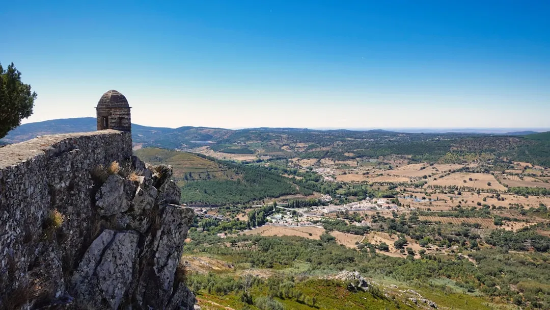
Miradouro do Ninho da Manta: Located just 1.2 km from the start, this "Buzzard’s Nest" viewpoint is where many photographers gather for sunrise. It offers a spectacular view of the Ribeira da Metade valley and, on clear days, the Saint Lawrence Peninsula (Ponta de São Lourenço) in the far east.
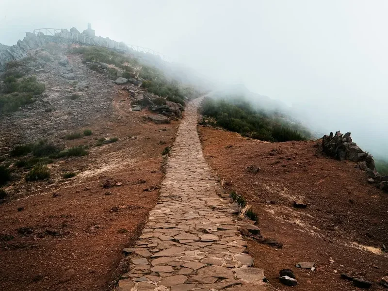
The "Stairway to Heaven": This is the informal name for the steep set of stairs located shortly after Ninho da Manta. It is one of the most photographed spots on the island, where the narrow stone steps seem to disappear into the clouds. It is a test of both legs and nerves.
Pico do Gato Tunnel: The longest tunnel on the trail, it cuts directly through a volcanic plug. Walking through it feels like entering another world, as you transition from the sun-drenched southern slopes to the cooler, more rugged northern face of the mountain.
The White Heather Forest: Near the base of Pico Ruivo, you will walk through a grove of ancient Erica arborea. These trees are hundreds of years old. Although many were scorched in previous fires, their silver-white trunks against the red volcanic soil and green ferns create a hauntingly beautiful, prehistoric atmosphere.
Achada do Teixeira (PR1.2): If you choose not to walk back to Arieiro, the 2.8 km descent to Achada do Teixeira is a worthy "side trip." It passes the "Homem em Pé" (Standing Man), a unique basalt rock formation that resembles a human figure. This route is much flatter and easier than the PR1.
Leave No Trace
The Central Mountain Massif is a fragile ecosystem home to species found nowhere else on Earth. The high-altitude environment is slow to recover from human impact. As a visitor, you have a responsibility to protect this UNESCO-recognised landscape.
Leave No Trace Principles for Madeira:
- Pack it in, pack it out: There are no rubbish bins on the trail. This includes organic waste like banana peels or orange skins, which decompose very slowly in the thin mountain air and can encourage invasive rodents.
- Stay on the designated path: Stepping off the trail to get a "better photo" crushes endemic high-altitude plants and contributes to soil erosion on steep slopes.
- Respect the wildlife: Do not feed the Berthelot's Pipits or the Madeiran Chaffinches that frequent the rest areas. Human food is harmful to their health and makes them dependent on hikers.
- No drones without permits: Drones can disturb the nesting sites of the endangered Zino’s Petrel. Official permits are required for drone use in the National Park.
- Sanitation: Use the toilets at the trailheads or the Pico Ruivo hut. If you are caught short, ensure you are at least 50 metres from the trail and any water drainage areas, and pack out your toilet paper in a sealed bag.
- Silence: Keep noise levels low to allow others to enjoy the natural sounds of the mountains and to avoid startling the birdlife.