Trilha do Pico do Papagaio - A Challenging Ascent in Minas Gerais
The Trilha do Pico do Papagaio, or Parrot's Peak Trail, is a demanding day hike located in the heart of Minas Gerais, Brazil. This trail offers a significant physical challenge, culminating in a rewarding summit with panoramic views of the surrounding Serra do Curral mountain range. Known for its steep ascents and rugged terrain, the hike is a popular choice for experienced trekkers seeking an adventure close to the historic city of Ouro Preto. The trail winds through diverse vegetation, transitioning from dense forest to more exposed rocky outcrops as it gains altitude. Reaching the summit of Pico do Papagaio requires stamina and determination, but the breathtaking vistas and sense of accomplishment make it a truly memorable experience.
- Distance: 9.0 km one-way
- Elevation Gain: 950 m
- Duration: 6-8 hours
- Difficulty: Challenging
- Best Time: April to September (dry season)
- Closest City: Ouro Preto
- Trailhead Access: From Ouro Preto, take the MG-505 towards Lavras Novas. Drive ~20km. Trailhead is on the left, marked by a sign. Road is paved, but may have potholes. Parking available. No permits required.
- Coordinates: -20.4118, -43.5004
Overview
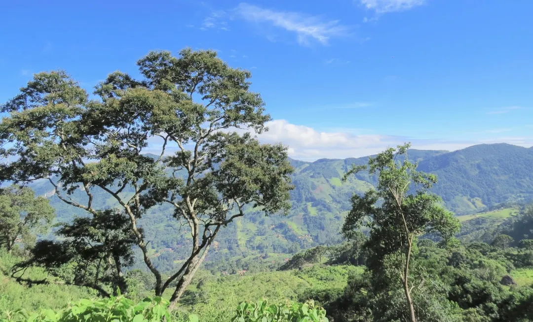
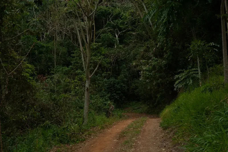
The Trilha do Pico do Papagaio is a testament to the rugged beauty of Minas Gerais's mountainous terrain. This challenging day hike is not for the faint of heart, demanding a high level of fitness due to its substantial elevation gain packed into a relatively short distance. The trail begins at a lower elevation, gradually ascending through a rich tapestry of Atlantic Forest vegetation. As you climb, the path becomes increasingly rugged, with sections requiring scrambling over rocks and navigating steep, uneven ground. The air grows cooler and thinner with altitude, and the dense forest canopy eventually gives way to more open, windswept landscapes as you approach the summit ridge.
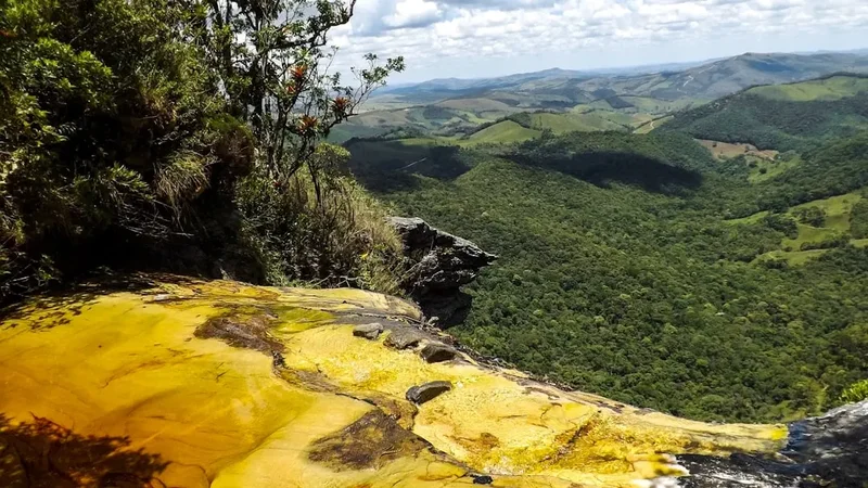
The defining characteristic of this hike is its relentless ascent. Over approximately 4.5 kilometres, you will gain a staggering 950 metres in elevation. This steep gradient means that much of the hike involves a sustained climb, testing your cardiovascular endurance and leg strength. The trail is well-trodden but can be slippery, especially after rain, making sturdy footwear and careful footing essential. The summit itself, Pico do Papagaio, is a dramatic rocky peak that offers spectacular 360-degree views. On a clear day, you can see for miles across the rolling hills and distant mountains of Minas Gerais, including views towards Ouro Preto and the surrounding historic towns. The sense of achievement upon reaching the summit is immense, amplified by the sheer effort required to get there.
The best time to undertake this hike is during the dry season, typically from April to September. During these months, the weather is generally more stable, with less rainfall and clearer skies, which are crucial for enjoying the summit views and for safer navigation. The cooler temperatures of the dry season also make the strenuous climb more bearable. Outside of this period, the rainy season can bring heavy downpours, making the trail muddy, slippery, and potentially dangerous, with reduced visibility at the summit.
History and Cultural Context
The region surrounding Pico do Papagaio, including the historic city of Ouro Preto, is steeped in Brazilian history, particularly the gold rush era of the 18th century. While the trail itself may not have a long documented history as a formal hiking route, the mountains and valleys it traverses have been part of the landscape for centuries, likely used by indigenous peoples and later by settlers and miners. The Serra do Curral, the mountain range to which Pico do Papagaio belongs, has always been a significant geographical feature, shaping settlement patterns and providing resources.
Ouro Preto, a UNESCO World Heritage site, was once the capital of Minas Gerais and a major centre of Brazil's colonial gold production. The wealth generated from this region funded much of Portugal's empire and played a pivotal role in shaping Brazilian identity. The rugged terrain, including the steep slopes and peaks like Pico do Papagaio, presented significant challenges to early explorers and miners. The very existence of towns like Ouro Preto, built on steep hillsides, is a testament to the resilience and ingenuity of the people who settled here.
In more recent times, the natural beauty and challenging terrain of the Serra do Curral have attracted hikers and nature enthusiasts. The Trilha do Pico do Papagaio has become a popular destination for those seeking an active way to experience the region's natural heritage, offering a stark contrast to the historical and architectural wonders of the nearby cities. The trail represents a modern engagement with the landscape, celebrating its wildness and the physical challenge it presents, rather than its historical exploitation.
Seasonal Highlights and Weather Reality
The Trilha do Pico do Papagaio experiences distinct seasonal variations that significantly impact the hiking experience. The most favourable period for this challenging trek is during the dry season, which generally runs from April to September.
Dry Season (April to September): This is the prime time for hiking Pico do Papagaio. The weather is typically more stable, with significantly less rainfall. Days are often sunny and clear, offering excellent visibility from the summit. Temperatures are cooler, making the strenuous climb more comfortable. The trail conditions are generally drier, reducing the risk of slips and falls. However, even in the dry season, mountain weather can be unpredictable, and temperatures at the summit can still be cool, especially in the early morning or late afternoon. It is advisable to check the weather forecast before setting out.
Rainy Season (October to March): This period is characterised by frequent and often heavy rainfall. The trail can become extremely muddy, slippery, and hazardous. Water levels in streams can rise rapidly, and the risk of landslides increases. Visibility at the summit can be severely reduced by clouds and fog, diminishing the panoramic views. While the lush vegetation is at its most vibrant during the rainy season, the increased difficulty and safety risks make it a less ideal time for this particular hike. Experienced hikers with appropriate gear and a high tolerance for challenging conditions might still attempt it, but caution is paramount.
Shoulder Seasons (March/April and September/October): These transitional periods can offer a mix of conditions. You might experience some of the lingering rain from the wet season or the early signs of the dry season's clear skies. It's essential to monitor weather forecasts closely during these months, as conditions can change rapidly.
Recommended Itinerary
Day Hike: Trilha do Pico do Papagaio
Early Morning (Approx. 6:00 AM - 7:00 AM): Departure from Ouro Preto
- Depart from Ouro Preto towards the trailhead.
- The drive takes approximately 30-40 minutes via the MG-505 towards Lavras Novas.
- Ensure you have a full tank of fuel, as services are limited en route.
Morning (Approx. 7:00 AM - 8:00 AM): Arrival at Trailhead and Preparation
- Arrive at the marked trailhead on the left side of the MG-505, approximately 20 km from Ouro Preto.
- Park your vehicle in the designated area.
- Final gear check: ensure boots are tied, water bottles are full, and layers are adjusted.
- Briefly assess the weather conditions.
Morning to Midday (Approx. 8:00 AM - 12:00 PM): Ascent to the Summit
- Begin the hike. The initial section may be through denser forest.
- The trail quickly becomes steep, with significant elevation gain.
- Navigate rocky sections and uneven terrain.
- Take short breaks as needed to hydrate and catch your breath.
- Enjoy the changing vegetation and increasingly expansive views as you gain altitude.
- The final approach to the summit involves a steep scramble over rocks.
Midday (Approx. 12:00 PM - 1:00 PM): Summit Experience
- Reach the summit of Pico do Papagaio.
- Spend time enjoying the 360-degree panoramic views of the Serra do Curral.
- Have your packed lunch and snacks.
- Take photographs and appreciate the accomplishment.
- Be mindful of the weather; conditions can change rapidly at the summit.
Afternoon (Approx. 1:00 PM - 4:00 PM): Descent and Return to Trailhead
- Begin the descent. This can be as challenging as the ascent, requiring careful footing.
- Take your time to navigate the steep and rocky sections safely.
- Continue through the forest back towards the trailhead.
- Arrive back at the trailhead.
Late Afternoon (Approx. 4:00 PM onwards): Return to Ouro Preto
- Drive back to Ouro Preto.
- Consider stopping for a well-deserved meal or drink in Ouro Preto or Lavras Novas.
Important Notes:
- This is a strenuous day hike requiring excellent physical fitness.
- Carry ample water (at least 2-3 litres per person) as there are no water sources on the trail.
- Pack high-energy snacks and a substantial lunch.
- Wear sturdy, broken-in hiking boots with good ankle support.
- Bring layers of clothing, including a waterproof and windproof jacket, as mountain weather can change quickly.
- Sun protection (hat, sunglasses, sunscreen) is essential, even on cloudy days.
- A basic first-aid kit is recommended.
- Mobile phone signal may be intermittent.
Planning and Bookings
Book Your Trip
Everything you need to plan your journey
Accommodation
Find places to stay near Ouro Preto
Flights
Search flights to Ouro Preto
Essential Preparation
The Trilha do Pico do Papagaio is a challenging day hike that requires careful planning to ensure a safe and enjoyable experience. Given its proximity to Ouro Preto, this historic city serves as the primary base for most hikers. Ouro Preto offers a range of accommodation options, from budget-friendly hostels and guesthouses to more comfortable hotels, catering to various preferences and budgets. It is advisable to book accommodation in advance, especially during peak tourist seasons or local festivals.
Logistics for accessing the trailhead are straightforward but require attention. The trailhead is located approximately 20 kilometres from Ouro Preto via the MG-505 road towards Lavras Novas. While the road is paved, it can be in variable condition with potholes, so driving with caution is recommended. Parking is available at the trailhead, but it is advisable to arrive early, particularly on weekends, as spaces can fill up. For those without a private vehicle, hiring a taxi or arranging a private transfer from Ouro Preto is a viable option, though it will be more expensive. Ensure your vehicle has sufficient fuel, as services are limited along the route.
Fitness is paramount for this hike. The 950 metres of elevation gain over 9 kilometres (round trip) is significant and demands good cardiovascular health and strong leg muscles. It is recommended to undertake regular cardiovascular exercise and strength training in the weeks leading up to the hike. Familiarity with hiking on uneven and rocky terrain is also beneficial.
Trail Accommodation
This is a day hike requiring no overnight accommodation.
Required Gear
- Hiking Boots: Sturdy, waterproof hiking boots with good ankle support are essential. Ensure they are well broken-in to prevent blisters.
- Backpack: A comfortable daypack (20-30 litres) to carry essentials. A rain cover for the backpack is advisable.
- Clothing Layers: Moisture-wicking base layers, an insulating mid-layer (fleece or down jacket), and a waterproof and windproof outer shell jacket. Mountain weather can change rapidly.
- Trousers: Durable hiking trousers that allow for freedom of movement. Avoid jeans.
- Headwear: A sun hat or cap for protection from the sun, and a warm hat or beanie for cooler temperatures at higher altitudes.
- Gloves: Lightweight gloves can be useful for cooler conditions or for added grip on rocky sections.
- Navigation: A map of the area and a compass, or a GPS device/smartphone with offline maps downloaded. While the trail is generally well-defined, it's always wise to have navigation tools.
- Head Torch: Essential, even for a day hike, in case of unexpected delays or if starting very early/finishing late. Ensure it has fresh batteries.
- First-Aid Kit: A comprehensive kit including blister treatment, bandages, antiseptic wipes, pain relievers, and any personal medications.
- Sun Protection: High SPF sunscreen, sunglasses.
What to Bring
- Water: Carry at least 2-3 litres of water per person. There are no reliable water sources on the trail.
- Food: High-energy snacks (nuts, dried fruit, energy bars) and a substantial packed lunch.
- Toiletries: Hand sanitiser, biodegradable toilet paper (pack out used paper), any personal hygiene items.
- Insect Repellent: While not as notorious as some other Brazilian regions, insects can be present, especially in forested areas.
- Camera: To capture the stunning views from the summit.
- Trekking Poles: Optional, but can be very helpful for stability and reducing strain on knees during the steep ascent and descent.
- Small Towel: Useful for wiping sweat or if caught in unexpected rain.
- Cash: For potential parking fees or for purchasing refreshments in Ouro Preto or Lavras Novas afterwards.
Permits
No specific permits are required to hike the Trilha do Pico do Papagaio. The trail is located on public land, and access is generally free. However, it is always advisable to check for any local regulations or temporary restrictions that may be in place, especially if visiting during a major local event or festival.
While no permits are needed, responsible hiking practices are expected. This includes staying on marked trails, not littering, and respecting the natural environment. The area is part of the broader Serra do Curral landscape, which holds ecological significance.
Important Considerations:
- Trailhead Access: Ensure you have a reliable way to reach the trailhead. The MG-505 road is the primary access route.
- Parking: Parking is available at the trailhead, but it can be limited on busy days. Arrive early to secure a spot.
- Local Information: If you are unsure about current conditions or access, it is a good idea to inquire at your accommodation in Ouro Preto or at a local tourist information point.
Other Activities in the Area
The region around Ouro Preto and Pico do Papagaio offers a wealth of activities beyond the challenging hike:
- Explore Ouro Preto: Wander through the cobblestone streets of this UNESCO World Heritage city, visit its historic churches (like Igreja de São Francisco de Assis and Matriz de Nossa Senhora do Pilar), museums, and colonial architecture.
- Visit Mariana: Discover Brazil's oldest city, located a short drive from Ouro Preto, with its own rich history, beautiful churches, and charming atmosphere.
- Lavras Novas: This small, picturesque village near the trailhead is known for its natural springs, waterfalls, and a more relaxed, bohemian vibe. It's a good place to stop for a meal or a drink after your hike.
- Cachoeira do Tabuleiro: For those seeking more waterfall adventures, this impressive waterfall is located a longer drive away but is one of the most spectacular in Minas Gerais.
- Museu de Ciência e Técnica da Escola de Minas: Located in Ouro Preto, this museum offers fascinating insights into geology, mining, and science, relevant to the region's history.
- Gastronomy: Indulge in the delicious cuisine of Minas Gerais, known for its hearty dishes, cheeses, and sweets. Try local specialities like pão de queijo, feijão tropeiro, and doce de leite.
- Artisan Markets: Browse local craft markets in Ouro Preto for unique souvenirs, including soapstone carvings and jewellery.
Safety and Conditions
Trail Conditions: The Trilha do Pico do Papagaio is a challenging hike with steep ascents and descents. The trail surface is uneven, rocky, and can be slippery, especially after rain. Loose rocks are common, so careful footing is essential. The trail is generally well-defined, but in poor visibility, it is possible to lose the path. Always stay on the marked trail.
Weather: Mountain weather can change rapidly. Be prepared for sudden shifts in temperature, wind, and precipitation. Even on a clear morning, clouds can roll in quickly, reducing visibility and making the summit hazardous. Check the weather forecast before you go and be prepared to turn back if conditions deteriorate.
Fitness Level: This hike is rated as challenging due to the significant elevation gain (950 metres) over a relatively short distance. A good level of cardiovascular fitness and leg strength is required. If you are not accustomed to strenuous hiking, consider a less demanding trail first.
Hydration and Nutrition: Carry ample water (at least 2-3 litres per person) as there are no water sources on the trail. Pack high-energy snacks and a substantial lunch to maintain your energy levels throughout the hike. Dehydration and fatigue can increase the risk of accidents.
Navigation: While the trail is generally clear, it is advisable to carry a map and compass or a GPS device with offline maps. Mobile phone signal can be intermittent in the area.
Wildlife: While large dangerous animals are not a common concern on this trail, be aware of smaller wildlife and insects. The primary nuisance can be biting insects, so insect repellent is recommended.
Emergency: Inform someone of your hiking plans, including your expected return time. In case of an emergency, try to stay calm and use your mobile phone if you have signal. If not, consider sending someone for help if possible, or wait for assistance. The trailhead is accessible by vehicle, which can be helpful for emergency services.
Personal Locator Beacon (PLB): For added safety, especially if hiking solo or in remote conditions, consider carrying a PLB.
Side Trips and Points of Interest
While the Trilha do Pico do Papagaio is primarily a single, challenging day hike, the surrounding region offers several points of interest and potential short detours that can enhance your experience:
Lavras Novas Village: Located on the route to the trailhead, this charming village offers a pleasant stop before or after your hike. It's known for its natural springs, small waterfalls, and a relaxed atmosphere. You can find local eateries for a meal or a refreshing drink. It provides a good contrast to the strenuous hike.
Scenic Drive on MG-505: The drive itself from Ouro Preto to the trailhead offers beautiful views of the Minas Gerais countryside. The road winds through rolling hills and rural landscapes, providing glimpses of the Serra do Curral. Take your time to appreciate the scenery.
Viewpoints along the Trail: As you ascend Pico do Papagaio, there are numerous points where the vegetation opens up, offering increasingly spectacular views of the surrounding valleys and mountains. These natural viewpoints are perfect for short breaks to rest, hydrate, and admire the expanding panorama.
Geological Formations: The trail passes through interesting geological formations characteristic of the Serra do Curral. Keep an eye out for unique rock structures and mineral deposits that tell the story of the region's geological past.
Ouro Preto's Historic Centre: Although not a side trip directly on the trail, spending time exploring Ouro Preto before or after your hike is highly recommended. Its well-preserved colonial architecture, numerous churches, and museums offer a deep dive into Brazil's rich history and culture.
Leave No Trace
The Trilha do Pico do Papagaio traverses a beautiful natural landscape that deserves our utmost respect and care. Adhering to Leave No Trace principles ensures that this trail remains a pristine and enjoyable experience for all visitors, now and in the future.
Your responsibility as a hiker:
- Pack It In, Pack It Out: Carry out everything you carry in. This includes all food wrappers, fruit peels, and any other waste. Do not bury or burn trash.
- Stay on the Trail: Stick to the marked path to avoid damaging fragile vegetation and to prevent erosion. Creating new paths can lead to long-term environmental damage.
- Respect Wildlife: Observe wildlife from a distance and never feed them. Feeding animals can alter their natural behaviour and diet, and can be harmful to their health.
- Dispose of Waste Properly: Use designated toilets where available. If no facilities are present, dig a cathole at least 60 metres (60 m) away from water sources, trails, and campsites. Pack out all toilet paper.
- Leave What You Find: Do not take rocks, plants, or any natural objects from the environment. Leave them for others to enjoy and for the ecosystem to thrive.
- Minimise Campfire Impacts: Campfires are generally not permitted on day hikes and should be avoided. If camping is permitted in the area (which it is not for this day hike), use established fire rings and keep fires small.
- Be Considerate of Other Visitors: Keep noise levels down and yield to other hikers on the trail. Respect the experience of others seeking solitude and enjoyment of nature.
By following these principles, you help preserve the natural beauty and ecological integrity of the Pico do Papagaio area.
Useful Links
- Official Tourism Website of Ouro Preto
- General Information on Hiking in Minas Gerais (Governmental)
- Climatempo - Weather Forecast for Ouro Preto
- MetService - Fiordland mountain forecast (Note: This is a placeholder from the template, not relevant to Brazil)
- Waze Navigation to Pico do Papagaio Trailhead
- TripAdvisor - Ouro Preto Activities