Trilha do Pico do Itapeva - A Summit Viewpoint Trail
The Trilha do Pico do Itapeva is a relatively short but rewarding day walk located near the charming mountain city of Campos do Jordão in Brazil. This trail leads to the summit of Pico do Itapeva, one of the highest points in the region, offering breathtaking panoramic views that stretch across multiple municipalities and even into neighbouring states on a clear day. The trail is well-maintained and accessible, making it a popular choice for both local residents and tourists seeking a taste of the Serra da Mantiqueira's natural beauty without an arduous trek. It's a perfect excursion for those who appreciate stunning vistas and a moderate physical challenge.
- Distance: 6.0 km (round trip)
- Duration: 2-3 hours
- Season: All year round, but best during dry periods for clear views.
- Difficulty: Easy to Moderate
- Highest point: Pico do Itapeva summit (approx. 2,000 m)
- Access: Via paved and unpaved roads from Campos do Jordão
- Permits: Not required
Overview
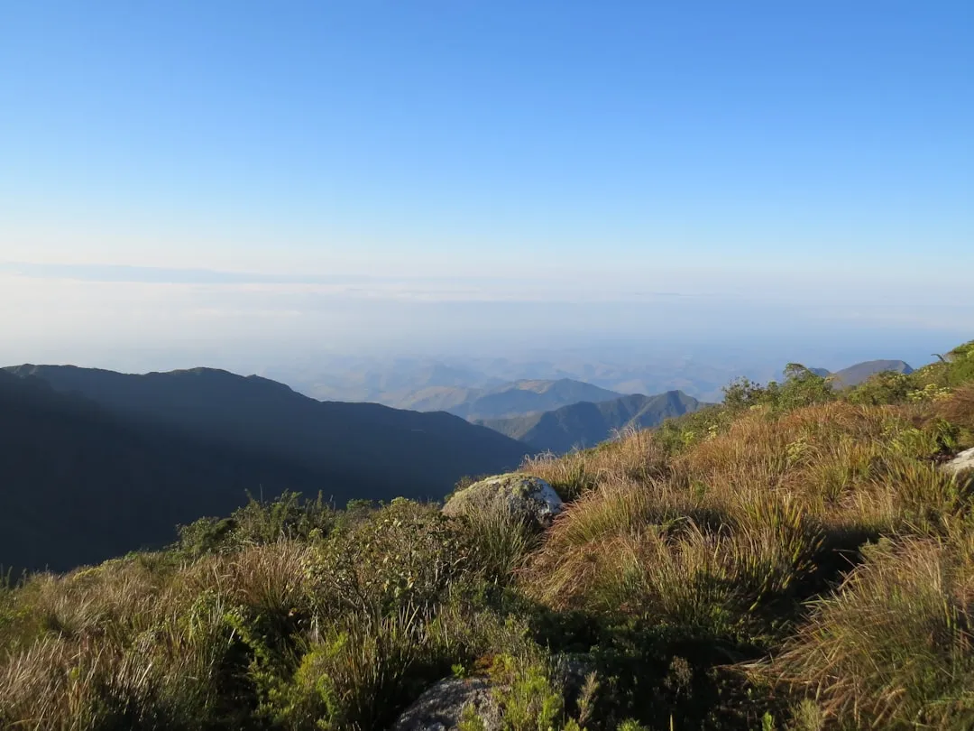
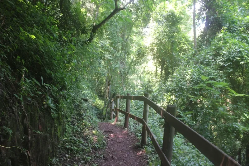
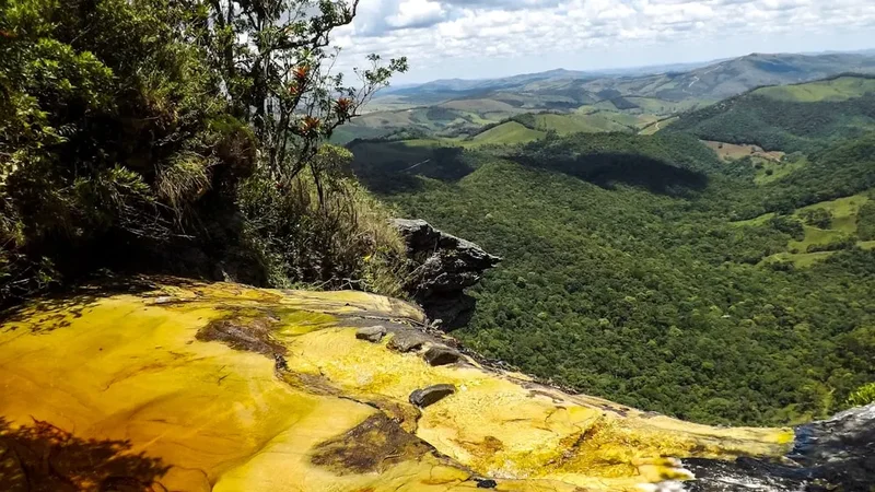
The Trilha do Pico do Itapeva is a testament to the expansive beauty of the Brazilian highlands. The trail itself is not overly demanding, making it suitable for a wide range of fitness levels. It begins with a gentle ascent, gradually winding through the natural landscape that characterises the Serra da Mantiqueira mountain range. As you climb, the vegetation transitions, offering glimpses of the surrounding forests and the unique flora of the region. The primary draw, however, is the summit itself. Upon reaching Pico do Itapeva, walkers are greeted with an unparalleled 360-degree vista. On a clear day, the view encompasses a vast expanse of rolling hills, distant cities, and the intricate tapestry of the Brazilian countryside. The feeling of standing atop such a prominent peak, with the world seemingly spread out beneath you, is truly memorable. The trail's accessibility from Campos do Jordão, a popular tourist destination known for its European-inspired architecture and cool climate, makes it an ideal addition to any itinerary.
The experience is amplified by the changing light throughout the day. Sunrise can paint the sky with vibrant colours, while sunset offers a warm, golden glow over the landscape. Midday provides the clearest, most far-reaching views, though it can also be the busiest time. The trail's relatively short distance and manageable elevation gain mean that the focus remains on the destination – the spectacular summit views – rather than the journey itself being an endurance test. This makes it an excellent option for families or those with limited time who still wish to experience the grandeur of the region's highest points.
The trail is primarily a walking path, often with a well-trodden surface. While not technically challenging, sturdy footwear is recommended due to the uneven terrain in some sections. The summit area is typically open and exposed, so visitors should be prepared for varying weather conditions, including wind and sun. The journey back down offers a different perspective on the landscape, allowing for a more relaxed appreciation of the surroundings.
History and Cultural Context
The history of Pico do Itapeva is intrinsically linked to the development of Campos do Jordão and the broader region of the Serra da Mantiqueira. This mountain range has long been a natural barrier and a source of natural resources, with indigenous populations likely traversing its peaks for centuries. However, the modern history of Pico do Itapeva as a destination for tourism and recreation began with the rise of Campos do Jordão as a health resort and summer retreat in the early 20th century.
Campos do Jordão gained prominence as a sanatorium town, attracting those seeking relief from respiratory ailments due to its high altitude and clean air. As the town developed into a popular destination, its surrounding natural attractions, including the peaks like Pico do Itapeva, began to be explored and promoted. Early visitors and residents would have ventured to these viewpoints for their scenic beauty and the therapeutic benefits of being in nature.
The name "Itapeva" itself likely has indigenous origins, possibly Tupi-Guarani, reflecting the historical presence of native peoples in the area. While specific historical accounts of the trail's creation are scarce, it is understood that local communities and early tourism initiatives gradually established and maintained the paths leading to the summit to facilitate access for visitors. The development of roads, including the route leading towards the peak, further enhanced its accessibility in the latter half of the 20th century.
Today, Pico do Itapeva is a symbol of the natural heritage of the region. It represents a place where natural beauty meets human endeavour, offering a connection to the landscape that has captivated visitors for generations. The trail continues to be a focal point for tourism, drawing people to experience the panoramic vistas that have made this peak famous.
Seasonal Highlights and Weather Reality
The Trilha do Pico do Itapeva is accessible and enjoyable throughout the year, but the experience can vary significantly depending on the season and weather conditions.
Dry Season (April to September): This period generally offers the clearest skies and the most stable weather, making it the ideal time to visit for maximum visibility. The air is crisp, and the temperatures are cool, often ranging between 10°C and 20°C during the day. This season is perfect for enjoying the expansive panoramic views without the obstruction of clouds or fog. However, it can also be the busiest time, especially during weekends and holidays, as many people flock to Campos do Jordão.
Rainy Season (October to March): This period is characterised by higher humidity and more frequent rainfall. While the rain can bring lush greenery to the landscape, it often leads to cloud cover and fog that can obscure the summit views. If you plan to visit during these months, it's advisable to check the weather forecast carefully and be prepared for the possibility of limited visibility. Despite the rain, the trails remain walkable, and the cooler temperatures can be pleasant. Occasionally, even during the rainy season, there can be periods of clear weather, offering spectacular, albeit potentially fleeting, views.
Temperature Considerations: Even during the warmer months, temperatures at the summit can be cooler due to the altitude and potential for wind. It's always advisable to bring layers of clothing. In the dry season, mornings and evenings can be quite chilly, often dropping below 10°C.
Recommendation: For the best chance of clear, unobstructed views, aim for the dry season. However, if you visit during the rainy season, embrace the possibility of dramatic, misty landscapes, which can also be incredibly beautiful and atmospheric.
Recommended Itinerary
Day Walk: Trilha do Pico do Itapeva
Early Morning: Departure from Campos do Jordão
- Begin your journey from Campos do Jordão.
- Drive towards the Hotel Pico Itapeva, following signs for the trail. The drive itself offers scenic views of the surrounding countryside.
- Estimated drive time: 20-30 minutes.
Morning: Arrival at Trailhead and Ascent
- Arrive at the designated parking area near the base of the trail.
- Begin the hike. The trail is approximately 3 km to the summit.
- The initial part of the trail is relatively gentle, gradually increasing in gradient.
- Enjoy the changing vegetation and the fresh mountain air.
- Keep an eye out for local flora and fauna.
Midday: Summit Experience
- Reach the summit of Pico do Itapeva.
- Spend ample time taking in the panoramic views. Identify landmarks and enjoy the vastness of the landscape.
- This is an excellent time for photography.
- If you have packed snacks or a light lunch, this is the ideal spot to enjoy them.
- Note: The summit can be windy, so be prepared.
Afternoon: Descent and Return
- Begin the descent back to the trailhead.
- The descent is generally quicker and less strenuous than the ascent.
- Take your time to appreciate the views you might have missed on the way up.
- Return to your vehicle at the trailhead.
- Drive back to Campos do Jordão, perhaps stopping at a local café or restaurant to reflect on your hike.
Important Notes:
- Wear comfortable, sturdy walking shoes.
- Bring water and snacks, as facilities at the summit are limited.
- Carry sunscreen, a hat, and insect repellent, especially during warmer months.
- Check the weather forecast before you go; avoid hiking on very rainy or foggy days if clear views are your priority.
- The trail is generally well-marked, but a basic map or GPS can be helpful.
Planning and Bookings
Book Your Trip
Everything you need to plan your journey
Accommodation
Find places to stay near Campos do Jordão
Flights
Search flights to Campos do Jordão
Essential Preparation
The Trilha do Pico do Itapeva is a day hike, meaning no overnight accommodation is required. The primary logistical consideration is reaching the trailhead from Campos do Jordão. The nearest city, Campos do Jordão, is a well-established tourist destination with a range of accommodation options, from charming pousadas to more luxurious hotels. It is also equipped with supermarkets, pharmacies, and outdoor gear shops, should you need any last-minute supplies.
Access to the trailhead is typically via private vehicle or taxi. The road leading to the vicinity of Pico do Itapeva is mostly paved, though some sections may be unpaved or in poorer condition, especially closer to the summit area. It is advisable to have a vehicle capable of handling varied road surfaces, or to arrange transport with a local guide or taxi service familiar with the route. Parking is available at the base of the trail, though it can be limited during peak seasons.
Given that this is a day hike, the planning is relatively straightforward. The main focus should be on ensuring you have appropriate gear for the weather and the hike itself, and that you have a reliable way to reach the trailhead and return to Campos do Jordão.
Trail Accommodation
This is a day hike requiring no overnight accommodation.
Required Gear
- Footwear: Sturdy, comfortable walking shoes or hiking boots with good grip are essential. Trails can be uneven and sometimes slippery, especially after rain.
- Clothing: Wear comfortable, breathable clothing suitable for hiking. Layers are recommended, as temperatures can change with altitude and weather. A waterproof and windproof jacket is advisable, even on seemingly clear days, as mountain weather can be unpredictable.
- Navigation: While the trail is generally well-marked, a basic map of the area or a GPS device/smartphone with offline maps is recommended for orientation.
- Safety Gear: A basic first-aid kit including plasters, antiseptic wipes, pain relievers, and any personal medications is crucial. A fully charged mobile phone is recommended for emergencies, though signal strength can be variable.
- Sun Protection: Sunscreen (SPF 30 or higher), a wide-brimmed hat, and sunglasses are important, especially at higher altitudes where the sun's rays are more intense.
What to Bring
- Water: Carry at least 1-2 litres of water per person. Staying hydrated is important, especially during the ascent.
- Food: Pack snacks such as energy bars, fruit, nuts, or sandwiches. There are no food facilities at the summit.
- Backpack: A small to medium-sized daypack to carry your essentials.
- Insect Repellent: Especially important during warmer months and near vegetated areas.
- Camera: To capture the stunning panoramic views from the summit.
- Cash: For potential parking fees or local purchases in Campos do Jordão.
- Toiletries: Hand sanitiser and any personal hygiene items.
Permits
No specific permits are required to access and hike the Trilha do Pico do Itapeva. The trail is generally open to the public, and access is free of charge. This makes it a very accessible and popular destination for day visitors.
However, it is always advisable to check for any local regulations or temporary access restrictions that might be in place, particularly if visiting during a major local event or festival. Information can usually be obtained from the tourist information centres in Campos do Jordão.
The area around Pico do Itapeva is part of the natural landscape of the Serra da Mantiqueira, and visitors are expected to respect the environment and follow general guidelines for responsible outdoor recreation.
Other Activities in the Area
Campos do Jordão and its surroundings offer a wealth of activities for visitors:
- Explore Campos do Jordão: Wander through the charming streets of Vila Capivari, known for its Swiss-Bavarian architecture, artisan shops, chocolate factories, and excellent restaurants.
- Horto Florestal (Forest Garden): A large ecological park offering walking trails, picnic areas, and opportunities for birdwatching and enjoying nature.
- Palácio Boa Vista: The official residence of the Governor of São Paulo, which also houses an impressive art museum featuring works by Brazilian artists.
- Museu Felícia Leirner: An open-air sculpture museum set in a beautiful garden, showcasing the works of artist Felícia Leirner.
- Pedra do Baú: For the more adventurous, the Pedra do Baú complex offers challenging hiking and climbing opportunities with spectacular views.
- Gastronomy: Indulge in the local cuisine, which includes fondue, German sausages, and delicious chocolates, reflecting the European influence in the region.
- Winter Festival: If visiting during July, experience the renowned International Festival of Classical Music, which attracts renowned musicians and orchestras.
Safety and Conditions
Trail Conditions: The Trilha do Pico do Itapeva is generally a well-trodden path. However, sections can be uneven, rocky, or muddy, especially after rainfall. It is advisable to wear appropriate footwear with good grip.
Weather: Mountain weather can change rapidly. Be prepared for variations in temperature, wind, and precipitation. Even on a sunny day, it can become cool and windy at the summit. Check the weather forecast before you depart and carry layers of clothing.
Hydration and Nutrition: Carry sufficient water and snacks. There are no facilities along the trail or at the summit. Dehydration can occur quickly, especially during warmer months or with strenuous activity.
Navigation: While the trail is relatively straightforward, it's always wise to have a map or GPS device, especially if you plan to explore any less-defined paths. Inform someone of your hiking plans, including your expected return time.
Wildlife: Be aware of local wildlife. While large dangerous animals are uncommon, it's best to observe wildlife from a distance and avoid feeding them.
Emergency Contacts: Ensure your mobile phone is fully charged. Save local emergency numbers, such as police and ambulance services, in your phone. In Brazil, the general emergency number is 190 for Police and 192 for Ambulance.
Altitude: Pico do Itapeva is at a significant altitude (around 2,000 metres). While most people adapt well, some may experience mild altitude sickness. Take it easy on the ascent, stay hydrated, and be aware of any symptoms like headaches or dizziness.
Side Trips and Points of Interest
The Summit Viewpoint: The primary point of interest is, of course, the summit of Pico do Itapeva itself. The 360-degree panoramic view is the main attraction. On a clear day, you can see for hundreds of kilometres, encompassing cities like Taubaté, Pindamonhangaba, and even parts of the state of Rio de Janeiro. The sheer scale of the vista is awe-inspiring.
Hotel Pico Itapeva Vicinity: The road leading to the trailhead passes by the Hotel Pico Itapeva. While not a side trip in itself, the hotel's location offers a convenient landmark and a point of reference for accessing the trail. The surrounding area also provides opportunities for enjoying the mountain scenery.
Flora and Fauna: The trail winds through the natural vegetation of the Serra da Mantiqueira. Keep an eye out for the diverse plant life, which can include various species of trees, shrubs, and wildflowers, depending on the season. Birdwatching can also be rewarding, with several species native to the Atlantic Forest biome present in the region.
Lookout Points along the Access Road: The drive to the trailhead offers several informal lookout points where you can pause to admire the landscape. These spots provide different perspectives of the valleys and mountains leading up to Pico do Itapeva.
Leave No Trace
The Trilha do Pico do Itapeva traverses a beautiful natural environment, and it is essential for all visitors to practice Leave No Trace principles to preserve its beauty and ecological integrity for future generations.
Plan Ahead and Prepare: Familiarise yourself with the trail conditions and weather forecast before you go. Pack appropriately for the conditions and carry all necessary supplies.
Travel and Camp on Durable Surfaces: Stick to the marked trail. Avoid walking on fragile vegetation or creating new paths, which can lead to erosion and habitat damage.
Dispose of Waste Properly: Pack out everything you pack in. This includes all food scraps, wrappers, and any other litter. Use designated waste bins if available, but be prepared to carry your rubbish back to Campos do Jordão if necessary.
Leave What You Find: Do not remove any natural objects, such as rocks, plants, or flowers. Take only photographs and memories.
Minimise Campfire Impacts: Campfires are generally not permitted on day hikes and are not relevant for this trail. If you were to camp in the wider region, always use established fire rings and ensure fires are completely extinguished.
Respect Wildlife: Observe wildlife from a distance. Do not feed animals, as this can disrupt their natural behaviours and diets, and can make them dependent on human food sources.
Be Considerate of Other Visitors: Keep noise levels down and yield to other hikers on the trail. Respect the peaceful enjoyment of nature for everyone.