Trilha do Pico do Barbado - The Roof of Bahia
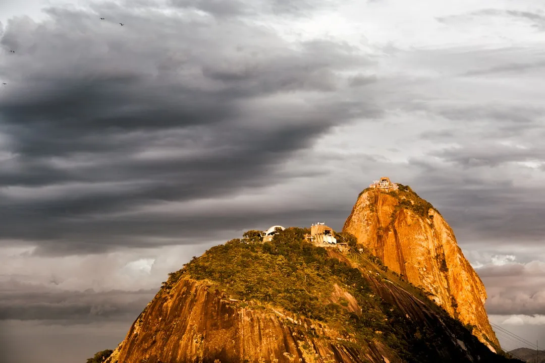
The Trilha do Pico do Barbado is a challenging mountain trek located in the heart of the Chapada Diamantina National Park, in the state of Bahia, Brazil. It leads to the summit of Pico do Barbado, the highest point in Bahia, offering breathtaking panoramic views of the surrounding cerrado and caatinga biomes. This trail is not for the faint-hearted, demanding good physical condition, navigational skills, and a spirit of adventure. The journey takes you through diverse landscapes, from dry scrubland to higher altitude plateaus, with the final ascent being a steep, rocky climb. It's a true test of endurance and a rewarding experience for those seeking to conquer the highest peak in the region.
- Distance: 18.0 km (one-way to summit and return)
- Duration: 1-2 days
- Season: May to September (dry season)
- Difficulty: Challenging
- Highest point: Pico do Barbado (2,033 m)
- Access: Via Lençóis, then local transport to trailhead
- Accommodation: Basic camping or local pousadas in nearby villages
Overview
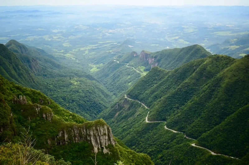
The Trilha do Pico do Barbado is a significant undertaking, often considered one of the most demanding hikes in Bahia. The trail begins in a region characterised by dry, scrubby vegetation typical of the caatinga biome, gradually transitioning to the more open, grassy plateaus of the cerrado as altitude increases. The total distance of 18.0 km is deceptive; the significant elevation gain of 900 metres, coupled with the often harsh sun and potential for strong winds, makes this a strenuous trek. The final push to the summit is a scramble over rocky terrain, requiring careful foot placement and a steady nerve.
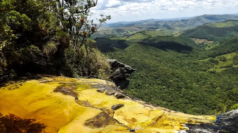
The landscape is starkly beautiful. During the dry season, the vegetation appears parched, but the resilience of life in this environment is remarkable. As you ascend, the views expand dramatically. From the summit of Pico do Barbado, on a clear day, you can see for miles, encompassing the vast expanse of the Chapada Diamantina plateau, with its distinctive tabletop mountains and deep valleys. The feeling of accomplishment upon reaching the highest point in the state is immense, offering a profound connection to the natural grandeur of Bahia.
This trail is best undertaken with a local guide who is familiar with the terrain, weather patterns, and potential hazards. While the path is generally discernible, especially in the lower sections, the higher reaches can be less defined, and navigation can be tricky, particularly in poor visibility. The experience is one of raw, untamed nature, a stark contrast to more manicured tourist trails, offering a genuine sense of exploration and self-reliance.
History and Cultural Context
The Chapada Diamantina region, including the area around Pico do Barbado, has a rich history deeply intertwined with indigenous peoples and later, diamond mining. For centuries, indigenous tribes such as the Maracá and Cariri inhabited these highlands, utilising the natural resources and navigating the complex terrain. Their knowledge of the land, its flora, and fauna was extensive, and many of the routes they used likely formed the basis for later trails.
During the 19th century, the discovery of diamonds in the region led to a diamond rush, attracting prospectors and transforming small settlements into bustling mining towns. Lençóis, the closest major town to the Pico do Barbado trailhead, was once a thriving centre of diamond extraction. While the mining era has largely passed, the legacy of this period can still be seen in the architecture of the towns and the stories of the people who lived and worked here. The trails themselves were often used by these miners and explorers to traverse the rugged landscape, seeking new diamond deposits.
Pico do Barbado, as the highest point, would have been a significant landmark for these early inhabitants and explorers. Its name, "Bearded Peak," likely refers to the appearance of the summit or its surrounding rock formations, perhaps resembling a beard. The mountain and its surroundings hold a natural and historical significance, representing a frontier of exploration and a testament to the enduring power of the natural environment.
Seasonal Highlights and Weather Reality
The best time to undertake the Trilha do Pico do Barbado is during the dry season, which typically runs from May to September. During these months, rainfall is significantly reduced, making the trails more accessible and reducing the risk of flash floods or impassable conditions.
Dry Season (May to September): This period offers the most favourable conditions for hiking. Days are generally sunny, though temperatures can be cooler, especially at higher altitudes and during the night. The landscape can appear parched, but the skies are often clear, providing excellent visibility for the expansive views from the summit. Evenings can be cool, so warm layers are essential. This is the peak season for trekking in the region.
Wet Season (October to April): This period is characterised by higher humidity and more frequent, often heavy, rainfall. While the landscape is greener and more vibrant, the trails can become muddy, slippery, and potentially dangerous. Rivers and streams can swell rapidly, posing a risk of flash floods. Visibility can be severely reduced by clouds and fog, making navigation difficult and obscuring the spectacular views. While some may find the lushness appealing, the practical challenges and safety concerns make this season less ideal for attempting the Pico do Barbado summit.
Regardless of the season, weather in the Chapada Diamantina can be unpredictable. Even during the dry season, sudden rain showers can occur, and temperatures can fluctuate significantly between day and night, and with altitude. It is crucial to be prepared for a range of conditions at all times.
Recommended Itinerary

1-Day Pico do Barbado Summit Attempt
Early Morning (Approx. 05:00 - 06:00): Departure from Lençóis/Nearby Village
- Begin the journey from Lençóis or a closer village like Igatu or Mucugê (depending on your base).
- Hire a 4x4 vehicle and local guide. The drive to the trailhead can take 2-3 hours on unpaved, rough roads.
- Ensure you have had a substantial breakfast and are carrying sufficient water and snacks.
Morning (Approx. 08:00 - 09:00): Trailhead Arrival and Start of Hike
- Arrive at the approximate trailhead area (coordinates: -13.32000000, -41.75000000).
- Final gear check, apply sunscreen and insect repellent.
- Begin the ascent. The initial part of the trail is relatively gentle, passing through dry scrubland and open cerrado.
- Distance covered: ~3-5 km.
- Elevation gain: ~200-300 m.
Midday (Approx. 11:00 - 13:00): Ascending to Higher Plateaus
- The terrain becomes steeper and rockier.
- You will start to gain significant altitude, and the vegetation may change to more hardy, low-lying plants.
- Views of the surrounding landscape begin to open up.
- Take a break for lunch and rehydrate.
- Distance covered: ~6-8 km from trailhead.
- Elevation gain: ~500-600 m from trailhead.
Afternoon (Approx. 13:00 - 16:00): Summit Push and Descent
- The final ascent to Pico do Barbado (2,033 m). This section is the most challenging, involving scrambling over rocks and navigating steep inclines.
- Reach the summit and enjoy the panoramic views. Spend time taking photos and appreciating the accomplishment.
- Begin the descent. The descent can be as taxing as the ascent, requiring careful footing to avoid slips and falls.
- Distance covered: ~9 km (summit) and begin descent.
- Elevation gain: 900 m to summit.
Late Afternoon/Evening (Approx. 17:00 - 20:00): Return to Trailhead and Departure
- Continue descending back to the trailhead.
- Meet your waiting 4x4 vehicle.
- Drive back to Lençóis or your accommodation.
- Distance covered: 18.0 km total.
2-Day Pico do Barbado Expedition (Recommended for a more relaxed pace)
Day 1: Trailhead to Campsite/Basic Shelter
- Morning: Drive from Lençóis to the trailhead.
- Late Morning/Midday: Begin the hike, covering the initial 6-8 km.
- Afternoon: Reach a suitable camping spot or basic shelter (if available and pre-arranged). This might be a flatter area with access to water, or a designated basic camping zone.
- Set up camp, prepare dinner, and rest for the summit push the next day.
- Distance covered: ~6-8 km.
- Elevation gain: ~500-600 m.
Day 2: Summit Attempt and Return
- Early Morning: Wake up, have breakfast, and pack up camp.
- Summit Push: Ascend the remaining distance to Pico do Barbado (approx. 4-5 km).
- Midday: Reach the summit, enjoy the views, and have lunch.
- Afternoon: Descend back to the trailhead (approx. 9 km).
- Late Afternoon: Meet your vehicle and return to Lençóis.
- Distance covered: ~12-13 km on Day 2.
- Total distance: 18.0 km.
Important Notes:
- A local guide is highly recommended, if not essential, for navigation and safety.
- Carry ample water (at least 3-4 litres per person per day) or a reliable water filter/purification method.
- Be prepared for extreme temperature variations between day and night.
- The trail is exposed to the sun for most of its length; sun protection is critical.
- Inform someone of your hiking plans and expected return time.
Planning and Bookings
Book Your Trip
Everything you need to plan your journey
Accommodation
Find places to stay near Lençóis
Flights
Search flights to Lençóis
Essential Preparation
The Trilha do Pico do Barbado requires thorough preparation due to its challenging nature and remote location. The closest major town and logistical hub is Lençóis. From Lençóis, you will need to arrange transport to the trailhead, which is typically done via a 4x4 vehicle due to the unpaved and often difficult road conditions. This journey can take 2-3 hours. It is highly advisable to hire a local guide who is experienced with the trail, understands the local weather patterns, and can assist with navigation and safety. Booking accommodation in Lençóis or a nearby village before and after your hike is also essential. Ensure you have all necessary gear, food, and water supplies, as amenities are non-existent on the trail itself.
Trail Accommodation
This is a challenging day hike or a short overnight expedition that requires self-sufficiency. There is no formal trail accommodation such as huts or lodges along the Trilha do Pico do Barbado. Hikers typically opt for one of the following:
Day Hike:
- This is a day hike requiring no overnight accommodation. Hikers start early from Lençóis or a nearby village, complete the trek to the summit and back within a single day, and return to their accommodation in the evening.
Overnight Expedition (Recommended):
- Camping: Hikers can carry camping gear and set up a temporary camp at a suitable location along the trail, typically around the halfway point or a flatter area with access to water. This allows for a more relaxed pace and an earlier start for the summit push on the second day. Basic camping involves carrying all your own equipment, including tents, sleeping bags, and cooking supplies. There are no designated campsites with facilities.
- Basic Shelters: In some very remote areas, rudimentary shelters might exist, but these are not guaranteed, are often in poor condition, and should not be relied upon. It is best to assume you will need to camp.
Base Town Accommodation:
- Lençóis: Offers a wide range of accommodation, from budget hostels and guesthouses (pousadas) to more comfortable hotels. This is the most common base for trekkers.
- Nearby Villages: Smaller villages closer to the trailhead might offer limited pousada options, but Lençóis provides the most comprehensive services.
Booking Requirements: No specific bookings are required for camping on the trail itself, but it is essential to arrange your transport and guide in advance. Accommodation in Lençóis should be booked ahead, especially during peak season.
Required Gear
- Sturdy hiking boots: Waterproof, with good ankle support and well broken-in.
- Backpack: 40-60 litre capacity, comfortable with a hip belt, and a rain cover.
- Waterproof jacket and trousers: Essential for protection against rain and wind, even in the dry season.
- Warm layers: Fleece or down jacket, thermal base layers, hat, and gloves. Temperatures can drop significantly at altitude and overnight.
- Sun protection: Wide-brimmed hat, sunglasses, high SPF sunscreen. The sun is intense at altitude.
- Head torch: With spare batteries, for early starts or late finishes.
- First-aid kit: Including blister treatment, pain relievers, antiseptic wipes, bandages, and any personal medications.
- Navigation tools: GPS device or smartphone with offline maps, compass, and a physical map of the area. A local guide is highly recommended for navigation.
- Trekking poles: Highly recommended for stability on steep ascents and descents.
- Insect repellent: Especially for mosquitoes and other biting insects, though less of an issue during the dry season at higher altitudes.
What to Bring
- Food: Sufficient high-energy food for the duration of your trek (1-2 days). This includes breakfast, lunch, dinner, and plenty of snacks. No food is available on the trail.
- Water: At least 3-4 litres of water per person per day. Consider a water filter or purification tablets as a backup, as water sources may be scarce or unreliable.
- Cooking equipment (if camping): Lightweight stove, fuel, pot, utensils, mug, and a lighter or waterproof matches.
- Toiletries: Biodegradable soap, toothbrush, toothpaste, toilet paper, hand sanitiser. Pack out all waste.
- Sleeping bag: Rated for cool temperatures (0-5°C comfort rating is advisable).
- Sleeping mat: For insulation and comfort if camping.
- Camera: To capture the stunning scenery.
- Power bank: For charging electronic devices.
- Trash bags: To pack out all your rubbish.
Permits
Currently, there are no specific permits required to hike the Trilha do Pico do Barbado. However, it is important to note that the trail is located within the Chapada Diamantina National Park. While access to most trails within the park is generally free, park regulations can change. It is always advisable to check with local authorities or park rangers in Lençóis for the most up-to-date information regarding access and any potential fees or permits, especially if park entrance fees are implemented in the future.
Important Considerations:
- Local Guides: While not a permit, hiring a local guide is strongly recommended for safety and navigation. Guides are often knowledgeable about the park and can provide valuable insights into the local environment and history. They may also have information on any local regulations or requirements.
- National Park Status: As part of a national park, the area is protected. Visitors are expected to adhere to Leave No Trace principles and respect the natural environment.
- Private Land: Some access points or sections of trails might traverse private land. It is crucial to ensure you have permission or are using established public access routes. Your guide will be aware of these considerations.
Recommendation: Before your trip, contact the official visitor centre in Lençóis or the ICMBio (Instituto Chico Mendes de Conservação da Biodiversidade), the federal agency responsible for national parks in Brazil, for the latest information on park access and any required documentation.
Other Activities in the Area
The Chapada Diamantina region offers a wealth of activities beyond the Pico do Barbado trek, making it a fantastic destination for nature lovers and adventurers:
- Hiking to other peaks and waterfalls: Explore numerous other trails, including the hike to Cachoeira da Fumaça (Smoke Waterfall), one of Brazil's tallest, or the ascent of Pai Inácio Hill for iconic sunset views.
- Caving: Discover the region's impressive cave systems, such as Gruta da Lapa Doce and Gruta Azul, known for their stunning stalactites, stalagmites, and crystal-clear underground lakes.
- Exploring Lençóis: Wander through the charming cobblestone streets of Lençóis, visit its historic buildings, enjoy local cuisine, and relax by the river.
- Visiting Igatu: Explore the fascinating ruins of this old diamond mining village, known for its stone houses and artistic community.
- Rafting and Rappelling: For the more adventurous, opportunities for white-water rafting and rappelling down waterfalls exist in certain areas, often requiring specialised guides.
- Birdwatching: The diverse ecosystems of the Chapada Diamantina are home to a wide variety of bird species, making it a prime location for birdwatching enthusiasts.
- Cultural experiences: Engage with the local culture by visiting markets, learning about traditional crafts, and experiencing the unique music and dance of the region.
Safety and Conditions
Pre-Trip Checks:
- Weather Forecast: Always check the weather forecast for the Chapada Diamantina region before and during your trip. Conditions can change rapidly, especially at higher altitudes.
- Trail Conditions: Inquire locally about current trail conditions. Heavy rains can make sections of the trail difficult or dangerous.
- Guide: Hiring a local, experienced guide is paramount. They are familiar with the terrain, potential hazards, and can provide essential navigation and emergency assistance.
- Inform Someone: Always let someone know your hiking plans, including your intended route, expected duration, and estimated return time.
On the Trail:
- Hydration: Carry more water than you think you will need. Dehydration is a serious risk, especially under the strong sun. Use water purification methods if refilling from natural sources.
- Sun Protection: The sun's intensity at altitude is significant. Wear a hat, sunglasses, and apply sunscreen regularly.
- Footwear: Wear sturdy, well-broken-in hiking boots. Loose rocks and uneven terrain can lead to sprains and falls.
- Navigation: Even with a guide, be aware of your surroundings. If hiking independently, ensure you have reliable navigation tools and know how to use them.
- Wildlife: While large dangerous animals are rare, be aware of snakes and insects. Do not disturb wildlife.
- Altitude: While not extremely high, the altitude can affect some individuals. Ascend gradually if possible and be aware of symptoms of altitude sickness.
- Emergency: Carry a fully stocked first-aid kit and know basic first-aid procedures. Consider carrying a personal locator beacon (PLB) if venturing into very remote areas without a guide. Mobile phone signal is unreliable to non-existent on most of the trail.
Specific Hazards for Pico do Barbado:
- Steep and Rocky Terrain: The final ascent and descent are particularly challenging and require careful footing.
- Exposure: The trail is largely exposed to the elements, with little shade.
- Rapid Weather Changes: Fiordland's weather can change dramatically and quickly, with fog, rain, and strong winds possible even on clear days.
Side Trips and Points of Interest
While the primary objective of the Trilha do Pico do Barbado is the summit itself, the journey offers several points of interest and potential short side trips that enhance the experience:
Panoramic Viewpoints: As you ascend, numerous natural viewpoints offer increasingly expansive vistas of the Chapada Diamantina landscape. These are excellent spots to pause, rest, and appreciate the scale of the cerrado and caatinga biomes stretching out below. The views are particularly striking during sunrise and sunset, though these times may not be feasible for a single-day summit attempt.
Unique Flora and Fauna: The trail passes through distinct ecological zones. Keep an eye out for the resilient plant life adapted to the dry conditions, such as various species of cacti and hardy shrubs. Depending on the season, you might also spot local birdlife and other small animals native to the cerrado and caatinga.
Geological Formations: The rocky sections of the trail showcase the unique geological formations of the Chapada Diamantina. The weathered rocks and varied strata tell a story of millions of years of geological activity. The summit itself is a testament to these ancient processes.
The Summit of Pico do Barbado: Reaching the summit at 2,033 metres is the ultimate point of interest. The 360-degree panoramic view from the top is the reward for your efforts. On a clear day, you can see for vast distances, observing the undulating plateau, distant mountains, and the patchwork of vegetation. It's a place for quiet contemplation and a profound sense of achievement.
Potential for Basic Camping Spots: For those opting for the two-day expedition, identifying a suitable, relatively flat spot with access to water (if available and treatable) can be considered a point of interest in itself, as it requires careful assessment of the terrain and resources. These spots offer a unique opportunity to experience the wilderness more intimately.
Leave No Trace
The Trilha do Pico do Barbado traverses a sensitive natural environment within the Chapada Diamantina National Park. Adhering to Leave No Trace principles is crucial to preserve its beauty and ecological integrity for future visitors and the local wildlife.
Your responsibility as a hiker:
- Plan Ahead and Prepare: Research the trail, understand its challenges, and pack appropriately. Hire a local guide to ensure you are well-prepared and informed.
- Travel and Camp on Durable Surfaces: Stick to established trails to avoid damaging fragile vegetation. If camping, choose established or resilient spots away from water sources and sensitive areas.
- Dispose of Waste Properly: Pack out everything you pack in, including all food scraps, wrappers, and toilet paper. Use designated toilets if available, or dig catholes at least 60 metres away from water, trails, and campsites.
- Leave What You Find: Do not remove rocks, plants, or any natural objects. Take only photographs and memories.
- Minimise Campfire Impacts: Campfires are generally discouraged in national parks due to the risk of wildfires and damage to the environment. If permitted and absolutely necessary, use a portable stove for cooking.
- Respect Wildlife: Observe wildlife from a distance. Do not feed animals, as this can disrupt their natural behaviours and diets.
- Be Considerate of Other Visitors: Keep noise levels down and yield to other hikers. The goal is to enjoy the natural environment and allow others to do the same.
By following these principles, you help ensure that the Trilha do Pico do Barbado remains a pristine and wild place for generations to come.