Pico do Arieiro to Pico Ruivo - The Roof of Madeira
The PR1 Vereda do Arieiro is arguably the most spectacular mountain trek in the European Atlantic. Connecting Madeira’s third-highest peak, Pico do Arieiro (1,818 metres), to its highest point, Pico Ruivo (1,862 metres), this 11.2-kilometre return journey is a masterclass in volcanic geology and trail engineering. Carved directly into the jagged basalt ridges of the island’s central massif, the path traverses a landscape of vertical drops, dark tunnels, and narrow "stairways to heaven" that seem to float above a perpetual sea of clouds. This is not merely a walk; it is a high-altitude odyssey through the prehistoric heart of a volcanic island, where the air is thin, the views are infinite, and the weather can shift from brilliant sunshine to ethereal mist in a matter of seconds. For those seeking the ultimate Madeira hiking experience, the PR1 offers a physical challenge matched only by its staggering visual rewards.
- Distance: 11.2 km (return) or 7 km (one-way to Achada do Teixeira)
- Duration: 5–6 hours (return)
- Elevation Gain: Approximately 1,200 metres total (due to constant undulations)
- Difficulty: Challenging (requires good fitness and a steady head for heights)
- Highest Point: Pico Ruivo (1,862 metres)
- Trailhead: Pico do Arieiro (accessible by road from Funchal)
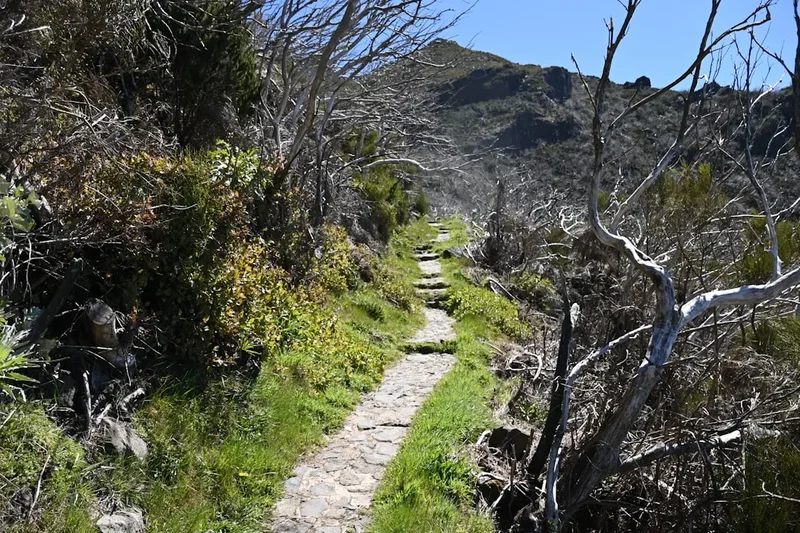
- Terrain: Stone-paved paths, steep metal staircases, and unlit volcanic tunnels
Overview
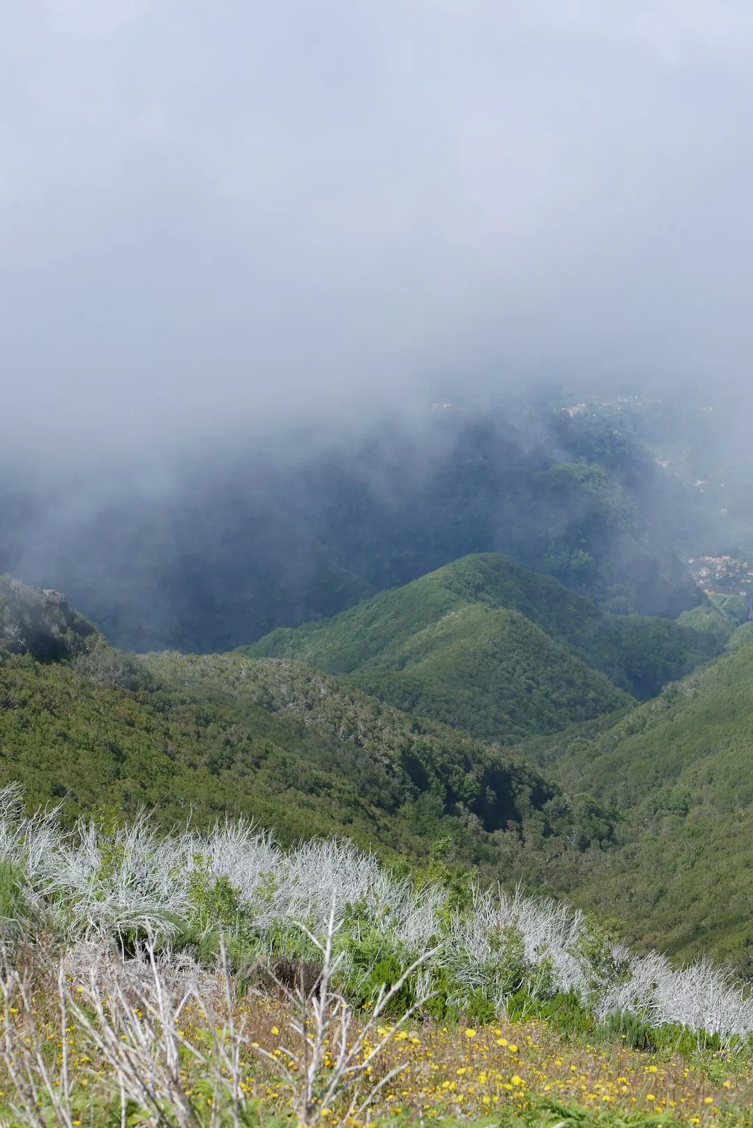
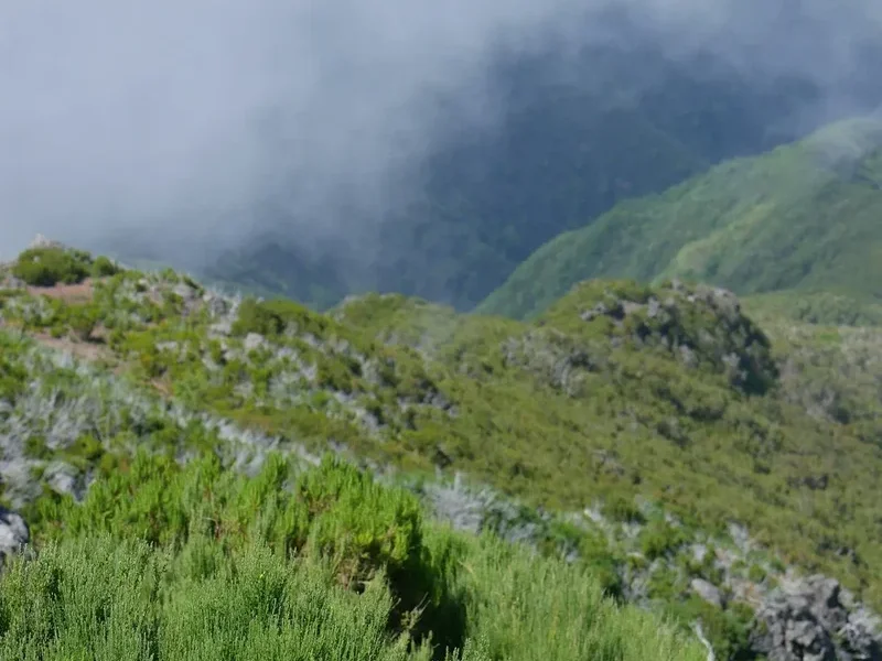
The PR1 Vereda do Arieiro is the crown jewel of Madeira’s extensive network of "Veredas" (mountain paths) and "Levadas" (aqueduct trails). Unlike the gentle gradients of the levadas, the PR1 is a rugged, high-alpine route that demands respect. The trail follows the central mountain ridge that divides the north and south coasts of the island, offering hikers a rare 360-degree perspective of Madeira’s dramatic topography. On a clear day, the views extend across the Curral das Freiras (Nun’s Valley), the massive plateau of Paúl da Serra, and even the distant island of Porto Santo. However, the true magic of the PR1 often lies in the "Mar de Nuvens" (Sea of Clouds), where the peaks emerge like islands from a white, fluffy ocean, creating an atmosphere of profound isolation and beauty.
The trail is a feat of human ingenuity. To make this vertical landscape accessible, engineers and labourers carved tunnels through solid rock and built stone staircases into near-vertical cliff faces. The most famous of these is the "Stairway to Heaven," a series of steep, narrow steps that cling to a razor-sharp ridge with precipitous drops on either side. While the path is well-maintained and protected by steel cables in exposed sections, the sheer scale of the landscape is humbling. The geology here is a vivid record of Madeira’s volcanic origins, featuring layers of reddish pyroclastic ash, dark basaltic dykes, and twisted rock formations that have been sculpted by erosion over millions of years.
Walking the PR1 is a sensory experience. You will feel the transition from the cool, damp air of the tunnels to the intense heat of the exposed ridges. You will hear the call of the endemic Madeira Firecrest and the wind whistling through the ancient, skeletal remains of heather trees. This is a journey through a UNESCO-recognised landscape, where the high-altitude flora and fauna have adapted to survive in one of the most dramatic environments on Earth. Whether you complete the full return journey or opt for a one-way trek ending at Achada do Teixeira, the PR1 leaves an indelible mark on every hiker who traverses its path.
History and Cultural Context
The history of the PR1 is inextricably linked to the development of Madeira’s forestry and communication infrastructure. For centuries, the high peaks of the island were the domain of shepherds and those seeking to cross from the north to the south. These early travellers used rudimentary, dangerous tracks to navigate the central massif. It wasn't until the mid-20th century that the Portuguese Forestry Service (now the IFCN - Institute of Forests and Nature Conservation) began formalising these routes to facilitate forest management, fire surveillance, and the protection of endemic species.
The construction of the PR1 was a monumental task. Labourers worked in extreme conditions, often at altitudes where oxygen is thinner and weather is unpredictable, to hand-carve the tunnels and pave the paths with local basalt. These paths were essential for rangers to reach the high-altitude lookouts and for the maintenance of the early meteorological stations. The trail also served a strategic purpose; during the mid-20th century, the peaks were vital for radio communications and surveillance of the surrounding Atlantic waters.
In recent decades, the PR1 has transitioned from a functional forestry route to one of the world’s most famous hiking trails. This shift reflects Madeira’s broader evolution into a premier destination for eco-tourism. Despite its popularity, the trail remains a site of significant ecological importance. The area around Pico Ruivo is one of the few remaining habitats for the Zino’s Petrel (Pterodroma madeira), Europe’s rarest seabird, which nests in the high-altitude cliffs. The cultural value of the trail lies in its demonstration of the Madeiran people's resilience and their ability to harmonise with a vertical, unforgiving landscape. Today, the trail is managed with a focus on conservation, ensuring that the influx of hikers does not compromise the fragile volcanic ecosystem or the heritage of the path itself.
Want more background? Read extended notes on history and cultural context → Learn more
Seasonal Highlights and Weather Reality
Madeira is often called the "Island of Eternal Spring," but the high peaks follow their own rules. The weather at 1,800 metres can be radically different from the coastal climate of Funchal. Understanding the seasonal nuances is critical for a safe and enjoyable trek.
Spring (March to May): This is arguably the best time to hike the PR1. The high-altitude flora, including the endemic Madeira Wallflower and various heathers, begins to bloom, adding splashes of colour to the volcanic rock. Temperatures are mild, typically ranging from 10°C to 18°C, though the wind can still be biting. This season offers a high probability of the "sea of clouds" phenomenon.
Summer (June to August): Expect clear skies and intense sun. While the coastal areas remain comfortable, the exposed ridges of the PR1 can become very hot, with temperatures reaching 25°C or higher. There is very little shade on the trail, making sun protection and hydration paramount. Early morning starts (before 8:00 AM) are essential to avoid the midday heat and the largest crowds.
Autumn (September to November): Similar to spring, autumn offers cooler temperatures and a higher chance of dramatic cloud formations. The light in October and November is particularly beautiful for photography, with softer shadows and golden hues. However, the risk of rain increases, and the stone paths can become slippery when wet.
Winter (December to February): Winter on the peaks is unpredictable. While snow is rare, it does occur, occasionally covering the trail in a thin white blanket that makes the basalt paths treacherous. High winds and heavy rain are common, often leading to temporary trail closures. Temperatures can drop to near 0°C. If you hike in winter, you must be prepared for rapid weather changes and carry full waterproof and thermal gear.
The "Microclimate" Factor: It is common to leave a sunny Funchal only to find Pico do Arieiro shrouded in thick fog or lashed by rain. Always check the live webcams (NetMadeira) and the IPMA (Portuguese Institute of the Sea and Atmosphere) mountain forecast before setting out. If the peaks are "socked in" with no visibility, the PR1 loses its primary appeal and becomes significantly more hazardous.
Recommended Itinerary
PR1 Vereda do Arieiro Route Progression
Waypoint 1: Pico do Arieiro Trailhead to Ninho da Manta
- Distance: 1.2 km
- Elevation: Minor undulations
- Time: 20–30 minutes
- Start at the radar station (the "white ball") at Pico do Arieiro
- Follow the well-paved stone path heading north
- Reach the Ninho da Manta (Buzzard’s Nest) viewpoint
- Spectacular views of the Fajã dos Cardos and the valley of Curral das Freiras
- First encounter with the dramatic vertical drops that characterise the trail
Waypoint 2: Ninho da Manta to Pedra Rija and the "Stairway to Heaven"
- Distance: 1.5 km
- Elevation: Steep descent followed by ridge walking
- Time: 30–45 minutes
- Pass through the Pedra Rija section, known for its jagged rock formations
- Traverse the "Stairway to Heaven"—narrow stone steps on a razor-thin ridge
- Steel cable handrails provide security, but vertigo-sufferers should take care
- The path begins to descend toward the tunnel section
Waypoint 3: The Tunnel Section (Pico das Torres Base)
- Distance: 2 km
- Elevation: Relatively level but requires careful footing
- Time: 45–60 minutes
- The trail splits into the "East Route" (often closed due to landslides) and the "West Route" (the standard path)
- Pass through a series of unlit tunnels carved into the base of Pico das Torres
- Tunnels vary in length; the longest requires a headlamp or torch
- The air inside is cool and damp, providing a brief respite from the sun
- Exit the tunnels to find the landscape changing to more rugged, grey volcanic rock
Waypoint 4: The Final Ascent to Pico Ruivo Shelter
- Distance: 1.5 km
- Elevation: 300 m gain
- Time: 45–60 minutes
- A series of steep, metal and stone switchbacks climb toward the summit
- Pass through the "Dead Forest"—ancient white heather trees (Erica arborea) bleached white by fire and weather
- Reach the Casa do Ruivo (Pico Ruivo Shelter), a basic stone building with toilets and a small shop (seasonal)
- This is the junction for the PR1.2 trail to Achada do Teixeira
Waypoint 5: The Summit of Pico Ruivo
- Distance: 0.5 km
- Elevation: 100 m gain
- Time: 15–20 minutes
- The final push to the highest point in Madeira (1,862 m)
- Three separate viewing platforms offer 360-degree panoramas
- On clear days, you can see the entire island from coast to coast
- Pause here to refuel before the return journey or the descent to the car park
Important Notes:
- The return journey follows the same path but feels significantly harder due to the steep climbs back up to Pico do Arieiro
- Total return time is typically 5–6 hours depending on fitness and photo stops
- If you have arranged a transfer, you will likely descend from Pico Ruivo to Achada do Teixeira (PR1.2), which is an easy 2.8 km downhill walk (approx. 45–60 mins)
- Check trail status on the IFCN website before starting; landslides frequently close sections of the path
Planning and Bookings
Book Your Trip
Everything you need to plan your journey
Accommodation
Find places to stay near Funchal
Flights
Search flights to Funchal
Essential Preparation
The PR1 is a high-mountain trail that requires more preparation than a standard coastal walk. Fitness is a key consideration; while the distance is moderate, the constant "up and down" nature of the trail, combined with the altitude, makes it physically taxing. Hikers should be comfortable with steep gradients and have no significant issues with vertigo, as many sections feature narrow paths with long drops.
Logistics are the most complex part of planning. You have three main options: 1. Self-Drive: Park at Pico do Arieiro, hike to Pico Ruivo, and hike back. This is the most physically demanding option. 2. Guided Tour: Many companies in Funchal offer guided hikes including transport. This is excellent for solo travellers or those wanting geological insights. 3. Mountain Transfers: Dedicated shuttle services (like Pico Transfers or Do It Madeira) pick you up in Funchal, drop you at Pico do Arieiro, and collect you 5–6 hours later at Achada do Teixeira. This allows you to do the hike one-way, which is the most popular choice.
Funchal is the ideal base for this hike. It is a 35–45 minute drive to the trailhead. Ensure you book your transfers at least 48 hours in advance, especially during the peak summer months.
Trail Accommodation
This is a day hike requiring no overnight accommodation on the trail itself. Camping is strictly prohibited along the PR1 and within the central mountain massif to protect the fragile ecosystem and prevent forest fires.
Casa do Ruivo (Pico Ruivo Shelter): Located just below the summit of Pico Ruivo, this is the only facility on the trail. - Facilities: Basic toilets (usually 0.50€ or 1€ fee), a small shop selling water, coffee, and snacks. - Availability: Generally open from 9:00 AM to 5:00 PM, but this is not guaranteed. - Note: There are no beds or overnight facilities here. It is a rest stop, not a hostel.
For those wishing to stay as close as possible to the trailhead, there is a small hotel (Pousada do Arieiro) located at the start of the trail at Pico do Arieiro. However, most hikers stay in Funchal or the surrounding coastal towns and travel to the peaks for the day.
Required Gear
- Hiking Boots: Sturdy boots with good grip and ankle support are essential. The stone paths can be uneven and very slippery when damp.
- Headlamp/Torch: Mandatory for the tunnels. While a phone light can work, a dedicated headlamp leaves your hands free for the cable rails.
- Layered Clothing: The temperature can fluctuate by 10°C or more between the peaks and the valleys. Bring a moisture-wicking base layer, an insulating mid-layer (fleece), and a windproof outer shell.
- Sun Protection: High-altitude sun is intense. Bring a hat, high-SPF sunscreen, and quality sunglasses.
- Backpack: A 20–30L daypack with a rain cover.
- Whistle and Basic First Aid: For emergencies, including blister plasters and antiseptic wipes.
What to Bring
- Water: Minimum 2 litres per person. There are no reliable water sources on the trail until you reach the shelter near the end.
- Food: High-energy snacks (nuts, dried fruit, chocolate) and a substantial lunch. Hiking at altitude burns more calories.
- Cash: Small change for the toilets at the Pico Ruivo shelter and for the café at Pico do Arieiro.
- Fully Charged Phone: And ideally a power bank. Cold temperatures and constant photo-taking drain batteries quickly.
- Offline Maps: Download the area on Google Maps or use a dedicated hiking app like AllTrails or Komoot, as signal can be spotty in the deep valleys.
- Tissues/Hand Sanitiser: For personal use, as facilities are limited.
Permits
As of late 2024, the Institute of Forests and Nature Conservation (IFCN) has introduced a mandatory registration and fee system for the PR1 Vereda do Arieiro to manage the high volume of hikers and fund trail maintenance.
Registration Process:
- All hikers must register via the SIMPLA platform (the official Madeira regional government portal for forest trails).
- The fee is currently 3€ per person for non-residents over the age of 12.
- Residents of Madeira remain exempt but must still register their presence on the platform.
- Registration should be done in advance, although QR codes are often available at the trailhead for last-minute bookings (provided there is mobile signal).
Enforcement:
- Rangers (Sapadores Florestais) frequently patrol the trail and may ask to see your digital or printed permit.
- Failure to produce a permit can result in a fine.
- The permit is valid for the specific day selected during registration.
Trail Closures:
- The PR1 is subject to closure during periods of extreme weather (high winds, heavy rain, or snow).
- Landslides are common, particularly on the "East Route" around Pico das Torres. Always check the "Recommended Tracks" section of the IFCN website (ifcn.madeira.gov.pt) before heading out. If a trail is marked as "Interditado" (Closed), do not attempt it; the risks from rockfall are genuine and potentially fatal.
Other Activities in the Area
Madeira’s central massif is a gateway to numerous other adventures. Consider these nearby experiences:
- Stargazing at Pico do Arieiro: With minimal light pollution and high altitude, the trailhead is one of the best spots in the Atlantic for astronomy. Several companies offer guided night tours with telescopes.
- Curral das Freiras (Nun’s Valley): After your hike, drive down into this deep volcanic crater to visit the village of the same name. Sample the local chestnut cake and ginja (cherry liqueur).
- PR1.2 Vereda do Pico Ruivo: If the PR1 is too daunting, this shorter 5.6 km return walk from Achada do Teixeira offers access to the highest peak with much less physical effort.
- Monte Palace Tropical Garden: Located in the hills above Funchal, this garden offers a lush contrast to the rugged volcanic peaks, featuring exotic plants and intricate tile work.
- Canyoning: The vertical landscape of central Madeira is world-class for canyoning. Several routes start in the mountains near the PR1, involving rappelling down waterfalls into hidden pools.
Safety and Conditions
Vertigo and Exposure: The PR1 is famous for its "balcony" sections. While the path is generally 1–2 metres wide and protected by steel cables, the drops on either side can be hundreds of metres. If you suffer from severe acrophobia, this trail will be extremely challenging. Always keep to the mountain side of the path when passing other hikers.
Tunnel Safety: The tunnels are unlit and the floors can be uneven, wet, and muddy. Low ceilings are common in certain sections—watch your head. Always use a torch and walk slowly to avoid tripping on loose rocks.
Weather Hazards: - Fog: Can descend in seconds, reducing visibility to less than 5 metres. If you lose the trail in thick fog, stay put or carefully retrace your steps to the last known marker. - Wind: The ridges are highly exposed. Gusts can be strong enough to knock a person off balance. If winds exceed 50 km/h, the trail becomes dangerous. - Heatstroke: There is almost zero shade between the tunnels and the Pico Ruivo shelter. Wear a hat and drink water even if you don't feel thirsty.
Emergency Contacts: - General Emergency: 112 - Civil Protection (Madeira): +351 291 700 112 - Ensure someone knows your planned route and expected return time. Mobile signal is generally good on the ridges but non-existent in the tunnels and some deep valleys.
Rockfall: The volcanic rock is friable and prone to erosion. Avoid hiking during or immediately after heavy rain, as this is when rockfalls and landslides are most likely to occur.
Side Trips and Points of Interest
The "Dead Forest" (Ancient Heathers): Near the final ascent to Pico Ruivo, you will walk through a haunting landscape of silver-white trees. These are ancient Erica arborea (Tree Heathers), some hundreds of years old. A major fire in 2010 killed many of them, but their skeletal remains persist, bleached by the sun and wind. They create a surreal, ghostly atmosphere, especially when the mist rolls in.
Pico das Torres: While the trail doesn't summit this peak (it is for experienced climbers only), the PR1 skirts its base. Look up at the massive basaltic dykes—vertical veins of rock that were formed when magma cooled inside cracks in the older volcanic layers. They look like giant stone ribs holding the mountain together.
Homem em Pé (Standing Man): A natural rock formation near Achada do Teixeira that resembles a standing human figure. It is a popular landmark for those finishing the one-way trek and a testament to the power of wind erosion on the island’s basalt.
Zino’s Petrel Nesting Sites: While you won't see the nests (they are hidden in inaccessible cliffs), knowing that you are walking through the only breeding ground of one of the world's rarest birds adds a layer of ecological significance to the trek. Listen for their haunting calls if you are near the peaks at dusk (though hiking at night is not recommended for most).
Leave No Trace
The central mountain massif is a protected Natura 2000 site. The high-altitude environment is extremely fragile; plants grow slowly here due to the harsh conditions, and the soil is easily eroded.
Guidelines for Responsible Hiking: - Stay on the Paved Path: Stepping off the trail crushes delicate endemic flora and accelerates soil erosion. - Carry Out All Trash: This includes organic waste like orange peels or banana skins, which decompose very slowly at high altitudes and can alter the local soil chemistry. - No Smoking or Fire: Forest fires are the greatest threat to Madeira’s biodiversity. Smoking is strongly discouraged, and any form of open flame is strictly prohibited. - Respect Wildlife: Do not feed the birds (like the friendly Madeira Chaffinch). Human food is detrimental to their health and encourages aggressive behaviour. - Toilet Etiquette: Use the facilities at Pico do Arieiro or the Pico Ruivo shelter. If you are caught short, ensure you are at least 50 metres from the trail and any water sources, and pack out your toilet paper in a sealed bag.