Trilha do Pico da Bandeira - Brazil's Highest Peak
The Trilha do Pico da Bandeira, leading to the summit of Pico da Bandeira, Brazil's third-highest mountain and the highest point in the former Brazilian states of Minas Gerais and Espírito Santo, is an iconic trekking experience. This challenging mountain track ascends through diverse ecosystems, from Atlantic Forest remnants to high-altitude grasslands, culminating in a breathtaking sunrise view from the summit at 2,891 metres. The trail is renowned for its demanding ascents, dramatic temperature fluctuations, and the unparalleled panoramic vistas offered from its peak. It is a journey that tests physical endurance and rewards with a profound connection to Brazil's natural grandeur.
- Distance: 18.0 km (round trip from Terreirão)
- Elevation Gain: 1,850 m
- Duration: 2-3 days
- Difficulty: Challenging
- Best Time: May to September (dry season)
- Huts: Terreirão Hut (basic shelter)
- Highest Point: Pico da Bandeira (2,891 m)
- Trailhead Access: Parque Nacional do Caparaó
- Direction: Out-and-back
Overview
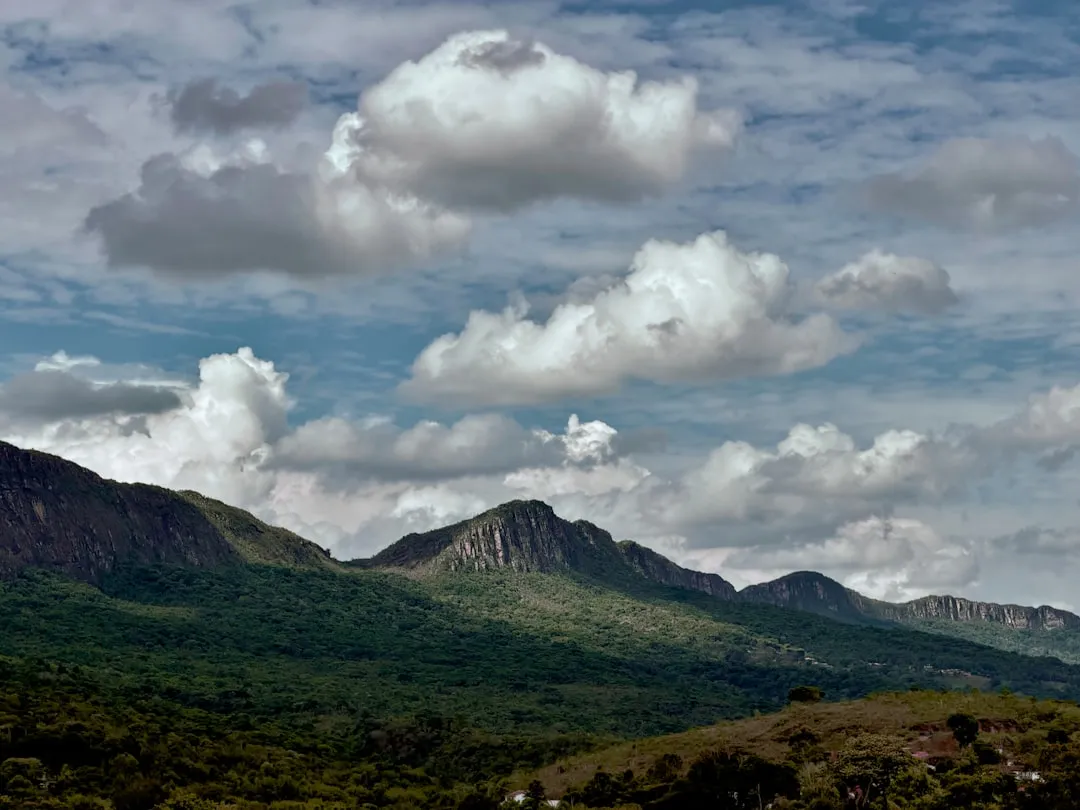
The Trilha do Pico da Bandeira is not merely a hike; it's an expedition into Brazil's high-altitude wilderness. The journey typically begins from the park's lower entrance, requiring a 4x4 vehicle or a strenuous hike to reach the Terreirão campsite, the primary staging point for the summit push. From Terreirão, the trail ascends steeply, a relentless climb that traverses varied terrain. Initially, the path winds through the remnants of the Atlantic Forest, a biome rich in biodiversity, before transitioning into the more open, windswept landscapes of the high campos rupestres (rocky fields).
The ascent is characterised by its steep gradient and the significant elevation gain. Hikers must be prepared for rapidly changing weather conditions, with temperatures plummeting dramatically as altitude increases, especially at night and in the early morning. The summit itself, often shrouded in clouds, offers a spectacular reward: a sunrise that paints the sky in vibrant hues, illuminating the vast expanse of Brazil stretching out below. On clear days, the view extends for hundreds of kilometres, encompassing rolling hills, distant mountain ranges, and a sea of clouds that can create an illusion of walking on an island in the sky.
The trail is popular, particularly during the dry season and on weekends, so booking and planning are essential. The experience is one of raw natural beauty, physical exertion, and the quiet contemplation that only high mountain environments can provide. It is a pilgrimage for many Brazilians and international adventurers seeking to conquer the nation's elevated frontiers.
History and Cultural Context
Pico da Bandeira, meaning "Flag Peak," derives its name from the Brazilian flag that was reportedly planted on its summit by Emperor Dom Pedro II in 1859. This act cemented its status as a national symbol and a significant landmark in Brazilian geography. The mountain and its surrounding national park, Parque Nacional do Caparaó, were established to protect the unique ecosystems found here, particularly the remnants of the Atlantic Forest and the high-altitude rupestrian grasslands, which are home to endemic species.
The indigenous peoples of the region, such as the Guarani and Krenak, have long held a spiritual connection to these mountains, viewing them as sacred places. Their traditional knowledge of the land, its flora, and fauna predates colonial settlement and offers a deeper understanding of the region's ecological and cultural significance.
The development of the park and the trails has been driven by a desire to preserve its natural heritage and promote ecotourism. The establishment of the Parque Nacional do Caparaó in 1961 was a crucial step in safeguarding the mountain's biodiversity and ensuring its accessibility for responsible exploration. Over the decades, the Trilha do Pico da Bandeira has become one of Brazil's most celebrated trekking routes, attracting adventurers, nature enthusiasts, and those seeking the challenge of reaching the country's highest accessible points.
Seasonal Highlights and Weather Reality
The best time to undertake the Trilha do Pico da Bandeira is during the dry season, which typically runs from May to September. This period offers the highest probability of clear skies and stable weather, crucial for a safe and enjoyable summit attempt, especially for witnessing the sunrise.
Dry Season (May to September): This is the peak season for trekking. Days are generally sunny and cool, with very little rainfall. Nights are cold, with temperatures frequently dropping below freezing, especially at higher altitudes. Frost and even light snow are possible, particularly in July and August. The clear skies provide excellent visibility for the spectacular sunrise views from the summit. However, this is also the busiest period, so booking accommodation and transport in advance is highly recommended.
Rainy Season (October to April): This period is characterised by frequent and heavy rainfall, often accompanied by thunderstorms. The trails can become muddy and slippery, increasing the risk of accidents. Visibility from the summit is often poor due to persistent cloud cover. While the Atlantic Forest is lush and vibrant during this time, the challenging weather conditions make summit attempts significantly more difficult and potentially dangerous. Some facilities within the park may also be affected by heavy rains.
Temperature Fluctuations: Regardless of the season, expect significant temperature variations. During the day, temperatures can be pleasant, but as soon as the sun sets, or at higher altitudes, the mercury can plummet rapidly. At the summit (2,891 m), temperatures can easily fall below 0°C, even in the dry season, especially during the pre-dawn hours when most hikers attempt the summit for sunrise. Proper layering is essential.
Recommended Itinerary

2-Day Itinerary: Summit Sunrise Focus
Day 1: Arrival at Parque Nacional do Caparaó and Ascent to Terreirão
- Morning: Arrive at the park entrance in Alto Caparaó. Complete registration and pay entrance fees at the ICMBio office.
- Late Morning/Early Afternoon: Arrange for a 4x4 transfer to the Terreirão campsite (approx. 8 km from the park entrance). This is a rough, unpaved road requiring a specialised vehicle. Alternatively, if you are very fit and have ample time, you can hike this section.
- Afternoon: Set up camp at Terreirão (1,850 m). This is a basic campsite with limited facilities, often including rudimentary shelters or designated camping areas.
- Late Afternoon: Short acclimatisation walk around the campsite. Prepare your gear for the summit push, including packing essentials for the night and the next morning.
- Evening: Early dinner and rest. Aim for an early bedtime to prepare for a pre-dawn start.
Day 2: Summit Push, Sunrise, and Descent
- Pre-Dawn (e.g., 1:00 AM - 2:00 AM): Wake up and begin the ascent towards Pico da Bandeira. The trail from Terreirão to the summit is approximately 9 km one-way.
- Early Morning: Hike through the rocky terrain. The path is steep and well-marked but can be challenging in the dark.
- Sunrise (approx. 5:30 AM - 6:00 AM): Arrive at the summit (2,891 m) in time to witness the spectacular sunrise. This is the highlight of the trek, offering panoramic views over a sea of clouds and distant mountains.
- Morning: After enjoying the summit and taking photographs, begin the descent back to Terreirão.
- Late Morning/Midday: Arrive back at Terreirão. Pack up your campsite.
- Afternoon: Descend from Terreirão to the park entrance, either via 4x4 transfer or by hiking.
- Late Afternoon: Depart from Parque Nacional do Caparaó.
3-Day Itinerary: More Relaxed Pace and Exploration
Day 1: Arrival and Lower Campsite
- Morning: Arrive at the park entrance in Alto Caparaó. Register and pay fees.
- Late Morning: Take a 4x4 transfer to the lower campsite, often called Tronqueira (approx. 4 km from the entrance). This campsite is more accessible and offers slightly better facilities than Terreirão.
- Afternoon: Set up camp at Tronqueira. Explore the surrounding trails and enjoy the lower-altitude forest environment.
- Evening: Dinner and rest.
Day 2: Ascent to Terreirão and Acclimatisation
- Morning: After breakfast, hike from Tronqueira to Terreirão (approx. 8 km). This section continues the ascent through varied terrain.
- Afternoon: Arrive at Terreirão. Set up camp and spend the afternoon acclimatising. You can explore the immediate vicinity or rest in preparation for the summit push.
- Evening: Early dinner and rest.
Day 3: Summit Push, Sunrise, and Descent
- Pre-Dawn (e.g., 1:00 AM - 2:00 AM): Wake up and begin the ascent from Terreirão to Pico da Bandeira (approx. 9 km).
- Early Morning: Reach the summit for sunrise.
- Morning: Descend back to Terreirão.
- Late Morning: Pack up camp at Terreirão.
- Midday: Descend from Terreirão to the park entrance, either via 4x4 or hiking.
- Afternoon: Depart from Parque Nacional do Caparaó.
Important Notes:
- The 4x4 transfer is highly recommended for reaching Terreirão, especially if time is limited.
- Book 4x4 transfers and any desired accommodation in Alto Caparaó well in advance.
- Carry sufficient water or a reliable water filter, as water sources can be scarce at higher altitudes.
- The summit push is strenuous and requires good physical condition.
- Weather can change rapidly; always be prepared for cold, wind, and rain.
- The summit area is exposed and can be very windy.
Planning and Bookings
Book Your Trip
Everything you need to plan your journey
Accommodation
Find places to stay near Alto Caparaó
Flights
Search flights to Alto Caparaó
Essential Preparation
Planning is paramount for a successful Trilha do Pico da Bandeira trek. The journey involves significant elevation gain and potentially harsh weather conditions, necessitating a good level of physical fitness. Hikers should aim for a consistent cardiovascular exercise routine in the weeks leading up to the trip, including activities like running, cycling, or stair climbing. Familiarity with hiking on uneven and steep terrain is also beneficial.
The closest town to the Parque Nacional do Caparaó is Alto Caparaó, located in the state of Minas Gerais. This town serves as the primary gateway for accessing the park. Accommodation options in Alto Caparaó range from simple guesthouses (pousadas) to more comfortable hotels. It is advisable to book accommodation in Alto Caparaó in advance, especially during peak season (May to September) and on weekends. The town also offers essential services such as restaurants, small shops for last-minute supplies, and local guides or 4x4 transfer services.
Logistics for reaching the trailhead involve flying into a major airport like Vitória (VIX) in Espírito Santo or Belo Horizonte (CNF) in Minas Gerais. From these cities, one can take a bus to a regional town and then a local bus or taxi to Alto Caparaó. The final leg to the park entrance and then to the Terreirão campsite typically requires a pre-arranged 4x4 vehicle due to the challenging road conditions.
Trail Accommodation
The primary accommodation options within the Parque Nacional do Caparaó for trekkers aiming for Pico da Bandeira are basic campsites. The most common staging points are:
Tronqueira Campsite:
- Location: Approximately 4 km from the park entrance.
- Facilities: Basic camping areas, some rudimentary shelters, and potentially a simple communal area. Water sources are usually available, but treatment is recommended. Toilets are typically basic pit latrines.
- Booking Requirements: While not always strictly enforced for campsites, it is advisable to check with ICMBio (Instituto Chico Mendes de Conservação da Natureza) for any registration requirements, especially during peak season.
- Seasonal Availability: Generally open year-round, but access can be affected by heavy rains during the wet season.
- Costs: Nominal camping fees may apply, payable at the park entrance or ICMBio office.
Terreirão Campsite:
- Location: Approximately 8 km from the park entrance, at a higher altitude (1,850 m). This is the main base for the summit push.
- Facilities: Similar to Tronqueira, offering basic camping spots and potentially some shelters. Water sources are available but should be treated. Basic toilet facilities are usually present.
- Booking Requirements: Registration with ICMBio is recommended.
- Seasonal Availability: Open year-round, but access is highly dependent on weather conditions, especially the road leading to it.
- Costs: Nominal camping fees may apply.
What's NOT Provided:
- No sleeping bags, mattresses, or bedding are provided.
- No cooking equipment, stoves, or fuel are provided.
- No electricity or charging facilities are available at the campsites.
- No food or water supplies are available on the trail or at campsites.
- No organised guiding services are provided by the park; independent hikers must be self-sufficient.
Note: This is a day hike requiring no overnight accommodation if attempting from the park entrance to the summit and back in a single, extremely long day, which is not recommended due to the distance, elevation, and safety considerations. The standard approach involves overnight stays at the designated campsites.
Required Gear
- Sturdy hiking boots: Waterproof and well broken-in, with good ankle support for steep and rocky terrain.
- Backpack: A 40-60 litre capacity backpack is suitable for carrying essentials for a 2-3 day trek. Ensure it has a comfortable harness and hip belt.
- Waterproof and windproof jacket: Essential for protection against rain and strong winds, especially at higher altitudes.
- Waterproof overtrousers: To keep legs dry during rain.
- Warm layers: Multiple layers of synthetic or wool clothing (base layer, mid-layer fleece or down jacket).
- Hat: A warm beanie for cold temperatures and a sun hat for daytime protection.
- Gloves: Warm gloves are essential for the cold summit conditions.
- Head torch: With spare batteries, crucial for the pre-dawn summit ascent.
- First-aid kit: Including personal medications, blister treatment, pain relievers, antiseptic wipes, and bandages.
- Navigation tools: Map of the park, compass, and/or a GPS device or smartphone with offline maps. While the trail is generally well-marked, it's vital to have backups.
- Sun protection: High SPF sunscreen, sunglasses, and lip balm.
- Trekking poles: Highly recommended for stability on steep ascents and descents, and to reduce strain on knees.
What to Bring
- Food: Sufficient non-perishable food for 2-3 days, including high-energy snacks, meals, and breakfast items. Consider freeze-dried meals for ease of preparation.
- Water bottles or hydration reservoir: Capacity for at least 2-3 litres per person.
- Water treatment: Water filter or purification tablets, as water sources should be treated before consumption.
- Cooking stove and fuel: A lightweight camping stove and sufficient fuel for boiling water and cooking meals.
- Cookware and utensils: Pot, mug, bowl, spoon/fork.
- Toiletries: Biodegradable soap, toothbrush, toothpaste, toilet paper, hand sanitiser.
- Sleeping bag: Rated for cold temperatures (0°C or lower comfort rating is advisable).
- Sleeping mat: For insulation and comfort at the campsite.
- Trash bags: To pack out all waste.
- Camera: To capture the stunning scenery.
- Personal identification and park entrance fee payment.
- Cash: For local transport, food in Alto Caparaó, and potential park fees.
Permits

Access to the Parque Nacional do Caparaó requires registration and payment of entrance fees. This is typically managed by ICMBio (Instituto Chico Mendes de Conservação da Natureza), the Brazilian federal agency responsible for protected areas.
Registration and Fees:
- Park Entrance Fee: A daily fee is charged for entry into the national park. The exact amount can vary, so it's advisable to check the official ICMBio website or contact the park administration for the most current rates.
- Campsite Fees: There may be separate, nominal fees for using the designated campsites (Tronqueira and Terreirão).
- 4x4 Transfer Fees: If you opt for a 4x4 transfer to the higher campsites, these services are provided by local operators and have their own separate charges.
Booking and Registration Process:
- In Person: The most common method is to register and pay fees directly at the ICMBio office located at the park entrance in Alto Caparaó. It is recommended to arrive early in the day, especially during peak season, as there can be queues.
- Online (Potential): While not always available or consistently updated, ICMBio sometimes offers online booking and payment options for national parks. It is worth checking the official ICMBio website for Parque Nacional do Caparaó for any online registration portals.
- Advance Notice: For peak periods, it is wise to contact the park administration in advance to inquire about registration procedures and to ensure availability, particularly for the 4x4 transfers.
Important Considerations:
- Peak Season: During holidays, long weekends, and the dry season (May-September), the park can become very busy. Arriving early in the day for registration is crucial.
- 4x4 Vehicle: The road to Terreirão is extremely rough and requires a 4x4 vehicle. If you do not have one, you must arrange a transfer with a local operator in Alto Caparaó. These transfers are often booked in advance.
- Guides: While the main trail to Pico da Bandeira is generally well-marked, hiring a local guide is recommended, especially if you are unfamiliar with the area, the weather conditions, or if you plan to explore less-travelled routes. Guides can also assist with logistics and provide valuable insights into the local flora and fauna.
Other Activities in the Area
Beyond the iconic trek to Pico da Bandeira, the Parque Nacional do Caparaó and its surroundings offer several other attractions and activities for visitors:
- Hiking to Cachoeira da Farofa: A beautiful waterfall located within the park, accessible via a moderate hike from the lower areas. It's a great spot for a refreshing dip and to enjoy the lush Atlantic Forest scenery.
- Exploring the Atlantic Forest Trails: The park is a sanctuary for the Atlantic Forest biome, one of the most biodiverse and threatened ecosystems on Earth. Various trails allow visitors to immerse themselves in this rich environment, observing diverse plant life, bird species, and potentially other wildlife.
- Visiting the Cachoeira do Aurélio: Another picturesque waterfall within the park, offering a different perspective on the region's natural beauty.
- Birdwatching: The park is a haven for numerous bird species, including many endemic to the Atlantic Forest. Birdwatchers can spot toucans, hummingbirds, tanagers, and various other colourful avian life.
- Photography: The dramatic landscapes, unique flora, and stunning sunrises and sunsets provide ample opportunities for photographers.
- Cultural Immersion in Alto Caparaó: The town of Alto Caparaó itself offers a glimpse into local life. Visitors can enjoy regional cuisine, interact with the friendly locals, and learn more about the history and culture of the Caparaó region.
- Visiting other peaks: While Pico da Bandeira is the highest, the park contains other notable peaks and viewpoints that can be explored by experienced hikers.
Safety and Conditions
Weather Preparedness: The most significant safety concern on the Trilha do Pico da Bandeira is the unpredictable mountain weather. Temperatures can drop drastically, especially at night and near the summit. Hypothermia is a real risk. Always carry adequate warm clothing, including waterproof and windproof outer layers, a hat, and gloves. Be prepared for rain, fog, and strong winds, even during the dry season.
Altitude Sickness: While not as high as some world-famous peaks, the altitude of 2,891 metres can affect some individuals. Ascending gradually and spending time acclimatising at the campsites (Tronqueira and Terreirão) can help mitigate the effects of altitude sickness. Symptoms include headache, nausea, dizziness, and fatigue. If symptoms are severe, descend immediately.
Trail Conditions: The trail from Terreirão to the summit is steep, rocky, and can be slippery, particularly after rain or if there is frost. Wear sturdy hiking boots with good grip. Trekking poles are highly recommended to aid stability and reduce strain on your joints.
Navigation: While the main trail to Pico da Bandeira is generally well-marked, visibility can be severely reduced by fog. Carry a map, compass, and/or GPS device, and know how to use them. Inform someone of your hiking plans, including your expected return time.
Water and Food: Ensure you carry sufficient water and high-energy food. Water sources at higher altitudes may be scarce or unreliable, and water should always be treated before consumption. Dehydration can exacerbate altitude sickness symptoms.
Emergency Services: In case of an emergency, contact the park rangers or local authorities. Mobile phone reception can be unreliable within the park, especially at higher elevations. Consider carrying a personal locator beacon (PLB) for remote areas.
Respect Wildlife: While large dangerous animals are not a primary concern, be aware of smaller wildlife and insects. Avoid feeding any animals, as this can disrupt their natural behaviour and health.
4x4 Road Safety: The road to Terreirão is extremely rough and requires experienced drivers and suitable vehicles. If you are not comfortable driving in such conditions, hire a local 4x4 service.
Side Trips and Points of Interest
Pico do Cristal: Located within the same national park, Pico do Cristal is another significant peak, often considered a more challenging but equally rewarding climb. It offers spectacular views and a different perspective on the Caparaó massif. Access and trails are distinct from Pico da Bandeira.
Cachoeira da Fumaça (Smoke Waterfall): While not directly on the Pico da Bandeira trail, this impressive waterfall is a notable feature within the broader Caparaó region and can be a destination for those seeking further exploration.
The "Pedra do Sino" (Bell Rock): A distinctive rock formation that can be seen from various points within the park, offering a unique geological landmark.
The Atlantic Forest Ecosystem: The entire park is a point of interest for its rich biodiversity. The lower-altitude trails offer opportunities to observe a vast array of plant species, including bromeliads, orchids, and ancient trees, as well as a diverse bird population. Keep an eye out for endemic species that are unique to this biome.
The Sunrise from the Summit: This is the primary "point of interest" and the culmination of the trek. The experience of watching the sun rise above a sea of clouds from Brazil's third-highest peak is unforgettable. The colours and the vastness of the landscape are truly awe-inspiring.
Leave No Trace
The Parque Nacional do Caparaó is a precious natural resource, and adhering to Leave No Trace principles is crucial for preserving its beauty and ecological integrity for future visitors and generations. As a hiker on the Trilha do Pico da Bandeira, your actions directly impact the environment.
Plan Ahead and Prepare: Understand the regulations of the park, check weather forecasts, and be prepared for the conditions. This includes carrying appropriate gear and sufficient supplies.
Travel and Camp on Durable Surfaces: Stick to marked trails to avoid damaging fragile vegetation. Camp only in designated campsites (Tronqueira and Terreirão) and avoid creating new sites. Ensure your campsite is left as you found it.
Dispose of Waste Properly: Pack out everything you pack in. This includes all food scraps, wrappers, and any other litter. Use designated toilet facilities where available, or dig catholes at least 60 metres away from water sources, trails, and campsites. Pack out all toilet paper.
Leave What You Find: Do not remove any natural objects, such as rocks, plants, or flowers. Respect the natural environment and leave it for others to enjoy.
Minimise Campfire Impacts: Campfires are generally discouraged or prohibited in national parks due to the risk of wildfires and damage to the environment. Use a portable stove for cooking instead.
Respect Wildlife: Observe wildlife from a distance and never feed animals. Feeding wildlife can disrupt their natural behaviours, diets, and health.
Be Considerate of Other Visitors: Keep noise levels down, especially at campsites and during early morning or late evening hours. Yield to other hikers on the trail.