The Pennine Way: Britain's Oldest National Trail
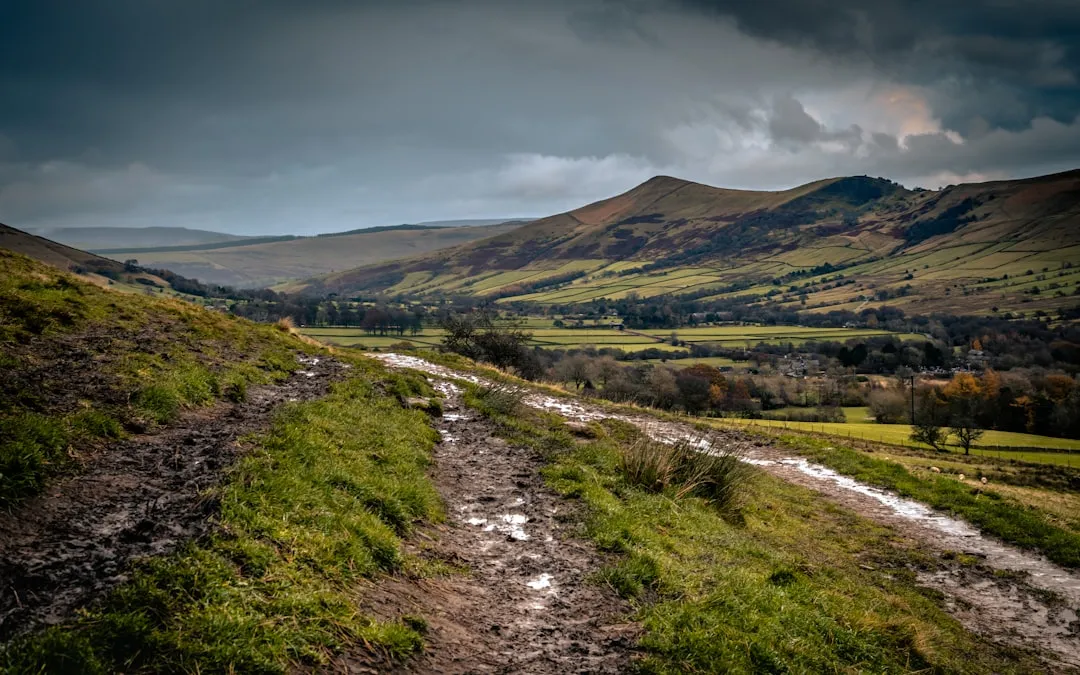
Stretching for 431 kilometres from the Peak District National Park to the Scottish Borders, the Pennine Way is a legendary long-distance footpath that traverses some of England's most dramatic and remote landscapes. Often referred to as "the backbone of England," this iconic trail winds its way through three National Parks: the Peak District, the Yorkshire Dales, and Northumberland. It is a journey of immense variety, from the rolling moorlands and gritstone edges of the Peak District, through the limestone dales and rugged fells of Yorkshire, to the wild, windswept beauty of the North Pennines and the Cheviot Hills.
- Distance: 431 km one-way
- Duration: 16–20 days
- Season: April–October (best weather, though can be unpredictable)
- Difficulty: Very Challenging
- Highest point: Cross Fell (893 m)
- Terrain: Varied – moorland, bog, farmland, rocky paths, some road sections
- Start: Edale, Peak District
- End: Kirk Yetholm, Scottish Borders
Overview
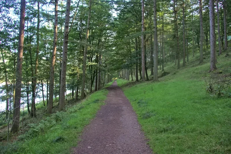
The Pennine Way is not for the faint-hearted. It is a true test of endurance, navigation, and mental fortitude, demanding respect for the wild and often unforgiving terrain it crosses. The trail's character shifts dramatically as you progress northwards. Initially, in the Peak District, you'll encounter the distinctive gritstone edges and heather-clad moors, offering expansive views and a sense of wildness close to major urban centres. As you enter the Yorkshire Dales, the landscape transforms into a mosaic of limestone pavements, drystone walls, and verdant valleys dotted with charming villages. This section is often considered the most picturesque, with iconic landmarks like Malham Cove and Ribblehead Viaduct.
Further north, the trail enters the North Pennines, a vast Area of Outstanding Natural Beauty characterised by its remote moorlands, peat bogs, and dramatic geological features. This is arguably the most challenging and remote section, where navigation can be difficult, especially in poor visibility. The landscape here is stark and beautiful, with a profound sense of solitude. Finally, the Pennine Way crosses into Northumberland, traversing the rolling hills of the Cheviot range before descending towards the Scottish border. Throughout the journey, you'll encounter a rich tapestry of history, from ancient Roman roads and Hadrian's Wall to the remnants of industrial heritage and the stories of rural life.
The Pennine Way is a journey of self-discovery, pushing personal limits and offering unparalleled rewards. It is a chance to disconnect from the modern world and immerse yourself in the raw beauty of the British countryside. While challenging, the sense of accomplishment upon reaching Kirk Yetholm is immense, marking the completion of one of Britain's most celebrated walking adventures.
History and Cultural Context
The Pennine Way was officially opened on 24 April 1965, making it Britain's first recognised long-distance footpath. Its creation was the culmination of years of campaigning by outdoor enthusiasts and ramblers who recognised the potential of linking existing footpaths and bridleways across the Pennine range to create a continuous route from the Peak District to Scotland. The vision was to provide a challenging and scenic walk that showcased the diverse landscapes and natural beauty of England's "backbone."
The route largely follows ancient tracks and drovers' roads that have been used for centuries. For millennia, these upland routes served as vital arteries for trade, communication, and migration. The Romans, for instance, established a network of roads across the Pennines, including sections that are still part of the modern trail, such as Dere Street. Later, drovers used these paths to move livestock between markets, and during the industrial revolution, they became routes for transporting goods and raw materials.
The establishment of the Pennine Way was a significant step in the development of public access to the countryside in the UK. It was a response to the growing demand for recreational walking and a desire to protect and promote the natural heritage of the uplands. The trail's route was carefully chosen to pass through areas of outstanding natural beauty, historical significance, and ecological importance, including three National Parks: the Peak District, Yorkshire Dales, and Northumberland.
Over the decades, the Pennine Way has become a rite of passage for many walkers, attracting both British and international hikers. It has inspired countless personal challenges, adventures, and a deep appreciation for the wild landscapes of northern England. The trail's history is intertwined with the broader story of the rambler movement and the ongoing effort to preserve access to and enjoyment of the British countryside.
Seasonal Highlights and Weather Reality
The Pennine Way is a year-round trail, but the optimal time for walking is generally between April and October. During these months, daylight hours are longer, and the weather is typically milder, although still highly unpredictable.
Spring (April–May): This is a beautiful time to start the walk. The landscape begins to awaken, with wildflowers appearing in the dales and moorlands showing signs of new growth. However, spring can bring a mix of weather, from crisp, sunny days to cold winds and even late snowfalls, particularly at higher elevations like Cross Fell. Lambing season means some farmland paths may have temporary diversions.
Summer (June–August): The longest days offer the most flexibility for hiking. The moors are often at their most vibrant, and the dales are lush and green. However, summer can also bring heavy rainfall, thunderstorms, and persistent cloud cover, especially in the uplands. Midges and other biting insects can be a nuisance, particularly in damp, sheltered areas. This is also the busiest time for walkers.
Autumn (September–October): This season offers stunning colours as the heather turns purple and the deciduous trees in the valleys change hue. The air is often crisp and clear, and the crowds begin to thin. However, days are shorter, and the weather can become increasingly challenging, with colder temperatures, stronger winds, and a higher chance of rain and fog. Early snow is possible on the higher sections.
Winter (November–March): Walking the Pennine Way in winter is an extreme challenge, suitable only for experienced winter mountaineers with appropriate navigation skills, equipment, and knowledge of avalanche risks. Snow and ice can make sections impassable, daylight is limited, and temperatures can be well below freezing. Huts and accommodation may be closed or have reduced services. This season is generally not recommended for casual long-distance hikers.
Weather is the single most significant factor influencing the Pennine Way experience. It is crucial to be prepared for all conditions, regardless of the season. Expect wind, rain, and fog at any time of year, especially on the exposed moorland sections.
Recommended Itinerary
18-Day Pennine Way Itinerary (Example)
This is a suggested itinerary; many walkers take longer (up to 20 days) or shorter (14-16 days) depending on their pace and preferences.
Day 1: Edale to Crowden
- Distance: 15 km
- Elevation gain: 400 m
- Time: 4–5 hours
- Start at the Pennine Way marker in Edale village
- Ascend Jacob's Ladder and ascend onto Kinder Scout plateau
- Navigate across the exposed Kinder plateau
- Descend to Crowden Youth Hostel
Day 2: Crowden to Standedge
- Distance: 18 km
- Elevation gain: 350 m
- Time: 5–6 hours
- Follow the Pennine Way along the Pennine watershed
- Pass through moorland and across reservoirs
- Cross the Standedge Tunnels, a major engineering feat
- Overnight near Standedge
Day 3: Standedge to Ripponden
- Distance: 22 km
- Elevation gain: 400 m
- Time: 6–7 hours
- Continue through moorland and farmland
- Descend into the Calder Valley
- Pass through small villages and towns
- Reach Ripponden for accommodation
Day 4: Ripponden to Fountain's Fell
- Distance: 25 km
- Elevation gain: 500 m
- Time: 7–8 hours
- Climb out of the valley onto more open moorland
- Pass through areas of peat bog
- Aim for accommodation near Fountain's Fell
Day 5: Fountain's Fell to Malham
- Distance: 18 km
- Elevation gain: 300 m
- Time: 5–6 hours
- Descend towards the Yorkshire Dales
- Pass through agricultural land and limestone scenery
- Arrive in the popular village of Malham
Day 6: Malham to Ribblehead
- Distance: 25 km
- Elevation gain: 450 m
- Time: 7–8 hours
- Walk past Malham Cove and Gordale Scar
- Cross more limestone pavements and moorland
- Reach the iconic Ribblehead Viaduct
- Overnight near Ribblehead
Day 7: Ribblehead to Hawes
- Distance: 15 km
- Elevation gain: 250 m
- Time: 4–5 hours
- Continue through the heart of the Yorkshire Dales
- Pass through Whernside, the highest point in Yorkshire
- Descend into the market town of Hawes
Day 8: Hawes to Tan Hill
- Distance: 18 km
- Elevation gain: 400 m
- Time: 5–6 hours
- Leave Hawes and climb onto higher moorland
- Pass the Tan Hill Inn, the highest pub in Britain
- Overnight near Tan Hill
Day 9: Tan Hill to Bowes
- Distance: 20 km
- Elevation gain: 350 m
- Time: 6–7 hours
- Cross more remote moorland
- Pass through the village of Bowes
- Accommodation in or near Bowes
Day 10: Bowes to Middleton-in-Teesdale
- Distance: 25 km
- Elevation gain: 400 m
- Time: 7–8 hours
- Follow the River Tees upstream
- Pass High Force, one of England's most spectacular waterfalls
- Arrive in Middleton-in-Teesdale
Day 11: Middleton-in-Teesdale to Cow Green Reservoir
- Distance: 18 km
- Elevation gain: 300 m
- Time: 5–6 hours
- Continue along the Teesdale valley
- Cross moorland towards Cow Green Reservoir
- Overnight near the reservoir
Day 12: Cow Green Reservoir to Alston
- Distance: 25 km
- Elevation gain: 500 m
- Time: 7–8 hours
- Enter the North Pennines Area of Outstanding Natural Beauty
- Cross the exposed Cross Fell, the highest point on the Pennine Way (893 m)
- Navigate potentially challenging terrain in poor visibility
- Descend to the historic lead mining town of Alston
Day 13: Alston to Greenhead
- Distance: 22 km
- Elevation gain: 350 m
- Time: 6–7 hours
- Continue through the North Pennines
- Pass through more remote moorland and former mining areas
- Reach Greenhead, near Hadrian's Wall
Day 14: Greenhead to Byrness
- Distance: 25 km
- Elevation gain: 450 m
- Time: 7–8 hours
- Follow sections of Hadrian's Wall
- Cross the border into Northumberland National Park
- Enter the wild and remote Cheviot Hills
- Overnight in Byrness
Day 15: Byrness to Carter Bar
- Distance: 18 km
- Elevation gain: 400 m
- Time: 5–6 hours
- Continue through the Cheviot Hills
- Reach Carter Bar, the border crossing point
- Accommodation options are limited in this remote area
Day 16: Carter Bar to Kirk Yetholm
- Distance: 15 km
- Elevation gain: 300 m
- Time: 4–5 hours
- Final push towards the Scottish border
- Descend into the village of Kirk Yetholm
- Celebrate completion of the Pennine Way
Important Notes:
- This itinerary is a guideline; adjust based on your fitness and preferred pace.
- Accommodation needs to be booked well in advance, especially in popular villages.
- Consider using a baggage transfer service to lighten your load.
- Be prepared for variable weather and challenging navigation, particularly on the moorland sections.
- Mobile phone signal is often unreliable.
Planning and Bookings
Book Your Trip
Everything you need to plan your journey
Accommodation
Find places to stay near Edale
Flights
Search flights to Edale
Essential Preparation
The Pennine Way is a significant undertaking requiring thorough planning. Before you even set foot on the trail, consider your fitness levels. This is a demanding walk with considerable elevation gain and long days. Train by undertaking long hikes with a loaded pack, ideally on varied terrain. Familiarise yourself with map reading and navigation skills, as the trail can be poorly marked and visibility can drop rapidly on the moors.
Logistics are key. Decide whether you will carry all your gear or use a baggage transfer service. Baggage transfer services are highly recommended for most walkers, as they allow you to travel lighter and enjoy the scenery more. Research and book accommodation well in advance, especially during peak season (summer) and in popular villages like Malham and Hawes. Many sections of the trail pass through remote areas with limited accommodation options, so planning ahead is crucial.
The closest major city to the southern trailhead in Edale is Manchester. Manchester Airport (MAN) is a well-connected international hub. From Manchester Piccadilly station, you can take a direct train to Edale (approx. 1 hour). Alternatively, you can travel by train to Sheffield and then take a bus to Edale. For those driving, parking is available in Edale, but it can be limited, especially during busy periods. The northern end at Kirk Yetholm is more remote. The nearest major towns with good transport links are Kelso and Berwick-upon-Tweed, from where you can arrange onward transport.
Trail Accommodation
Accommodation along the Pennine Way varies significantly, from traditional pubs with rooms and B&Bs to dedicated hostels and campsites. Booking in advance is essential, particularly during the peak walking season (June-August) and in popular locations.
Types of Accommodation:
- Youth Hostels (YHA): Several YHA hostels are located along or near the route (e.g., Crowden, Hawes, Alston). They offer dormitory-style beds and often private rooms, with shared kitchen and bathroom facilities. Booking is essential.
- B&Bs and Guesthouses: Found in most villages and towns along the route, offering comfortable private rooms with breakfast.
- Inns and Pubs: Many villages have traditional pubs that offer rooms. This is a popular option for walkers, providing a warm atmosphere and hearty meals.
- Hotels: Available in larger towns like Hawes and Alston, offering a higher level of comfort and service.
- Campsites: Designated campsites are available in some locations, offering a more budget-friendly option. Wild camping is generally discouraged and often illegal on enclosed farmland and in National Parks without explicit permission, though it may be tolerated in very remote upland areas if done responsibly and discreetly. Always check local regulations.
- Bunkhouses: Basic shared accommodation, often found in more remote areas.
What's Provided: Typically includes a bed, access to bathrooms, and often breakfast. Some hostels and bunkhouses have self-catering kitchens.
What's NOT Provided: Sleeping bags are usually required for hostels and bunkhouses. Towels may or may not be provided. Food is generally not included unless specified (e.g., breakfast at B&Bs).
Seasonal Availability: Most accommodation operates year-round, but some smaller establishments may close during the winter months (November-March). Booking is always recommended, even outside peak season.
Costs: Prices vary widely. Hostels can range from £25-£40 per night for a dorm bed. B&Bs and guesthouses typically cost £60-£100 per night for a double room. Hotels will be more expensive.
Required Gear
- Waterproof Jacket: A high-quality, breathable, waterproof jacket with taped seams is essential.
- Waterproof Overtrousers: Full-length zips are recommended for ease of use.
- Walking Boots: Sturdy, waterproof, ankle-supporting walking boots that are well broken-in.
- Socks: Several pairs of moisture-wicking walking socks (wool or synthetic).
- Backpack: A comfortable backpack of 45-65 litres, with a good hip belt and rain cover.
- Sleeping Bag: A 3-season sleeping bag is recommended for hostels and bunkhouses.
- Head Torch: With spare batteries, essential for early starts, late finishes, and navigating accommodation in the dark.
- Navigation Tools: Ordnance Survey (OS) Explorer maps (1:25,000 scale) for the entire route, a compass, and a GPS device or smartphone with offline mapping app. Knowledge of how to use them is vital.
- First-Aid Kit: Including blister plasters, pain relievers, antiseptic wipes, bandages, and any personal medication.
- Sun Protection: Sunscreen, sunglasses, and a sun hat, even on cloudy days.
- Insect Repellent: Especially for the summer months to ward off midges and other biting insects.
- Whistle: For emergency signalling.
What to Bring
- Food: Pack high-energy snacks (nuts, dried fruit, energy bars) for daily walking. Plan your meals for days when accommodation might not have catering facilities.
- Water Bottles/Bladder: Carry at least 2 litres of water. Water sources are available but should be treated (filter or purification tablets) if not from a reliable tap.
- Water Treatment: A water filter or purification tablets are recommended for natural water sources.
- Toiletries: Biodegradable soap, toothbrush, toothpaste, small towel, hand sanitiser.
- Clothing Layers:
- Base layers (merino wool or synthetic)
- Mid-layers (fleece or insulated jacket)
- Warm hat and gloves
- Walking trousers (quick-drying, not jeans)
- Spare set of dry clothes for evenings
- Trekking Poles: Highly recommended for stability, especially on descents and rough terrain.
- Duct Tape: For emergency repairs to gear.
- Small Knife or Multi-tool: Useful for various tasks.
- Book or Journal: For downtime in the evenings.
- Cash: Some smaller establishments may not accept cards.
Permits
The Pennine Way does not require specific permits for walking. As a designated National Trail, it is open to the public. However, access to certain sections may be subject to temporary restrictions due to farming activities (e.g., lambing season) or conservation efforts. Always check local signage and be aware of any diversions.
National Park Access: The trail passes through three National Parks: Peak District, Yorkshire Dales, and Northumberland. While no permits are needed for walking, it is important to respect the rules and guidelines of these parks, which aim to protect the natural environment and ensure responsible access.
Accommodation Bookings: The primary "booking" requirement is for accommodation. As mentioned in the planning section, it is crucial to book your overnight stays well in advance, especially during the peak season (June-August) and in popular villages. This applies to hostels, B&Bs, inns, and campsites.
Baggage Transfer Services: If you opt for a baggage transfer service, you will need to book this with a reputable company. These services typically operate between designated points along the trail, collecting your luggage from one accommodation and delivering it to the next.
Wild Camping: While not strictly prohibited everywhere, wild camping on the Pennine Way is generally discouraged and often illegal on enclosed farmland and within National Parks without landowner permission. Responsible wild camping, where permitted and done discreetly, involves leaving no trace and respecting the environment. Always research local policies and be prepared to use designated campsites or commercial accommodation.
Other Activities in the Area
The Pennine Way offers numerous opportunities to explore the surrounding areas and engage in other activities:
- Hadrian's Wall: A significant portion of the Pennine Way runs alongside or in close proximity to this UNESCO World Heritage Site, a testament to Roman engineering and history. You can easily incorporate visits to forts like Housesteads and Vindolanda.
- Malham Cove and Gordale Scar: These spectacular limestone formations in the Yorkshire Dales are easily accessible from the trail and offer breathtaking scenery and geological interest.
- Ribblehead Viaduct: A magnificent Victorian railway viaduct in the Yorkshire Dales, offering impressive photographic opportunities and a sense of industrial heritage.
- High Force Waterfall: One of England's most impressive waterfalls, located in Teesdale, a short detour from the main trail.
- The Lake District National Park: While not directly on the Pennine Way, the Lake District is relatively accessible from sections in the Yorkshire Dales and offers world-class hiking, climbing, and watersports.
- Yorkshire Dales National Park: Explore charming villages, historic abbeys (like Fountains Abbey, a detour from the route), and enjoy local produce and crafts.
- Northumberland National Park: Discover the wild beauty of the Cheviot Hills, Kielder Forest, and the vast, dark skies perfect for stargazing.
- Roman forts and museums: Along the route, particularly near Hadrian's Wall, numerous Roman sites offer insights into the region's past.
- Local pubs and breweries: Experience traditional British hospitality, sample local ales, and enjoy hearty meals in the many pubs along the trail.
Safety and Conditions
Weather: The most significant safety concern on the Pennine Way is the unpredictable and often severe weather. Moorland sections are exposed, and conditions can change rapidly. Be prepared for strong winds, heavy rain, fog, and even snow at higher elevations, regardless of the season. Always check the mountain weather forecast (e.g., Met Office Mountain Forecast) before setting out each day and be prepared to alter your plans if conditions are dangerous.
Navigation: While the Pennine Way is waymarked, some sections, particularly across the Kinder Scout plateau, the Yorkshire Dales moors, and the North Pennines, can be poorly marked or indistinguishable in poor visibility. Carry and know how to use a map and compass. A GPS device or smartphone with offline maps is a valuable backup, but do not rely on electronics alone.
Terrain: The trail includes a variety of terrain, from well-maintained paths and farmland tracks to boggy moorland and rocky ascents. Be aware of uneven ground, slippery surfaces (especially when wet), and potential hazards like peat bogs, which can be deep and treacherous. Wear appropriate footwear with good ankle support.
Remoteness: Many sections of the Pennine Way are remote, with limited access for emergency services. Mobile phone reception can be patchy or non-existent. Inform someone of your itinerary and expected arrival times. Consider carrying a personal locator beacon (PLB) or satellite messenger for emergencies in very remote areas.
Water: While water is generally plentiful, it should be treated before drinking if sourced from natural streams or reservoirs, as it may be contaminated. Carry sufficient water for each day's walk, especially on longer, more remote sections.
Farming: You will be crossing farmland. Always close gates behind you, keep dogs under control, and be mindful of livestock. Avoid disturbing sheep and lambs, especially during lambing season.
Emergency Procedures: In case of an emergency, dial 999 or 112 and ask for Police, then Mountain Rescue. Provide your location as accurately as possible.
Side Trips and Points of Interest
Kinder Scout Plateau: The highest and most dramatic section of the Peak District. While the main trail crosses it, dedicated exploration can reveal stunning gritstone formations, waterfalls, and a true sense of wildness. Navigation here is critical.
Malham Cove and Gordale Scar: A short detour from the main trail in the Yorkshire Dales leads to these magnificent limestone geological features. Malham Cove is a vast, curved cliff face with a unique limestone pavement at its top, while Gordale Scar is a dramatic gorge with waterfalls.
Ribblehead Viaduct: This iconic Victorian railway viaduct is a striking landmark in the Yorkshire Dales. Walking beneath its arches or viewing it from a distance is a memorable experience.
Whernside: The highest of the Yorkshire Dales' "Three Peaks" (838 m), which the Pennine Way crosses. The views from the summit on a clear day are extensive.
Tan Hill Inn: Located at 528 metres above sea level, this is the highest licensed pub in Great Britain. It's a historic and atmospheric stop for a well-earned rest and refreshment.
High Force Waterfall: A spectacular waterfall on the River Tees in Teesdale, one of the most impressive in England. It's a worthwhile detour from the main trail.
Hadrian's Wall: The Pennine Way runs alongside sections of this ancient Roman frontier. Detours to explore forts like Housesteads, Vindolanda, and Chesters Roman Fort offer a deep dive into history.
The Cheviot Hills: The final upland section offers a wild and remote landscape, with opportunities for exploring the rugged terrain and enjoying panoramic views towards Scotland.
Leave No Trace
The Pennine Way traverses sensitive ecological areas and working farmland. Adhering to Leave No Trace principles is paramount to preserving the trail's beauty and ensuring its sustainability for future generations.
- Plan Ahead and Prepare: Research your route, understand the terrain and weather, and book accommodation in advance. This minimises your impact and ensures a safer journey.
- Travel and Camp on Durable Surfaces: Stick to the marked path. Avoid cutting corners, which erodes the trail. When camping (where permitted), use established campsites or choose durable surfaces like rock or dry grass, away from water sources.
- Dispose of Waste Properly: Pack out everything you pack in, including all food scraps, wrappers, and toilet paper. Use designated toilets where available. If you must go in the backcountry, dig a cathole at least 70 metres from water, trails, and campsites, and bury human waste.
- Leave What You Find: Do not remove rocks, plants, or historical artefacts. Take only photographs and memories.
- Minimise Campfire Impacts: Campfires are generally discouraged on the Pennine Way due to the risk of moorland fires and the impact on fragile vegetation. Use a lightweight stove for cooking. If a campfire is absolutely necessary and permitted, use an existing fire ring and ensure it is completely extinguished.
- Respect Wildlife: Observe wildlife from a distance. Do not feed animals, as this can disrupt their natural behaviour and diet. Keep dogs under close control at all times.
- Be Considerate of Other Visitors: Keep noise levels down, especially in accommodation and on the trail. Yield to other walkers and horse riders. Respect the local communities and their way of life.
By following these principles, you contribute to the ongoing preservation of the Pennine Way and the landscapes it traverses.
Useful Links
- The Pennine Way National Trail (Official)
- Ordnance Survey Maps (Explorer Series)
- Met Office Mountain Weather Forecast
- Peak District National Park
- Yorkshire Dales National Park
- Northumberland National Park
- National Trust - Hadrian's Wall
- Youth Hostels Association (YHA)
- Pennine Way Accommodation & Food Guide