Pembrokeshire Coast Path - Wales' Coastal Gem
The Pembrokeshire Coast Path is a designated National Trail that hugs the rugged coastline of Pembrokeshire, Wales. Stretching for 299 kilometres (299.3 km), it offers an unparalleled walking experience through a landscape of dramatic cliffs, secluded sandy beaches, charming fishing villages, and abundant wildlife. This path is not just a walk; it's an immersion into the raw beauty of the Welsh coast, a journey through geological wonders, and a chance to connect with nature in its most spectacular form. From the windswept headlands of Strumble Head to the golden sands of Tenby, the path presents a constantly changing panorama, challenging hikers with its undulating terrain while rewarding them with breathtaking vistas at every turn.
- Distance: 299 km one-way
- Elevation Gain: Approximately 5,000 m
- Duration: 14–16 days (can be walked in shorter sections)
- Season: April–October (best weather, but can be walked year-round)
- Difficulty: Challenging (due to terrain and elevation changes)
- Trailhead Access: St. Dogmaels (northern end) to Amroth (southern end)
- Closest City: St. Dogmaels (northern trailhead), Tenby (southern area)
- Permits: No permits required for walking
Overview
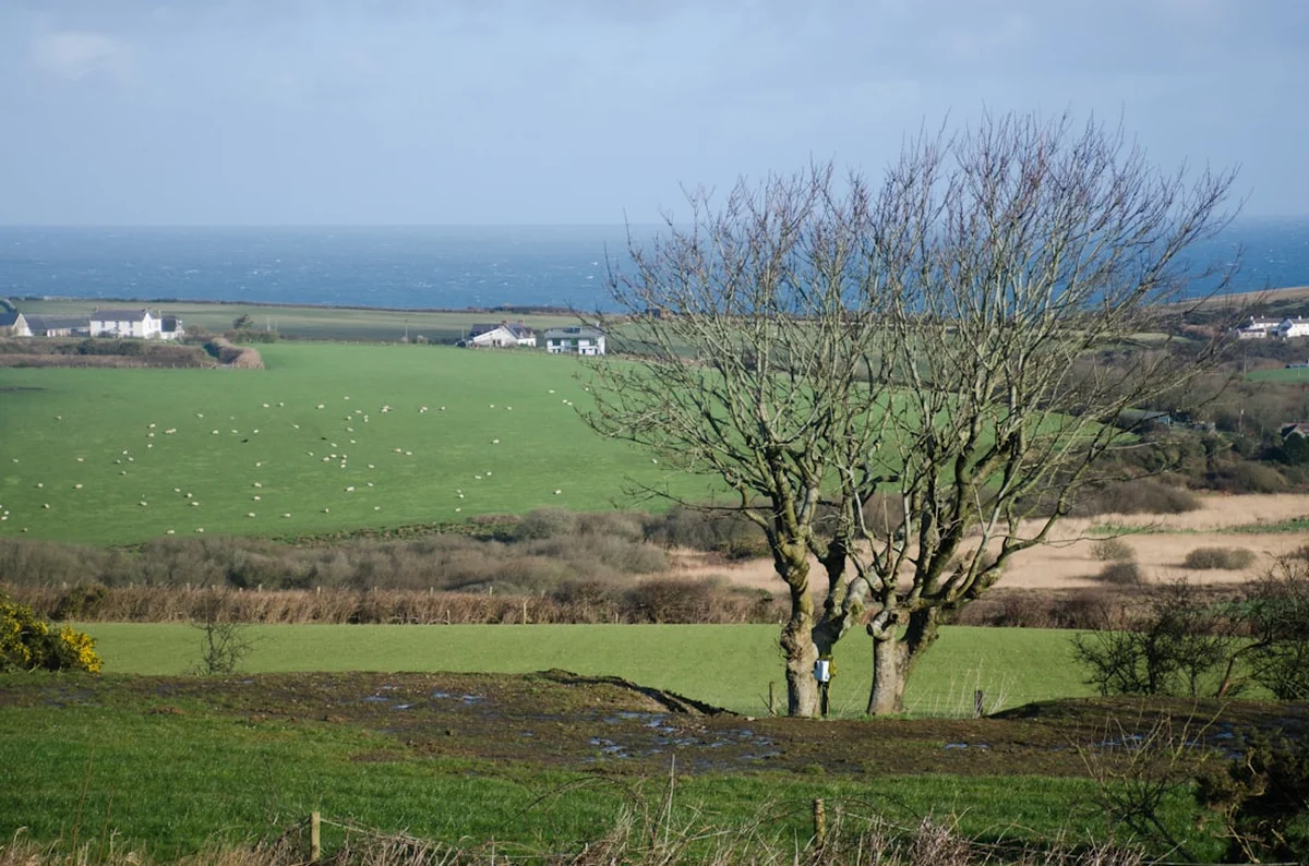
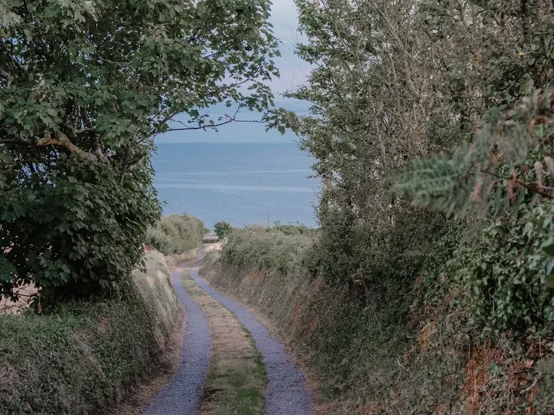
The Pembrokeshire Coast Path is a testament to the enduring power of the sea and the resilience of coastal landscapes. It is the only National Trail in the UK to be located entirely within a National Park, the Pembrokeshire Coast National Park, a designation that underscores its exceptional natural beauty and ecological significance. The path winds its way along the edge of the Celtic Sea, revealing a diverse tapestry of environments. You'll traverse sheer limestone cliffs, where seabirds nest in their thousands, and descend into sheltered coves with turquoise waters and golden sands, perfect for a refreshing dip on a warm day.
The terrain is famously undulating. While the total elevation gain might seem modest compared to mountain trails, the path rarely offers long, flat stretches. Instead, it climbs and descends relentlessly, following the contours of the coastline. Expect steep ascents to cliff tops, followed by equally steep descents to sea level, often involving numerous steps. This constant up-and-down motion makes the path physically demanding, requiring good stamina and strong leg muscles. However, each climb is rewarded with spectacular panoramic views, making the effort entirely worthwhile.
Wildlife is a significant draw for many walkers. The Pembrokeshire coast is a vital breeding ground for a variety of seabirds, including puffins, guillemots, razorbills, and kittiwakes, particularly visible on islands like Skomer and Skokholm. Seals are frequently spotted basking on rocks or playing in the waves, and if you're lucky, you might even catch a glimpse of dolphins or porpoises offshore. The path also meanders through areas of rare coastal heathland and ancient woodlands, showcasing a rich diversity of flora.
The path is well-maintained and waymarked, making navigation relatively straightforward. However, the coastal environment means conditions can change rapidly. Fog can descend unexpectedly, and strong winds can make exposed sections challenging. The path is divided into sections, allowing for flexible itineraries, from day trips to a full multi-day trek. It's a journey that offers a profound connection to the natural world, a chance to disconnect from the everyday and reconnect with the rhythm of the tides and the calls of the seabirds.
History and Cultural Context
The Pembrokeshire Coast Path has a history deeply intertwined with the maritime heritage of Wales. For centuries, this coastline has been a vital artery for trade, fishing, and defence. The path itself follows ancient routes, trodden by smugglers, fishermen, farmers, and soldiers. Many sections of the path were originally used as coastal defence routes or as tracks for farmers to access grazing land on the cliff tops.
The idea of a continuous coastal path began to gain traction in the mid-20th century. Following the establishment of the Pembrokeshire Coast National Park in 1952, efforts were made to create a continuous public right of way around the entire coastline. The Pembrokeshire Coast Path was officially opened as a National Trail in 1970, covering 299.3 km (299 km) of the most scenic and accessible coastal land. Its creation was a significant achievement, involving negotiations with landowners and the establishment of new rights of way.
The path passes through numerous historic sites, including Iron Age hill forts, medieval castles (such as Pembroke Castle and St Davids Cathedral), and remnants of industrial heritage like old lime kilns and former quarry sites. The villages and towns along the route, such as Solva, Tenby, and St Davids, have their own rich histories, often linked to seafaring and fishing traditions. St Davids, the smallest city in the UK, is a significant pilgrimage site, home to the magnificent 12th-century cathedral.
The path's development also reflects a growing appreciation for the natural environment and the importance of public access to it. The Pembrokeshire Coast National Park Authority plays a crucial role in maintaining the path, ensuring its accessibility, and protecting the unique landscape and wildlife it traverses. The path is a living testament to the region's past, present, and future, offering a journey through both natural beauty and human history.
Seasonal Highlights and Weather Reality
The Pembrokeshire Coast Path can be walked year-round, but each season offers a distinct experience. The best time for most walkers is generally from April to October, when the weather is typically milder and daylight hours are longer.
Spring (April–May): This is a beautiful time to walk the path. The landscape bursts into bloom with wildflowers, including bluebells, sea campion, and thrift. Seabird colonies begin to return to the cliffs, and the air is filled with their calls. The weather can be variable, with a mix of sunshine and showers, but it's often less crowded than in summer.
Summer (June–August): The warmest months offer the best chance of good weather and calm seas, ideal for enjoying the beaches and swimming. The wildflowers are in full bloom, and the birdlife is at its most active. However, this is also the busiest period, and accommodation can be scarce and expensive. Sandflies can be present, particularly in sheltered, damp areas, though they are generally less of a nuisance than in some other coastal regions.
Autumn (September–October): Autumn can be a magical time to walk the path. The crowds thin out, the light becomes softer and more golden, and the coastal colours are often at their most vibrant. The weather can still be pleasant, with crisp, clear days, though rain becomes more frequent. The sea can be more dramatic, adding to the rugged beauty of the coastline.
Winter (November–March): Walking the Pembrokeshire Coast Path in winter offers a wild and dramatic experience. The coastline is often battered by storms, creating spectacular wave action against the cliffs. The paths can be muddy and slippery, and daylight hours are short. However, you'll have the path largely to yourself, and the stark beauty of the winter coast can be incredibly rewarding for experienced and well-prepared walkers. Be aware that some facilities, such as cafes and accommodation, may be closed during the winter months.
Weather Considerations: Pembrokeshire's coastal weather is notoriously changeable. Expect sunshine, rain, wind, and fog, sometimes all in the same day. Always check the forecast before setting out and be prepared for all conditions. Coastal paths can be exposed, so strong winds are a common factor. Sea mist can also reduce visibility significantly, especially on higher sections of the path.
Recommended Itinerary

14-Day Pembrokeshire Coast Path Itinerary
This itinerary divides the 299 km path into manageable daily stages, averaging around 21 km per day. It can be adjusted based on fitness levels and desired pace.
Day 1: St. Dogmaels to Newport (21 km)
- Start at the northern trailhead in St. Dogmaels.
- Walk through sheltered estuaries and open coastline.
- Pass the picturesque village of Moylegrove.
- Arrive in the charming market town of Newport.
Day 2: Newport to Fishguard (18 km)
- Follow the coast past Dinas Head, offering stunning views.
- Descend to the harbour town of Fishguard.
Day 3: Fishguard to Strumble Head and Lower Town (20 km)
- A scenic day exploring the dramatic headland of Strumble Head with its lighthouse.
- Continue to the picturesque Lower Town of Fishguard.
Day 4: Lower Town to Abercastle (17 km)
- Walk along a rugged stretch of coastline with hidden coves.
- Pass through the small, sheltered harbour of Abercastle.
Day 5: Abercastle to St. Davids (19 km)
- A significant day leading to the UK's smallest city.
- Pass through Whitesands Bay, a popular surfing beach.
- Arrive in St. Davids, with its magnificent cathedral.
Day 6: St. Davids to Porthgain (15 km)
- Explore the coastline around St. Davids, including St. Justinians lifeboat station.
- Visit the unique industrial harbour of Porthgain.
Day 7: Porthgain to Lower Solva (16 km)
- A day of dramatic cliffs and sea stacks.
- Arrive in the picturesque harbour village of Lower Solva.
Day 8: Lower Solva to St. Davids (via ferry if desired) or continue to Nolton Haven (22 km)
- Option to explore St. Davids further or continue along the coast.
- Pass through beautiful sandy bays.
- Reach Nolton Haven.
Day 9: Nolton Haven to Marloes Sands (18 km)
- A day of stunning beaches and coastal scenery.
- Pass through the Dale Peninsula.
- Arrive at the magnificent Marloes Sands.
Day 10: Marloes Sands to Little Haven (17 km)
- Explore the wild beauty of the western tip of Pembrokeshire.
- Pass islands like Skomer and Skokholm (boat trips available).
- Reach the charming village of Little Haven.
Day 11: Little Haven to Broad Haven and Haverfordwest (20 km)
- Walk along popular sandy beaches.
- The path heads inland slightly towards Haverfordwest, the county town.
Day 12: Haverfordwest to Milford Haven (25 km)
- A longer day, following the Cleddau Estuary.
- Pass through the historic port town of Milford Haven.
Day 13: Milford Haven to Stackpole Quay (22 km)
- A day of diverse coastal scenery, including sandy bays and rocky headlands.
- Pass through the National Trust's Stackpole Estate.
- Arrive at the picturesque Stackpole Quay.
Day 14: Stackpole Quay to Amroth (18 km)
- The final stretch of the path.
- Pass through the beautiful Barafundle Bay and Freshwater East.
- End at the village of Amroth, the southern terminus of the path.
Notes:
- This is a challenging route; consider your fitness and experience.
- Accommodation should be booked well in advance, especially during peak season.
- Public transport links are available at various points for shorter sections or bail-out options.
- Carry sufficient water and food, as facilities can be sparse between villages.
Planning and Bookings
Book Your Trip
Everything you need to plan your journey
Accommodation
Find places to stay near St Dogmaels
Flights
Search flights to St Dogmaels
Essential Preparation
Planning is crucial for a successful Pembrokeshire Coast Path trek. Given its length and the undulating terrain, breaking it down into manageable sections is key. Consider your fitness level and the time you have available. Many walkers opt to complete the path in stages over several years. For a continuous trek, booking accommodation and arranging luggage transfer services well in advance is essential, particularly during the peak season (May to September).
The primary logistical hub for the Pembrokeshire Coast Path is Haverfordwest, which has good transport links. However, many walkers prefer to base themselves in smaller towns and villages along the route, such as St. Davids, Tenby, Fishguard, or Newport, depending on the section they are walking. Researching public transport options (buses and trains) is vital for accessing trailheads and arranging onward travel. Many local taxi services also offer transfers between villages.
Trail Accommodation
Accommodation options along the Pembrokeshire Coast Path are varied and generally plentiful, especially in the larger towns and villages. However, booking in advance is highly recommended, particularly during the summer months and bank holiday weekends.
Types of Accommodation:
- Hotels and Guesthouses: Available in most towns and larger villages, offering comfortable rooms and amenities.
- Bed & Breakfasts (B&Bs): A popular choice, offering a more personal touch and often including a hearty Welsh breakfast.
- Self-Catering Cottages: Ideal for groups or those seeking more independence, providing kitchen facilities.
- Hostels: Several YHA (Youth Hostels Association) hostels are located along the path, offering budget-friendly dormitory-style accommodation.
- Campsites: Numerous campsites are available, ranging from basic sites to those with full facilities. Wild camping is generally not permitted along the National Trail due to land ownership and conservation regulations, so always use designated campsites.
Booking Requirements:
- Bookings are essential for most accommodation types, especially during peak season (May-September).
- For hostels and campsites, booking online or by phone is usually required.
- Consider booking accommodation that offers luggage transfer services if you plan to walk continuously.
Facilities Provided: Varies by establishment, but typically includes beds, bedding, private or shared bathrooms, and breakfast for B&Bs and hotels. Campsites provide pitches and often communal facilities like toilets and showers. Hostels offer bunk beds and shared facilities.
What's NOT Provided: Unless specified, expect to provide your own toiletries, towels (though often provided in hotels/B&Bs), and food (except breakfast in B&Bs/hotels). Campsites typically do not provide cooking equipment.
Seasonal Availability: Most accommodation operates from spring through autumn. Some establishments may close during the winter months (November-March), so always check availability.
Costs: Prices vary significantly. Budget options like campsites and hostels can range from £20-£40 per person per night. B&Bs and guesthouses typically cost £60-£120 per room per night. Hotels can be more expensive. Self-catering cottages vary widely based on size and location.
Required Gear
- Waterproof Hiking Boots: Sturdy, waterproof, and well-broken-in boots with good ankle support are essential due to the uneven and often wet terrain.
- Waterproof Jacket and Trousers: Essential for protection against the unpredictable coastal weather. Look for breathable, taped-seam options.
- Layered Clothing: A system of base layers (merino wool or synthetic), insulating mid-layers (fleece or down jacket), and an outer shell is recommended to adapt to changing temperatures.
- Backpack: A comfortable daypack (20-30 litres) for daily essentials, or a larger pack (45-65 litres) if carrying all your gear for multi-day treks. A rain cover is advisable.
- Navigation Tools: Ordnance Survey (OS) maps (Explorer series OL17 and OL35), a compass, and a GPS device or smartphone with offline mapping apps are recommended. The path is generally well-waymarked, but navigation skills are important, especially in poor visibility.
- First-Aid Kit: Including blister plasters, antiseptic wipes, pain relievers, bandages, and any personal medications.
- Head Torch: With spare batteries, useful for early starts, late finishes, or in case of unexpected delays.
- Sun Protection: Sunscreen, sunglasses, and a wide-brimmed hat, as the sun can be intense, especially reflecting off the sea.
- Walking Poles: Highly recommended for stability on steep ascents and descents, and to reduce strain on knees.
What to Bring
- Food and Water: Carry sufficient water (at least 1-2 litres per person per day) and high-energy snacks. Villages and towns offer opportunities to resupply, but there can be long stretches between them.
- Water Bottle or Hydration Reservoir: Ensure you have a reliable way to carry water.
- Toiletries: Biodegradable soap, toothbrush, toothpaste, toilet paper, hand sanitiser.
- Insect Repellent: While not as severe as some locations, midges and sandflies can be present, especially in sheltered, damp areas during warmer months.
- Camera: To capture the stunning scenery.
- Mobile Phone: For emergencies, though signal can be intermittent along the coast. Consider a portable power bank.
- Towel: Quick-drying travel towel.
- Swimsuit and Towel: For spontaneous dips in the sea at the many beautiful beaches.
- Book or Journal: For relaxing evenings.
- Cash: Some smaller establishments or remote cafes may not accept card payments.
Permits
No specific permits are required to walk the Pembrokeshire Coast Path itself. As a designated National Trail, it is open to the public for walking and recreation. However, there are a few points to consider regarding access and activities:
- National Park Access: The entire path lies within the Pembrokeshire Coast National Park. While no permit is needed for walking, visitors are expected to respect the park's regulations, which aim to protect its natural beauty and wildlife.
- Island Access: If you plan to visit islands like Skomer, Skokholm, or Ramsey for birdwatching, separate boat trip tickets are required. These are booked through specific boat operators and can sell out quickly, especially for Skomer during puffin season (April-July).
- Camping: Wild camping is generally not permitted along the National Trail. You must use designated campsites. Booking campsites in advance is strongly advised, particularly during peak season.
- Private Land: While the path is a public right of way, it may cross private land. Always stay on the marked path and respect any signage or restrictions.
- Conservation Areas: Some sections of the path pass through sensitive ecological areas or nature reserves. Adhere to any specific guidelines provided for these locations to minimise disturbance to wildlife and habitats.
The beauty of the Pembrokeshire Coast Path is its accessibility. The primary requirement is simply to walk responsibly and enjoy the stunning scenery.
Other Activities in the Area
Beyond walking the Pembrokeshire Coast Path, the region offers a wealth of activities to enhance your visit:
- Wildlife Watching and Boat Trips: The islands off the coast, such as Skomer, Skokholm, and Ramsey, are world-renowned for their seabird colonies, including puffins, guillemots, and razorbills. Boat trips to these islands are a must for nature enthusiasts. Seal spotting is also popular, with large colonies often seen basking on rocks.
- Coasteering: Pembrokeshire is a mecca for coasteering, an adventurous activity that combines swimming, scrambling, climbing, and cliff jumping along the coastline. Several adventure centres offer guided coasteering experiences.
- Kayaking and Paddleboarding: Explore the sheltered bays and coves by kayak or paddleboard. Many rental centres and guided tours are available, offering a unique perspective of the coastline.
- Surfing and Watersports: Beaches like Whitesands Bay, Newgale, and Freshwater West are popular spots for surfing, with lessons and equipment hire available.
- Visiting Castles and Historic Sites: Pembrokeshire is rich in history. Explore magnificent castles such as Pembroke Castle, Carew Castle, and Roch Castle, or visit the historic St Davids Cathedral.
- Exploring Charming Villages: Wander through picturesque fishing villages like Solva, Abercastle, and Little Haven, enjoying local crafts, galleries, and seafood.
- Cycling: While the coast path is for walkers, there are numerous cycle routes in the surrounding countryside and along quieter lanes.
- Stargazing: Pembrokeshire has some of the darkest skies in the UK, particularly in the west. Designated Dark Sky Parks offer incredible opportunities for stargazing.
Safety and Conditions
The Pembrokeshire Coast Path is a beautiful but wild environment. Prioritising safety is paramount for an enjoyable experience.
Terrain Hazards:
- Steep Ascents and Descents: The path frequently climbs and descends cliffs, often involving numerous steps. These can be slippery when wet.
- Uneven Ground: Expect rocky, root-strewn, and muddy sections, especially after rain.
- Coastal Erosion: Sections of the path can be affected by coastal erosion. Always heed warning signs and diversions.
- Slippery Surfaces: Rocks and steps can become extremely slippery, particularly in wet or icy conditions.
Weather Hazards:
- Changeable Weather: Coastal weather can change rapidly. Be prepared for strong winds, heavy rain, fog, and sudden drops in temperature, even in summer.
- High Winds: Exposed cliff tops can be buffeted by strong winds, making walking difficult and potentially dangerous.
- Sea Mist: Fog can descend quickly, reducing visibility to near zero. This is particularly hazardous on cliff edges.
Wildlife:
- Seabirds: During nesting season (spring/summer), be mindful of nesting birds on cliff edges.
- Seals: Maintain a respectful distance from seals basking on rocks.
- Insects: Midges and sandflies can be present, especially in sheltered, damp areas during warmer months.
General Safety Advice:
- Check the Weather Forecast: Always check the Met Office or BBC Weather forecast before you set out and be prepared to change your plans if conditions are poor.
- Inform Someone of Your Plans: Let a friend or family member know your intended route and expected return time.
- Carry a Mobile Phone: Ensure it is fully charged and consider a portable power bank. Signal can be intermittent.
- Carry Adequate Supplies: Bring enough water, food, and appropriate clothing for the conditions.
- Wear Appropriate Footwear: Sturdy, waterproof hiking boots are essential.
- Stay on the Marked Path: Do not take shortcuts or venture off the designated trail, especially near cliff edges.
- Be Aware of Tides: Some sections may be affected by high tides; check tide times if walking in areas prone to tidal inundation.
- First Aid: Carry a well-stocked first-aid kit and know how to use it.
- Emergency Services: In a life-threatening emergency, dial 999 or 112 and ask for the Coastguard.
Side Trips and Points of Interest
The Pembrokeshire Coast Path is dotted with numerous points of interest and opportunities for rewarding side trips:
Islands of the Archipelago:
- Skomer Island: A National Nature Reserve and a haven for seabirds, most famously the puffins which nest here in their thousands from April to July. Boat trips depart from Martin's Haven. The island offers stunning cliff scenery and walking trails.
- Skokholm Island: Also a significant bird sanctuary, offering a more remote and wild experience. Access is via boat from Martin's Haven.
- Ramsey Island: Home to a large population of seals and a variety of seabirds. Boat trips depart from St. Justinians.
Beaches and Coves:
- Barafundle Bay: Often cited as one of Britain's most beautiful beaches, accessible only on foot via the coast path. It's a stunning, sheltered sandy cove.
- Marloes Sands: A vast expanse of golden sand, popular with surfers and walkers, with dramatic rock formations and sea stacks.
- Whitesands Bay: A wide, sandy beach near St. Davids, popular for watersports and offering excellent views towards Ramsey Island.
- Freshwater East and West: Two beautiful sandy beaches offering different coastal experiences, with Freshwater West being a renowned surfing spot.
Historic Sites:
- St Davids Cathedral: A magnificent 12th-century cathedral, the spiritual heart of Wales, located in the UK's smallest city.
- Pembroke Castle: The birthplace of Henry VII, this imposing fortress stands dramatically on a tidal inlet.
- Carew Castle and Tidal Mill: A picturesque castle with a restored tidal mill, offering a glimpse into medieval life.
- Iron Age Hill Forts: Numerous ancient forts, such as Castell Henllys, offer insights into the region's prehistoric past.
Natural Wonders:
- Strumble Head Lighthouse: A picturesque lighthouse perched on a rocky islet, accessible via a causeway at low tide. Offers dramatic sea views.
- Porthgain Harbour: A unique, man-made harbour with a fascinating industrial past, now a charming spot with art galleries and a pub.
- The Gribin: A striking ridge of rock formations near St. Davids, offering excellent views and a sense of wildness.
Leave No Trace
The Pembrokeshire Coast Path traverses a fragile and beautiful environment. Adhering to Leave No Trace principles is crucial to preserving its natural and cultural heritage for future generations.
Plan Ahead and Prepare:
- Research the trail, weather, and local conditions before you go.
- Pack appropriately for the conditions to minimise the need for emergency assistance.
- Book accommodation and transport in advance, especially during peak season.
Travel and Camp on Durable Surfaces:
- Stick to the marked path to avoid damaging vegetation and causing erosion.
- Use designated campsites for overnight stays. Wild camping is not permitted.
Dispose of Waste Properly:
- Pack out everything you pack in, including all food scraps, wrappers, and tissues.
- Use toilet facilities where available. If none exist, dig a cathole at least 60 metres from water sources, trails, and campsites, and bury human waste. Pack out used toilet paper.
Leave What You Find:
- Do not disturb or remove plants, rocks, or historical artefacts.
- Take photographs, not souvenirs.
Minimise Campfire Impacts:
- Campfires are generally not permitted on the Pembrokeshire Coast Path due to fire risk and environmental impact. Use a portable stove for cooking.
Respect Wildlife:
- Observe wildlife from a distance. Do not feed birds or other animals, as it can harm their health and alter their natural behaviour.
- Keep pets under control at all times.
Be Considerate of Other Visitors:
- Yield to other walkers, especially on narrow sections.
- Keep noise levels down and avoid playing loud music.
- Respect the local communities and their way of life.