Prince Edward Island Coastal Trail - The Island Walk
The Prince Edward Island Coastal Trail, colloquially known as "The Island Walk," is Canada’s most ambitious long-distance walking circuit—a 700-kilometre odyssey that circumnavigates the perimeter of the nation’s smallest province. Inspired by the legendary Camino de Santiago, this trail offers a profound immersion into the pastoral beauty, rugged coastlines, and maritime culture of Prince Edward Island (PEI). The route is a seamless tapestry of the Confederation Trail (a decommissioned railway line), red dirt roads, quiet secondary highways, and pristine beach stretches. Unlike the steep, lung-busting ascents of the Rockies or the Appalachian Trail, the PEI Coastal Trail is defined by its accessibility and gentle gradients, making it a "thru-hike for everyone" while still presenting a formidable endurance challenge due to its sheer length.
Walking the Island Walk is an exercise in slow travel. It takes the average walker between 30 and 35 days to complete the full loop, though many choose to tackle it in sections over several years. The journey begins and ends in the historic capital of Charlottetown, or at the gateway of Borden-Carleton, leading walkers through iconic landscapes: the towering red sandstone cliffs of the North Shore, the tranquil fishing villages of the Points East Coastal Drive, and the rolling emerald hills of the interior that famously inspired Lucy Maud Montgomery’s Anne of Green Gables. This is a trail where the reward is found in the rhythm of the tides, the hospitality of the "Islanders," and the unparalleled freshness of the local seafood. It is a journey of 700,000 steps across a land defined by the sea.
- Distance: 700.0 km loop
- Duration: 30–40 days (4-6 weeks)
- Season: June to October (peak services July–August)
- Accommodation: B&Bs, inns, hotels, and campsites (pre-booking essential in summer)
- Highest point: Approximately 140 m (near Central Queens)
- Difficulty: Easy (flat to gently rolling terrain)
- Direction: Clockwise or counter-clockwise (clockwise is traditional)
Overview
The Prince Edward Island Coastal Trail is a masterclass in coastal geography and rural charm. While many thru-hikes seek to avoid civilisation, the Island Walk embraces it, weaving through small communities where the local general store serves as a vital waypoint and the community hall might be hosting a lobster supper. The trail is divided into 32 distinct sections, each averaging 20 to 25 kilometres, designed to align with local accommodation hubs. This structure allows walkers to experience the island’s diversity without the need for heavy backcountry camping gear, as most nights are spent in comfortable inns or bed and breakfasts.
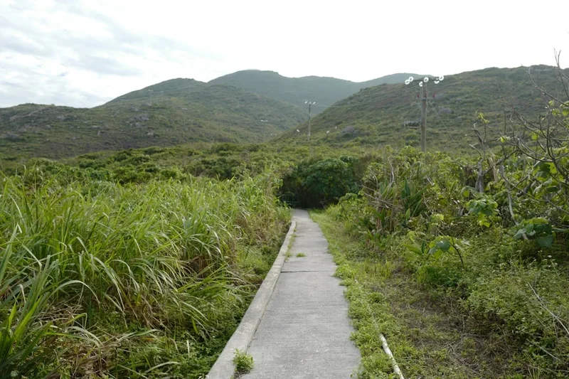
The terrain is remarkably consistent yet visually diverse. Approximately 350 kilometres of the route follow the Confederation Trail, a tip-to-tip pathway built on the island’s former railway beds. These sections are flat, well-drained, and lined with wildflowers, providing a meditative walking experience through hardwood forests and over historic trestle bridges. The remaining 350 kilometres transition to the island’s famous red dirt roads—unpaved lanes that glow a deep ochre against the vibrant green of potato fields—and paved secondary roads that hug the coastline. In certain sections, particularly within the Prince Edward Island National Park, walkers can choose to trek directly along the sandy shores, feeling the salt spray of the Gulf of St. Lawrence.
What sets this trail apart is the "Island pace." There are no jagged peaks to conquer, but the challenge lies in the daily consistency of 20-kilometre marches. The elevation gain is minimal—only 800 metres over the entire 700-kilometre loop—but the exposure to the elements is significant. Walkers are often at the mercy of the Atlantic winds and the shifting maritime weather. However, the logistical ease of the trail, combined with the frequent opportunities for world-class culinary experiences (from Malpeque oysters to world-famous COWS ice cream), makes it a unique hybrid of a wilderness trek and a cultural pilgrimage. It is a trail that demands stamina rather than technical skill, rewarding the persistent walker with a deep, cellular understanding of the island’s soul.
History and Cultural Context
The history of the land traversed by the PEI Coastal Trail begins with the Mi’kmaq, the Indigenous people who have inhabited Epekwitk (Prince Edward Island) for over 12,000 years. To the Mi’kmaq, the island was formed by the Great Spirit, Glooscap, who laid red clay on the blue waters of the Gulf. Many of the paths followed by the trail today align with ancient portage routes and coastal settlements. Understanding the Mi’kmaq connection to the land—specifically their stewardship of the sea and the forests—is essential for any walker seeking a deeper connection to the route.
European history on the island is equally layered. The trail passes through Acadian regions in the Evangeline area, where the French language and culture remain vibrant despite the Great Upheaval of 1755. Walkers will see the iconic Acadian flag—the French tricolour with a gold star—flying proudly over coastal farms. In 1864, Charlottetown hosted the historic conference that led to the birth of the Canadian Confederation, earning the island the title "Cradle of Confederation." The very railway that now forms the backbone of the trail (the Confederation Trail) was the primary reason PEI joined Canada in 1873, as the colonial government had incurred massive debts during its construction.
The modern "Island Walk" was officially launched in 2019 by Bryson Guptill and a group of dedicated volunteers from the Island Trails organisation. Their vision was to create a world-class walking circuit that utilised existing infrastructure to showcase the entire island. By connecting the rail trail with scenic coastal roads, they created a loop that rivals the great walks of Europe. Today, the trail serves as a living museum, passing by 19th-century lighthouses, historic fishing stages, and the landscapes that inspired the world’s most famous redhead, Anne Shirley. Every kilometre of the trail tells a story of resilience, from the farmers tilling the red soil to the fishers braving the North Strait.
Want more background? Read extended notes on history and cultural context → Learn more
Seasonal Highlights and Weather Reality
The window for completing the full PEI Coastal Trail is relatively narrow, dictated by the harsh North Atlantic winters and the seasonal nature of island tourism. The official season runs from June to October, with each month offering a distinct character.
June: This is the month of awakening. The island is at its greenest, and the lupins—vibrant purple and pink wildflowers—blanket the roadsides. However, June is also "black fly and mosquito season," particularly on the wooded sections of the Confederation Trail. Walkers should be prepared with repellent and head nets. Temperatures are mild, ranging from 15°C to 22°C.
July and August: These are the peak summer months. The weather is warmest (20°C to 28°C), and the ocean temperatures become pleasant for a post-walk swim. This is the busiest time on the island; accommodation must be booked months in advance, and popular coastal sections will have more vehicle traffic. The humidity can be high, making the inland sections feel significantly warmer.
September: Many locals consider this the best time for the Island Walk. The "summer crowds" have thinned, the biting insects have vanished, and the air is crisp and clear. The harvest season is in full swing, and the farm stands are overflowing with local produce. Temperatures are ideal for long-distance walking, averaging 18°C.
October: The island transforms into a tapestry of gold and orange as the hardwood forests change colour. The weather becomes more unpredictable, with increased wind and the possibility of early autumn storms. Many seasonal B&Bs and restaurants close after the Canadian Thanksgiving (mid-October), so logistics require careful planning. However, the solitude and the autumn light make for spectacular photography.
Winter (November to May): The trail is not maintained for walking during the winter. Heavy snow blankets the island, and the Confederation Trail is turned over to snowmobile use. Attempting a thru-hike in winter is not recommended due to extreme cold, lack of services, and safety concerns on the road sections.
Recommended Itinerary
The 32-Day Island Walk Circuit
Week 1: The Gateway and Red Sands Shore (Borden-Carleton to Summerside)
- Day 1: Borden-Carleton to Victoria-by-the-Sea (22 km). Start at the foot of the Confederation Bridge. Flat coastal roads with views of the Northumberland Strait.
- Day 2: Victoria-by-the-Sea to Cornwall (24 km). Rolling hills through the "Red Sands Shore" region.
- Day 3: Cornwall to Charlottetown (18 km). Entry into the historic capital via the Brighton Boardwalk.
- Day 4: Charlottetown to Mount Stewart (28 km). Transition onto the Confederation Trail. Deep forest and river views.
- Day 5: Mount Stewart to St. Peters Bay (25 km). One of the most beautiful sections, hugging the coastline of the bay.
- Day 6: St. Peters Bay to Naufrage (22 km). Transition back to coastal roads and red dirt lanes.
- Day 7: Naufrage to Elmira (24 km). Arrival at the eastern terminus of the old railway.
Week 2: Points East Coastal Drive (Elmira to Murray River)
- Day 8: Elmira to East Point (12 km). A shorter day to visit the East Point Lighthouse where the tides meet.
- Day 9: East Point to Souris (26 km). Dramatic cliffside walking and white sand beaches like Basin Head.
- Day 10: Souris to Cardigan (28 km). Inland through quiet farming communities.
- Day 11: Cardigan to Montague (12 km). A short, scenic walk along the Brudenell River.
- Day 12: Montague to Murray River (22 km). Through the lush, forested south-eastern corner of the island.
- Day 13: Murray River to Belfast (24 km). Coastal views of the Northumberland Strait return.
- Day 14: Belfast to Wood Islands (18 km). Arrival at the ferry terminal connecting PEI to Nova Scotia.
Week 3: The South Shore and Central Queens (Wood Islands to Cavendish)
- Day 15: Wood Islands to Little Sands (15 km). High cliffs and spectacular ocean vistas.
- Day 16: Little Sands to Point Prim (22 km). Visit the oldest lighthouse on the island.
- Day 17: Point Prim to Vernon River (24 km). Moving inland through the heart of the island's agricultural belt.
- Day 18: Vernon River to Hunter River (28 km). The most "mountainous" section (gentle rolling hills).
- Day 19: Hunter River to North Rustico (22 km). Descending back toward the North Shore.
- Day 20: North Rustico to Cavendish (12 km). Walking through the PEI National Park. Red cliffs and dunes.
- Day 21: Cavendish to New London (18 km). The heart of "Anne's Land."
Week 4: The North Cape Coastal Drive (New London to Borden-Carleton)
- Day 22: New London to Kensington (15 km). Return to the Confederation Trail.
- Day 23: Kensington to Summerside (20 km). Easy, flat walking into the island's second city.
- Day 24: Summerside to Miscouche (12 km). Acadian history and the Musee Acadien.
- Day 25: Miscouche to Wellington (20 km). Through the heart of the Evangeline region.
- Day 26: Wellington to O'Leary (28 km). Long stretches of pristine forest on the rail trail.
- Day 27: O'Leary to Tignish (30 km). The longest day, reaching the northern tip of the rail trail.
- Day 28: Tignish to North Cape (14 km). Reaching the northernmost point of the island.
- Day 29: North Cape to Miminegash (24 km). Rugged, wind-swept western coastline.
- Day 30: Miminegash to Cedar Dunes (26 km). Walking toward the West Point Lighthouse.
- Day 31: Cedar Dunes to Abram-Village (28 km). Returning to the Acadian shore.
- Day 32: Abram-Village to Borden-Carleton (30 km). The final push back to the bridge.
Important Notes:
- Distances are approximate and can vary based on accommodation locations.
- The trail is not signposted as "The Island Walk" in its entirety; walkers must use the official GPS maps.
- Many walkers choose to take "rest days" in Charlottetown, Summerside, or Cavendish.
- Taxi shuttles are available in many areas to transport luggage between B&Bs.
Planning and Bookings
Book Your Trip
Everything you need to plan your journey
Accommodation
Find places to stay near Charlottetown
Flights
Search flights to Charlottetown
Essential Preparation
The PEI Coastal Trail requires more logistical planning than a typical wilderness hike because it relies on a network of private accommodations rather than a centralised hut system. Fitness requirements are moderate; while the terrain is flat, walking 20–25 kilometres daily for a month requires significant cardiovascular endurance and, more importantly, "toughened" feet. It is highly recommended to complete several back-to-back 20 km training walks with a weighted pack before attempting the full loop.
Charlottetown is the primary hub for logistics. It is home to the island’s main airport (YYG) and numerous outdoor retailers where you can purchase fuel, maps, and last-minute gear. Most walkers spend 1–2 days in Charlottetown at the start to finalise their transport and food supplies. If you are starting in Borden-Carleton, you can reach it via the Maritime Bus from the airport or a local taxi.
Trail Accommodation
Accommodation on the Island Walk is diverse, ranging from luxury inns to simple community campsites. Because the trail passes through popular tourist zones, booking 4–6 months in advance is mandatory for July and August treks.
Types of Accommodation:
- Bed and Breakfasts: The most common choice. They offer a "home away from home" feel and usually include a substantial breakfast—vital for a long day of walking.
- Inns and Hotels: Found in larger centres like Charlottetown, Summerside, and Montague.
- Campsites: Available in Provincial Parks (e.g., Cedar Dunes, Cabot Beach) and private campgrounds. Note that "wild camping" is generally not permitted on PEI, as most land is privately owned.
- Community Halls: In some remote sections, local communities have opened halls for walkers (check the official Island Walk website for current listings).
Facilities and Costs:
- Most B&Bs range from $120 to $200 CAD per night.
- Luggage transfer services (e.g., MacQueen's Bike Shop or local taxis) can move your bags for $30–$50 per jump, allowing you to walk with only a daypack.
- WiFi and electricity are standard in almost all indoor accommodations.
- Laundry facilities are available in larger towns and some B&Bs.
Required Gear
- Footwear: High-quality walking shoes or trail runners are preferred over heavy leather boots. The terrain is mostly hard-packed gravel or pavement; cushioning is more important than ankle support.
- Socks: Merino wool blend (e.g., Darn Tough or Smartwool). Bring at least 3 pairs and change them mid-day to prevent blisters.
- Rain Gear: A lightweight, breathable waterproof jacket. PEI weather can change rapidly.
- Pack: A 30–40L daypack if using luggage transfer, or a 50–65L pack if carrying all gear. Ensure it has a high-quality rain cover.
- Navigation: A smartphone with the "AllTrails" or "Ride with GPS" app and the official Island Walk route downloaded. A backup power bank is essential.
- Sun Protection: Wide-brimmed hat, polarized sunglasses, and SPF 50+ sunscreen. Much of the trail is exposed with little shade.
What to Bring
- Water Treatment: While tap water is safe in towns, a filtered bottle (like a LifeStraw or Sawyer Squeeze) is useful for long stretches between communities.
- First Aid: Focus heavily on blister care (Compeed, moleskin, Leukotape). Include ibuprofen, antihistamines, and any personal medications.
- Insect Repellent: DEET or Picaridin-based spray for black flies and mosquitoes, especially in June and July.
- Food: You do not need to carry 30 days of food. Carry 1 day of emergency rations (energy bars, nuts). Most days end near a grocery store or restaurant.
- Toiletries: Biodegradable soap, travel-sized toothpaste, and a quick-dry microfibre towel.
- Clothing: Moisture-wicking layers. Avoid cotton. A lightweight fleece or "puffy" jacket is needed for cool maritime evenings.
Permits

One of the greatest advantages of the Prince Edward Island Coastal Trail is that no overarching permit is required to walk the route. The Confederation Trail is a public provincial park and is free for all non-motorised users. However, there are specific fees and regulations walkers must be aware of when traversing certain sections.
National Park Entry: The trail passes through the Prince Edward Island National Park (Cavendish and Greenwich sections). Walkers are technically required to have a valid Parks Canada pass to use these trails. You can purchase a daily pass at entry gates or a Discovery Pass if you plan to visit multiple National Parks in Canada. Daily fees are approximately $9.00 CAD per adult.
Camping Permits: If you plan to camp, you must book and pay for sites individually through the PEI Provincial Parks website or the Parks Canada reservation system. There is no "backcountry permit" that covers multiple sites. Prices for campsites typically range from $25 to $45 CAD per night.
Bridge and Ferry Fees:
- Confederation Bridge: Pedestrians are NOT permitted to walk across the 12.9 km bridge. You must take the shuttle service from Borden-Carleton (PEI) to Cape Jourimain (New Brunswick) or vice versa. The fee is approximately $4.75 CAD for a round trip (paid only when leaving the island).
- Northumberland Ferry: If you choose to exit or enter via Wood Islands, the ferry fee is approximately $20 CAD for foot passengers (paid only when leaving the island).
Private Land: Much of the "Coastal Road" sections of the trail pass through private property. Walkers must stay on the road shoulder or the designated trail. Trespassing into potato fields or private beach access points is strictly prohibited and can jeopardise the trail's relationship with local landowners.
Other Activities in the Area
Prince Edward Island is a world-class tourism destination. Consider adding these experiences to your itinerary:
- Anne of Green Gables Heritage Place: Located in Cavendish, this is the farmstead that inspired L.M. Montgomery’s novels. A must-visit for literary fans.
- Deep Sea Fishing: Many harbours (like North Rustico or Souris) offer morning fishing excursions for mackerel and cod.
- Culinary Tours: PEI is "Canada’s Food Island." Take a break to enjoy a traditional lobster supper in New Glasgow or sample world-famous Malpeque oysters at a waterfront bar.
- Greenwich Dunes: Part of the National Park, these "parabolic" dunes feature a spectacular floating boardwalk over a pond, leading to a pristine white sand beach.
- Victoria-by-the-Sea: A picture-perfect historic village filled with artisan shops, a chocolate factory, and a small theatre.
- Lighthouse Climbing: Many of the island's lighthouses (like Point Prim or West Point) are open to the public, offering panoramic views of the coastline you are walking.
Safety and Conditions
Road Walking Safety: Approximately 50% of the Island Walk takes place on secondary roads. While these are generally quiet, walkers must remain vigilant. Always walk facing traffic (on the left side of the road in Canada), wear high-visibility clothing or a pack cover, and remove headphones when walking on narrow shoulders. Be particularly cautious during the autumn harvest (September–October) when large farm machinery and potato trucks are frequent on rural roads.
Ticks and Lyme Disease: Like much of Eastern Canada, PEI has a growing population of black-legged ticks which can carry Lyme disease. When walking through tall grass or wooded sections of the Confederation Trail, wear long trousers tucked into socks, use DEET-based repellent, and perform a thorough "tick check" every evening. If you find a tick attached, remove it carefully with tweezers and monitor for a "bullseye" rash.
Weather Exposure: The greatest environmental risk is heat exhaustion and dehydration. Large sections of the trail (especially the red dirt roads) have no tree cover. Carry at least 2–3 litres of water and wear a hat. Conversely, maritime storms can bring sudden temperature drops and heavy rain. Hypothermia is a risk even in summer if you become wet and the wind picks up.
Emergency Services: Cell phone coverage is excellent across 95% of the island. In case of an emergency, dial 911. There are hospitals in Charlottetown and Summerside, and smaller health centres in O'Leary, Alberton, and Montague.
Water Safety: If walking on beaches, be aware of the tides. Some sections of the coast have high cliffs with no escape routes if the tide comes in. Always check the local tide tables before a beach trek. Rip currents are also common on the North Shore; only swim at designated "supervised" beaches within the National Park.
Side Trips and Points of Interest
The Singing Sands (Basin Head): Located near the eastern tip of the island, the sand at Basin Head Provincial Park contains a high amount of silica, which creates a unique "squeaking" or "singing" sound when walked upon. It is consistently ranked as one of the top beaches in Canada and is a perfect spot for a rest day.
The Bottle Houses (Maisons de Bouteilles): In the Acadian village of Cape Egmont, you can visit three buildings constructed entirely from over 25,000 recycled glass bottles. It is a testament to island ingenuity and a colourful detour from the main trail.
Knockwood’s Mi’kmaq Heritage Centre: Located on Lennox Island (accessible via a short bridge near the trail), this centre offers a profound look at the history and culture of the Mi’kmaq people. It is a vital stop for understanding the "First Nations" context of the land.
West Point Lighthouse: This iconic black-and-white striped lighthouse is unique because it also functions as an inn. Staying overnight in a functional lighthouse is a highlight for many thru-hikers. The surrounding Cedar Dunes Provincial Park offers some of the best sunset views on the island.
The Confederation Trail Termini: Make sure to take photos at the "Tip-to-Tip" markers in Tignish (the western terminus) and Elmira (the eastern terminus). These represent the completion of the rail-trail portion of your journey.
Leave No Trace
Prince Edward Island’s beauty is fragile. The red sandstone cliffs are prone to erosion, and the agricultural land is the livelihood of local families. As a walker, you are an ambassador for the trail. Following Leave No Trace principles ensures the trail remains open and welcomed by the community.
Your responsibility as a walker:
- Respect Private Property: Never cross fences or walk through farmers' fields. Stick to the road allowance or the designated trail.
- Waste Management: There are no trash cans on the long stretches of the Confederation Trail. Pack out all your litter, including organic waste like banana peels or apple cores, which can attract pests.
- Protect the Dunes: In the National Park, never walk on the marram grass. The roots of this grass hold the dunes together; a single footprint can start an erosion "blowout." Use designated boardwalks.
- Sanitation: Use public washrooms in towns, gas stations, or trailheads. If you must go in the woods, bury waste in a "cathole" 15 cm deep and at least 60 metres from any water source.
- Wildlife: Do not feed foxes or coyotes. PEI foxes are famously bold; feeding them makes them aggressive and often leads to them being euthanised.
- Fire Safety: Fires are strictly prohibited on the Confederation Trail and on all public beaches. Use only designated fire pits in registered campgrounds.