Paparoa Track - A Journey Through Ancient Landscapes and Living History
The Paparoa Track is New Zealand's tenth Great Walk and the first to be specifically designed as a dual-purpose route for both hikers and mountain bikers. Spanning 55 kilometres across the rugged Paparoa Range on the South Island's wild West Coast, this track represents a significant milestone in the country's conservation and recreation history. It is a journey of profound contrasts, taking travellers from the historic gold-mining remains of the Roaring Meg through high alpine tops with panoramic views of the Tasman Sea, and finally descending into the spectacular limestone canyons of the Pororari River. Unlike many other Great Walks that follow established historical routes, the Paparoa Track was purpose-built to modern standards, offering a high-quality surface that weaves through some of the most diverse ecosystems in the country.
- Distance: 55.0 km one-way
- Duration: 3 days / 2 nights (hiking) or 1–2 days (mountain biking)
- Season: All year round (bookings required; winter conditions can affect alpine sections)
- Huts (mandatory booking): Ces Clark Hut, Moonlight Tops Hut, Pororari Hut
- Highest point: Moonlight Tops (1,010 m)
- Elevation Gain: 1,420 m
- Direction: Generally walked from East (Blackball) to West (Punakaiki)
Overview
The Paparoa Track is more than just a hiking trail; it is a memorial and a testament to the resilience of the West Coast community. Created as a lasting legacy for the 29 miners who lost their lives in the 2010 Pike River Mine disaster, the track was requested by the families of the victims as a way to share the beauty of their loved ones' "backyard" with the world. This emotional weight is felt throughout the journey, particularly at the junction where the Pike29 Memorial Track branches off to the mine portal. The track provides a connection between the inland town of Blackball and the coastal village of Punakaiki, traversing the Paparoa National Park—a region defined by its dramatic karst (limestone) topography, dense podocarp rainforests, and unpredictable maritime weather.
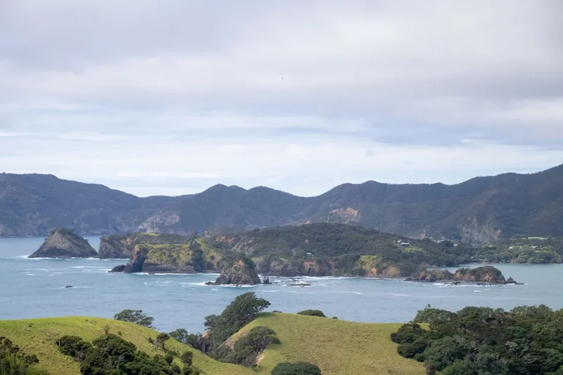
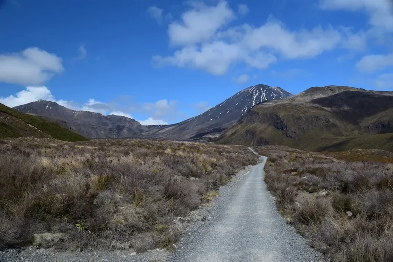
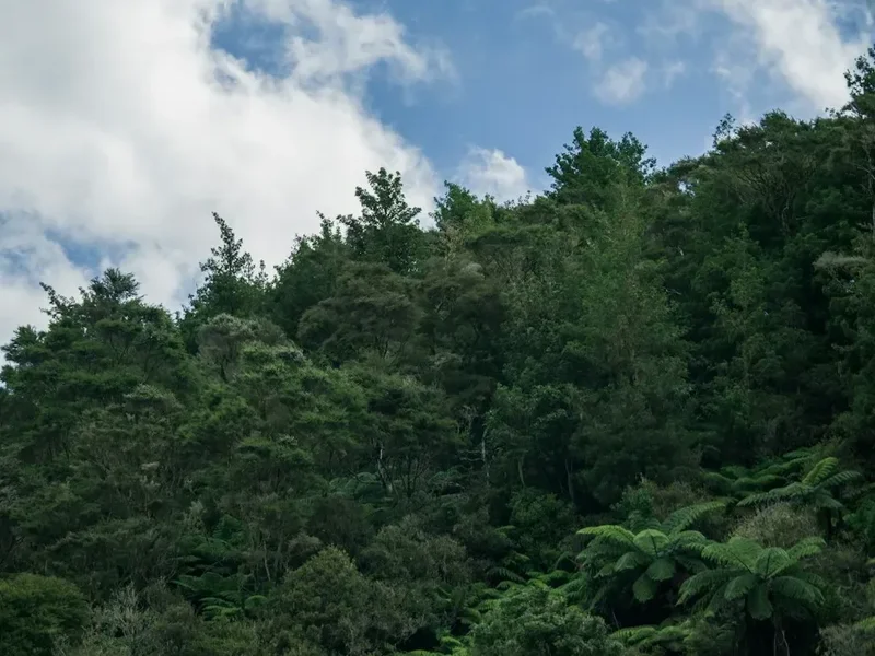
The experience is defined by its geological transitions. The journey begins in the eastern foothills, climbing through montane forest dominated by beech and kamahi. As you reach the alpine zone, the landscape opens into vast tussock grasslands and sub-alpine scrub, where the views extend from the Southern Alps/Kā Tiritiri o te Moana in the east to the crashing waves of the Tasman Sea in the west. The final third of the track is perhaps its most visually stunning, as it drops into the Pororari River valley. Here, the track is carved into towering limestone cliffs, surrounded by lush, prehistoric-looking forests of nikau palms and giant tree ferns. The sound of the river, echoing through the narrow canyons, provides a constant soundtrack to the final kilometres of the walk.
Because the track is dual-use, it has been engineered with a gentle gradient (rarely exceeding 6 degrees), making it one of the most accessible Great Walks for those with moderate fitness. However, the West Coast environment should never be underestimated. The Paparoa Range is the first significant landmass that moisture-laden clouds from the Tasman Sea encounter, resulting in high rainfall and frequent mist. When the clouds clear, the clarity of the light and the scale of the landscape are breathtaking, but walkers must be prepared for the "Roaring Forties" winds that can sweep across the exposed tops with incredible force. This is a landscape that demands respect, offering a deep sense of isolation and wilderness despite its proximity to the coast.
History and Cultural Context
The Paparoa Range has long been a place of significance for Ngāi Tahu, the Māori iwi (tribe) of the South Island. For centuries, the range was a source of seasonal resources and a landmark for those travelling the West Coast in search of pounamu (greenstone). The name "Paparoa" itself refers to the "long mountain range," a fitting description for this formidable barrier between the coast and the inland valleys. The cultural connection to the land remains strong, and the Department of Conservation works closely with Ngāi Tahu to ensure the protection of the region's natural and cultural values.
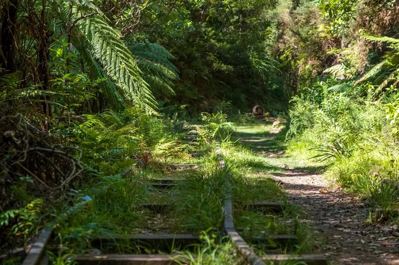
European history in the area is inextricably linked to the extraction of resources—first gold, then coal. The eastern end of the track, starting at the Smoke-ho car park near Blackball, follows part of the historic Croesus Track. This route was originally carved out by gold miners in the late 19th century, and remnants of their efforts, including old water races and mining equipment, can still be seen today. Blackball itself is a town steeped in labour history, being the birthplace of the New Zealand Labour Party following the 1908 "crib time" strike. Walking the first section of the Paparoa Track feels like stepping back into this era of grit and determination.
The most recent and poignant chapter of the track's history is the Pike River Mine disaster. On 19 November 2010, an explosion at the mine trapped 29 men underground. The subsequent recovery efforts and the eventual decision to seal the mine were periods of immense grief for the nation. The families of the Pike 29 proposed the creation of the Paparoa Track as a way to bring economic benefit to the region and to create a living memorial. The track was officially opened in 2019, with the Pike29 Memorial Track (a side-spur leading to the mine site) opening later. This modern history gives the Paparoa Track a unique emotional resonance, making it a journey of reflection as much as recreation.
Want more background? Read extended notes on history and cultural context → Learn more
Seasonal Highlights and Weather Reality
The Paparoa Track is open year-round, but the experience varies significantly between seasons. Unlike the alpine Great Walks of the Southern Alps (like the Milford or Routeburn), the Paparoa Track does not have a formal "closed" season, but the Department of Conservation (DOC) manages it with different levels of service depending on the time of year.
Summer (December to February): This is the most popular time to walk. Days are long, and the temperatures on the tops are generally mild (15–20°C). However, summer is also the peak season for sandflies in the lower valleys and can still bring heavy rain. The views from the Moonlight Tops are most likely to be clear during these months, though the West Coast "sea fret" (coastal mist) can roll in at any time.
Autumn (March to May): Many locals consider this the best time to visit. The weather is often more stable than in summer, with crisp, clear mornings and less wind. The light in autumn is particularly beautiful for photography, casting long shadows across the limestone canyons. Temperatures begin to drop, especially at night, so warm layers are essential.
Winter (June to August): Winter on the Paparoa Track is for the experienced and well-prepared. While the lower sections near Punakaiki remain relatively mild, the alpine tops can experience snow, ice, and sub-zero temperatures. The huts are equipped with wood burners, making for cosy evenings, but the days are short. Snow can occasionally make the track difficult to follow on the tops, and mountain biking is often discouraged or restricted during heavy snow events.
Spring (September to November): Spring brings a burst of life to the rainforest, with waterfalls at their most thunderous due to snowmelt and spring rain. However, this is also the windiest season. The "Roaring Forties" can bring gale-force winds to the exposed ridges between Ces Clark and Moonlight Tops huts. Walkers should be prepared for rapid weather changes and potential track closures if wind speeds become dangerous.
Recommended Itinerary
3-Day Paparoa Track Itinerary (Hiking)
Day 1: Smoke-ho Car Park to Moonlight Tops Hut
- Distance: 19.1 km
- Elevation gain: 800 m
- Time: 7–8 hours
- Start at the Smoke-ho car park, 6 km from Blackball.
- Follow the historic Croesus Track, climbing steadily through beech and podocarp forest.
- Pass the historic Ces Clark Hut (10.3 km mark), a great spot for lunch with views back towards the Grey Valley.
- Enter the sub-alpine zone, where the forest gives way to scrub and tussock.
- Traverse the spectacular escarpment of the Paparoa Range, with views of the Pike River valley.
- Arrive at Moonlight Tops Hut (1,010 m), which offers 360-degree views of the Southern Alps and the Tasman Sea.
- This is a long opening day with significant elevation gain; an early start is essential.
Day 2: Moonlight Tops Hut to Pororari Hut
- Distance: 19.1 km
- Elevation: 150 m gain, 400 m descent
- Time: 5–7 hours
- Begin with a traverse across the open tops, staying high on the ridge for several kilometres.
- Pass the junction with the Pike29 Memorial Track (check status before attempting as a side trip).
- The track begins a long, gradual descent through ancient podocarp forest.
- Look out for the "Ancient Forest" section, where massive Rimu and Kahikatea trees dominate the landscape.
- Cross several impressive suspension bridges over deep ravines.
- Arrive at Pororari Hut, perched on a ridge overlooking the Pororari River and the Tasman Sea.
- The sunset from Pororari Hut is often cited as a highlight of the entire Great Walk.
Day 3: Pororari Hut to Punakaiki
- Distance: 16.8 km
- Elevation: 450 m descent
- Time: 4–5 hours
- Descend from the hut into the upper reaches of the Pororari River valley.
- The track follows the river, which has carved deep into the limestone bedrock.
- Pass through the "Limestone Canyons," where 100-metre-high cliffs tower over the track.
- The vegetation changes to coastal forest, featuring nikau palms and large ferns.
- The final section follows the Pororari River Track, a popular day-walk route.
- Finish at the Pororari River car park in Punakaiki.
- Celebrate your finish with a visit to the famous Pancake Rocks and Blowholes, just 1 km south of the track end.
Important Notes:
- The track can be walked in either direction, but East to West is preferred for the gradual descent into the limestone canyons.
- Mountain bikers typically complete the track in 1 or 2 days, staying at Moonlight Tops Hut.
- There is no camping allowed on the track; you must stay in the DOC huts.
- Water is available at all huts but should be treated or boiled.
- The track is well-marked, but the alpine section requires navigation awareness in thick mist.
Planning and Bookings
Book Your Trip
Everything you need to plan your journey
Accommodation
Find places to stay near Greymouth
Flights
Search flights to Greymouth
Essential Preparation
The Paparoa Track requires careful logistical planning, primarily because it is a one-way through-track. The start (Smoke-ho) and end (Punakaiki) are approximately 1.5 hours apart by road. Most walkers choose to leave their vehicle at one end and use a commercial shuttle service or car relocation service. Several operators in Blackball, Greymouth, and Punakaiki specialise in these services. It is highly recommended to book your transport at the same time as your hut bookings.
Fitness requirements are moderate. While the track surface is excellent, the daily distances (nearly 20 km on the first two days) are substantial. You should be comfortable walking for 7–8 hours with a multi-day pack. If you are mountain biking, you should be a Grade 3 (Intermediate) rider with experience in backcountry conditions and long climbs.
Base yourself in Greymouth or Blackball the night before you start. Blackball offers a unique West Coast experience with its historic Hilton Hotel (formerly the Blackball Hilton) and local salami shop. Punakaiki has a range of accommodation from campsites to luxury eco-lodges for your post-hike recovery.
Trail Accommodation
There are three purpose-built Department of Conservation huts on the track: Ces Clark Hut, Moonlight Tops Hut, and Pororari Hut. These must be booked in advance through the DOC Great Walks booking system.
Hut Facilities:
- Bunk beds with mattresses in communal sleeping areas (Ces Clark: 20 bunks; Moonlight Tops: 20 bunks; Pororari: 20 bunks).
- Large communal living areas with tables and seating.
- Gas cooktops and fuel provided during the peak season.
- Wood-burning heaters for warmth (firewood provided).
- Rainwater tanks (treatment recommended).
- Internal toilets (composting or flush depending on the hut).
- Solar lighting in common areas (not for charging devices).
- Bicycle storage racks outside the huts.
What Huts Don't Provide:
- Cooking utensils, pots, pans, or plates.
- Bedding, pillows, or sleeping bags.
- Food or snacks for purchase.
- Showers or hot water.
- WiFi or reliable mobile phone coverage.
Costs: During the peak season, huts cost approximately NZ$45–$70 per night for New Zealand residents and higher for international visitors. Prices are lower in the off-season. Always check the DOC website for the most current pricing.
Required Gear
- Footwear: Sturdy tramping boots with good ankle support are recommended, though the high-quality track surface means lightweight hiking shoes are also suitable for fit walkers.
- Clothing: The layering system is vital. Include a moisture-wicking base layer (merino or synthetic), a warm insulating mid-layer (fleece or down), and a high-quality waterproof shell jacket.
- Rain Gear: A seam-sealed waterproof jacket is non-negotiable on the West Coast. Waterproof overtrousers are also highly recommended.
- Pack: A 40–60L tramping pack with a waterproof liner or rain cover.
- Sleeping Bag: A 3-season sleeping bag (rated to 0°C) is sufficient for most of the year.
- Navigation: While the track is well-signposted, carry a physical map and a compass or a GPS device with offline maps.
- Safety: A first aid kit (including blister care), a head torch with spare batteries, and a whistle.
What to Bring
- Food: All meals for 3 days, plus emergency rations for one extra day. Focus on lightweight, high-calorie options like dehydrated meals, nuts, and chocolate.
- Water Treatment: Purification tablets or a lightweight filter. While hut water is generally safe, DOC recommends treatment.
- Cooking Equipment: A lightweight pot, bowl, mug, and cutlery. Matches or a lighter.
- Personal Items: Toiletries (biodegradable), a small travel towel, and sun protection (hat, sunglasses, sunscreen).
- Insect Repellent: Essential for the West Coast sandflies. Look for products with DEET or Picaridin.
- Emergency Communication: A Personal Locator Beacon (PLB) is highly recommended as mobile coverage is non-existent for most of the track. These can be hired in Greymouth or Punakaiki.
Permits
To walk or bike the Paparoa Track, you do not need a "permit" in the traditional sense, but you must have confirmed hut bookings. These bookings serve as your permit to be on the track overnight. The Department of Conservation strictly monitors the huts, and wardens will check your booking confirmation (either printed or on your phone).
Booking Process:
- Bookings typically open in May or June for the following season (July to June).
- Due to the track's popularity and small hut capacities (20 bunks), spots fill up very quickly, often within hours of the booking system opening.
- You must book each hut individually for the specific dates of your journey.
- Payment is required at the time of booking via credit or debit card.
Cancellations and Changes: DOC has a strict cancellation policy. Refunds are usually available if you cancel more than a certain number of days in advance, but a fee is often retained. If the track is closed by DOC due to extreme weather or safety concerns, full refunds are typically provided.
Day Use: If you are only walking a section of the track as a day trip (e.g., the Pororari River section), no booking or fee is required. However, you cannot use the hut facilities (beds or cooking) without a booking.
Other Activities in the Area
The West Coast is a playground for outdoor enthusiasts. Consider these activities before or after your hike:
- Pancake Rocks and Blowholes: Located in Punakaiki, these 30-million-year-old limestone formations are a must-see. Visit at high tide for the best blowhole action.
- Underworld Rafting: Based in nearby Charleston, this involves exploring vast cave systems filled with glowworms and rafting down the Nile River.
- Blackball Salami Company: Visit the famous shop in Blackball to stock up on high-quality cured meats for your hike.
- Truman Track: A short 30-minute walk near Punakaiki that leads to a spectacular beach with a waterfall dropping directly onto the sand.
- Hokitika Gorge: A 1.5-hour drive south of Punakaiki, famous for its impossibly turquoise glacial water and swing bridge.
- The Old Ghost Road: For serious mountain bikers or hikers, this 85 km premier multi-day trail is located further north near Westport.
Safety and Conditions
Weather Awareness: The Paparoa Range is notorious for rapid weather changes. It is not uncommon to experience four seasons in a single day. Before starting, check the MetService "Mountains" forecast for Paparoa National Park. If gale-force winds or heavy snow are forecast for the tops, consider delaying your start. Hypothermia is a genuine risk, even in summer, if you become wet and exposed to the wind.
Dual-Use Etiquette: As a dual-use track, hikers and mountain bikers must share the space. The general rule is that bikers should give way to hikers. Bikers should use a bell or a polite call when approaching from behind. Hikers should stay to the left of the track. Both groups should be mindful on blind corners, especially on the descent into the Pororari Valley.
Alpine Hazards: The section between Ces Clark Hut and Moonlight Tops Hut is highly exposed. There is very little shelter from the wind or rain. In thick mist, visibility can drop to a few metres. The track is well-formed, but you must stay on it to avoid steep drop-offs and to protect the fragile alpine vegetation.
Water Safety: While the track crosses many streams, they are all bridged. However, during extreme rainfall, small side-creeks can swell. Never attempt to cross a flooded stream. The Pororari River can rise rapidly; stay on the elevated track and avoid the riverbed during heavy rain.
Communication: There is no mobile coverage on most of the track. Some signal may be found at specific high points on the Moonlight Tops, but it is unreliable. Carry a PLB for emergencies. All DOC huts have a radio for the warden to communicate with the visitor centre, but these are for official use and emergencies only.
Side Trips and Points of Interest
Pike29 Memorial Track: This 11.6 km (return) side-spur branches off the main Paparoa Track between Moonlight Tops and Pororari Huts. It leads down to the Pike River Mine portal and a memorial site. It is a sombre and moving experience that provides context to the track's existence. Note that this adds significant distance and elevation to your day, so it is usually only attempted by very fit walkers or those staying an extra night.
Garden Gully: Located near the Smoke-ho end, a short detour leads to Garden Gully, where you can see a restored miner's hut and remnants of the gold-mining era. It provides a fascinating glimpse into the harsh conditions faced by early West Coast pioneers.
The Lone Hand: A dramatic rock formation visible from the Moonlight Tops. This jagged granite outcrop stands out against the surrounding landscape and is a favourite subject for photographers.
Pororari River Canyons: While part of the main track, the final 7 km through the limestone canyons is a point of interest in itself. Take the time to look up at the sheer cliffs and observe the way the forest clings to the vertical rock faces. The area is home to the rare Westland Petrel (tāiko), which can sometimes be seen soaring high above the valley.
Leave No Trace
The Paparoa National Park is a pristine wilderness area. To keep it that way, all visitors must follow the Leave No Trace principles. The West Coast environment is particularly sensitive to human impact due to its high rainfall and thin alpine soils.
Key Guidelines:
- Plan Ahead and Prepare: Ensure you have the right gear and skills to avoid needing rescue, which can damage the environment.
- Travel and Camp on Durable Surfaces: Stay on the formed track at all times. Do not take shortcuts on switchbacks, as this causes erosion. Camping is strictly prohibited; use the huts.
- Dispose of Waste Properly: Pack out everything you pack in. This includes food scraps, tea bags, and fruit peels. Use the toilets provided at the huts.
- Leave What You Find: Do not remove plants, rocks, or historical artefacts. The mining remains are protected heritage sites.
- Minimise Campfire Impacts: Fires are not permitted anywhere on the track. Use the gas stoves provided in the huts.
- Respect Wildlife: The Paparoa Range is home to the Great Spotted Kiwi (roroa). Keep your distance and never feed any birds, including the inquisitive weka, which will try to steal your food.
- Be Considerate of Others: Keep noise levels down in the huts and share the track politely with other users.