Panorama Trail Davos - Alpine Majesty
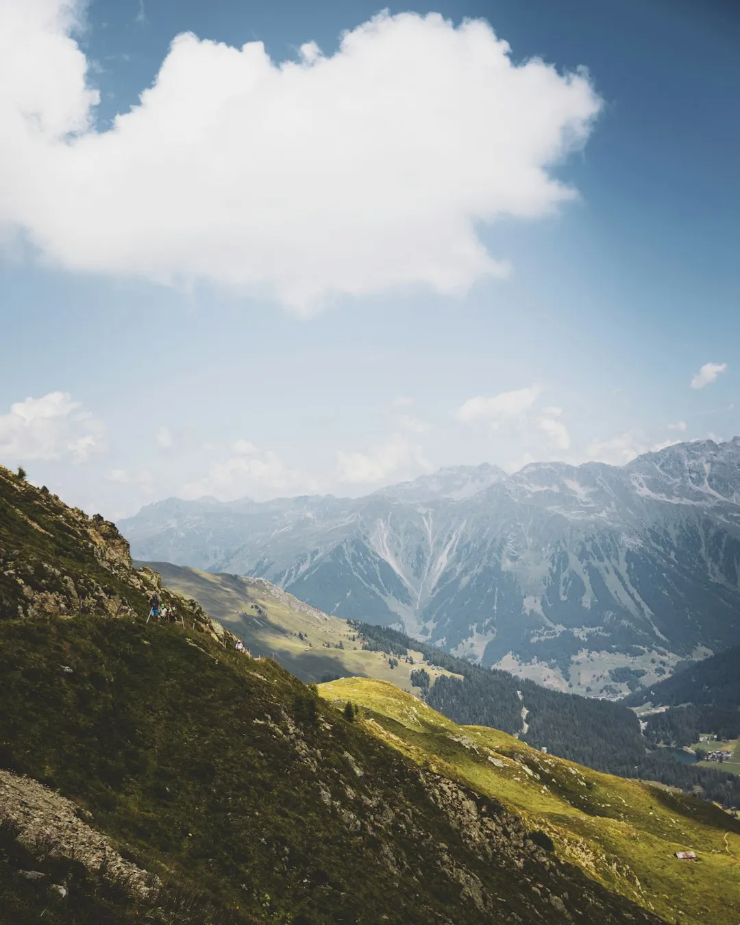
The Panorama Trail Davos is a spectacular multi-day walk in the heart of the Swiss Alps, offering breathtaking vistas and a true sense of alpine immersion. This route is designed for walkers who appreciate expansive mountain scenery, well-maintained trails, and the charm of high-altitude landscapes. While not as remote as some of the world's most challenging treks, it provides a substantial and rewarding experience, showcasing the dramatic beauty of the Graubünden region. The trail winds through alpine meadows dotted with wildflowers, past crystal-clear mountain lakes, and over ridges that provide unparalleled panoramic views of the surrounding peaks and valleys. It's a journey that balances physical exertion with moments of serene contemplation, making it a highlight for any mountain enthusiast visiting Switzerland.
- Distance: 49.0 km
- Duration: 2-3 days
- Season: June to October
- Difficulty: Moderate
- Highest point: Approximately 2,500 metres
- Base town: Davos
- Permits: No specific permits required for hiking
Overview
The Panorama Trail Davos is a testament to the grandeur of the Swiss Alps, offering a continuous display of majestic peaks, verdant valleys, and the crisp, clean air of high altitudes. This trail is not a single, linear path but rather a network of interconnected routes that can be combined to create a personalised multi-day adventure. The core of the experience lies in its name: the panoramic views. From its highest points, walkers are treated to sweeping vistas that stretch for miles, encompassing iconic Swiss mountain ranges, glaciers, and the charming alpine villages nestled below. The trail is well-marked and generally well-maintained, making it accessible to hikers with a moderate level of fitness and experience.
The journey typically begins in or near the renowned resort town of Davos, a hub for winter sports and summer alpine exploration. From there, the trail ascends gradually, often utilising cable cars and gondolas for initial elevation gain, allowing hikers to quickly reach the higher alpine zones. As you progress, the landscape transforms from lush meadows to rugged scree slopes and rocky outcrops. The route is punctuated by opportunities to rest at traditional mountain huts (Berghütten) or alpine restaurants, where you can refuel with hearty Swiss cuisine and soak in the local atmosphere. The diversity of the terrain ensures that each day offers a new perspective and a fresh set of challenges and rewards.
The best time to undertake the Panorama Trail Davos is during the summer months, from June to October, when the snow has melted from the higher passes and the alpine flora is in full bloom. During this period, the weather is generally favourable, though mountain conditions can change rapidly. The trail's moderate difficulty rating means it is suitable for a wide range of hikers, provided they are prepared for sustained ascents and descents and comfortable with heights. The flexibility in duration, allowing for a 2 or 3-day itinerary, caters to different time constraints and fitness levels, making it an adaptable choice for a memorable alpine experience.
History and Cultural Context
The region surrounding Davos has a rich history deeply intertwined with alpine life, trade, and the development of mountain tourism. For centuries, these valleys were primarily inhabited by farmers and herders who adapted to the challenging alpine environment. The discovery of mineral springs in the 19th century led to the transformation of Davos from a humble farming community into a world-renowned spa and health resort, particularly for tuberculosis treatment. This influx of visitors spurred the development of infrastructure, including early hiking trails and mountain transport systems.
The concept of "panoramic" trails gained prominence in the late 19th and early 20th centuries as mountaineering and alpine tourism flourished. As people sought to experience the grandeur of the Alps without the extreme technical demands of climbing, well-marked routes that offered spectacular views became highly sought after. The development of the Panorama Trail Davos is a reflection of this trend, with local authorities and tourism boards investing in creating and maintaining routes that showcase the region's natural beauty to a wider audience. The use of cable cars and gondolas, which began to be established in the mid-20th century, further enhanced accessibility, allowing hikers to bypass some of the steepest initial ascents and reach the higher alpine pastures and ridges more efficiently.
Today, Davos remains a significant centre for both winter sports and summer hiking. The Panorama Trail Davos is a modern iteration of these historical pathways, designed to offer a comprehensive alpine experience. It connects various natural attractions, historical sites, and modern amenities, providing a journey that is not only visually stunning but also culturally enriching. The trail’s existence is a testament to the enduring appeal of the Alps and the Swiss commitment to preserving and sharing their magnificent mountain landscapes.
Seasonal Highlights and Weather Reality
The Panorama Trail Davos is a seasonal walk, with its prime period running from June to October. During these months, the alpine environment is at its most accessible and visually appealing for hikers.
Spring (May to early June): While the lower valleys begin to green and bloom, the higher elevations of the Panorama Trail are typically still covered in snow. Early June might see some lower sections becoming passable, but snowfields can persist on north-facing slopes and at higher altitudes, making navigation challenging and potentially dangerous. This period is generally not recommended for the full trail.
Summer (July to August): This is the peak season for the Panorama Trail. The alpine meadows are vibrant with wildflowers, the days are long, and the weather is generally at its most stable. Temperatures at higher altitudes can be pleasant, though it's crucial to be prepared for cooler conditions and sudden changes. This is the ideal time for experiencing the trail in its full glory, with all huts and restaurants typically open.
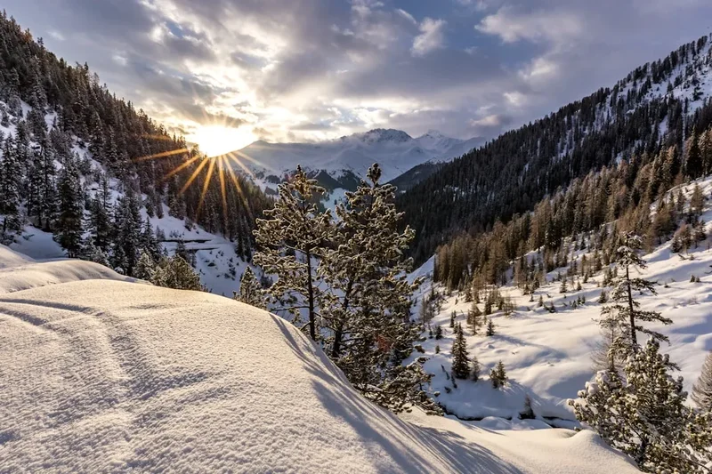
Autumn (September to October): Autumn offers a different kind of beauty. The landscape takes on golden hues as the vegetation changes, and the air becomes crisp and clear. The crowds of summer begin to thin, offering a more tranquil experience. However, the weather can become more unpredictable, with increased chances of early snowfalls, particularly in October. Days become shorter, requiring careful planning of hiking times. By late October, snow can make higher sections impassable.
Weather Considerations: Regardless of the season, mountain weather is notoriously fickle. Even in summer, hikers can encounter rain, strong winds, fog, and even snow at higher elevations. Temperatures can drop significantly with altitude and wind chill. It is essential to check the weather forecast daily and be prepared for all conditions with appropriate gear. The trail's name, "Panorama," implies clear skies, but it is wise to plan for and be equipped for less-than-ideal conditions.
Recommended Itinerary
2-Day Panorama Trail Davos Itinerary
Day 1: Davos Dorf to Sertig Valley (via Jakobshorn)
- Distance: Approximately 15 km
- Elevation gain: Variable, significant ascent and descent, often utilising cable car for initial gain
- Time: 5–7 hours (excluding cable car time)
- Start in Davos Dorf, take the Jakobshorn cable car up to the summit station (approx. 2,500 m)
- Begin hiking from Jakobshorn, enjoying immediate panoramic views
- Descend towards the Jschalp area, passing alpine lakes and meadows
- Continue on well-marked trails, potentially passing through areas like Clavadel
- The route may involve traversing ridges and valleys, offering diverse scenery
- Descend into the picturesque Sertig Valley, known for its traditional Walser architecture and natural beauty
- Overnight accommodation in Sertig (e.g., a guesthouse or mountain inn)
- This day focuses on high-altitude vistas and a gentle introduction to the alpine environment
Day 2: Sertig Valley to Davos (via Rinerhorn or similar)
- Distance: Approximately 18 km
- Elevation gain: Variable, with ascents and descents
- Time: 6–8 hours
- Depart from Sertig Valley, beginning an ascent towards higher terrain
- The route will likely involve crossing alpine passes or ridges, offering new panoramic perspectives
- Potential use of Rinerhorn cable car for elevation gain or descent, depending on the chosen route variation
- Hike through varied landscapes, including rocky terrain, alpine pastures, and possibly small tarns
- Enjoy final sweeping views of the Davos region
- Descend back towards Davos, potentially via areas like Frauenkirch or other scenic routes
- Arrive back in Davos Dorf or Davos Platz
- This day offers a different perspective of the Davos landscape, often exploring areas accessible via the Rinerhorn or other mountain transport
3-Day Panorama Trail Davos Itinerary (More relaxed pace or extended exploration)
Day 1: Davos Dorf to Clavadel (via Jakobshorn)
- Distance: Approximately 12 km
- Elevation gain: Moderate, with initial cable car assist
- Time: 4–5 hours
- Take Jakobshorn cable car to summit station
- Hike from Jakobshorn, enjoying the high-altitude panoramas
- Descend towards Clavadel, a charming village below Davos
- Overnight accommodation in Clavadel
- This day allows for a more leisurely start and focus on the initial high-alpine scenery
Day 2: Clavadel to Sertig Valley (via various routes)
- Distance: Approximately 18 km
- Elevation gain: Significant ascent and descent
- Time: 6–8 hours
- Depart from Clavadel, ascending towards higher mountain routes
- Explore trails that may lead over passes or along ridges, offering continuous panoramic views
- The route could involve traversing towards the Sertig Valley, potentially via intermediate mountain huts or restaurants
- Enjoy the diverse alpine flora and fauna
- Arrive in the Sertig Valley for overnight accommodation
- This day is the core of the high-alpine traverse, with sustained scenic beauty
Day 3: Sertig Valley to Davos Dorf (via Rinerhorn or similar)
- Distance: Approximately 15 km
- Elevation gain: Variable, with ascents and descents
- Time: 5–7 hours
- Depart from Sertig Valley
- Ascend towards the Rinerhorn area or other connecting trails
- Enjoy a final day of alpine walking, with opportunities for different views of the Davos region
- Utilise Rinerhorn cable car if desired for part of the descent or ascent
- Descend back to Davos Dorf
- This day provides a concluding exploration of the alpine landscape before returning to town
Important Notes:
- Itineraries are flexible and can be adapted based on fitness, weather, and personal preference.
- Utilisation of cable cars and gondolas (Jakobshorn, Rinerhorn, etc.) is common and recommended for accessing higher trails efficiently. Check operating times and purchase tickets accordingly.
- Accommodation in Sertig Valley and Clavadel typically consists of guesthouses or small hotels. Booking in advance is highly recommended, especially during peak season.
- Trail conditions can vary; always check local advisories.
- Carry sufficient water and snacks, though mountain restaurants offer opportunities for refreshment.
Planning and Bookings
Book Your Trip
Everything you need to plan your journey
Accommodation
Find places to stay near Davos
Flights
Search flights to Davos
Essential Preparation
The Panorama Trail Davos is best enjoyed with thorough preparation. Given its location in a popular Swiss resort town, logistical planning is relatively straightforward. The closest major international airport is Zurich (ZRH). From Zurich Airport, you can take a direct train to Davos Dorf, which is a scenic journey of approximately 2.5 hours. Alternatively, if travelling by car, the route to Davos is well-signposted and takes around 2 hours from Zurich. Parking is available in Davos, though it may be subject to charges. For those planning to hike the trail over multiple days, booking accommodation in advance is crucial, especially during the peak summer months (July and August) and shoulder seasons (June and September). Familiarise yourself with the trail network and consider purchasing detailed local hiking maps. A moderate level of fitness is required, as the trail involves sustained ascents and descents, often at altitude.
Trail Accommodation
The Panorama Trail Davos does not have a single, continuous chain of designated huts like some long-distance treks. Instead, accommodation is typically found in charming alpine villages and towns along the route, or in mountain inns (Berghütten) situated at strategic points. For a 2 or 3-day itinerary, common overnight stops include:
- Sertig Valley: This picturesque valley offers guesthouses and inns providing comfortable overnight stays. Facilities usually include private rooms, communal dining areas, and hearty Swiss breakfasts. Booking in advance is highly recommended.
- Clavadel: Located below Davos, Clavadel also provides guesthouses and hotels, offering a more village-like atmosphere.
- Mountain Restaurants/Huts: Some higher-altitude locations may have Berghütten that offer simple accommodation, often in dormitory-style rooms. These are less common on this specific trail network compared to more remote alpine routes.
Booking Requirements: Advance booking is essential, particularly for the popular guesthouses in Sertig Valley and Clavadel. During peak season, rooms can be scarce.
Facilities Provided: Typically include beds (linens provided), access to bathrooms (often shared), and dining facilities. Some may offer packed lunches or dinner options.
What's NOT Provided: Specific cooking facilities for self-catering are rare in village accommodations. Sleeping bags are generally not required in hotels/guesthouses but might be in basic Berghütten.
Seasonal Availability: Most accommodations in the villages and accessible mountain inns operate from late May/early June through to October. Some higher-altitude huts may have shorter seasons.
Costs: Prices vary significantly based on the type of accommodation and season, but expect to pay approximately CHF 80-150 per person per night for a double room in a guesthouse, potentially more for single occupancy or higher-end hotels. Basic hut accommodation might be slightly less.
Required Gear
- Hiking Boots: Sturdy, waterproof hiking boots with good ankle support are essential. Ensure they are well broken-in to prevent blisters.
- Waterproof Jacket: A breathable, waterproof and windproof jacket (e.g., Gore-Tex) is crucial for protection against sudden rain and wind.
- Waterproof Overtrousers: Essential for staying dry during prolonged rain.
- Layered Clothing: Pack moisture-wicking base layers (merino wool or synthetic), insulating mid-layers (fleece or down jacket), and an outer shell.
- Hiking Trousers: Comfortable, quick-drying hiking trousers. Avoid jeans.
- Backpack: A comfortable daypack (25-35 litres) for day hikes, or a larger pack (40-50 litres) if carrying overnight gear. Ensure it has a rain cover.
- Navigation Tools: A detailed hiking map of the Davos region, a compass, and a GPS device or smartphone with offline maps and a reliable navigation app.
- Head Torch: With spare batteries, useful for early starts or unexpected delays.
- First-Aid Kit: Comprehensive kit including blister treatment, pain relievers, antiseptic wipes, bandages, and any personal medications.
- Sun Protection: High SPF sunscreen, sunglasses, and a wide-brimmed hat or cap. The sun at altitude can be intense.
- Trekking Poles: Highly recommended for stability on ascents and descents, and to reduce strain on knees.
What to Bring
- Food and Snacks: While mountain restaurants are available, carry sufficient high-energy snacks (nuts, dried fruit, energy bars) and water for the duration of your daily hikes.
- Water Bottles/Hydration Reservoir: Carry at least 1.5-2 litres of water per person. Refill opportunities exist at villages and some mountain huts, but always check water sources.
- Toiletries: Biodegradable soap, toothbrush, toothpaste, any personal hygiene items. Small, travel-sized items are best.
- Personal Items: Camera, power bank for electronics, book or journal for downtime.
- Cash: While credit cards are widely accepted in Davos and larger establishments, carry some Swiss Francs (CHF) for smaller mountain huts, remote cafes, or in case of card machine failures.
- Insect Repellent: While not as notorious as some other alpine regions, midges or mosquitoes can be present, especially near water sources in the evenings.
- Emergency Whistle: For signalling in case of emergency.
- Small Towel: Quick-drying towel if staying in basic hut accommodation.
Permits
The Panorama Trail Davos, being a network of public hiking routes in Switzerland, does not require specific permits for general hiking. The trails are part of the extensive Swiss hiking network, which is generally open to the public. Access to the higher alpine areas is facilitated by public transport, such as cable cars and gondolas, which operate on a ticketed basis. These transport systems are essential for efficiently accessing the start and end points of the multi-day itinerary and for bypassing some of the more strenuous initial ascents. It is advisable to check the operating schedules and fares for these mountain transport services in advance, as they are seasonal and can vary. While no hiking permit is needed, respecting the natural environment and adhering to local regulations is expected of all visitors.
Other Activities in the Area
Davos and its surrounding region offer a wealth of activities beyond hiking, making it an excellent destination for a longer stay:
- Mountain Biking: Davos is a renowned destination for mountain bikers, with numerous trails catering to all skill levels, from scenic routes to challenging downhill tracks.
- Paragliding and Hang Gliding: The thermal conditions and stunning scenery make Davos a popular spot for paragliding and hang gliding enthusiasts, offering a unique aerial perspective of the Alps.
- Via Ferrata: For those seeking a more adventurous experience, several well-equipped via ferrata routes are available in the region, allowing climbers to ascend steep rock faces with the aid of cables and ladders.
- Swimming and Water Sports: Lake Davos (Davosersee) offers opportunities for swimming, sailing, and other water activities during the warmer months.
- Cultural Attractions: Explore the Kirchner Museum Davos, dedicated to the Expressionist artist Ernst Ludwig Kirchner, or visit the local history museum to learn about the region's past.
- Wellness and Spa: As a former spa town, Davos boasts excellent wellness facilities, including thermal baths and spa treatments, perfect for relaxing after a day on the trails.
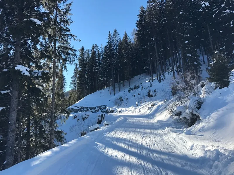
- Winter Sports: Outside the hiking season, Davos is a world-class destination for skiing, snowboarding, and cross-country skiing, with extensive slopes and facilities.
Safety and Conditions
Weather: Mountain weather can change rapidly. Always check the local forecast before setting out and be prepared for rain, wind, and temperature drops, even in summer. Hypothermia is a risk at higher altitudes.
Navigation: Trails are generally well-marked, but carrying a map, compass, and GPS device or smartphone with offline maps is essential. Fog can descend quickly, reducing visibility to near zero.
Terrain: The trail involves ascents and descents over varied terrain, including rocky paths, scree slopes, and alpine meadows. Sturdy hiking boots and trekking poles are highly recommended for stability and to reduce impact on joints.
Altitude: While not extremely high, the trail reaches elevations where altitude can affect some individuals. Stay hydrated and be aware of symptoms of altitude sickness.
Water Sources: Water is generally plentiful from streams and springs, but it is advisable to treat all water (filter or use purification tablets) to avoid gastrointestinal issues.
Emergency Contacts: In case of emergency, dial 144 for medical assistance or 112 for general emergency services in Switzerland. Consider carrying a personal locator beacon (PLB) for remote areas.
Communication: Mobile phone reception can be intermittent in mountainous areas. Inform someone of your hiking plans and expected return time.
Wildlife: While large predators are rare, be aware of local wildlife. Respect their space and do not feed animals.
Insurance: Ensure you have adequate travel insurance that covers hiking and potential medical evacuation.
Side Trips and Points of Interest
Jakobshorn Summit: The starting point for many itineraries, the summit of Jakobshorn offers immediate, expansive 360-degree views of the surrounding mountain ranges, including the Davos Klosters region and beyond. It's an excellent spot for initial orientation and photography.
Sertig Valley: This exceptionally beautiful valley is a highlight, known for its traditional Walser houses, charming chapel, and dramatic mountain backdrop. It feels like stepping back in time and offers a peaceful contrast to the higher alpine terrain.
Rinerhorn: If utilising the Rinerhorn cable car, the area offers further hiking opportunities and panoramic views, often exploring different valleys and ridges than those accessed from Jakobshorn.
Alpine Lakes: Various small alpine lakes (tarns) are often encountered along the route, reflecting the surrounding peaks and adding to the scenic beauty. These are perfect spots for a rest and a picnic.
Mountain Restaurants (Berggasthaus): Many points along the trail feature traditional mountain restaurants offering local cuisine and refreshments. These are not only places to refuel but also offer opportunities to experience Swiss alpine hospitality and enjoy the views from a comfortable setting.
Kirchner Museum Davos: While not directly on the trail, a visit to this museum in Davos town provides a cultural counterpoint to the natural beauty, showcasing the work of Ernst Ludwig Kirchner, who was inspired by the alpine landscape.
Leave No Trace
The principles of Leave No Trace are paramount when hiking in the pristine alpine environment of Davos. These guidelines help preserve the natural beauty and ecological integrity of the mountains for future generations.
- Plan Ahead and Prepare: Familiarise yourself with trail conditions, weather forecasts, and any local regulations. Pack appropriately for the conditions.
- Travel and Camp on Durable Surfaces: Stick to marked trails to avoid damaging fragile alpine vegetation. Avoid creating new paths. If camping is permitted in designated areas (though less common on this specific route), use established sites.
- Dispose of Waste Properly: Pack out everything you pack in, including all food scraps, wrappers, and any other litter. Use designated toilet facilities in villages and huts. If no facilities are available, dig a cathole at least 60 metres away from water sources, trails, and campsites.
- Leave What You Find: Do not remove or disturb natural objects such as rocks, plants, or flowers. Take only photographs and memories.
- Minimise Campfire Impacts: Campfires are generally not permitted on hiking trails or in sensitive alpine areas. Use a portable stove for cooking.
- Respect Wildlife: Observe wildlife from a distance. Never feed animals, as it can disrupt their natural behaviours and diets.
- Be Considerate of Other Visitors: Keep noise levels down, yield to other hikers, and maintain a respectful attitude towards fellow travellers and local residents.
By adhering to these principles, you contribute to the preservation of the stunning alpine landscapes you are privileged to explore.