The Panorama Trail (Banff) - A Window into the Heart of the Canadian Rockies
The Panorama Trail in Banff National Park is a quintessential Canadian Rockies experience, offering a condensed yet spectacular journey through some of the most iconic landscapes in North America. Situated high above the turquoise waters of Lake Louise, this 11.6-kilometre circuit provides hikers with an unparalleled vantage point of the Victoria Glacier, the surrounding six glaciers, and the jagged peaks of the Bow Valley. Unlike the more crowded lakeshore paths, the Panorama Trail ascends into the subalpine and alpine zones, where the air is crisp, the vistas are vast, and the geological history of the continent is written in the sheer limestone faces of the surrounding mountains. This is a moderate day walk that rewards a relatively modest elevation gain of 520 metres with views that are typically reserved for technical mountaineers.
- Distance: 11.6 km (loop/circuit)
- Duration: 4–6 hours
- Elevation Gain: 520 m
- Difficulty: Moderate
- Best Time: July to September (snow-free window)
- Highest Point: Approximately 2,250 m
- Closest City: Banff, Alberta (approx. 57 km)
- Trailhead: Lake Louise shoreline/Upper Lake Louise parking area
Overview
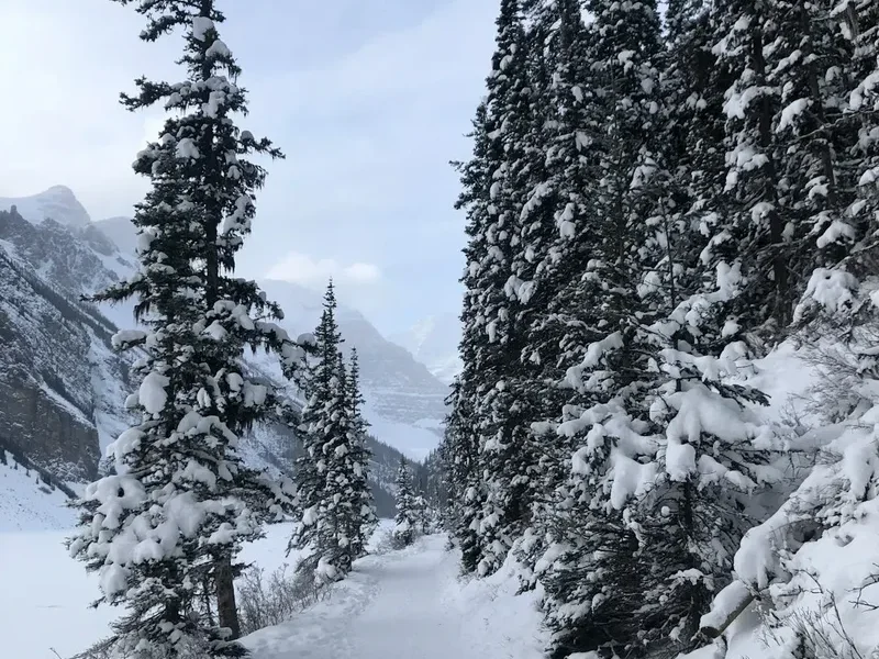
The Panorama Trail is often described as the "greatest hits" of the Lake Louise area. It manages to weave together the serene beauty of subalpine forests, the historical charm of mountain teahouses, and the raw, intimidating power of the high alpine environment. The trail is not a single named path in the traditional sense but a carefully curated combination of the Lake Agnes, Big Beehive, and Highline trails, creating a comprehensive loop that ensures hikers never see the same view twice. The journey begins at the world-famous Lake Louise, where the water's impossible turquoise hue—caused by "rock flour" or glacial silt suspended in the water—serves as a constant reference point as you ascend.
As you climb, the forest of Engelmann spruce and subalpine fir begins to thin, revealing glimpses of the Fairmont Chateau Lake Louise, which looks increasingly like a miniature toy castle against the immensity of the landscape. The trail's character changes as you reach Mirror Lake, a small, circular tarn sitting at the base of the Big Beehive, a massive thumb-shaped rock formation. From here, the ascent continues to Lake Agnes, where a historic teahouse has served hikers since 1905. This section of the walk is steeped in the "Golden Age" of Canadian mountaineering, reflecting a time when Swiss guides were brought to the Rockies to lead Victorian-era tourists into the wild.
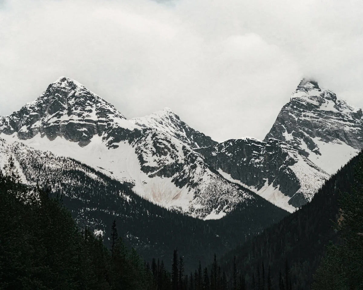
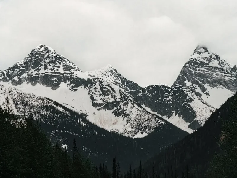
The true "panorama" begins once you leave the teahouse and climb the switchbacks to the summit of the Big Beehive. From this lofty perch, the view extends across the entire Bow Valley. To the west, the Victoria Glacier clings to the north face of Mount Victoria, its ancient ice groaning and occasionally calving with a sound like distant thunder. To the south, the peaks of the Valley of the Ten Peaks rise in a jagged line. The descent via the Highline Trail offers a different perspective, traversing across the mountain face through meadows of wildflowers—Indian paintbrush, heather, and western anemone—before reconnecting with the Plain of Six Glaciers trail. This is a landscape defined by the slow, relentless movement of ice and the enduring resilience of alpine life.
History and Cultural Context
The history of the Panorama Trail and the Lake Louise area is a complex tapestry of Indigenous heritage, colonial exploration, and the birth of Canadian tourism. For thousands of years before European arrival, the Stoney Nakoda (Iyethka) people inhabited and travelled through these valleys. They called Lake Louise "Ho-run-num-nay" (The Lake of Little Fishes). The area was a vital part of their traditional territory, used for hunting, gathering, and spiritual practices. The mountains were not merely scenery but living entities with deep cultural and spiritual significance. Today, Parks Canada works to recognise this enduring connection, though the names on the maps—Louise, Victoria, Agnes—reflect the British colonial influence of the late 19th century.
The "discovery" of the lake by Europeans is credited to Tom Wilson, a guide for the Canadian Pacific Railway (CPR), who was led to the site by Stoney Nakoda guides in 1882. Wilson was stunned by the beauty of the lake and the glacier, and he quickly reported his findings to the CPR. Recognising the potential for tourism, the railway company began developing the area, building the first iteration of the Chateau Lake Louise. To cater to the growing interest in mountaineering, the CPR hired professional Swiss guides, such as Edward Feuz and Christian Häsler, who established many of the trails used today, including the routes that form the Panorama Trail. These guides brought European mountain culture to the Rockies, emphasizing safety, technical skill, and a deep respect for the alpine environment.
The Lake Agnes Teahouse, a central landmark on the Panorama Trail, was built by the CPR in 1901 and began serving tea in 1905. It was named after Lady Agnes Macdonald, the wife of Canada's first Prime Minister, who visited the lake in 1886. The teahouse remains a family-run operation, and its presence is a testament to the long-standing tradition of mountain hospitality in Banff National Park. Walking this trail is not just a physical exercise; it is a journey through the history of how we have interacted with the wild—from the sustainable stewardship of the Stoney Nakoda to the adventurous spirit of the Swiss guides and the modern conservation efforts of Parks Canada.
Want more background? Read extended notes on history and cultural context → Learn more
Seasonal Highlights and Weather Reality
The window for hiking the Panorama Trail is relatively narrow due to its elevation and the heavy snowfall characteristic of the Canadian Rockies. While the lower sections near the lake may be accessible in late spring, the upper portions of the trail, particularly the switchbacks to the Big Beehive and the Highline section, often remain buried under snow until late June or early July. Attempting the trail before the snow has melted can be dangerous, as steep sections become slippery and the risk of avalanches from the surrounding peaks remains a reality well into the spring.
Summer (July to August): This is the peak season. The trails are generally clear of snow, the wildflowers are in full bloom, and the teahouses are fully operational. Daytime temperatures typically range from 15°C to 25°C, though it can feel much hotter in the direct sun at high altitudes. However, summer also brings the risk of afternoon thunderstorms. These storms can develop rapidly, bringing lightning, heavy rain, and sudden temperature drops. Hikers should aim to be off the highest points of the trail by early afternoon.
Autumn (September to early October): Many locals consider this the best time to hike. The air is crisper, the crowds have thinned, and the subalpine larch trees (Larix lyallii) begin their spectacular transformation. Unlike other conifers, larches turn a brilliant golden yellow before shedding their needles. While the Panorama Trail is not as famous for larches as the nearby Larch Valley, there are still pockets of gold to be found. Be aware that snow can fall at any time in September, and the teahouses usually close for the season by late September or early October.
Winter and Spring (November to June): During these months, the Panorama Trail is considered an alpine winter route. It requires specialized equipment (snowshoes, ice cleats, or touring skis) and, more importantly, advanced knowledge of avalanche terrain. Many sections of the trail cross known avalanche paths. For the average hiker, this trail is strictly a summer and autumn endeavour. Always check the Parks Canada trail report before heading out, as conditions can change overnight.
Recommended Itinerary
The Panorama Circuit Itinerary
Early Morning: The Ascent to Mirror Lake
- Start: Lake Louise Shoreline (1,731 m)
- Distance: 2.6 km
- Time: 45–60 minutes
- Begin at the paved path in front of the Fairmont Chateau Lake Louise.
- Follow the signs for Lake Agnes. The trail is a wide, well-maintained gravel path that climbs steadily through a forest of spruce and fir.
- Arrive at Mirror Lake, a perfect spot for a short break. The lake sits directly beneath the towering face of the Big Beehive.
- Look for the "Big Beehive" reflection in the still morning water.
Morning: Lake Agnes and the Teahouse
- Distance: 0.8 km from Mirror Lake
- Time: 20–30 minutes
- Continue climbing from Mirror Lake. You will pass a small waterfall just before reaching the wooden stairs that lead to the teahouse.
- Arrive at Lake Agnes (2,135 m). The teahouse offers tea, coffee, and fresh baked goods (cash is preferred).
- Take time to walk around the shore of Lake Agnes, which is cradled in a spectacular hanging valley.
- The peaks of Mount Whyte and Mount Niblock tower over the far end of the lake.
Midday: The Big Beehive Summit
- Distance: 1.6 km from Lake Agnes
- Elevation Gain: 140 m
- Time: 45–60 minutes
- Follow the trail around the right side of Lake Agnes.
- Begin the steep switchbacks that climb the back of the Big Beehive. This is the most strenuous part of the hike.
- Reach the summit ridge and follow it to the wooden gazebo at the end.
- Enjoy the "Panorama"—a 360-degree view of Lake Louise, the Victoria Glacier, and the surrounding peaks. This is the highest point of the circuit.
Afternoon: The Highline Trail and Descent
- Distance: 6.6 km (return to Lake Louise)
- Time: 2–2.5 hours
- From the Big Beehive summit, descend back to the junction but instead of returning to Lake Agnes, follow the signs for the Highline Trail.
- The Highline Trail traverses the mountain face, offering constant views of the Victoria Glacier.
- Pass through alpine meadows and rock slides (watch for pikas and marmots).
- The trail eventually joins the Plain of Six Glaciers trail. Turn left to head back towards the lake.
- The final 4 km is a gentle descent along the shoreline of Lake Louise, providing a relaxing finish to the day.
Important Notes:
- Start early (before 8:00 AM) to secure parking and avoid the largest crowds.
- The teahouse can have long queues; if you plan to eat there, factor in extra time.
- Carry bear spray and know how to use it—this is prime grizzly bear habitat.
- The weather at the Big Beehive summit is often much windier and colder than at the lakeshore.
Planning and Bookings
Book Your Trip
Everything you need to plan your journey
Accommodation
Find places to stay near Banff
Flights
Search flights to Banff
Essential Preparation
The Panorama Trail is a moderate hike, but it requires a reasonable level of cardiovascular fitness due to the steady elevation gain and the altitude. At over 2,000 metres, the air is thinner than at sea level, which can make the climb feel more taxing. It is highly recommended to spend at least one day in Banff or Lake Louise village (approx. 1,600 m) to acclimatise before attempting the higher trails.
Logistics are the biggest challenge in the Lake Louise area. Parking at the upper lake is extremely limited and often fills up by 6:30 AM during the summer months. Parks Canada now operates a mandatory shuttle system for those who cannot secure parking. You must book your shuttle seats in advance through the Parks Canada website. Alternatively, Roam Public Transit offers service from the town of Banff to Lake Louise, which is a convenient and environmentally friendly option. Ensure you have downloaded offline maps (such as AllTrails or Gaia GPS), as mobile signal is spotty once you leave the lakeshore.
Trail Accommodation
This is a day hike requiring no overnight accommodation on the trail itself. Camping is strictly prohibited along the Panorama Trail and around Lake Agnes to protect the fragile alpine environment and prevent human-wildlife conflict.
Nearby Options:
- Lake Louise Campground: Located in the valley floor, offering both tent and RV sites. It features hot showers, flush toilets, and a heavy-duty electric fence to keep bears out. Bookings are essential and open in early spring.
- Fairmont Chateau Lake Louise: For those seeking luxury, the hotel sits directly at the trailhead. It offers world-class amenities but requires booking many months in advance.
- HI Lake Louise Alpine Centre: A high-end hostel offering both dorms and private rooms, located in the village. It is a popular base for hikers and climbers.
- Backcountry Huts: While not on this trail, the Abbot Pass Hut was historically a nearby option, but it has unfortunately been decommissioned due to slope instability. The nearest backcountry hut is the Elizabeth Parker Hut at Lake O'Hara, which requires a separate lottery-based booking system.
Required Gear
- Hiking Boots: Sturdy, waterproof boots with good ankle support are essential. The trail involves rocky sections and potential mud.
- Layered Clothing: A moisture-wicking base layer, an insulating mid-layer (fleece or down), and a waterproof/windproof outer shell. Temperatures can drop 10°C between the lake and the summit.
- Bear Spray: Non-negotiable. Carry it in a holster on your hip or chest strap, not inside your pack. Ensure you know how to remove the safety clip and fire it.
- Sun Protection: High-altitude sun is intense. Bring a hat, sunglasses with UV protection, and SPF 50+ sunscreen.
- Trekking Poles: Highly recommended for the steep switchbacks on the Big Beehive and the descent on the Highline Trail to save your knees.
- First Aid Kit: Include blister pads (moleskin), antiseptic wipes, and any personal medications.
What to Bring
- Water: At least 2 litres per person. Do not drink from the lakes or streams without treatment (filter or tablets) due to the risk of Giardia.
- Food: High-energy snacks (nuts, dried fruit, chocolate) and a substantial lunch. While the teahouse has food, it should be treated as a treat rather than a primary meal source in case it is closed or sold out.
- Cash: The Lake Agnes Teahouse accepts credit cards but often has a surcharge or the machine may fail due to poor connectivity. Canadian cash is the most reliable payment method.
- Emergency Whistle: Often built into the chest strap of modern hiking packs.
- Headlamp: Even if you plan to be back by afternoon, always carry a light source in case of an unexpected delay.
- Trash Bag: To pack out all your waste, including fruit peels and tissues.
Permits
To hike the Panorama Trail, you do not need a specific backcountry permit, as it is a day-use area. However, you are required to have a valid Parks Canada Discovery Pass or a daily entry permit to enter Banff National Park. This pass must be displayed on your vehicle's dashboard or held by the individual if arriving by public transport.
Pass Options and Costs (2024/2025 rates):
- Daily Pass: Approximately $11.00 per adult, $9.50 per senior, or $22.00 per family/group. This is valid until 4:00 PM the following day.
- Discovery Pass (Annual): Approximately $75.00 per adult or $151.00 per family/group. This provides access to over 80 national parks and historic sites across Canada for a full year. If you plan to spend more than seven days in the national parks, the annual pass is more cost-effective.
Shuttle Bookings:
While not a "permit" in the legal sense, a shuttle reservation is practically mandatory for most visitors. Parks Canada releases 40% of shuttle seats in the spring (usually late March) and the remaining 60% on a rolling basis 48 hours before the departure date at 8:00 AM MST. These seats sell out within seconds. If you fail to secure a shuttle or a parking spot, you will not be able to access the trailhead.
Commercial Groups: If you are leading an organised group or a commercial tour, you must obtain a separate business licence and group permit from the Banff National Park administration office.
Other Activities in the Area
Banff National Park is a vast playground. If you have extra time in the Lake Louise area, consider these activities:
- Canoeing on Lake Louise: Rent a classic red canoe from the boathouse. It is expensive, but paddling toward the Victoria Glacier provides a perspective you cannot get from the shore.
- Moraine Lake: Located in the nearby Valley of the Ten Peaks. Access is now restricted to shuttles and public transit only. The Rockpile Trail offers the famous "Twenty Dollar View."
- Plain of Six Glaciers Teahouse: If the Panorama Trail wasn't enough, you can extend your walk to this second teahouse, which sits even closer to the Victoria Glacier.
- Banff Gondola: Located in the town of Banff, this takes you to the summit of Sulphur Mountain for views of the townsite and the Bow River.
- Upper Hot Springs: A perfect way to soak sore muscles after a long hike. The natural mineral waters are kept at a relaxing 37–40°C.
- Icefields Parkway: Drive north from Lake Louise toward Jasper. This is widely considered one of the most scenic drives in the world, passing the Crowfoot Glacier and Bow Lake.
Safety and Conditions
Wildlife Safety (Bears): Banff National Park is home to both black bears and grizzly bears. The Lake Louise area is a critical corridor for grizzlies. To stay safe: make noise (talk, sing, or clap) to avoid surprising a bear, especially near rushing water or in dense brush; always carry bear spray in an accessible location; and never hike alone if possible. If you encounter a bear, stay calm, do not run, and back away slowly while speaking in a low, firm voice.
Weather and Hypothermia: Weather in the Rockies is notoriously unpredictable. A sunny morning can turn into a freezing sleet storm by noon. Hypothermia is a genuine risk even in summer if you get wet and the wind picks up at the Big Beehive summit. Always carry a waterproof shell and an extra warm layer. If you see dark clouds building or hear thunder, descend from the ridges immediately.
Terrain Hazards: The trail is well-maintained, but it is still a mountain environment. The switchbacks to the Big Beehive are steep and can be slippery if wet. Stay on the marked trail; taking shortcuts on switchbacks causes erosion and can lead to rockfalls that endanger hikers below. The Highline Trail crosses several scree slopes (loose rock); watch your footing and be mindful of other hikers.
Altitude Sickness: While 2,250 m is not extreme, some hikers may experience mild symptoms of altitude sickness, such as headaches, nausea, or dizziness. If you feel unwell, stop, hydrate, and if symptoms persist, descend to a lower elevation. The best prevention is to drink plenty of water and avoid overexertion on your first day in the park.
Emergency Contact: In case of a serious emergency, call 911. However, be aware that mobile reception is non-existent on many parts of the trail. Carrying a satellite communication device (like a Garmin inReach or Zoleo) is a wise precaution for solo hikers or those heading into more remote sections.
Side Trips and Points of Interest
The Little Beehive: A shorter, slightly easier alternative or addition to the Big Beehive. The trail branches off near Lake Agnes and leads to a viewpoint overlooking the Bow Valley and the ski resort. It offers a different angle of the lake and is often slightly less crowded than its "big" brother.
Mount St. Piran: For those with extra energy and experience, the trail to Mount St. Piran branches off from the Little Beehive path. This is a more strenuous ascent to a true mountain summit (2,435 m). It requires an additional 2–3 hours and offers a 360-degree view that includes the Skoki Valley to the north. The trail is steeper and more rugged than the main Panorama circuit.
The Devil's Thumb: This is an unofficial, unmaintained scramble that branches off from the Big Beehive switchbacks. It leads to a spectacular viewpoint where you can see both Lake Agnes and Lake Louise simultaneously. Warning: This route involves steep, loose scree and some exposure. It is only recommended for experienced hikers with good boots and a steady head for heights. It is not part of the official Parks Canada trail system.
Plain of Six Glaciers Lookout: If you descend via the Highline Trail, you can take a short detour toward the Victoria Glacier lookout. This brings you to the edge of the lateral moraine, where you can look directly down onto the debris-covered ice of the glacier. The scale of the ice and the surrounding peaks (Mount Lefroy and Mount Victoria) is truly humbling from this vantage point.
Leave No Trace
Banff National Park receives millions of visitors every year. To preserve the beauty and ecological integrity of the Panorama Trail, all hikers must adhere to the Leave No Trace principles. The alpine environment is extremely fragile; a single footstep off-trail can destroy plants that have taken years to grow in the short mountain growing season.
Core Principles for the Panorama Trail:
- Plan Ahead and Prepare: Know the weather, have the right gear, and ensure you have your shuttle or parking sorted.
- Travel on Durable Surfaces: Stay on the established trail. Do not cut switchbacks, as this causes severe erosion and destroys the trail's stability.
- Dispose of Waste Properly: Pack out everything. This includes "natural" waste like banana peels, orange rinds, and apple cores, which do not decompose quickly in the cold alpine climate and can attract bears to the trail.
- Leave What You Find: Do not pick wildflowers, and leave rocks and fossils where they are. It is illegal to remove any natural objects from a National Park.
- Respect Wildlife: Observe animals from a distance. Never feed wildlife, including the "begging" ground squirrels and grey jays at the teahouse. Human food makes them sick and dependent, and "a fed bear is a dead bear."
- Be Considerate of Others: Keep noise levels down. Yield to uphill hikers. If you are using trekking poles, ensure they have rubber tips to reduce noise and trail scarring.