Panorama Ridge - The Crown Jewel of Garibaldi Provincial Park
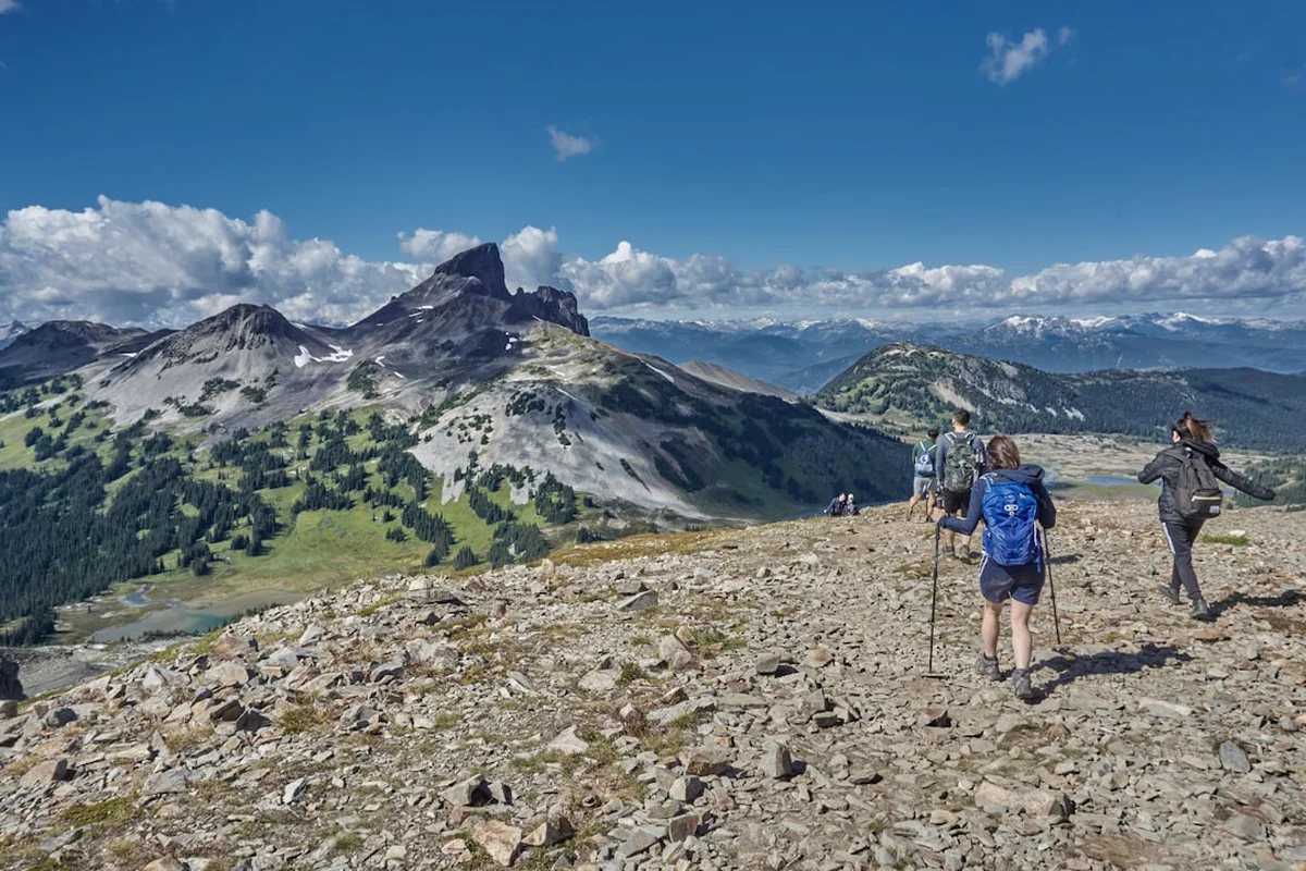
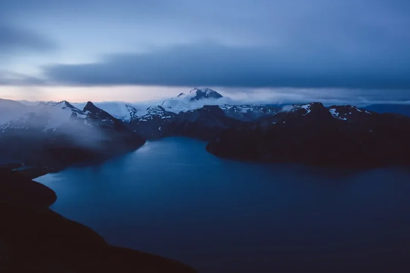
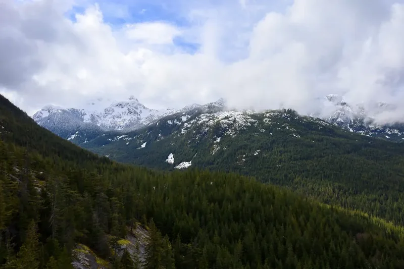
Panorama Ridge is widely considered the most spectacular day hike in British Columbia, Canada. Located within the rugged heart of Garibaldi Provincial Park, this 29-kilometre round-trip journey offers a visual reward that few trails on Earth can match. The hike culminates at a high alpine ridge that provides a 360-degree perspective of the Coast Mountains, including the iconic volcanic spire of the Black Tusk, the sprawling Helm Glacier, and the impossibly turquoise waters of Garibaldi Lake sitting 1,000 metres below the summit. This is a journey through diverse ecosystems, beginning in dense, ancient forests of Douglas fir and Western Red Cedar, ascending through sub-alpine meadows filled with seasonal wildflowers, and finishing in a stark, rocky alpine environment where snow lingers well into the summer months.
The trail is a testament to the raw power of volcanic activity and glaciation. Every step of the 1,450-metre elevation gain reveals a new layer of geological history, from the massive lava dam known as "The Barrier" to the jagged peaks that define the horizon. While the distance and elevation make this a challenging endeavour for even experienced hikers, the well-maintained trail and the sheer scale of the scenery attract thousands of adventurers every year. It is a hike that demands physical stamina, careful planning, and a deep respect for the unpredictable mountain weather of the Pacific Northwest. For those who reach the ridge, the experience is often described as transformative—a moment of profound connection with one of the world's most pristine wilderness areas.
- Distance: 29.0 km return
- Elevation Gain: 1,450 m
- Duration: 10–12 hours
- Difficulty: Challenging
- Best Time: July to September
- Closest City: Whistler, BC
- Trailhead: Rubble Creek Parking Lot
- Highest Point: 2,133 m
Overview
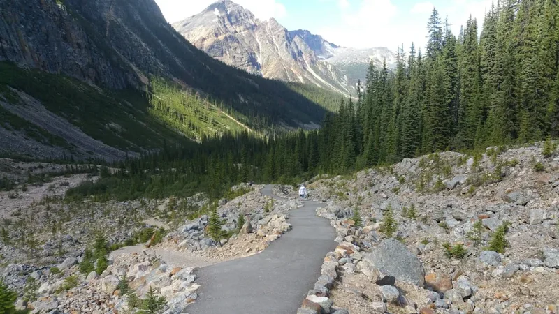
The Panorama Ridge trail is a masterclass in landscape progression. The journey begins at the Rubble Creek trailhead, situated at an elevation of approximately 580 metres. The first six kilometres of the hike are often described as a "mental game," consisting of a relentless series of switchbacks through a dense, second-growth forest. While this section lacks the dramatic views found later in the day, it serves as a necessary gateway, testing the legs and lungs of hikers as they climb steadily away from the valley floor. The air is thick with the scent of pine and damp earth, and the sound of Rubble Creek provides a constant, rushing soundtrack to the initial ascent.
As you reach the 6-kilometre mark, the trail splits, offering two distinct routes toward the ridge: one via Taylor Meadows and the other via Garibaldi Lake. Most hikers choose to ascend through Taylor Meadows to experience the vibrant displays of sub-alpine wildflowers—lupines, Indian paintbrush, and heather—that carpet the landscape in late July and August. This section of the trail levels out significantly, providing a much-needed reprieve for the legs. The forest thins, replaced by clusters of sub-alpine fir and mountain hemlock, and the first glimpses of the Black Tusk begin to appear, its dark, jagged silhouette dominating the skyline to the north.
The final three kilometres of the ascent are where the true challenge begins. Leaving the meadows behind, the trail enters a world of rock and ice. The path becomes steeper and more technical, requiring hikers to navigate over loose scree and occasional snow patches. The final scramble to the summit of the ridge is physically demanding, but as the horizon expands, the fatigue begins to fade. Upon reaching the crest, the full majesty of Garibaldi Provincial Park is revealed. The view of Garibaldi Lake is the undisputed highlight; the water's intense turquoise colour, caused by "glacial flour" (fine rock particles suspended in the water), creates a surreal contrast against the surrounding grey granite and white glaciers. To the south, Mount Garibaldi (2,678 m) stands as a silent sentinel, while to the east, the Helm Glacier stretches toward the horizon. The ridge itself is wide and spacious, allowing hikers to find a quiet spot to sit, refuel, and absorb a panorama that feels truly infinite.
History and Cultural Context
The land encompassing Panorama Ridge and Garibaldi Provincial Park is the traditional, ancestral, and unceded territory of the Skwxwú7mesh (Squamish) and Lil̓wat7úl (Lil'wat) Nations. For thousands of years, these Indigenous peoples have lived in harmony with this landscape, using the valleys and mountains for hunting, gathering, and spiritual practices. The Black Tusk, known as "t'ak't'ak mu'yin tl'a in7in'a'xe7en" in the Squamish language, holds significant cultural and spiritual importance, often associated with the Thunderbird, a powerful supernatural being in Indigenous oral histories. Recognising the deep connection these Nations have to the land is an essential part of the modern hiking experience, reminding visitors that they are guests in a landscape with a rich and enduring human history.
The geological history of the area is equally fascinating. The landscape was shaped by intense volcanic activity during the Pleistocene epoch. Approximately 9,000 to 13,000 years ago, lava flows from Mount Price and Clinker Peak were blocked by a massive wall of glacial ice in the Cheakamus Valley. As the lava cooled against the ice, it formed a vertical cliff of volcanic rock known as "The Barrier." This 300-metre-thick lava dam is what created Garibaldi Lake, trapping the meltwater from the surrounding glaciers. The Barrier remains geologically unstable; in 1855, a massive rockfall occurred, creating the debris field that gives Rubble Creek its name. Today, the area is strictly monitored, and camping is prohibited directly below The Barrier due to the ongoing risk of landslides.
Garibaldi Provincial Park was officially established in 1927, following years of advocacy by early mountaineers and naturalists who recognised the area's exceptional beauty. In the early 20th century, the park was primarily the domain of rugged explorers and members of the British Columbia Mountaineering Club. It wasn't until the construction of the Sea to Sky Highway and the development of Whistler as a world-class resort that the trail to Panorama Ridge became accessible to the broader public. Today, the park covers over 1,950 square kilometres and serves as a vital sanctuary for wildlife and a premier destination for outdoor recreation in North America.
Want more background? Read extended notes on history and cultural context → Learn more
Seasonal Highlights and Weather Reality
The window for hiking Panorama Ridge is relatively short, typically spanning from July to September. Because of its high elevation, the ridge remains covered in snow long after the valleys have turned green. Attempting the hike in June often involves navigating deep, soft snow, which can make the 29-kilometre journey significantly more exhausting and increase the risk of post-holing or losing the trail.
Summer (July to August): This is the peak season for Panorama Ridge. By mid-July, the snow has usually melted from the meadows, giving way to a spectacular explosion of wildflowers. This is also the best time to see Garibaldi Lake at its most vibrant turquoise, as the summer melt increases the concentration of glacial flour. However, summer also brings the largest crowds and the presence of biting insects, particularly mosquitoes and blackflies in the meadow sections. Hikers should be prepared for intense sun exposure on the ridge, where there is no shade.
Autumn (September to early October): Many experienced hikers consider September to be the finest month for the ridge. The crowds begin to thin, the bugs disappear, and the air becomes crisp and clear, offering the best visibility for photography. The sub-alpine shrubs turn brilliant shades of red and gold, creating a stunning contrast with the blue of the lake. However, the days are shorter, and the temperature on the ridge can drop below freezing, even if it is warm at the trailhead. Early season snowfalls can occur as early as mid-September, requiring hikers to carry extra layers and traction devices.
Winter and Spring (November to June): During the winter months, Panorama Ridge transforms into a serious backcountry ski touring or snowshoeing objective. This requires advanced navigation skills, avalanche safety training (AST-1 at a minimum), and specialised equipment. The trail is not marked for winter use, and the risk of avalanches on the final slopes of the ridge is significant. For the average hiker, the trail is considered inaccessible during this period.
Recommended Itinerary
Panorama Ridge Day Hike Itinerary
Early Morning: The Forest Ascent (06:00 – 08:30)
- Start at Rubble Creek Trailhead (580 m elevation).
- Begin the 6-kilometre climb through the switchbacks.
- Maintain a steady, sustainable pace; this is the most monotonous part of the day.
- Pass the 6-km junction. Follow signs toward Taylor Meadows.
- The gradient begins to ease as you enter the sub-alpine zone.
Mid-Morning: Taylor Meadows (08:30 – 10:30)
- Walk through the rolling terrain of Taylor Meadows.
- Enjoy the wildflowers (July/August) and the first clear views of the Black Tusk.
- Pass the Taylor Meadows campground (toilets available here).
- Continue toward the junction for Panorama Ridge and Black Tusk.
- Fill up water at the small streams in the meadows (must be treated).
Late Morning: The Final Ascent (10:30 – 12:30)
- Leave the meadows and begin the rocky climb toward the ridge.
- The trail becomes steeper and more rugged, with loose rock (scree).
- Follow the orange markers and well-worn path through the boulder fields.
- Navigate any remaining snow patches carefully.
- The final 1.5 km involves a significant elevation gain over technical terrain.
Midday: The Summit (12:30 – 13:30)
- Arrive at the crest of Panorama Ridge (2,133 m).
- Take time to explore the ridge; the best views of Garibaldi Lake are from the southern edge.
- Refuel with a high-calorie lunch and hydrate.
- Photograph the 360-degree views of the Black Tusk, Helm Glacier, and Mount Garibaldi.
- Be mindful of the time; the descent is long and requires focus.
Afternoon: The Descent (13:30 – 18:00)
- Begin the descent back down the rocky ridge. Use caution on the loose scree.
- At the junction, you can choose to return via Garibaldi Lake for a change of scenery (adds approx. 1.5 km).
- If returning via the lake, enjoy a quick (and very cold) dip or a rest by the shore.
- Re-enter the forest switchbacks for the final 6 km. This section is often the hardest on the knees.
- Arrive back at Rubble Creek trailhead.
Important Notes:
- Total moving time is typically 8–10 hours, but allow 12 hours for breaks and photography.
- Start as early as possible (before 07:00) to secure parking and avoid the midday heat.
- The descent via Garibaldi Lake is highly recommended for the scenery, though it involves a short uphill section to get back to the main trail.
- Always check the BC Parks website for trail closures or bear activity before starting.
Planning and Bookings
Book Your Trip
Everything you need to plan your journey
Accommodation
Find places to stay near Whistler
Flights
Search flights to Whistler
Essential Preparation
Preparation for Panorama Ridge begins weeks before you set foot on the trail. Given the 29-kilometre distance, a high level of cardiovascular fitness is required. If you are not accustomed to long days in the mountains, consider doing several shorter hikes with significant elevation gain (800 m+) in the weeks leading up to your trip. Logistics are also a major factor; the Rubble Creek trailhead is a 2.5-hour drive from Vancouver and a 30-minute drive from Whistler. The parking lot is notorious for filling up by 07:00 on summer weekends, so an early start is non-negotiable.
Whistler serves as the best base for this hike. It offers a wide range of accommodation, from luxury hotels to hostels, and has numerous outdoor retailers where you can rent gear or buy bear spray. Ensure your vehicle is in good working order, as the road to the trailhead is paved but steep. There is no mobile phone reception at the trailhead or for most of the hike, so download your maps for offline use and leave a detailed trip plan with a trusted person.
Trail Accommodation
While Panorama Ridge is frequently completed as a day hike, many people choose to break it into two days by camping. There is no accommodation on the ridge itself; camping is strictly limited to designated campgrounds to protect the fragile alpine environment.
Garibaldi Lake Campground:
- Located 9 km from the trailhead.
- 50 tent pads, pit toilets, and four day-use shelters for cooking.
- Food must be stored in the provided bear-proof lockers.
- No running water (lake water must be treated).
- Cost: CAD$10 per person, per night.
Taylor Meadows Campground:
- Located 7.5 km from the trailhead.
- 40 tent pads, pit toilets, and a small day-use shelter.
- Often preferred by those heading to the ridge as it is slightly closer than the lake.
- Beautiful meadow setting, but more exposed to wind than the lake.
- Cost: CAD$10 per person, per night.
Booking Requirements:
- Reservations are mandatory for all overnight stays year-round.
- Bookings can be made through the BC Parks reservation system up to four months in advance.
- During the summer, weekend spots sell out within minutes of being released.
- No walk-in camping is permitted; rangers frequently check permits.
Required Gear
- Hiking Boots: Sturdy, waterproof boots with good ankle support are essential for the rocky terrain and scree slopes.
- Clothing Layers: A moisture-wicking base layer, an insulating mid-layer (fleece or down), and a high-quality waterproof shell. The temperature on the ridge can be 10–15°C cooler than the trailhead.
- Navigation: A physical map and compass, or a GPS device/offline map app (e.g., AllTrails or Gaia GPS) with extra battery power.
- Sun Protection: High-SPF sunscreen, polarized sunglasses, and a wide-brimmed hat. The reflection from snow and rock is intense.
- Headlamp: Essential even if you plan to be back before dark. Delays are common, and the forest switchbacks are pitch black at night.
- Bear Spray: This is grizzly and black bear country. Carry bear spray in an accessible holster (not inside your pack) and know how to use it.
- First Aid Kit: Include blister pads (moleskin), antiseptic wipes, bandages, and any personal medications.
- Emergency Shelter: A lightweight emergency bivy or space blanket.
What to Bring
- Water: At least 3 litres per person. There are no water sources on the ridge itself. You can refill at Taylor Meadows or Garibaldi Lake, but the water MUST be treated (filter, tablets, or boiling).
- Food: High-calorie, nutrient-dense meals and snacks. Think nuts, dried fruit, energy bars, and a substantial lunch for the summit. You will burn 3,000–5,000 calories on this hike.
- Electrolytes: Salt tablets or electrolyte powder to add to your water, especially on hot days.
- Toiletries: Small amount of toilet paper and a sealable bag to pack it out. Hand sanitiser is essential.
- Traction Devices: Micro-spikes are highly recommended if hiking in July or late September when snow and ice are likely.
- Trekking Poles: Highly recommended to save your knees on the 1,450-metre descent.
Permits
To manage the high volume of visitors and protect the ecological integrity of Garibaldi Provincial Park, BC Parks has implemented a Day-use Pass system. This is separate from camping reservations and is required for all visitors accessing the Rubble Creek trailhead during the peak season (typically mid-June to mid-October).
Day-use Pass Details:
- Passes are free of charge but mandatory.
- They must be booked online through the BC Parks website.
- Passes become available at 7:00 AM local time, two days prior to your planned visit.
- They sell out extremely quickly, often within minutes for weekend dates.
- You must have a digital or printed copy of your pass to show park rangers at the trailhead.
- One pass is required per vehicle, or per person if arriving by transit/shuttle.
Camping Permits: If you are staying overnight, your camping reservation acts as your day-use pass. You do not need to book both. Ensure you have your camping permit printed, as there is no cell service at the trailhead to download it. Rangers are active in the park and will ask to see your permit at the campgrounds or on the trail.
Commercial Groups: Any organised group, such as a hiking club or commercial tour, requires a separate Park Use Permit. Individual hikers do not need to worry about this, but if you are joining a guided trip, ensure the operator is legally permitted to work in the park.
Other Activities in the Area
The Sea to Sky corridor is a world-class destination for outdoor enthusiasts. If you have extra time in the area, consider these activities:
- Whistler Village: Explore the pedestrian-only village, which offers excellent dining, shopping, and a vibrant atmosphere.
- Peak 2 Peak Gondola: Experience the world's highest and longest unsupported cable car span, connecting Whistler and Blackcomb mountains.
- Squamish Adventure: Known as the "Outdoor Recreation Capital of Canada," Squamish offers world-class rock climbing on the Stawamus Chief and exceptional mountain biking trails.
- Sea to Sky Gondola: Located in Squamish, this gondola provides easy access to stunning views of Howe Sound and several alpine hiking trails.
- Brandywine Falls: A short, easy walk to a spectacular 70-metre waterfall located just off the highway between Squamish and Whistler.
- Scandinave Spa Whistler: The perfect place to recover after a 29-km hike, offering traditional Scandinavian baths and massages in a peaceful forest setting.
Safety and Conditions
Wildlife Safety: Garibaldi Provincial Park is home to both black bears and grizzly bears. While bears generally avoid humans, encounters are possible, especially in the berry-filled meadows. Always hike in groups, make noise (talk, sing, or clap) to avoid surprising a bear, and keep a clean camp if staying overnight. Never leave food unattended. If you encounter a bear, stay calm, do not run, and back away slowly while speaking in a low, firm voice. Carry bear spray in an accessible location and know how to deploy it.
Weather Hazards: Mountain weather is notoriously fickle. A sunny morning at the trailhead can turn into a freezing rainstorm or a whiteout on the ridge by afternoon. Hypothermia is a genuine risk, even in summer, if you are caught unprepared. Always check the mountain-specific forecast (such as Snow-Forecast or SpotWx) rather than the general Whistler town forecast. If clouds begin to build or the wind picks up significantly, do not hesitate to turn back. The ridge is highly exposed and is the last place you want to be during a lightning storm.
Terrain and Navigation: The final ascent to Panorama Ridge involves navigating steep, loose rock. This requires good balance and concentration. If you are hiking in early summer, be aware of "moats"—deep gaps that form between the snow and large rocks—which can be dangerous if you fall in. While the trail is generally well-marked with orange tags on trees and cairns (rock piles) in the alpine, fog can quickly obscure these markers. Always have a GPS backup and know how to use a compass.
Physical Exhaustion: The most common cause of injury on this trail is simple fatigue. The 1,450-metre descent is punishing on the joints, and many hikers trip or twist ankles in the final kilometres. Listen to your body, take regular breaks, and ensure you are consuming enough calories and electrolytes to maintain your energy levels. If you feel you have reached your limit at Taylor Meadows, there is no shame in turning back; the views from the meadows are still exceptional.
Side Trips and Points of Interest
The Black Tusk: For those with extra energy and time, the Black Tusk is a popular addition or alternative to Panorama Ridge. The trail branches off from the main path in Taylor Meadows. The final ascent to the "shoulder" of the Tusk provides incredible views, but the true summit requires a technical, high-exposure scramble up a loose chimney. This is not recommended for those without scrambling experience or helmets, as rockfall is a constant hazard.
Garibaldi Lake: If you didn't choose the lake route on your way up, it is highly recommended to visit on the way down. The shoreline offers several beautiful spots to rest, and the sight of the Battleship Islands and the Sphinx Glacier across the water is iconic. The water is glacially fed and extremely cold, but a quick "polar plunge" is a rite of passage for many hikers.
Helm Lake and Cinder Flats: If you are doing a multi-day trip, you can continue past Panorama Ridge toward the Helm Creek campground. This route takes you through the "Cinder Flats," a surreal, volcanic landscape of black sand and pumice that feels like walking on another planet. This area is much less crowded than the Rubble Creek side of the park.
Mimulus and Black Tusk Lakes: These small, alpine lakes are located in the meadows between Taylor Meadows and the Black Tusk. They are quieter than Garibaldi Lake and offer beautiful reflections of the surrounding peaks on calm days. They are perfect spots for a quiet break away from the main trail traffic.
Leave No Trace
Garibaldi Provincial Park is a fragile ecosystem that faces immense pressure from its popularity. Every visitor has a responsibility to minimise their impact to ensure the park remains pristine for future generations. The alpine environment is particularly sensitive; a single footstep off-trail can destroy heather or moss that has taken decades to grow.
The Seven Principles:
- Plan Ahead and Prepare: Ensure you have the fitness, gear, and permits required. Check weather and trail conditions.
- Travel and Camp on Durable Surfaces: Stay on the established trail at all times. In the meadows, do not walk abreast, as this widens the trail. Only camp in designated tent pads.
- Dispose of Waste Properly: Pack out EVERYTHING. This includes orange peels, nut shells, and used toilet paper. Use the pit toilets at the campgrounds; if you must go on the trail, dig a "cathole" 20 cm deep and at least 60 m from water sources.
- Leave What You Find: Do not pick wildflowers or remove rocks. Leave the landscape as you found it for others to enjoy.
- Minimise Campfire Impacts: Campfires are strictly prohibited throughout Garibaldi Provincial Park. Use a lightweight stove for cooking.
- Respect Wildlife: Observe animals from a distance. Never feed wildlife, including birds and squirrels, as this habituates them to humans and can lead to their death.
- Be Considerate of Others: Keep noise levels down. Yield to uphill hikers. Ensure your group size is small and manageable.