Pamir Mountain Desert Trek - Journey Through the Roof of the World
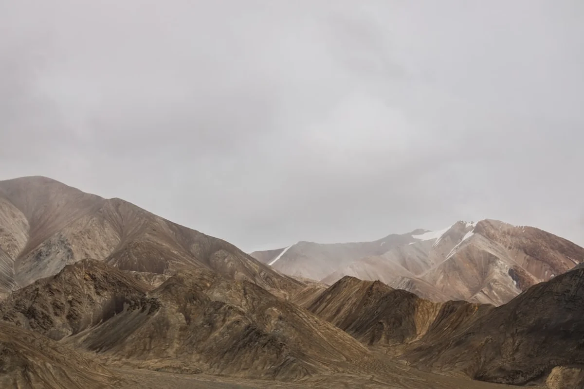
The Pamir Mountain Desert Trek is one of the most formidable and visually arresting high-altitude journeys on the planet. Spanning 200 kilometres across the Gorno-Badakhshan Autonomous Region (GBAO) of eastern Tajikistan, this route traverses the "Bam-i-Dunya" or "Roof of the World." Unlike the lush, forested valleys of the Himalayas or the Alps, the Pamir Plateau is a high-altitude cold desert—a landscape of stark, lunar beauty where cobalt-blue lakes sit in basins of rust-coloured rock, and 7,000-metre peaks shimmer on the horizon like white-capped waves. This is a trek of profound isolation, where the silence is broken only by the wind and the occasional whistle of a marmot. It is a journey that demands total self-sufficiency, physical resilience, and a deep respect for the raw power of the Central Asian wilderness.
- Distance: 200.0 km point-to-point
- Duration: 10–14 days
- Season: July–September (the only window where passes are clear and temperatures are manageable)
- Accommodation: Wild camping (mandatory self-sufficiency; occasional Kyrgyz yurt stays)
- Highest point: Various passes exceeding 4,800 metres
- Difficulty: Very Challenging (extreme altitude, total isolation, and unpredictable weather)
- Permits: GBAO permit and Tajik Visa required; additional Tajik National Park fees apply
- Direction: Generally North to South (Kyzyl-Art Pass to Murghab)
Overview
The Pamir Mountain Desert Trek is not merely a hike; it is an expedition into one of the least-visited corners of the globe. The Pamir Mountains form the hub of the great Asian mountain systems—the junction where the Hindu Kush, Karakoram, Kunlun, and Tian Shan ranges meet. The trek takes place primarily on the Eastern Pamir Plateau, an area characterised by wide, high-altitude valleys situated at an average elevation of 3,500 to 4,200 metres. This unique geography creates a "cold desert" ecosystem where precipitation is minimal, but the environment is shaped by extreme temperature fluctuations and intense solar radiation.
The aesthetic of the trek is defined by its scale. The valleys are so vast that a mountain range ten kilometres away can appear within arm's reach, and the sky feels lower and more intimate than anywhere else on Earth. Walkers will encounter the massive Karakul Lake—a 52-kilometre-wide impact crater formed by a meteorite millions of years ago—whose waters shift from turquoise to deep indigo depending on the angle of the sun. The route weaves through the Pshart and Madiyan valleys, crossing high passes that offer panoramic views of the Muztagh Ata and Kongur Tagh massifs in neighbouring China.
Logistically, the trek is a masterclass in remote travel. There are no permanent settlements between the start and end points, save for the seasonal yurts of semi-nomadic Kyrgyz herders who graze their yaks on the sparse alpine grasses. This lack of infrastructure means trekkers must carry all their own supplies or arrange for pack animals (donkeys or camels). The physical toll of the trek is significant; the thin air at 4,000 metres makes every kilometre feel like three, and the lack of shade means the sun is a constant, burning presence during the day, while temperatures can plummet below freezing the moment the sun dips behind the peaks. For those who seek the ultimate test of mountain endurance and the reward of absolute solitude, the Pamir Mountain Desert Trek is unparalleled.
History and Cultural Context
The Pamirs have served as a vital corridor for human movement for millennia. This region was a key segment of the ancient Silk Road, the network of trade routes that connected China with the Mediterranean. Caravans laden with silk, spices, and lapis lazuli once navigated these high passes, braving the same winds and altitude that modern trekkers face today. The legendary explorer Marco Polo is said to have crossed the Pamirs in the 13th century, describing the "great plateau" where the air was so thin that "fires do not burn so brightly."
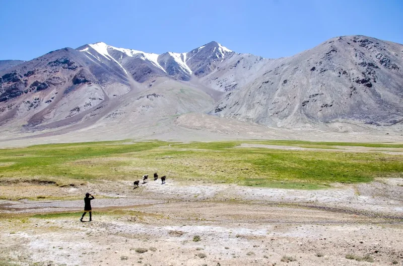
In the 19th century, the Pamirs became the stage for the "Great Game"—the strategic rivalry between the British and Russian Empires for supremacy in Central Asia. Surveyors, spies, and soldiers from both empires mapped these valleys in a high-stakes game of mountain exploration. The current borders of Tajikistan, Afghanistan, and China are a direct legacy of this era, often drawn by diplomats in distant cities with little regard for the nomadic peoples who lived here. Today, the Eastern Pamir is primarily inhabited by ethnic Kyrgyz nomads. Their culture is inextricably linked to the landscape; they are masters of high-altitude survival, living in felt yurts and relying on yaks for milk, meat, and transport. Encountering a Kyrgyz "jailoo" (summer pasture) is a highlight of the trek, offering a glimpse into a way of life that has remained largely unchanged for centuries.
The region also holds significant geological history. The Pamir Knot was formed by the ongoing collision of the Indian and Eurasian tectonic plates, a process that continues to push these mountains skyward. The presence of Karakul Lake, one of the highest meteoritic craters in the world, adds a celestial dimension to the landscape. For the people of Tajikistan, the Pamirs are a source of immense national pride, home to the highest peaks in the former Soviet Union and a bastion of unique Pamiri languages and Ismaili Muslim traditions that differ significantly from the rest of the country.
Want more background? Read extended notes on history and cultural context → Learn more
Seasonal Highlights and Weather Reality
The window for trekking in the Eastern Pamir is exceptionally narrow. Due to the extreme altitude and northern latitude, the region experiences a "polar" desert climate. For nine months of the year, the passes are choked with snow and temperatures are lethally cold.
July to August (Peak Season): This is the most reliable time for the trek. The snow on the high passes (4,500m+) has usually melted sufficiently to allow passage without technical mountaineering gear. Daytime temperatures in the valleys can reach a pleasant 20°C to 25°C, though the sun feels much hotter due to the thin atmosphere. However, even in mid-summer, night-time temperatures frequently drop to -5°C or -10°C. This is also the time when the Kyrgyz nomads are at their summer pastures, providing opportunities for cultural interaction.
September (Shoulder Season): September offers the most stable weather and the clearest skies. The summer haze disappears, providing staggering views of the distant peaks. However, the risk of early-season snowstorms increases significantly, and night-time temperatures begin to drop further, often reaching -15°C at higher camps. By late September, most nomads have begun their descent to winter quarters, and the landscape takes on a golden, autumnal hue.
Winter and Spring (October to June): Trekking is effectively impossible for recreational hikers during this period. Temperatures in Murghab can drop to -45°C, and the high plateau becomes a frozen wasteland. Spring (May-June) is particularly dangerous due to rapid snowmelt, which turns small streams into impassable, raging torrents and creates high avalanche risk on the slopes.
Recommended Itinerary

12-Day Pamir Desert Traverse
Day 1: Kyzyl-Art Pass to Karakul Lake
- Distance: 18 km
- Elevation gain: 100 m (mostly descent)
- Time: 5–6 hours
- Start at the Tajikistan-Kyrgyzstan border (4,280 m)
- Descend into the vast Karakul basin
- First views of the massive meteorite crater lake
- Camp on the northern shores of Karakul
- Acclimatisation is the primary focus; the air is thin and movement should be slow
Day 2: Karakul Shoreline to Karart Valley
- Distance: 22 km
- Elevation gain: 150 m
- Time: 7–8 hours
- Trek along the eastern edge of the lake
- Pass through abandoned Soviet-era structures
- Enter the mouth of the Karart Valley
- The landscape is exceptionally flat but the distance is taxing at this altitude
Day 3: Karart Valley to Base of Ak-Baital
- Distance: 16 km
- Elevation gain: 400 m
- Time: 6 hours
- Follow the dry riverbed deeper into the mountains
- The terrain becomes more rugged and rocky
- Camp at 4,400 m near a small glacial stream
- Prepare for the first major pass crossing
Day 4: Crossing the Ak-Baital Pass (West)
- Distance: 14 km
- Elevation gain: 450 m gain, 600 m descent
- Time: 7–9 hours
- Steep ascent to the pass (4,850 m)
- Spectacular views of the Muzkol Range
- Descent into a narrow, winding canyon
- Camp at the confluence of two seasonal streams
Day 5: Canyon Descent to Pshart Valley
- Distance: 20 km
- Elevation: 800 m descent
- Time: 7–8 hours
- Navigate through technical scree slopes and narrow gorges
- The valley opens up into the wide Pshart Valley
- First sightings of Kyrgyz yurt camps
- Camp near a nomad settlement; possible opportunity to buy fresh yak milk
Day 6: Pshart Valley Exploration
- Distance: 15 km
- Elevation: Minimal
- Time: 5 hours
- A shorter day to recover from the pass crossing
- Walk through wide alpine meadows (jailoos)
- Observe the nomadic lifestyle and yak herding
- Camp near the base of the Gumbezkul Pass
Day 7: Gumbezkul Pass to Madiyan Valley
- Distance: 18 km
- Elevation: 600 m gain, 700 m descent
- Time: 8–10 hours
- Challenging ascent to Gumbezkul Pass (4,730 m)
- Panoramic views of the Eastern Pamir Plateau
- Long descent into the Madiyan Valley
- Camp near the Madiyan River
Day 8: Madiyan Valley to Hot Springs
- Distance: 22 km
- Elevation: 200 m descent
- Time: 7–8 hours
- Follow the Madiyan River downstream
- The valley walls are vibrant shades of red and purple
- Arrive at the Madiyan Hot Springs (basic concrete pools)
- A rare chance to wash and soak tired muscles
Day 9: Madiyan to Jarty-Gumbez
- Distance: 19 km
- Elevation: 300 m gain
- Time: 6–7 hours
- Trek toward the Jarty-Gumbez hunting camp area
- High probability of seeing Marco Polo sheep (Argali) on the ridges
- The landscape becomes increasingly arid and desert-like
- Camp in a sheltered side-valley
Day 10: Jarty-Gumbez to Shurali
- Distance: 21 km
- Elevation: 100 m gain
- Time: 7–8 hours
- Cross high, windswept plains
- Pass ancient "gumbez" (domed burial structures)
- The scale of the landscape is overwhelming here
- Camp at Shurali, a remote summer pasture
Day 11: Shurali to Murghab Outskirts
- Distance: 20 km
- Elevation: 400 m descent
- Time: 7 hours
- The final stretch toward the regional hub of Murghab
- The Murghab River becomes a constant companion
- Distant views of the town's white-washed houses
- Final night of wild camping
Day 12: Arrival in Murghab
- Distance: 15 km
- Elevation: Minimal
- Time: 4 hours
- Walk into Murghab (3,600 m)
- Finish at the local bazaar (made of shipping containers)
- Check into a local guesthouse for a bed and a hot meal
- End of trek
Planning and Bookings
Book Your Trip
Everything you need to plan your journey
Accommodation
Find places to stay near Murghab
Flights
Search flights to Murghab
Essential Preparation
The Pamir Mountain Desert Trek requires a level of preparation far beyond a standard mountain hike. The primary challenge is the altitude; the entire trek takes place above 3,500 metres, with multiple passes near 5,000 metres. Trekkers must spend at least 3–4 days acclimatising in Osh (Kyrgyzstan) or Murghab (Tajikistan) before starting. Physical fitness is paramount, but mental fortitude is equally important for dealing with the isolation and harsh conditions.
Logistics are complex. Most trekkers fly into Osh, Kyrgyzstan, and hire a 4x4 to reach the trailhead at the Kyzyl-Art Pass. This journey takes 12–18 hours on the Pamir Highway. You must coordinate your transport carefully, as there is no public transport to the trailhead. It is highly recommended to hire a local guide and pack animals through PECTA (Pamir Eco-Tourism Association) in Murghab or Khorog. They can help with route finding, cultural translation, and emergency logistics.
Trail Accommodation
There is no formal accommodation on the Pamir Mountain Desert Trek. This is a wilderness expedition where you must be prepared for wild camping every night.
Accommodation Types:
- Wild Camping: You will pitch your own tent in remote valleys. Sites are chosen based on proximity to water and shelter from the wind.
- Kyrgyz Yurts: Occasionally, you may be invited to stay in a nomad's yurt. This is a cultural experience rather than a booking. Expect to sleep on floor mats and pay a small fee (approx. US$10–15) for the stay and a meal.
- Murghab Guesthouses: At the end of the trek, Murghab offers basic homestays. These provide a bed, heavy blankets, and home-cooked meals. Facilities are simple (pit toilets, bucket showers).
What is NOT Provided:
- There are no huts, shelters, or designated campsites.
- There are no toilets or waste disposal facilities on the trail.
- There is no electricity, mobile signal, or WiFi for the duration of the trek.
- There are no shops or resupply points between the start and end.
Required Gear
- 4-Season Tent: Must be able to withstand high winds and potential snow loads. Lightweight 3-season tents will fail in a Pamir storm.
- Sleeping Bag: Rated to at least -15°C (comfort rating). Even in July, temperatures at 4,500m can drop significantly.
- Trekking Boots: Sturdy, waterproof, and well-worn. The terrain is a mix of sharp volcanic rock, scree, and occasional marshy ground.
- Navigation: A high-quality GPS device with offline maps (e.g., Gaia GPS or Garmin) and a paper map/compass. The trail is often non-existent.
- Satellite Communicator: (Garmin inReach or Zoleo). Essential for emergencies as there is zero mobile coverage.
- Multi-fuel Stove: Gas canisters are difficult to find in Tajikistan. A stove that runs on petrol (available in Murghab/Osh) is more reliable.
- Water Filter: A high-capacity filter (e.g., Katadyn or Sawyer) is essential. Water sources are often silty or near livestock.
What to Bring
- Food: All calories for 12–14 days. Focus on high-energy, lightweight dried foods. Fresh produce is unavailable.
- Water Treatment: Chlorine or iodine tablets as a backup to your primary filter.
- Sun Protection: SPF 50+ sunscreen, lip balm with SPF, and Category 4 glacier sunglasses. The UV radiation at this altitude is extreme.
- Clothing Layers: Merino wool base layers, a heavy down jacket, waterproof hardshell, and thermal gloves/hat.
- First Aid Kit: Must include Diamox (for altitude), broad-spectrum antibiotics, rehydration salts, and blister care.
- Gifts for Nomads: Small items like tea, sugar, or school supplies for children are appreciated if you stay in a yurt.
- Cash: US Dollars (clean, crisp bills) or Tajik Somoni. There are no ATMs in the mountains.
Permits
Navigating the bureaucracy of Tajikistan is a critical part of the planning process. Because the trek takes place in the Gorno-Badakhshan Autonomous Region (GBAO), a standard Tajik visa is not sufficient.
Mandatory Permits:
- Tajik E-Visa: Most nationalities can apply online. Ensure you select the "GBAO Permit" checkbox during the application. This permit allows you to enter the restricted Pamir region.
- OVIR Registration: If staying in Tajikistan for more than 10 days, you must register with the Migration Police (OVIR). Most guesthouses in Murghab or Khorog can assist with this for a small fee.
- Tajik National Park Fee: The trek passes through the Tajik National Park (a UNESCO site). Fees are typically paid in Murghab at the PECTA office or to rangers if encountered on the trail (approx. 15–20 Somoni per day).
- Border Zone Permits: Since the trek runs close to the Chinese border, additional "Border Zone" permits may be required for specific valleys. Check current regulations with PECTA before departing.
Logistical Tips: Carry at least 10 photocopies of your passport, visa, and GBAO permit. You will encounter military checkpoints (posts) along the Pamir Highway and occasionally near the trail. The soldiers will need to record your details, and providing a photocopy speeds up the process significantly.
Other Activities in the Area
The Pamirs offer more than just trekking. Consider these additions to your itinerary:
- The Pamir Highway (M41): One of the world's greatest road trips. Hire a 4x4 and travel from Murghab to Khorog, crossing the 4,655m Ak-Baital Pass, the highest point on the highway.
- Wakhan Valley: A stunning valley bordering Afghanistan. Visit ancient Silk Road fortresses like Yamchun, soak in the Bibi Fatima hot springs, and look across the river at Afghan villages.
- Yashilkul and Bulunkul Lakes: Beautiful high-altitude lakes known for their changing colours and excellent birdwatching.
- Khorog Botanical Garden: One of the highest botanical gardens in the world, offering a lush contrast to the desert plateau.
- Murghab Bazaar: Explore the unique market housed in shipping containers, where you can buy Kyrgyz felt carpets (shyrdaks) and traditional Pamiri hats.
Safety and Conditions
Altitude Sickness: This is the single greatest risk. Acute Mountain Sickness (AMS) can progress to High Altitude Pulmonary Oedema (HAPE) or Cerebral Oedema (HACE), both of which are fatal. The only cure is immediate descent. Because the plateau is so high, "descending" often requires travelling many kilometres. Never ascend more than 300–500 metres of sleeping altitude per day once above 3,000 metres.
Extreme Weather: The Pamir weather is notoriously fickle. Sandstorms can reduce visibility to metres in minutes, and sudden snowstorms can occur even in August. Hypothermia is a constant threat if you get wet or if the wind picks up. Always have your hardshell and warm layers accessible.
Water and Hygiene: Water sources are limited. Many streams are seasonal or contaminated by livestock. Always filter or treat your water. Giardia and other waterborne illnesses will end your trek quickly. Practice strict hand hygiene, especially if interacting with local livestock.
Isolation: You are days away from medical help. A broken ankle or a severe infection requires a complex and expensive helicopter evacuation, which is not always available in Tajikistan. Carry a comprehensive first aid kit and a satellite communication device. Ensure your travel insurance specifically covers "search and rescue" and "high-altitude trekking up to 5,000m."
River Crossings: Glacial rivers rise significantly in the afternoon as the sun melts the ice. Always aim to cross major rivers early in the morning when the water level is at its lowest. Never cross a river alone.
Side Trips and Points of Interest
Karakul Meteorite Crater: Spend an extra day at the start of the trek exploring the shores of Karakul. The lake sits at 3,914 metres and is surrounded by a ring of mountains. The salt crusts along the shore and the abandoned Soviet weather station provide eerie, beautiful photographic opportunities.
Marco Polo Sheep Spotting: The mountains around Jarty-Gumbez are one of the last strongholds of the Argali (Marco Polo sheep), famous for their massive, spiralling horns. Bring binoculars and scan the high ridges at dawn or dusk.
Ancient Petroglyphs: Scattered throughout the Pshart and Madiyan valleys are ancient rock carvings depicting ibex, hunters, and solar symbols. These date back thousands of years and are often found on sun-blackened boulders near old nomadic routes.
Madiyan Hot Springs: Located in a dramatic red-rock canyon, these springs are a literal lifesaver for weary trekkers. The water is rich in minerals and naturally hot. While the facilities are very basic, the experience of soaking in hot water while looking up at 4,000-metre peaks is unforgettable.
Leave No Trace
The Pamir desert is an incredibly fragile environment. Because of the cold and lack of moisture, decomposition happens very slowly. A piece of litter or human waste can remain visible for decades. The "cryptobiotic" soil crust—a living layer of lichens and mosses that prevents erosion—takes hundreds of years to form and can be destroyed by a single footstep.
LNT Principles for the Pamir:
- Pack It In, Pack It Out: This includes all trash, including "biodegradable" items like orange peels or tea bags, which do not rot in this climate.
- Human Waste: Use the "cat hole" method, digging at least 15–20 cm deep and at least 60 metres from any water source. Pack out your toilet paper in a sealed bag.
- Stay on Trails: Where a trail exists, stay on it. In open desert, spread out your group to avoid creating new "social trails" that lead to erosion.
- Respect Wildlife: Do not approach or disturb Marco Polo sheep or ibex. Use binoculars for viewing.
- No Campfires: Wood is non-existent in the high desert. Burning the small, slow-growing shrubs (like teresken) deprives the soil of nutrients and removes vital habitat for small animals. Use a stove for all cooking.