Paine Circuit - The Ultimate Patagonian Odyssey
The Paine Circuit, often referred to as the "O" Trek, is the definitive wilderness experience in Chile’s Torres del Paine National Park. Spanning approximately 130 kilometres, this challenging multi-day loop encompasses the world-famous "W" Trek but extends deep into the remote northern reaches of the Cordillera del Paine. It is a journey of profound contrasts, transitioning from the golden pampas of the Patagonian steppe to the high alpine environment of the Paso John Gardner, where hikers are confronted by the staggering expanse of the Southern Patagonian Ice Field. Unlike the more crowded southern trails, the back side of the circuit offers a sense of isolation and raw natural beauty that is increasingly rare in modern trekking. This is a route that demands physical endurance, meticulous planning, and a deep respect for the volatile weather systems of the southern hemisphere. For those who complete the full circle, the reward is a comprehensive understanding of one of the most geologically dramatic landscapes on Earth.
- Distance: 130.0 km loop
- Duration: 7–10 days
- Season: October–April (Strictly regulated; trail sections close in winter)
- Elevation Gain: Approximately 9,300 m total cumulative gain
- Highest Point: Paso John Gardner (1,200 m)
- Difficulty: Very Challenging (Requires high fitness and multi-day trekking experience)
- Direction: Counter-clockwise only (Mandatory regulation by CONAF)
Overview
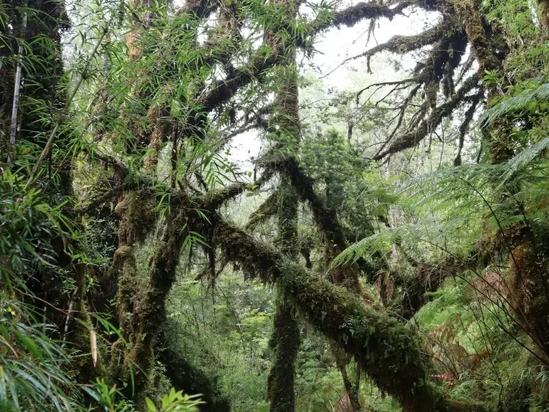
The Paine Circuit is widely considered one of the premier long-distance treks in the world, offering a 360-degree perspective of the iconic granite massifs that define Torres del Paine. While the "W" Trek captures the park's most famous landmarks—the Base of the Towers, the French Valley, and Grey Glacier—the "O" Circuit provides the essential context of the mountain range. By circumnavigating the entire Paine Massif, trekkers witness the transition of ecosystems, from the wind-swept eastern plains to the lush, ancient Lenga and Coihue forests of the western valleys. The route is a masterclass in geological diversity, featuring turquoise glacial lakes, thundering waterfalls, and the immense, creaking rivers of ice that flow from the ice field.
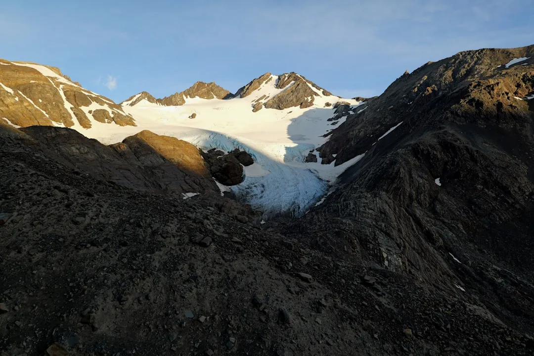
The defining characteristic of the Paine Circuit is its physical and psychological progression. The first few days on the northern side are relatively gentle in terms of elevation but provide a sense of solitude that vanishes once the trail merges with the "W" route. The crux of the journey is the ascent of Paso John Gardner. This section requires a climb through dense forest and over loose scree to a pass that frequently experiences hurricane-force winds. Standing at the summit of the pass, hikers are greeted by the sight of Glacier Grey—a massive tongue of ice stretching as far as the eye can see. This moment is often described as the emotional peak of the trek, a humbling encounter with the sheer scale of the Patagonian wilderness.
Logistically, the circuit is a complex undertaking. It requires staying in a mix of campsites and refugios managed by three different entities: CONAF (the national forest corporation), and two private concessionaires, Vertice Patagonia and Las Torres Patagonia. Because the park limits the number of trekkers on the "O" section to approximately 80 people per day, the experience remains intimate. However, this also means that bookings must be secured months in advance. For the prepared hiker, the Paine Circuit is more than just a walk; it is a transformative endurance test through a landscape that feels as though it belongs to a different geological epoch.
History and Cultural Context
The human history of the region surrounding the Paine Circuit dates back thousands of years to the Aonikenk people, also known as the Tehuelches. These nomadic hunter-gatherers roamed the Patagonian plains, following the seasonal migrations of guanacos. The name "Paine" itself is derived from the Aonikenk word for "blue," a tribute to the startling colour of the glacial lakes that dot the landscape. For the Aonikenk, these mountains were not merely landmarks but spiritual entities, woven into a complex mythology of the land. European contact in the late 19th century led to the displacement of the indigenous populations as the region was partitioned for large-scale sheep farming, or "estancias."
The first recorded western exploration of the area was led by Lady Florence Dixie in 1879. An aristocratic Scottish writer and traveller, Dixie published "Across Patagonia," in which she dubbed the three granite spires the "Cleopatra’s Needles." Her accounts sparked international interest in the region's jagged peaks and wild beauty. In the early 20th century, explorers like Alberto de Agostini, a Salesian priest and mountaineer, began documenting the glaciers and peaks with greater scientific and photographic precision, laying the groundwork for the area's eventual protection.
Torres del Paine National Park was officially established in 1959, originally under the name Parque Nacional de Turismo Lago Grey. It was renamed in 1970 and designated a UNESCO Biosphere Reserve in 1978. In recent decades, the park has faced significant environmental challenges, most notably human-caused forest fires in 1985, 2005, and 2011. These fires, started by negligent hikers, destroyed tens of thousands of hectares of native forest, leading to the strict regulations currently in place regarding campfires and stove use. Today, the Paine Circuit stands as a testament to both the resilience of the Patagonian ecosystem and the ongoing efforts to balance international tourism with the preservation of a fragile wilderness.
Want more background? Read extended notes on history and cultural context → Learn more
Seasonal Highlights and Weather Reality
The trekking season for the Paine Circuit is strictly limited to the southern hemisphere's late spring, summer, and early autumn (October to April). Outside of this window, the northern section of the loop, particularly the Paso John Gardner, is closed to the general public due to heavy snow, extreme winds, and the absence of park rangers. Even during the peak season, Patagonia is famous for experiencing "four seasons in one day." Hikers must be prepared for sudden shifts from intense sunshine to torrential rain or sleet within minutes.
Spring (October to November): This is the shoulder season, offering the best chance to see the park's flora in bloom, including the vibrant red Chilean Firebush (Ciruelillo). The weather is notoriously unstable and wind speeds begin to pick up. However, the trails are less crowded, and the peaks are still heavily draped in winter snow, providing spectacular photographic opportunities. Temperatures typically range from 2°C to 15°C.
Summer (December to February): This is the most popular time to hike. The days are incredibly long, with up to 17 hours of daylight, allowing for a relaxed pace. However, this is also the windiest period. The "Winds of Patagonia" can reach speeds of over 100 kilometres per hour, particularly on the exposed ridges of the circuit. Campsites are at full capacity, and the social atmosphere at the refugios is at its peak. Temperatures range from 6°C to 20°C.
Autumn (March to April): Many experienced trekkers consider this the best time for the Paine Circuit. The wind begins to die down, and the Lenga forests turn brilliant shades of orange and red. The air is crisp and clear, often providing the best visibility of the towers and the ice field. However, the nights become significantly colder, and there is an increased risk of early snowfall on the pass. Temperatures range from -2°C to 13°C.
Regardless of the month, the wind is the defining factor of the Patagonian climate. It can sap body heat rapidly and make walking with a heavy pack physically exhausting. Waterproof and windproof layers are not optional; they are essential survival gear.
Recommended Itinerary
8-Day Paine Circuit Itinerary
Day 1: Laguna Amarga to Campamento Serón
- Distance: 13.5 km
- Elevation gain: 250 m
- Time: 4–5 hours
- Morning bus from Puerto Natales to Laguna Amarga entrance
- Registration with CONAF and shuttle to Centro de Bienvenida
- Easy walk through the eastern pampas and open meadows
- Pass through areas of Daisy-filled fields and along the Rio Paine
- Look for guanacos and rheas (Patagonian ostriches) along the trail
- Arrive at Campamento Serón, a peaceful site on a former estancia
- This day serves as a gentle introduction to the terrain and allows for pack adjustments
Day 2: Campamento Serón to Refugio Dickson
- Distance: 18.5 km
- Elevation gain: 400 m
- Time: 6–7 hours
- Climb over a moderate ridge with views of Lago Paine
- Traverse the "Paso de los Vientos" (Pass of the Winds)
- Descend into a lush valley following the river towards the mountains
- Pass through wetlands and small Coihue forests
- Arrive at Refugio Dickson, arguably the most beautiful campsite in the park
- The site sits on a peninsula overlooking Lago Dickson and the Dickson Glacier
- Excellent spot for evening photography as the sun sets over the ice
Day 3: Refugio Dickson to Campamento Los Perros
- Distance: 12 km
- Elevation gain: 350 m
- Time: 4.5–5.5 hours
- Walk through ancient, moss-covered Lenga forests
- Gradual but steady climb deeper into the mountains
- Cross several suspension bridges over glacial streams
- Pass the spectacular Glacier Perros and its terminal lake
- Arrive at Campamento Los Perros, the highest and coldest camp on the circuit
- Early night recommended to prepare for the pass crossing the following morning
- Note: This is a "dry" camp with basic facilities and no hot showers
Day 4: Campamento Los Perros to Refugio Grey (via Paso John Gardner)
- Distance: 15 km
- Elevation: 700 m gain, 1,200 m descent
- Time: 8–11 hours
- The most challenging and rewarding day of the circuit
- Steep climb through mud and then over loose rock and scree to the pass
- Reach Paso John Gardner (1,200 m) for a breathtaking view of the Southern Patagonian Ice Field
- Extremely high winds are common at the summit; do not linger if conditions are poor
- Long, knee-jarring descent through forest with constant views of Glacier Grey
- Pass Campamento Paso (ranger station) and continue over three massive suspension bridges
- Arrive at Refugio Grey, located near the face of the glacier
Day 5: Refugio Grey to Paine Grande
- Distance: 11 km
- Elevation: 200 m gain, 250 m descent
- Time: 3.5–4.5 hours
- Relatively easy walk along the shores of Lago Grey
- Multiple viewpoints of the glacier's face and floating icebergs
- Transition from the remote "O" section to the busier "W" trail
- Walk through the "Quebrada de los Vientos" (Windy Gully)
- Arrive at Paine Grande, the largest hub in the park with a bar and mini-market
- Views of the Cuernos del Paine (Horns of Paine) across Lago Pehoé
Day 6: Paine Grande to Refugio Los Cuernos (via Valle del Francés)
- Distance: 25 km (including French Valley detour)
- Elevation: 600 m gain, 600 m descent
- Time: 8–10 hours
- Leave heavy packs at Campamento Italiano (ranger station)
- Hike up the French Valley to the "Mirador Francés" for views of the hanging glacier
- Continue to "Mirador Británico" for a 360-degree amphitheatre of granite peaks
- Descend back to Italiano and collect packs
- Continue along the base of the Cuernos to Refugio Los Cuernos or Domos Francés
- The trail follows the pebble beaches of Lago Nordenskjöld
Day 7: Refugio Los Cuernos to Refugio Chileno
- Distance: 14 km
- Elevation: 400 m gain
- Time: 5–6 hours
- Follow the shoreline of Lago Nordenskjöld with the Cuernos towering above
- Ascend into the Ascencio Valley via a steep, windy pass
- The trail hugs the side of the mountain with the Rio Ascencio far below
- Arrive at Refugio Chileno, nestled in the forest by the river
- This location is strategic for a sunrise hike to the Towers the next morning
Day 8: Refugio Chileno to Mirador Las Torres and return to Central
- Distance: 12 km
- Elevation: 500 m gain, 900 m descent
- Time: 6–8 hours
- Pre-dawn start (approx. 3:00 AM) to reach the towers for sunrise
- Final steep climb over a massive boulder field (the "Moraine")
- Arrive at Mirador Las Torres to see the three granite spires turn glowing orange
- Descend back to Chileno for breakfast and then down to Hotel Las Torres/Central
- Take the shuttle to Laguna Amarga and the bus back to Puerto Natales
Planning and Bookings
Book Your Trip
Everything you need to plan your journey
Accommodation
Find places to stay near Puerto Natales
Flights
Search flights to Puerto Natales
Essential Preparation
The Paine Circuit is a logistically demanding trek that requires preparation to begin at least six months in advance. The primary hurdle is the booking system, which is split between three different organisations. You cannot simply show up and hike; rangers at various checkpoints will verify your reservations for every single night of the circuit. If you do not have a confirmed booking for the next camp, you will be turned back.
Physical preparation is equally vital. You will be carrying a pack weighing between 12 and 18 kilograms (depending on whether you are camping or staying in refugios) for 7 to 10 consecutive days. Training should focus on cardiovascular endurance and leg strength, ideally involving long hikes with a weighted pack. Puerto Natales is the essential base town for the trek. It is located approximately two hours from the park and offers numerous gear rental shops, supermarkets, and hostels. It is recommended to spend at least two nights in Puerto Natales before starting to finalise gear and attend the daily "3:00 PM Talk" at Erratic Rock, which provides invaluable up-to-date trail information.
Trail Accommodation
Accommodation on the Paine Circuit is a mix of Refugios (mountain hostels) and Campamentos (campsites). These are managed by CONAF (government), Vertice Patagonia (private), and Las Torres Patagonia (private).
Refugios: These offer dormitory-style bunks. They provide a mattress, and you can rent "made-up beds" (sheets and blankets) or use your own sleeping bag. Refugios have shared bathrooms, hot showers (usually), and a dining hall where pre-booked meals are served. They are expensive but significantly reduce pack weight.
Campsites: Every refugio has an associated campsite. You can either bring your own tent and gear or rent a "pre-set" tent which includes a sleeping bag and mat already set up for your arrival. Campsites have access to shared bathrooms and, in most cases, a designated cooking shelter (quincho). Note that Campamento Los Perros and Campamento Paso are more basic, with cold water only and limited facilities.
Booking Entities:
- Las Torres Patagonia: Manages Serón, Cuernos, Francés, Chileno, and Central.
- Vertice Patagonia: Manages Dickson, Los Perros, Grey, and Paine Grande.
- CONAF: Manages Campamento Paso (currently often used only as a ranger station or emergency stop).
Required Gear
- Trekking Boots: High-cut, waterproof boots with a stiff sole are essential for the mud of the "O" and the rocks of the Pass.
- Backpack: 50–70L for campers; 35–45L for those staying in refugios with meal plans. Must have a high-quality rain cover.
- Layering System: Moisture-wicking base layers (merino is best), a fleece or down mid-layer, and a high-quality Gore-Tex hardshell jacket.
- Trousers: Quick-drying trekking trousers. Avoid denim at all costs. Waterproof overtrousers are mandatory for the Pass.
- Sleeping Bag: Rated to at least -5°C comfort level. Even in summer, night temperatures can drop below freezing.
- Trekking Poles: Highly recommended to save knees on the 1,200 m descent from Paso John Gardner and for stability in high winds.
- Head Torch: Essential for the sunrise hike to the Towers and for navigating campsites at night.
What to Bring
- Food: If self-catering, bring lightweight, high-calorie dehydrated meals. Food is available for purchase at some refugios (Paine Grande, Grey) but is extremely expensive.
- Water Treatment: While many hikers drink directly from the streams, a lightweight filter or Steripen is recommended for peace of mind, especially near high-traffic campsites.
- Sun Protection: The ozone layer is thin here. Bring SPF 50+ sunscreen, lip balm with SPF, and high-quality sunglasses.
- First Aid: Focus on blister care (Compeed, moleskin), ibuprofen, and any personal medications.
- Dry Bags: Use these inside your pack to ensure your sleeping bag and spare clothes stay dry during Patagonian downpours.
- Power Bank: Charging outlets are rare and often crowded in refugios. Bring a high-capacity portable charger.
- Toiletries: Biodegradable soap, a quick-dry travel towel, and wet wipes (for "dry" camps).
Permits
There is no single "permit" for the Paine Circuit; instead, your permits are your confirmed accommodation bookings. Without a reservation for every night, you will not be allowed to enter the "O" section of the trail. The booking window typically opens in May or June for the following season (October–April). Due to the limited capacity of the northern campsites (Serón, Dickson, Los Perros), these spots sell out almost instantly.
Booking Strategy:
- Determine your start date and work counter-clockwise.
- Open the websites for Vertice Patagonia and Las Torres Patagonia simultaneously.
- Book the "O" section first (Serón, Dickson, Los Perros) as these are the bottleneck.
- Once the back side is secured, book the "W" section (Grey, Paine Grande, Francés/Cuernos, Chileno).
- Ensure you have a PDF or printed copy of all confirmations; you will be asked for them at the Laguna Amarga entrance and at various ranger stations.
Park Entrance Fees: In addition to accommodation, you must purchase a park entrance ticket via the "Pase Parque" website (asf.conaf.cl). For international visitors staying more than three days, the cost is approximately US$49. This must be purchased online in advance as no cash is accepted at the park gates.
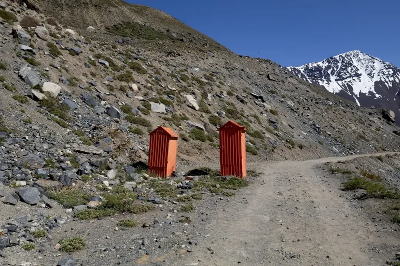
Mandatory Check-in: All "O" trekkers must check in at the CONAF office at Laguna Amarga or the Centro de Bienvenida. Rangers will provide a safety briefing and verify that you have the appropriate gear and all necessary reservations.
Other Activities in the Area
If you have extra time before or after your trek, the region offers several world-class experiences:
- Glacier Grey Ice Hiking: From Refugio Grey, you can join a guided excursion to walk on the glacier itself. This involves a boat transfer to the ice and the use of crampons and ice axes to explore crevasses and ice caves.
- Kayaking Lago Grey: Paddle among massive blue icebergs that have calved off the glacier. This provides a unique perspective on the scale of the ice face.
- Puma Tracking: The eastern side of the park is one of the best places in the world to see wild pumas. Specialist guides offer multi-day tracking tours (best done outside of your trekking dates).
- Milodon Cave (Cueva del Milodón): Located near Puerto Natales, this massive natural cave is where the remains of a prehistoric giant ground sloth were discovered in 1895.
- Navimag Ferry: For a slow-travel approach, take the four-day ferry from Puerto Montt to Puerto Natales, navigating through the spectacular fjords of southern Chile.
Safety and Conditions
The Crux: Paso John Gardner: This is the most dangerous section of the trail. The pass is highly exposed to the elements. If the park rangers at Campamento Los Perros deem the weather too dangerous (usually due to wind speeds exceeding 80–90 km/h or heavy snow), they will close the pass. Never attempt to bypass a closure. If you are caught in high winds on the pass, stay low to the ground and move carefully between gusts.
Hypothermia: Even in mid-summer, the combination of rain and high wind can lead to rapid onset hypothermia. Always keep a set of dry clothes in a waterproof bag and put on your hardshell layers before you get wet, not after.
Water Safety: While the water in the park is generally pristine, do not drink from stagnant ponds or downstream from large campsites. Use a filter if you are unsure. Be cautious during river crossings after heavy rain; small streams can turn into torrents quickly.
Navigation: The trail is generally well-marked with red or orange markers and signposts at major junctions. However, in whiteout conditions on the pass, markers can be obscured. Carrying an offline GPS map (such as Maps.me or Gaia GPS) is highly recommended.
Emergency Services: There is no mobile phone reception on the "O" Circuit. Refugios have satellite radios for emergencies. If an injury occurs, the evacuation process is difficult and expensive, often involving horses or, in extreme cases, a helicopter from Punta Arenas. Ensure your travel insurance specifically covers "high-altitude trekking" and "emergency evacuation."
Side Trips and Points of Interest
Mirador Británico: Located at the very end of the French Valley, this viewpoint offers a 360-degree panorama of the granite peaks, including Cerro Catedral, Aleta de Tiburón (Shark’s Fin), and the Paine Grande massif. It is a strenuous addition to an already long day, but in clear weather, it is arguably the most spectacular view in the park.
The Suspension Bridges: Between Campamento Paso and Refugio Grey, the trail crosses three massive suspension bridges hanging high above deep ravines. These bridges offer incredible views of the side of Glacier Grey and are a highlight for those who enjoy a bit of adrenaline.
Lago Dickson: Take the time to walk down to the pebble beach at Refugio Dickson. The lake is often filled with small icebergs, and the silence of this remote northern corner of the park is profound. It is one of the few places where you can truly escape the "W" Trek crowds.
The Moraine: The final climb to the Base of the Towers is over a massive field of glacial debris. While exhausting, the geology of the moraine is fascinating, showing the historical extent of the glacier that once carved the valley. Look for the "Towers" appearing and disappearing behind the rocks as you ascend.
Leave No Trace
Torres del Paine is a fragile ecosystem that has been severely damaged by human negligence in the past. The park authorities enforce Leave No Trace principles with extreme rigour. Failure to comply can result in immediate expulsion from the park and heavy fines.
The Fire Ban: Lighting a fire anywhere in the park is strictly prohibited and is a criminal offence. This includes campfires and smoking outside of designated areas. Cooking is only permitted in the specific shelters (quinchos) provided at campsites. If you are caught using a stove on the trail, you will be removed from the park by police.
Waste Management: You must pack out all of your trash. This includes organic waste like orange peels or apple cores, which do not decompose quickly in the cold Patagonian climate and can harm local wildlife. Use the bins provided at the major refugios, but aim to carry your waste back to Puerto Natales.
Stay on the Path: The "O" Circuit passes through sensitive peat bogs and alpine meadows. Stepping off the trail to avoid mud causes "braiding," which destroys vegetation and leads to erosion. Wear gaiters and walk through the mud, not around it.
Wildlife: Do not feed or approach wildlife. This includes the foxes that often frequent campsites and the guanacos. Keep a respectful distance and use a zoom lens for photos.