Pacific Rim Trail - A Coastal Odyssey Through Ancient Wilderness
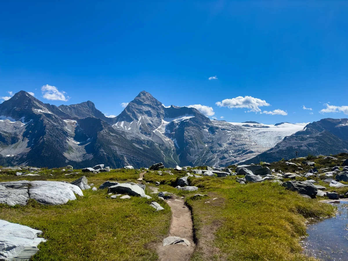
The Pacific Rim Trail, widely recognised as one of the most iconic and challenging coastal treks in North America, is a 75-kilometre journey through the rugged southwestern edge of Vancouver Island, Canada. Located within the traditional territories of the Huu-ay-aht, Ditidaht, and Pacheedaht First Nations, this trail offers an unparalleled immersion into the temperate rainforests and wild shorelines of the Pacific Northwest. Stretching between Pachena Bay in the north and the Gordon River in the south, the route is a test of physical endurance and mental fortitude, requiring hikers to navigate over 70 wooden ladders, traverse deep mud pits, cross surge channels, and time their movements with the relentless rhythm of the Pacific tides. This is not merely a walk; it is a pilgrimage through a landscape defined by the "Graveyard of the Pacific," where the ghosts of shipwrecks linger beneath the mist and the ancient Sitka spruces stand as silent sentinels over the crashing surf.
- Distance: 75.0 km one-way
- Duration: 4–6 days
- Season: May 1st to September 30th (strictly regulated; closed in winter)
- Elevation Gain: Approximately 500 m (cumulative, primarily via ladders and inland ridges)
- Difficulty: Moderate to Strenuous (due to technical terrain, weather, and ladders)
- Closest City: Ucluelet / Port Alberni / Victoria
- Trailhead Access: Pachena Bay (North) or Gordon River (South)
- Direction: Can be hiked in either direction (North-to-South is generally considered easier for beginners)
Overview
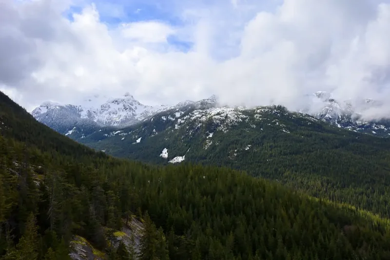
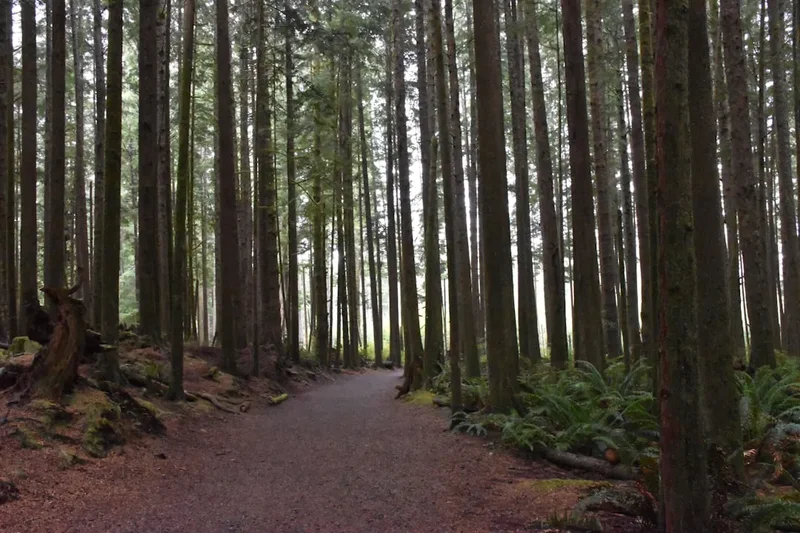
The Pacific Rim Trail is a masterclass in coastal ecology and maritime history. Originally constructed in the early 20th century as a lifesaving route for shipwrecked mariners, the trail has evolved into a world-class hiking destination that attracts thousands of adventurers annually. The experience is defined by its dual nature: the "beach" sections and the "forest" sections. On the beach, hikers find themselves walking on hard-packed sand, navigating slippery sandstone shelves, and scrambling over massive driftwood logs that have been tossed ashore by winter storms. In the forest, the trail transforms into a labyrinth of roots, mud, and boardwalks, where the canopy of Western red cedar and Douglas fir is so thick that even midday can feel like twilight. The sheer physical variety of the trail ensures that no two kilometres are the same, keeping the hiker in a constant state of engagement with the environment.
The technicality of the trail is often underestimated. While the total elevation gain of 500 metres may seem modest over 75 kilometres, this figure does not account for the verticality of the ladders. Some ladder systems descend or ascend over 30 metres into steep ravines, requiring hikers to carry heavy multi-day packs while maintaining three points of contact on rain-slicked rungs. Furthermore, the mud of the Pacific Rim Trail is legendary. In the southern sections, particularly between Camper Bay and Gordon River, the "mud holes" can be knee-deep, requiring careful navigation and the use of gaiters. This is a landscape that demands respect; the weather can shift from brilliant sunshine to bone-chilling fog or torrential rain within an hour, and the tides can trap an unwary hiker against vertical cliffs if they fail to consult their tide tables.
Despite the challenges, the rewards are profound. The trail offers the chance to witness grey whales breaching offshore, sea lions basking on rocky outcrops, and bald eagles soaring above the treeline. The sense of isolation is palpable, yet the shared experience of the trail creates a unique community among hikers. Whether you are huddled around a driftwood fire at Tsusiat Falls or sharing stories at the Nitinaht Narrows crab shack, the Pacific Rim Trail fosters a deep connection to the land and to fellow travellers. It is a journey that strips away the complexities of modern life, leaving only the essentials: the weight of the pack, the sound of the ocean, and the next step forward.
History and Cultural Context
The history of the Pacific Rim Trail is inextricably linked to the First Nations who have inhabited this coastline for millennia. The Huu-ay-aht, Ditidaht, and Pacheedaht peoples have deep ancestral ties to the land, and the trail passes through numerous sites of cultural and spiritual significance. For these nations, the coastline was not a "wilderness" but a bountiful home, providing salmon, cedar, and marine mammals. Today, the trail is co-managed by Parks Canada and the First Nations, and hikers are encouraged to learn about the indigenous history of the region. The Nitinaht Narrows, a tidal gateway where the ocean meets Nitinaht Lake, remains a vital hub for the Ditidaht people, who operate a ferry service and a small seafood stand for hikers, providing a rare and welcome taste of local culture in the heart of the wilderness.
The modern trail owes its existence to the treacherous nature of the Vancouver Island coastline, known as the "Graveyard of the Pacific." Between 1854 and 1906, over 500 ships were lost in these waters due to dense fog, hidden reefs, and violent storms. The most infamous disaster occurred in 1906, when the SS Valencia struck a reef near Pachena Point. Of the 173 people on board, only 37 survived. The tragedy sparked public outrage, leading the Canadian government to establish the Dominion Lifesaving Trail. This route was designed to allow shipwreck survivors to reach safety and for rescuers to transport supplies to the coast. Telegraph lines were strung through the forest, and small shelters were built at regular intervals. As maritime technology improved and the need for a land-based rescue route diminished, the trail fell into disrepair until it was incorporated into Pacific Rim National Park Reserve in 1970 and reimagined as a recreational hiking route.
Walking the trail today, one can still find remnants of this maritime history. Rusted machinery from old shipwrecks, telegraph insulators embedded in ancient trees, and the iconic lighthouses at Pachena Point and Carmanah Point serve as reminders of the lives lost and saved on these shores. The lighthouses remain operational, staffed by keepers who continue the tradition of watching over the dangerous waters. This layer of history adds a somber and reflective dimension to the hike, as one contemplates the power of the ocean and the resilience of those who sought to tame it.
Want more background? Read extended notes on history and cultural context → Learn more
Seasonal Highlights and Weather Reality
The Pacific Rim Trail is only open to the public from May 1st to September 30th. Outside of this window, the trail is closed due to extreme weather conditions, including hurricane-force winds, massive storm surges that wash away beach sections, and heavy rainfall that makes the forest sections impassable. Even within the operating season, weather is the primary factor determining the difficulty of the trek. Hikers must be prepared for "wet" conditions at all times, as the region receives some of the highest rainfall totals in North America.
May and June: These months are characterised by cooler temperatures and a higher probability of rain. The trail is often at its muddiest during this time, as the winter moisture has not yet evaporated. However, the forest is at its most vibrant green, and the crowds are thinner. This is also an excellent time for whale watching, as grey whales migrate north along the coast. Hikers should be prepared for temperatures ranging from 8°C to 15°C.
July and August: This is the peak season, offering the best chance for clear skies and sunshine. Temperatures can reach a pleasant 20°C, though the coastal fog (locally known as "Fog-ust") can roll in at any time, dropping temperatures significantly and reducing visibility to a few metres. The trail is drier, but the popularity of the route means that campsites can be crowded. Reservations are essential and often sell out months in advance.
September: As the season draws to a close, the weather becomes more unpredictable. Early September can offer some of the most beautiful, crisp days of the year, but by the end of the month, the first of the autumn storms begin to arrive. The berries in the forest are ripe, and the light has a golden quality that is perfect for photography. However, the days are shorter, and the risk of a multi-day deluge increases.
Recommended Itinerary
6-Day North-to-South Itinerary
Day 1: Pachena Bay to Michigan Creek
- Distance: 12 km
- Elevation gain: 100 m
- Time: 4–5 hours
- Start at the Pachena Bay trailhead after the mandatory orientation session
- The trail begins in the forest, following a relatively flat and well-maintained path
- Visit the Pachena Point Lighthouse (km 10) and chat with the lighthouse keepers
- Look for sea lions at the haul-out point near the lighthouse
- Arrive at Michigan Creek, the first beach campsite
- This is a gentle introduction to the trail, allowing you to find your rhythm and adjust your pack
Day 2: Michigan Creek to Tsusiat Falls
- Distance: 13 km
- Elevation gain: 50 m
- Time: 5–6 hours
- A mix of beach walking and forest trails
- Pass the remains of the shipwreck "Michigan" at low tide
- Navigate the first set of ladders at Tsocowis Creek
- Arrive at Tsusiat Falls, one of the most spectacular campsites on the trail
- The falls drop directly onto the beach, providing a natural (and very cold) shower
- Set up camp on the sand and enjoy the sound of the crashing surf
Day 3: Tsusiat Falls to Cribs Creek
- Distance: 17 km
- Elevation gain: 100 m
- Time: 6–8 hours
- A long and varied day featuring the Nitinaht Narrows
- Take the ferry across the Narrows, operated by the Ditidaht First Nation
- Stop at the "Crab Shack" for a fresh seafood lunch (bring cash)
- Continue along the coast, navigating the Cheewhat River and Clo-oose forest sections
- Pass the Carmanah Point Lighthouse
- Arrive at Cribs Creek, known for its beautiful tide pools and offshore reefs
Day 4: Cribs Creek to Carmanah Creek
- Distance: 10 km
- Elevation gain: 50 m
- Time: 4–5 hours
- A shorter day that allows for exploration of the Carmanah area
- Walk along the "Green Coast," a section of lush, moss-covered rocks and tide pools
- Navigate the surge channels near Bonilla Point
- Arrive at Carmanah Creek, a wide beach campsite with excellent driftwood for fires
- This is a good day to rest your legs before the more technical southern sections
Day 5: Carmanah Creek to Camper Bay
- Distance: 13 km
- Elevation gain: 150 m
- Time: 6–8 hours
- The difficulty increases as you enter the more rugged southern forest
- Expect significant mud, root systems, and numerous ladder sections
- Cross the Logan Creek suspension bridge, a high and narrow crossing over a deep ravine
- Navigate the Cullite Cove ladders, some of the steepest on the trail
- Arrive at Camper Bay, a forested campsite tucked into a river valley
- The terrain here is slow-going; allow plenty of time for the technical sections
Day 6: Camper Bay to Gordon River
- Distance: 10 km
- Elevation gain: 50 m
- Time: 5–7 hours
- The final push to the southern terminus
- This section is notorious for its deep mud and technical forest hiking
- Pass through the "Thrasher Cove" junction (optional side trip to the beach)
- Navigate the final sets of ladders and the steep descent to the Gordon River
- Summon the ferry across the Gordon River by raising the signal flag
- Celebrate your finish at the Port Renfrew trailhead
Important Notes:
- Tide tables are essential; some beach sections are impassable at high tide
- The ferry at Nitinaht Narrows and Gordon River operates on a set schedule
- Always store food in the provided bear lockers at each campsite
- Water must be treated at all creek crossings
- The southern section (Camper to Gordon) is significantly more difficult than the northern section
Planning and Bookings
Book Your Trip
Everything you need to plan your journey
Accommodation
Find places to stay near Ucluelet
Flights
Search flights to Ucluelet
Essential Preparation
The Pacific Rim Trail is a high-demand destination, and planning should begin at least six to twelve months in advance. The most critical step is securing a reservation through the Parks Canada booking system. Because the trail is located in a remote area of Vancouver Island, logistics require careful coordination. Most hikers base themselves in Ucluelet, Port Alberni, or Victoria before starting. The West Coast Trail Express bus is the primary transport method, providing shuttle services between Victoria, Nanaimo, Port Renfrew (South Trailhead), and Pachena Bay (North Trailhead). If you are driving, you can park your vehicle at one end and take the shuttle to the other.
Physical preparation is non-negotiable. You should be comfortable hiking 15–20 kilometres a day with a 15–20 kg pack. Training should include hill climbs and, if possible, practice on uneven terrain or stairs to simulate the ladder sections. Mental preparation is equally important; be ready for sustained wet weather and the reality of being "stuck" in the mud. Ensure you have a basic understanding of tide charts, as your daily itinerary will be dictated by the ocean's schedule.
Trail Accommodation
Accommodation on the Pacific Rim Trail consists exclusively of designated backcountry campsites. There are no huts or permanent shelters for hikers. Each campsite is located near a water source (usually a creek or river) and is equipped with basic facilities to minimise human impact on the environment.
Campsite Facilities:
- Bear-proof food lockers (mandatory for all food and scented items)
- Pit toilets (bring your own toilet paper)
- Designated clearing areas for tents (usually on the beach or in the forest fringe)
- No potable water (all water must be filtered, boiled, or treated)
- No electricity, rubbish bins, or cell service
What is NOT Provided:
- Shelter: You must bring a high-quality, waterproof tent
- Bedding: A warm sleeping bag and insulated sleeping pad are essential
- Fuel: No firewood is provided; beach fires are permitted using driftwood only (subject to fire bans)
- Cooking equipment: You must carry your own stove and fuel
Costs and Availability:
- The West Coast Trail Overnight Use Fee is approximately $160 CAD per person (subject to change)
- This fee includes the ferry crossings at Nitinaht Narrows and Gordon River
- Reservations open in early spring (usually January or February) and sell out almost instantly for the peak summer months
Required Gear
- Backpack: 55–75L capacity with a high-quality harness and rain cover
- Footwear: Sturdy, waterproof hiking boots with excellent ankle support. Ensure they are well broken-in
- Gaiters: Essential for keeping mud and debris out of your boots in the southern sections
- Rain Gear: A heavy-duty waterproof jacket and overtrousers (Gore-Tex or equivalent)
- Tent: A lightweight, 3-season tent with a full rainfly and waterproof footprint
- Sleeping System: A sleeping bag rated to at least 0°C and a compact sleeping pad
- Navigation: The official Parks Canada map (provided at orientation) and a waterproof tide table
- Safety: A whistle, a basic first aid kit (including blister care), and a multi-tool
- Lighting: A head torch with spare batteries
What to Bring
- Food: Lightweight, high-calorie meals for the duration of your trip, plus one extra day of emergency rations
- Water Treatment: A reliable water filter (pump or gravity) or chemical purification tablets
- Stove and Fuel: A compact canister stove or liquid fuel stove (ensure you have enough fuel for all meals)
- Clothing: Moisture-wicking base layers (merino wool is best), an insulating mid-layer (fleece or down), and several pairs of high-quality hiking socks
- Toiletries: Biodegradable soap, toothbrush, toothpaste, and a small trowel (though pit toilets are available)
- Sun and Bug Protection: Sunscreen, sunglasses, and insect repellent (mosquitoes and "no-see-ums" can be prevalent)
- Cash: Small denominations for the Nitinaht Narrows crab shack and any incidental transport costs
- Emergency Communication: A satellite messenger (like a Garmin inReach) is highly recommended as there is no cell service
Permits
Access to the Pacific Rim Trail is strictly controlled by Parks Canada to preserve the wilderness character of the route and ensure hiker safety. Only a limited number of hikers are permitted to start the trail each day (usually 30 from the north, 30 from the south, and a small number from the Nitinaht Narrows entry point). This quota system means that permits are highly coveted.
The Reservation Process:
- Reservations typically open in January or February for the upcoming season (May–September)
- You must book through the Parks Canada Reservation Service website or by phone
- Be prepared to log in the moment the system opens, as peak dates (July and August) disappear within minutes
- You will need to specify your start date, starting trailhead, and the number of people in your group
Mandatory Orientation:
- All hikers must attend a mandatory orientation session at either the Pachena Bay or Gordon River information centres before starting
- These sessions cover current trail conditions, tide safety, wildlife encounters, and "Leave No Trace" principles
- You will receive your physical permit and the official trail map during this session
- Failure to attend the orientation will result in the cancellation of your permit
Fees:
- The total cost includes the reservation fee, the West Coast Trail overnight use fee, and the two mandatory ferry fees
- Expect to pay approximately $200–$250 CAD per person in total for the permit and associated park fees
- Refunds are limited and subject to strict cancellation policies
Other Activities in the Area
Vancouver Island's west coast is a world-class destination for outdoor enthusiasts. If you have extra time before or after your hike, consider these activities:
- Surfing in Tofino: Known as the surfing capital of Canada, Tofino offers beautiful beaches and waves for all skill levels. It is located about 2 hours north of Ucluelet.
- Whale Watching: Take a boat tour from Ucluelet or Bamfield to see grey whales, humpbacks, and orcas in their natural habitat.
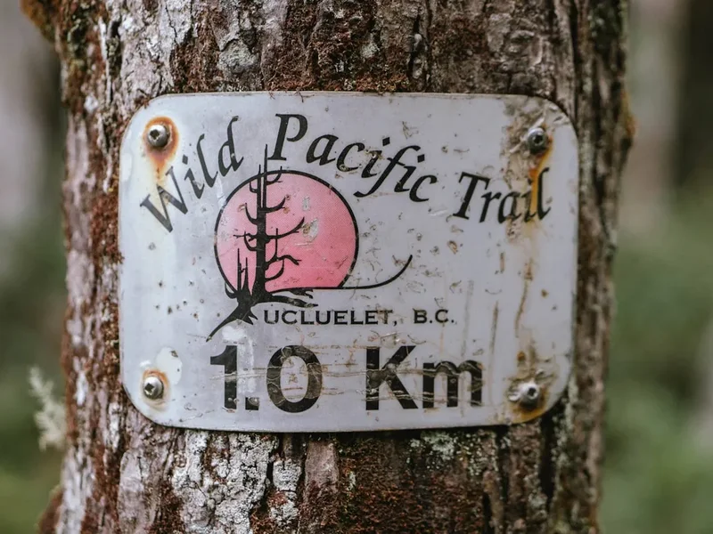
- The Wild Pacific Trail: For those who want coastal views without the 75km commitment, this trail in Ucluelet offers stunning vistas of the Broken Group Islands and the rugged shoreline.
- Kayaking the Broken Group Islands: Part of the Pacific Rim National Park Reserve, this archipelago is a paradise for sea kayakers, offering sheltered waters and abundant marine life.
- Hot Springs Cove: Accessible by boat or floatplane from Tofino, these natural geothermal pools are located in a remote provincial park.
- Bamfield Exploration: Visit the remote village of Bamfield, near the northern trailhead, to see the historic cable station and the Bamfield Marine Sciences Centre.
Safety and Conditions
Tide Awareness: The single greatest hazard on the Pacific Rim Trail is the tide. Several sections of the beach are completely submerged at high tide, and surge channels can become impassable or deadly. Hikers are provided with a tide table and must learn how to read it. Always plan your beach sections to coincide with a falling tide, and never attempt to "race" the tide around a headland. If in doubt, use the forest bypass trails, even if they are muddier and more difficult.
Wildlife Encounters: The trail is home to black bears, cougars, and wolves. While attacks are extremely rare, hikers must be "wildlife aware." This means making noise while hiking to avoid surprising an animal, keeping a clean campsite, and storing all food and scented items (including toothpaste and sunscreen) in the provided bear lockers. Never feed wildlife, and maintain a respectful distance of at least 100 metres from any large predator.
Ladders and Technical Terrain: The ladders are a signature feature of the trail but require focus and care. Always maintain three points of contact, and take your time, especially when it is raining. Slippery roots and "greasy" boardwalks are common causes of ankle and knee injuries. Trekking poles are highly recommended for stability in the mud and on uneven ground.
Hypothermia: Even in summer, the combination of rain, wind, and cold coastal temperatures can lead to hypothermia. Always have a set of dry clothes sealed in a waterproof bag, and put on your rain gear before you get soaked. If you become wet and cold, stop, find shelter, and change into dry layers immediately.
Emergency Evacuation: There is no road access to the trail. In the event of a serious injury, evacuation is typically conducted by Parks Canada via boat or helicopter. This is an expensive and logistically complex process. Hikers should carry a satellite communication device and be prepared to wait several hours or even a day for rescue depending on weather conditions.
Side Trips and Points of Interest
Tsusiat Falls: While this is a standard campsite, it is also the trail's most famous landmark. The falls are a perfect place to spend an afternoon swimming in the pool at the base or exploring the sea caves nearby. At low tide, you can walk behind the curtain of water.
Carmanah Point Lighthouse: Built in 1891, this lighthouse is a beautiful example of maritime architecture. The keepers are often happy to chat with hikers and share stories about the ships that have passed by. The view from the cliffs here is one of the best on the trail.
The Hole-in-the-Wall: Located near Tsusiat Point, this natural rock arch is a popular photo spot. It is only accessible at lower tides, so check your tables before heading out.
Nitinaht Narrows Crab Shack: While technically a commercial enterprise, the "Crab Shack" is a legendary stop. Run by the local Ditidaht First Nation, it offers fresh-caught Dungeness crab and salmon. It is a welcome break from dehydrated trail food and a great place to meet other hikers.
Sea Lion Haul-out: Near the Pachena Point Lighthouse, there is a rocky outcrop where hundreds of Steller and California sea lions often gather. The sound of their barking can be heard from kilometres away, and they are a spectacular sight through binoculars.
Leave No Trace
The Pacific Rim Trail is a fragile ecosystem that faces significant pressure from human use. To ensure the trail remains pristine for future generations, all hikers must strictly adhere to "Leave No Trace" principles. The park's management takes these rules seriously, and wardens frequently patrol the trail to ensure compliance.
Key Principles for the Coast:
- Pack it in, pack it out: This includes all food scraps, orange peels, and hygiene products. There are no rubbish bins on the trail.
- Respect the Bear Lockers: Use them for everything that has a scent. This prevents habituating bears to human food, which ultimately protects the animals.
- Dispose of Waste Properly: Use the provided pit toilets. If you are caught between campsites, bury human waste in a hole 15–20 cm deep at least 70 metres from any water source or the trail.
- Minimise Fire Impact: Only build fires on the beach below the high-tide line using small pieces of driftwood. Never build fires in the forest or on the forest fringe. Ensure fires are completely extinguished with water before leaving.
- Stay on the Trail: In the forest, stay on the boardwalks and established paths to avoid trampling sensitive vegetation and widening mud holes.
- Leave What You Find: Do not collect shells, rocks, or historical artefacts. The shipwreck remains are protected by law; leave them where they lie.