Pacific Northwest Trail - From the Continental Divide to the Pacific Ocean
The Pacific Northwest Trail (PNT) is one of the most diverse and challenging long-distance hiking routes in North America—a 1,931.2 km odyssey that traverses the rugged landscapes of the northwestern United States. Stretching from the towering peaks of the Continental Divide in Glacier National Park, Montana, to the wild, driftwood-strewn shores of the Pacific Ocean in Olympic National Park, Washington, this trail offers a profound immersion into the wilderness of the American West. Unlike more established routes, the PNT is a "connector" trail, weaving together a tapestry of existing hiking trails, remote forest roads, and demanding cross-country bushwhacking sections. It crosses three states—Montana, Idaho, and Washington—and navigates through seven National Forests and three National Parks, offering a journey that is as much about navigation and self-reliance as it is about physical endurance.
- Distance: 1,931.2 km one-way
- Duration: 60–90 days (2–3 months)
- Season: Late June to September (highly dependent on snowpack and fire conditions)
- Highest point: Cathedral Pass (2,393 m)
- Difficulty: Very Challenging (requires advanced navigation and wilderness skills)
- Direction: Eastbound or Westbound (Westbound is most common to follow the snowmelt)
- Total Elevation Gain: 67,056 m
Overview
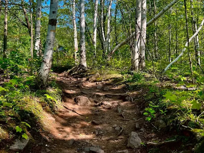
The Pacific Northwest Trail is often described as the "thinking person's thru-hike." While the Pacific Crest Trail and Appalachian Trail offer well-trodden paths and consistent marking, the PNT demands a higher level of engagement with the landscape. The route is a masterclass in ecological diversity, transitioning from the high alpine glaciers and grizzly-inhabited valleys of the Rocky Mountains to the arid, sun-drenched Okanogan Highlands, and finally into the moss-draped temperate rainforests and rugged coastline of the Olympic Peninsula. It is a trail of contrasts, where a morning spent navigating a scree slope at 2,000 metres can end with a descent into a lush river valley filled with ancient cedar trees.
The PNT is not a single, continuous footpath but a corridor of adventure. Approximately one-third of the route consists of established hiking trails, one-third follows remote forest service roads, and the final third involves cross-country travel or "bushwhacking" through dense vegetation. This variety requires hikers to be proficient in map and compass navigation, as well as GPS usage. The trail's character is defined by its solitude; while the "Triple Crown" trails see thousands of hikers annually, the PNT remains a quiet alternative, where you may go days without seeing another soul. This isolation provides a rare opportunity for genuine wilderness immersion, but it also means that self-sufficiency is paramount. There are no "trail angels" waiting at every road crossing, and resupply points can be over 150 kilometres apart.
The physical demands of the PNT are significant. With over 67,000 metres of elevation gain, the trail is a relentless series of climbs and descents. Hikers must contend with the "PNT brush"—thick stands of slide alder and devil's club that can slow progress to less than a kilometre per hour. However, the rewards are commensurate with the effort. From the sight of a grizzly bear foraging in a Montana meadow to the sound of the Pacific surf crashing against sea stacks at the journey's end, the PNT offers a sequence of "once-in-a-lifetime" moments that define the true spirit of exploration.
History and Cultural Context
The Pacific Northwest Trail was the brainchild of Ron Strickland, an explorer and visionary who first conceived of a route connecting the Rockies to the Pacific in the early 1970s. Strickland's goal was to create a trail that showcased the unique beauty of the Northwest while providing a more rugged and remote experience than the existing National Scenic Trails. For decades, the PNT existed as a grassroots project, maintained by a dedicated group of volunteers and the Pacific Northwest Trail Association (PNTA). It wasn't until 2009 that the trail received official recognition, when it was designated by Congress as a National Scenic Trail, joining the ranks of the PCT and the AT.
The history of the land the PNT traverses is far older than the trail itself. The route passes through the ancestral territories of numerous Indigenous peoples, including the Blackfeet, Kootenai, Salish, Pend d'Oreille, Kalispel, Colville, Okanogan, Yakima, Coast Salish, Quileute, and Makah. For thousands of years, these nations have lived in harmony with these landscapes, utilizing the mountain passes for trade and the river valleys for sustenance. The PNT follows many ancient travel routes, and hikers are encouraged to walk with respect for the deep cultural heritage of the region. The trail also reflects the more recent history of the American West, passing through former mining districts, timber lands, and historic homesteads that tell the story of the region's industrial and agricultural development.
Today, the PNT is managed through a partnership between the U.S. Forest Service, the National Park Service, and the PNTA. The trail continues to evolve, with ongoing efforts to move the route off roads and onto permanent footpaths. Walking the PNT is not just a physical journey; it is a way to connect with the complex history of the American Northwest, from its ancient geological origins to its modern-day conservation challenges.
Want more background? Read extended notes on history and cultural context → Learn more
Seasonal Highlights and Weather Reality
The window for a successful PNT thru-hike is narrow, dictated primarily by snow levels in the high mountains and the onset of the autumn storms. Most hikers begin their journey in late June or early July, depending on the previous winter's snowpack. Starting too early can mean facing dangerous snow slopes and swollen, impassable river crossings, particularly in the Rocky Mountains and the North Cascades. Conversely, starting too late increases the risk of being caught by early winter snows in the Olympic Mountains or facing the peak of the wildfire season.
Summer (July and August) is the prime hiking season. In the eastern sections, temperatures can be pleasantly warm, though high-altitude camps can still drop below freezing at night. The Okanogan Highlands can be surprisingly hot and dry, requiring careful water management. This is also the season of the "Northwest mosquito," which can be prolific in damp areas. August often brings the threat of wildfires; smoke can obscure views and, in some cases, lead to trail closures and mandatory detours. Hikers must stay informed about fire conditions and be prepared to change their plans at short notice.
September offers some of the best hiking conditions, with crisp air, fewer insects, and the stunning autumn colours of the huckleberry bushes and larch trees. However, the days become shorter, and the weather becomes more unpredictable. On the Olympic Peninsula, September marks the beginning of the rainy season. The "Liquid Sunshine" of the Pacific Northwest is no joke; hikers can experience days of relentless rain, which transforms the trail into a muddy challenge and makes staying warm and dry a full-time job. Snow can fall on the high passes as early as mid-September, potentially ending a thru-hike prematurely for those who haven't reached the coast.
Recommended Itinerary
The 12 Sections of the Pacific Northwest Trail
Section 1: Glacier National Park (The Rockies)
- Distance: 200 km
- Key Waypoints: Chief Mountain, Waterton Lake, Fifty Mountain, Polebridge
- The journey begins at the Continental Divide, traversing the spectacular "Crown of the Continent."
- Expect high alpine passes, glacial lakes, and significant grizzly bear activity.
- Permits are strictly regulated; hikers must stay at designated backcountry campsites.
- The descent into the North Fork of the Flathead River leads to the quirky town of Polebridge, famous for its huckleberry bear claws.
Section 2: The Whitefish Range
- Distance: 160 km
- Key Waypoints: Whitefish Divide, Ten Lakes Scenic Area, Bluebird Lake
- A rugged section following the crest of the Whitefish Range with expansive views into Canada.
- Features a mix of single-track trail and remote forest roads.
- The Ten Lakes Scenic Area offers some of the most beautiful alpine scenery in Montana.
- Water can be scarce on the ridges; plan carries carefully.
Section 3: The Purcells and Yaak Valley
- Distance: 180 km
- Key Waypoints: Northwest Peak, Yaak River, Garver Mountain
- The trail enters the remote Yaak Valley, one of the wildest corners of Montana.
- Expect dense forest, low-elevation river walking, and the occasional "bushwhack" through thick undergrowth.
- The town of Yaak provides a unique resupply opportunity at the Dirty Shame Saloon.
- This is prime habitat for wolves and mountain lions.
Section 4: The Selkirk Mountains
- Distance: 170 km
- Key Waypoints: Upper Priest Lake, Continental Mountain, Metaline Falls
- Crossing into Idaho, the trail climbs into the rugged Selkirk Mountains.
- Features the "Lion's Head" bushwhack, one of the most notorious sections of the PNT.
- Upper Priest Lake offers a pristine wilderness experience with crystal-clear water.
- The section ends in the historic mining town of Metaline Falls, Washington.
Section 5: The Kettle River Range
- Distance: 150 km
- Key Waypoints: Abercrombie Mountain, Columbia River, Copper Butte
- The trail crosses the Columbia River (via bridge) and enters the Kettle River Range.
- Characterised by high, rolling ridges and open ponderosa pine forests.
- Abercrombie Mountain provides 360-degree views of the surrounding ranges.
- The area is home to a growing population of grey wolves.
Section 6: The Okanogan Highlands
- Distance: 160 km
- Key Waypoints: Republic, Bonaparte Mountain, Oroville
- A transition into a drier, more arid landscape with significant road walking.
- The town of Republic is a friendly resupply stop with a rich mining history.
- Bonaparte Mountain features a historic fire lookout with incredible views.
- The descent into Oroville brings hikers to the lowest elevation on the trail east of the Cascades.
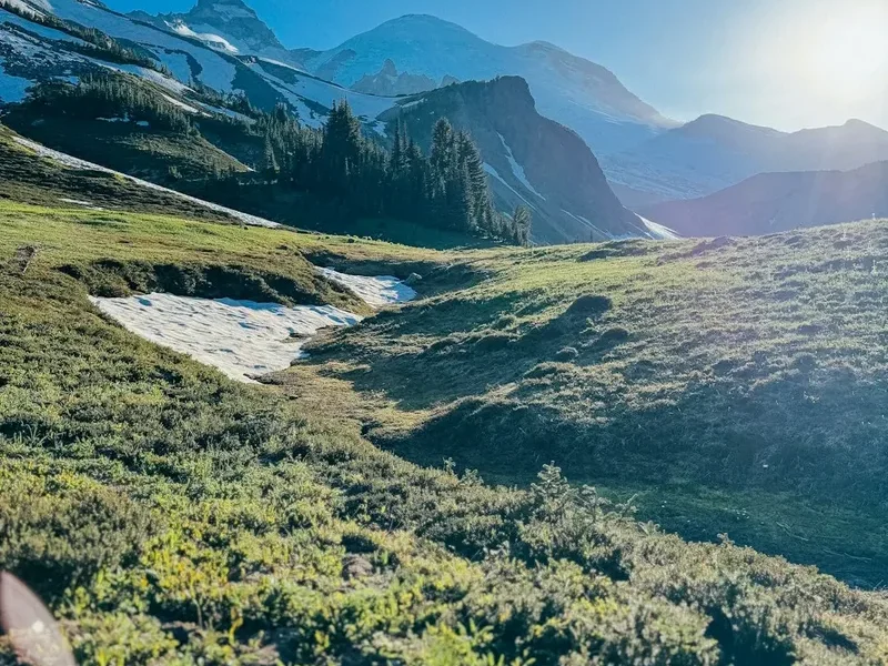
Section 7: The Pasayten Wilderness
- Distance: 170 km
- Key Waypoints: Cathedral Pass, Boundary Trail, Bunker Hill
- One of the highlights of the PNT, traversing the vast and remote Pasayten Wilderness.
- High alpine plateaus, jagged peaks, and some of the best trail conditions on the entire route.
- Cathedral Pass (2,393 m) is a stunning landmark of granite spires.
- Hikers often see mountain goats and marmots in this section.
Section 8: North Cascades National Park
- Distance: 150 km
- Key Waypoints: Ross Lake, Whatcom Pass, Chilliwack River
- A return to the "American Alps" with steep climbs and dramatic glacial scenery.
- Ross Lake involves a ferry crossing or a long shore trail.
- Whatcom Pass is famously beautiful but requires a demanding climb.
- The "Brush Creek" section is notorious for its namesake vegetation.
Section 9: The Skagit Valley and Puget Sound
- Distance: 200 km
- Key Waypoints: Baker Lake, Sedro-Woolley, Deception Pass
- The trail leaves the high mountains and follows the Skagit River towards the coast.
- Features lush lowland forests and the impressive Deception Pass Bridge.
- Hikers transition from mountain boots to "road legs" for the walk through the Skagit Valley.
- The first smell of salt air arrives as the trail reaches the shores of Puget Sound.
Section 10: The Olympic Peninsula
- Distance: 160 km
- Key Waypoints: Port Townsend, Discovery Bay, Olympic National Forest
- A mix of beach walking, rail-trails (the Olympic Discovery Trail), and forest roads.
- Port Townsend is a Victorian-era seaport and a popular "zero day" location.
- The trail gradually climbs back into the mountains of the Olympic National Forest.
- Expect damp conditions and lush, mossy forests.
Section 11: Olympic National Park
- Distance: 150 km
- Key Waypoints: Hurricane Ridge, Obstruction Point, Bogachiel River
- The final mountain challenge, traversing the heart of the Olympic Mountains.
- Hurricane Ridge offers iconic views of Mount Olympus and the surrounding glaciers.
- The descent into the Bogachiel River valley enters a true temperate rainforest.
- Navigation can be tricky in the dense, fog-prone forests.
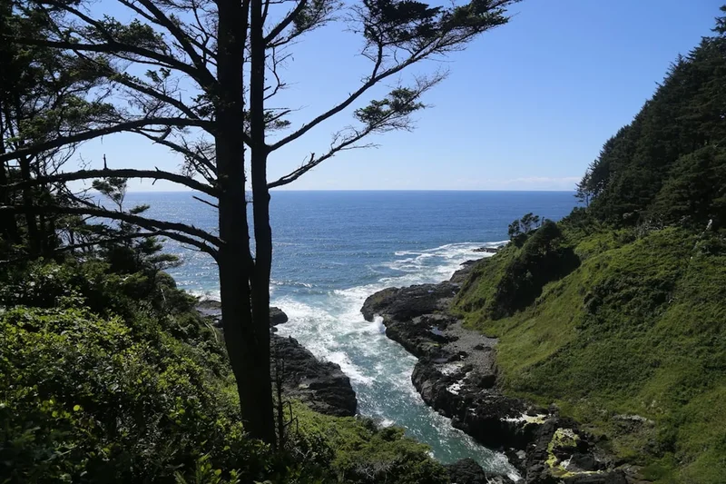
Section 12: The Pacific Coast
- Distance: 81.2 km
- Key Waypoints: Rialto Beach, Cape Alava, Cape Flattery
- The grand finale: walking the wild coastline of the Pacific Ocean.
- Requires timing tides to pass around rocky headlands safely.
- Features sea stacks, tide pools, and massive driftwood logs.
- The journey ends at Cape Flattery, the northwesternmost point of the contiguous United States.
Planning and Bookings
Book Your Trip
Everything you need to plan your journey
Accommodation
Find places to stay near Seattle, Washington
Flights
Search flights to Seattle, Washington
Essential Preparation
Planning a PNT thru-hike requires months of preparation. Unlike the PCT, there is no single permit that covers the entire trail. Hikers must coordinate permits for three different National Parks and various wilderness areas. Fitness is crucial; the PNT is physically more demanding than most other long trails due to the steepness of the terrain and the difficulty of the "bushwhack" sections. It is recommended to have several shorter multi-day hikes under your belt before attempting the PNT.
Seattle serves as the primary logistical hub for the western end of the trail, while Kalispell or Missoula, Montana, are the best bases for the eastern start. Resupply is a major consideration; many hikers use a combination of "buying as you go" in towns like Republic and Oroville, and sending "resupply boxes" to remote locations like Polebridge or the Ross Lake Resort. Navigation skills are non-negotiable; you must be comfortable using a GPS and carrying paper maps as a backup.
Trail Accommodation
Accommodation on the PNT is primarily wild camping on public lands (National Forests and BLM land). However, in National Parks, you are restricted to designated campsites which must be booked in advance.
National Park Backcountry Sites:
- Glacier NP: Requires a backcountry permit for specific sites. Facilities usually include a pit toilet and a food hanging cable.
- North Cascades NP: Requires permits for specific camps. Some sites have composting toilets.
- Olympic NP: Requires permits for both mountain and coastal sites. Bear canisters are mandatory in many areas.
Other Options:
- Forest Service Campgrounds: Scattered along the route, often with basic facilities like pit toilets and water pumps.
- Towns: Hikers typically stay in motels, hostels, or "trail angel" houses in towns like Eureka, Metaline Falls, and Port Townsend.
- Fire Lookouts: A few historic fire lookouts along the trail are available for rent through the Forest Service, though these must be booked months in advance.
Required Gear
- Footwear: Rugged trail runners or lightweight boots with excellent traction. Expect to go through 3-4 pairs.
- Navigation: A dedicated GPS device (like a Garmin inReach) and the FarOut (Guthook) app are essential. Paper maps are a mandatory backup.
- Shelter: A lightweight, storm-worthy tent or tarp. It must be able to handle high winds and heavy rain.
- Sleep System: A 3-season sleeping bag (rated to -5°C) and a high-R-value sleeping pad.
- Pack: A 50-70L backpack that can comfortably carry up to 7 days of food and 4 litres of water.
- Bear Protection: A bear-resistant canister is required in National Parks and highly recommended throughout the trail. Bear spray is essential in Montana and Idaho.
- Rain Gear: High-quality waterproof jacket and trousers. The "Pacific Northwest" rain is relentless.
What to Bring
- Food: High-calorie, lightweight meals. Aim for 3,500-4,500 calories per day.
- Water Treatment: A reliable filter (like a Sawyer Squeeze) or chemical treatment. Water sources can be silty or contaminated by livestock.
- First Aid: A comprehensive kit including blister care, antiseptic, and any personal medications.
- Sun Protection: Sunscreen, sunglasses, and a wide-brimmed hat for the exposed ridges and the Okanogan Highlands.
- Clothing: A layering system including merino wool base layers, a down or synthetic "puffy" jacket, and quick-drying hiking clothes.
- Repair Kit: Duct tape, needle and thread, and patches for your sleeping pad and tent.
- Power: A large capacity power bank (20,000mAh) to keep your GPS and phone charged between towns.
Permits
The permit system for the PNT is complex because the trail crosses multiple jurisdictions. There is no "PNT Thru-Hike Permit." Instead, you must secure individual permits for the National Parks you pass through.
Glacier National Park: Permits are required for all overnight stays. You can apply for a "General Reservation" in March, or attempt to get a "Walk-in Permit" 24 hours before your start. For thru-hikers, the walk-in option is common but risky. You must have a flexible itinerary.
North Cascades National Park: Similar to Glacier, permits are required for specific backcountry camps. These can be reserved online via Recreation.gov or obtained as walk-ins at the Marblemount Wilderness Information Centre.
Olympic National Park: Permits are required for all backcountry camping. Coastal permits are often easier to get than mountain permits, but popular areas like Seven Lakes Basin sell out quickly. Reservations open in the spring.
National Forests: Generally, no permits are required for dispersed camping in National Forests (Flathead, Kootenai, Idaho Panhandle, Colville, Okanogan-Wenatchee, Mt. Baker-Snoqualmie, and Olympic). However, you must follow all local fire restrictions and "Leave No Trace" principles.
Other Activities in the Area
If you have extra time or are looking for a break from the trail, the Pacific Northwest offers incredible opportunities:
- Whale Watching: From Port Townsend or Anacortes, take a boat tour to see Orcas, Humpbacks, and Grey Whales in the Salish Sea.
- Mount Baker: For those with mountaineering skills, a summit attempt of this 3,286 m active volcano offers a world-class alpine experience.
- Hot Springs: Visit Sol Duc Hot Springs in Olympic National Park for a soak in natural mineral pools after weeks on the trail.
- Craft Breweries: The Northwest is famous for its beer. Towns like Whitefish, Republic, and Port Townsend have excellent local breweries.
- Kayaking: Rent a kayak on Ross Lake or in the San Juan Islands to experience the region's stunning waterways from a different perspective.
Safety and Conditions
The PNT is a serious undertaking that presents several significant hazards. Being prepared and informed is the key to a safe journey.
Wildlife: The eastern half of the trail is grizzly bear country. Hikers must carry bear spray, know how to use it, and practice strict food storage protocols. Black bears are common throughout the entire trail. Mountain lions and wolves are also present but rarely encountered. Rattlesnakes may be found in the drier sections of the Okanogan Highlands.
Navigation: As mentioned, the PNT is not always a clear path. Bushwhacking through dense vegetation can lead to disorientation. Always carry a GPS with the latest route data and know how to use a map and compass. Cell phone service is non-existent for long stretches.
Water: While water is generally abundant, some ridge sections in the Whitefish and Kettle Ranges can be dry for 20-30 kilometres. In the Okanogan, some water sources may be shared with cattle and require thorough filtration. Always check the latest water reports from other hikers on the FarOut app.
Weather and Fire: Hypothermia is a risk even in summer if you get wet and cold in the mountains. Wildfires are a major concern in August and September. Always have an exit strategy and stay updated on fire closures via the PNTA website or local Ranger Stations.
Side Trips and Points of Interest
The PNT corridor is full of hidden gems that are worth the extra kilometres:
Cathedral Peak: Located in the Pasayten Wilderness, this iconic granite spire is a magnet for climbers and photographers. A short scramble from the trail offers incredible views of the surrounding wilderness.
The Dirty Shame Saloon: In the tiny town of Yaak, Montana, this legendary establishment is a rite of passage for PNT hikers. It offers a glimpse into the unique culture of the "Yaak."
Deception Pass: The bridge over Deception Pass is one of the most photographed spots in Washington. Take the time to explore the state park's trails and watch the powerful tidal currents surge through the narrow gap.
Cape Flattery: The official end of the trail. The short walk to the overlooks provides a dramatic conclusion to the journey, with views of Tatoosh Island and the vast Pacific Ocean.
Leave No Trace

The PNT passes through some of the most pristine and fragile ecosystems in the United States. It is the responsibility of every hiker to minimise their impact.
- Plan Ahead and Prepare: Know the regulations for each area and be prepared for the conditions.
- Travel and Camp on Durable Surfaces: Use established campsites where possible. In "bushwhack" sections, spread out to avoid creating new social trails.
- Dispose of Waste Properly: Pack out all trash, including food scraps and toilet paper. Use cat holes at least 15 cm deep and 60 metres from water.
- Leave What You Find: Do not disturb historic sites or remove plants and rocks.
- Minimise Campfire Impacts: Use a stove for cooking. Only build fires in established rings where permitted, and always check fire restrictions.
- Respect Wildlife: Observe from a distance and never feed animals. Store food securely to prevent habituation.
- Be Considerate of Other Visitors: Keep noise levels down and yield to other trail users.