Pacific Crest Trail - A Journey Across the American West
The Pacific Crest Trail (PCT) is one of the most iconic long-distance hiking routes on Earth, stretching 4,270 kilometres from the Mexican border to the Canadian border. This monumental journey traverses the entire height of the United States, passing through the states of California, Oregon, and Washington. It is a trail of immense diversity, leading walkers through the arid, sun-scorched Mojave Desert, over the jagged, snow-capped granite spires of the High Sierra, and through the lush, volcanic landscapes of the Pacific Northwest. For those who attempt the full "thru-hike," the PCT is more than just a walk; it is a four-to-six-month odyssey that tests physical endurance, mental fortitude, and the ability to adapt to some of the most varied environments in North America.
- Distance: 4,270.0 km
- Elevation Gain: 149,000 m
- Duration: 4–6 months
- Difficulty: Very Challenging
- Best Time: Late April to September (Southbound), Late June to October (Northbound)
- Highest Point: Forester Pass (4,009 m)
- Lowest Point: Cascade Locks, Oregon (43 m)
- States Traversed: California, Oregon, Washington
Overview
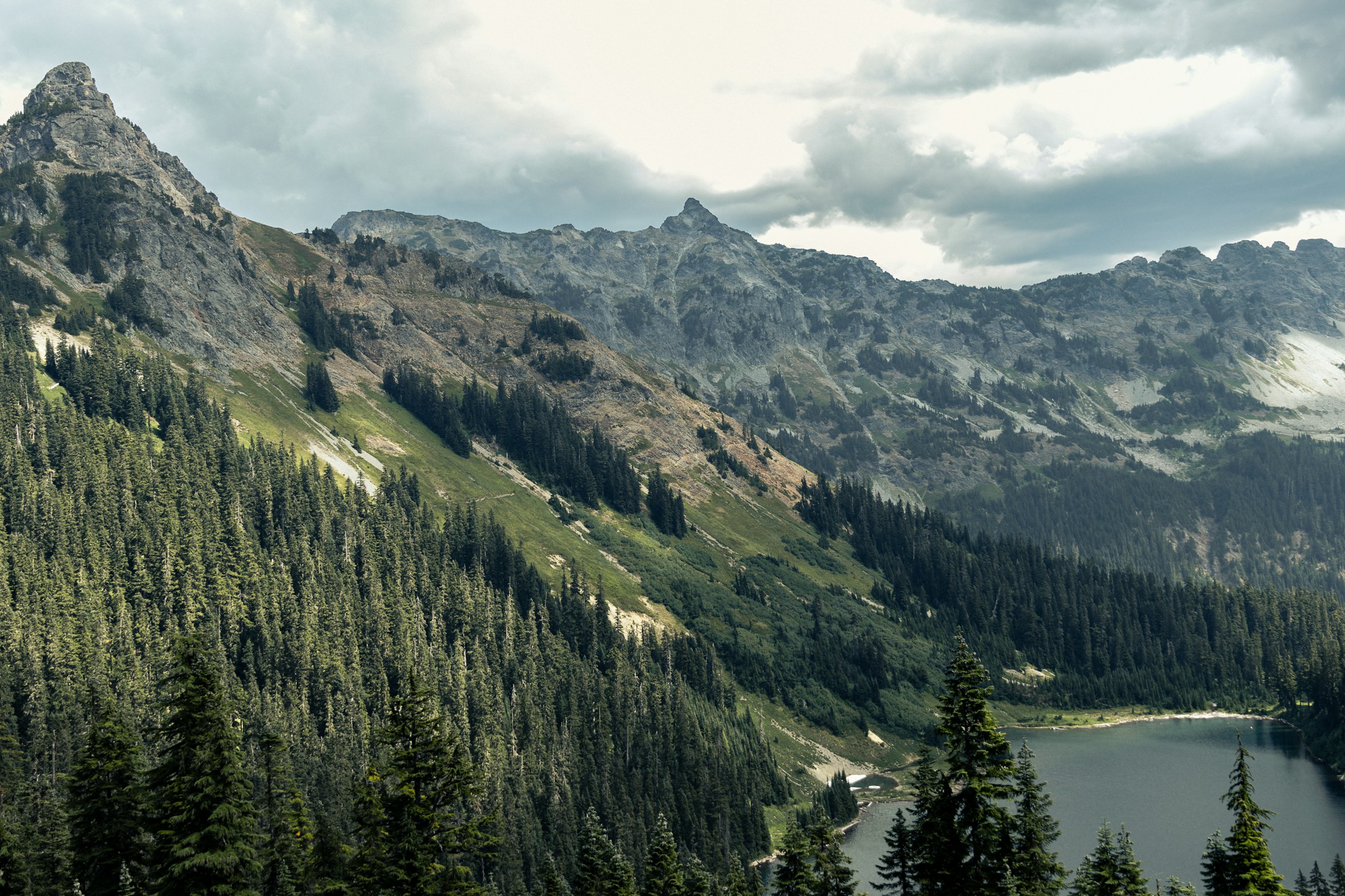
The Pacific Crest Trail is a masterclass in ecological transition. It begins at the Southern Terminus in Campo, California, where the landscape is dominated by chaparral, sagebrush, and the relentless heat of the desert. As hikers move north, the trail ascends into the San Jacinto and San Bernardino Mountains before dropping back into the Mojave. The true heart of the trail, for many, is the High Sierra. Here, the path stays almost entirely above 3,000 metres for hundreds of kilometres, crossing high alpine passes and skirting pristine glacial lakes. This section includes the highest point on the trail, Forester Pass, and offers the opportunity to summit Mount Whitney, the highest peak in the contiguous United States, via a short side trip.
North of the Sierra, the trail enters Northern California, a region of deep forests and volcanic features, including the striking Mount Lassen and Mount Shasta. Crossing into Oregon, the terrain becomes noticeably flatter and more forested, though no less spectacular. The trail passes through the Cascade Range, featuring the deep blue waters of Crater Lake and the iconic peaks of Mount Hood and Mount Jefferson. Finally, the trail enters Washington, often considered the most rugged and scenic portion of the entire route. The North Cascades offer steep climbs, dramatic ridgelines, and a temperate rainforest environment that feels worlds away from the California desert. The journey concludes at the Northern Terminus on the Canadian border, usually followed by a 13-kilometre walk into Manning Park, British Columbia.
Walking the PCT is a lesson in scale. The elevation gain of 149,000 metres is equivalent to climbing Mount Everest from sea level nearly 17 times. Hikers must manage extreme temperature fluctuations, from 40°C in the desert to sub-zero temperatures in the mountains. Water management is a critical skill in the south, while snow navigation and river crossings dominate the central sections. Despite these challenges, the trail offers a profound sense of community. The "PCT family" of hikers, trail angels, and volunteers creates a unique social fabric that supports walkers through the most difficult stretches of the journey.
History and Cultural Context
The concept of a continuous trail along the crest of the Pacific mountains was first proposed in the 1920s. Clinton Churchill Clarke, a scout leader and outdoorsman, is often credited as the "Father of the PCT." In 1932, he organised the Pacific Crest Trail System Conference to lobby for a border-to-border trail. Throughout the 1930s, teams of YMCA hikers scouted and mapped sections of the route, proving that a continuous path was feasible. However, it wasn't until the mid-20th century that the trail gained formal federal recognition.
In 1968, President Lyndon B. Johnson signed the National Trails System Act, which designated the Pacific Crest Trail and the Appalachian Trail as the first National Scenic Trails in the United States. This act provided the legal framework and funding necessary to secure the right-of-way and begin formal construction and maintenance. The trail was officially completed in 1993, though "completion" is a relative term; the trail is constantly being refined, rerouted around private land, or repaired following wildfires and landslides.
Before the arrival of European settlers and the formal designation of the trail, the land it traverses was—and remains—the ancestral home of numerous Indigenous peoples. The trail passes through the traditional territories of the Kumeyaay, Cahuilla, Serrano, Kawaiisu, Mono, Washoe, Maidu, Modoc, Klamath, Warm Springs, Yakima, and many other nations. These groups used the mountain passes for trade, hunting, and spiritual practices for millennia. Recognising this history is an essential part of the modern PCT experience, as hikers move through landscapes that have been managed and inhabited by humans for over 10,000 years.
Want more background? Read extended notes on history and cultural context → Learn more
Seasonal Highlights and Weather Reality
Timing is everything on the Pacific Crest Trail. The "window" for a successful thru-hike is dictated by two primary factors: the desert heat in the south and the snowpack in the mountains. Most Northbound (NOBO) hikers begin in late April or early May to ensure they reach the Sierra after the spring snowmelt has begun but before the desert becomes dangerously hot. Southbound (SOBO) hikers typically start in late June or early July, waiting for the snow in the North Cascades to melt sufficiently to allow passage.
Spring (April–June): For NOBO hikers, this is the desert season. Wildflowers can be spectacular in the Mojave if there has been sufficient winter rain. However, water sources are scarce, and temperatures can soar. In the High Sierra, this is the "shoulder" season where hikers may encounter significant snow on the passes, requiring ice axes and microspikes.
Summer (July–August): This is the peak hiking season. The Sierra is usually clear of deep snow, and the meadows of Oregon and Washington are in full bloom. However, this is also the height of "mosquito season" in the Cascades, which can be a significant mental challenge. More importantly, this is the peak of the wildfire season. In recent years, large sections of the trail have been closed due to active fires or smoke, requiring hikers to skip sections or wait for conditions to improve.
Autumn (September–October): The days become shorter and the nights significantly colder. For NOBO hikers finishing in Washington, the threat of early winter storms is a constant concern. A single heavy snowstorm in the North Cascades can effectively end a thru-hike attempt. Conversely, the autumn colours in the Pacific Northwest are breathtaking, and the huckleberries are ripe for picking along the trail.
Recommended Itinerary
The Five Sections of the PCT
Section 1: Southern California (The Desert)
- Distance: 1,129 km
- Key Waypoints: Campo, Lake Morena, Mount Laguna, Warner Springs, Idyllwild, Big Bear Lake, Wrightwood, Agua Dulce, Tehachapi
- Terrain: Arid chaparral, high desert ridges, and pine-forested islands
- Challenges: Long water carries (up to 30 km), extreme heat, and the "Tehachapi Wind Farms"
- Highlights: The Eagle Rock formation, the San Jacinto climb, and the iconic Vasquez Rocks
- Average Time: 6–8 weeks
Section 2: Central California (The High Sierra)
- Distance: 812 km
- Key Waypoints: Kennedy Meadows (South), Forester Pass, Kearsarge Pass (resupply), Muir Pass, Selden Pass, Red's Meadow, Tuolumne Meadows, Sonora Pass
- Terrain: High alpine granite, glacial basins, and sub-alpine forests
- Challenges: High altitude (mostly above 3,000 m), snow navigation, and dangerous river crossings during melt
- Highlights: Forester Pass (4,009 m), the Evolution Basin, and the proximity to Mount Whitney
- Average Time: 4–6 weeks
Section 3: Northern California
- Distance: 912 km
- Key Waypoints: Sierra City, Belden, Chester, Lassen Volcanic National Park, Burney Falls, Mount Shasta, Etna, Seiad Valley
- Terrain: Volcanic landscapes, deep river canyons, and dense coniferous forests
- Challenges: Significant elevation changes ("The Roller Coaster"), heat in the canyons, and long distances between resupply points
- Highlights: Burney Falls, the Marble Mountain Wilderness, and views of the massive Mount Shasta
- Average Time: 5–7 weeks
Section 4: Oregon
- Distance: 732 km
- Key Waypoints: Ashland, Crater Lake National Park, Shelter Cove, Elk Lake, Big Lake Youth Camp, Mount Hood, Cascade Locks
- Terrain: Relatively flat volcanic plateaus, dense forest, and iconic volcanic peaks
- Challenges: Mosquitoes in July, limited water on the lava beds, and the temptation to "speed hike" through the easier terrain
- Highlights: Crater Lake (the deepest lake in the USA), the Three Sisters Wilderness, and the Timberline Lodge on Mount Hood
- Average Time: 3–4 weeks
Section 5: Washington
- Distance: 814 km
- Key Waypoints: Bridge of the Gods, Trout Lake, White Pass, Snoqualmie Pass, Stevens Pass, Stehekin, Northern Terminus
- Terrain: Rugged alpine ridges, temperate rainforest, and steep glacial valleys
- Challenges: Unpredictable weather, steep climbs and descents, and the logistical challenge of the final stretch to the border
- Highlights: The Goat Rocks Wilderness (Knife's Edge), Glacier Peak Wilderness, and the remote beauty of the North Cascades
- Average Time: 4–6 weeks
Important Notes:
- Resupply is typically managed through a combination of "mailing boxes" to post offices and buying food in trail towns.
- The "Halfway Point" is located near Chester, California, though the exact location shifts slightly with trail reroutes.
- Most hikers aim for an average of 25–35 km per day, though "marathon days" (42 km) become common in Oregon.
- The trail ends at the border, but hikers must walk an additional 13 km into Canada to reach transport at Manning Park.
Planning and Bookings
Book Your Trip
Everything you need to plan your journey
Accommodation
Find places to stay near Campo
Flights
Search flights to Campo
Essential Preparation
Planning a PCT thru-hike is a massive undertaking that usually begins a year in advance. Physical preparation is vital; while you will "walk yourself into shape" on the trail, having a baseline of cardiovascular fitness and leg strength will prevent early injuries like stress fractures or tendonitis. Training should include hiking with a weighted pack and stretching routines to maintain flexibility.
Logistical preparation involves deciding on a resupply strategy. Many hikers use the "FarOut" (formerly Guthook) app, which provides real-time data on water sources, campsites, and town services. You must also decide whether to send yourself resupply boxes or "buy as you go." Most hikers use a hybrid approach, mailing boxes to remote locations with limited stores (like Stehekin or Kennedy Meadows) and buying food in larger towns like Ashland or Bishop.
Base cities for the start of the trail include San Diego (for NOBO) and Seattle or Vancouver (for SOBO). San Diego is the most common starting point, with "Trail Angels" often providing transport from the airport to the Southern Terminus in Campo.
Trail Accommodation
The vast majority of nights on the PCT are spent in a tent. Unlike European trails or New Zealand's Great Walks, there is no system of huts or lodges along the route. Hikers must be self-sufficient and comfortable with "stealth camping" or using established backcountry campsites.
Camping Facilities:
- Established campsites: Often just a flat piece of ground with a pre-existing fire ring (though fires are frequently banned).
- Water access: Campsites are usually located near water sources, though in the desert, you may have to camp "dry" (carrying all water for the night).
- Pit toilets: Available only in high-use areas like National Parks or near trailheads; otherwise, hikers must dig cat holes.
- Bear lockers: Provided in some high-activity areas in the Sierra and National Parks.
Town Accommodation:
- Motels and Hotels: Common in trail towns, though they can be expensive during peak season.
- Hostels: Several dedicated hiker hostels exist (e.g., in Wrightwood or Big Bear).
- Trail Angel Houses: Some locals open their homes to hikers for a donation or for free, providing a bed, shower, and laundry.
- Costs: Budget approximately US$1,000–$1,500 per month for food, town stays, and gear replacements.
Required Gear
- Ultralight Tent or Shelter - Must be wind-resistant and bug-proof (especially for the Cascades).
- Backpack - 40–60L capacity, properly fitted to your torso length.
- Sleeping System - A quilt or sleeping bag rated to at least -7°C (-6°C) and an insulated sleeping pad.
- Footwear - Most modern PCT hikers use trail running shoes rather than heavy boots. Expect to go through 4–5 pairs.
- Bear Canister - Mandatory in the Sierra Nevada and parts of Washington to protect food from bears.
- Ice Axe and Microspikes - Essential for the High Sierra and North Cascades if travelling in early summer.
- Navigation - Smartphone with FarOut app, backup power bank, and a paper map/compass for emergencies.
- Satellite Messenger - Devices like the Garmin inReach are highly recommended for emergency communication in areas without mobile signal.
What to Bring
- Water Treatment - A hollow-fibre filter (like the Sawyer Squeeze) is the industry standard. Chemical tablets as backup.
- Cooking System - Lightweight canister stove (e.g., Jetboil or MSR Pocket Rocket) and a titanium pot.
- Clothing Layers - Merino wool base layers, a "puffy" down jacket for cold evenings, and a lightweight rain shell.
- Sun Protection - Wide-brimmed hat, polarised sunglasses, and sun hoodie (essential for the desert).
- First Aid and Hygiene - Blister kits, ibuprofen, hand sanitiser, and a "trowel" for digging cat holes.
- Food - High-calorie, lightweight options: oatmeal, tortillas, peanut butter, dehydrated meals, and plenty of snacks.
- Water Storage - Capacity to carry up to 6 litres for long desert stretches (using SmartWater bottles or bladders).
Permits
Because of the trail's popularity, the Pacific Crest Trail Association (PCTA) manages a centralised permit system to protect the environment from overcrowding. If you plan to hike more than 800 kilometres (804.7 km) in a single trip, you can apply for a "Long-distance Permit."
The Permit Lottery:
- The PCTA issues only 50 permits per day for Northbound hikers starting at the Mexican border.
- The lottery typically occurs in two rounds: one in mid-November and another in early January.
- Registration for the lottery happens weeks in advance; you must have a registered account to participate.
- Permits are free, but they are highly competitive and often "sell out" within hours of the lottery opening.
Local Permits:
- If you do not secure a long-distance permit, you must piece together individual permits for every National Park, National Forest, and Wilderness Area you pass through. This is logistically difficult and not recommended for thru-hikers.
- A separate "California Fire Permit" is required for using a stove in California; this is available online for free after watching a short safety video.
- A "Canada PCT Entry Permit" is required if you intend to cross the border into Canada at the end of the trail. This must be applied for months in advance. Note: You cannot legally enter the USA from Canada via the PCT.
Whitney Portal: If you intend to exit the trail via Whitney Portal (rather than returning to the PCT after summiting Mount Whitney), you need a specific permit from the Inyo National Forest, as the standard PCT permit does not cover this exit.
Other Activities in the Area
The PCT passes through some of the most spectacular protected lands in the USA. Many hikers take "zeros" (rest days) to explore nearby attractions:
- Mount Whitney Summit: A 13-km round trip from the PCT. At 4,421 m, it is the highest point in the lower 48 states and offers an unparalleled view of the Sierra.
- Yosemite Valley: While the PCT passes through the high country of Yosemite (Tuolumne Meadows), many hikers take a bus down into the main valley to see El Capitan and Half Dome.
- Crater Lake Boat Tours: In Oregon, you can hike down to the water's edge of the caldera and take a boat tour of Wizard Island.
- Columbia River Gorge: At the Oregon/Washington border, the trail crosses the Bridge of the Gods. The surrounding gorge offers world-class windsurfing, waterfalls (like Multnomah Falls), and craft breweries.
- Stehekin: A remote village in Washington accessible only by foot, boat, or floatplane. It is famous for its bakery and serves as a final sanctuary before the push to the Canadian border.
- Hot Springs: The trail passes near several natural hot springs, including Deep Creek Hot Springs in Southern California and Umpqua Hot Springs in Oregon.
Safety and Conditions
Pre-Departure Checks:
- Check the PCTA "Trail Conditions" page for active wildfire closures or bridge washouts.
- Monitor the Postel Snow Graph for the Sierra Nevada to gauge snow levels.
- Ensure your satellite messenger subscription is active and your emergency contacts have your itinerary.
- Check the "Water Report" (a crowd-sourced document) for the desert sections to ensure your planned water stops are still flowing.
Environmental Hazards: The PCT presents a wide array of natural risks. In the south, heatstroke and dehydration are the primary concerns. In the Sierra, the danger shifts to high-altitude sickness, lightning strikes on exposed ridges, and treacherous river crossings. During high snow years, creeks that are usually ankle-deep can become raging torrents capable of sweeping a hiker away. Always cross at the widest, shallowest point and unbuckle your pack's waist belt.
Wildfire: This is the most significant threat to a modern PCT thru-hike. Smoke can cause severe respiratory issues, and fires can move faster than a human can run. If you see smoke or fire, do not "wait and see." Head for the nearest trailhead or exit point. Always obey trail closures; they are in place for your safety and the safety of emergency responders.
Wildlife: The trail is home to black bears, mountain lions, and rattlesnakes. While attacks are extremely rare, proper food storage is essential to prevent bears from becoming habituated to human food. In Southern California, always check under logs and rocks for rattlesnakes, and never put your hands or feet where you cannot see.
Giardia and Cryptosporidium: These waterborne parasites are present in many water sources along the trail. Always treat your water, even if it looks pristine. A simple filter or chemical treatment is sufficient to prevent weeks of illness.
Side Trips and Points of Interest
The Knife's Edge (Goat Rocks Wilderness): Located in Washington, this is arguably the most spectacular section of the entire trail. The path follows a narrow, rocky ridgeline with steep drop-offs on both sides, offering views of Mount Rainier, Mount Adams, and Mount St. Helens. It is a high-alpine experience that requires steady nerves and clear weather.
Devils Postpile National Monument: A short walk from the trail near Red's Meadow, this geological wonder features 18-metre-high basalt columns that formed 100,000 years ago. The symmetry of the hexagonal columns is a striking example of volcanic forces.
The Bridge of the Gods: This cantilever bridge spans the Columbia River between Oregon and Washington. It marks the lowest point on the trail and is a significant psychological milestone for thru-hikers. Walking across the metal grate with the river rushing 40 metres below is a memorable (and slightly terrifying) experience.
Mount Hood Timberline Lodge: Built in the 1930s, this National Historic Landmark sits directly on the trail. It is famous for its "all-you-can-eat" hiker breakfast and its role as the exterior of the hotel in the film *The Shining*. It is a rare moment of luxury on an otherwise rugged journey.
Vasquez Rocks: These tilted sandstone formations in Agua Dulce are a famous filming location for Hollywood movies and television shows (most notably *Star Trek*). The trail winds directly through the jagged rocks, providing a surreal, desert landscape.
Leave No Trace
With thousands of hikers traversing the PCT every year, the cumulative impact on the environment is significant. Following Leave No Trace (LNT) principles is not just a suggestion; it is a requirement for the trail's survival. The PCT passes through fragile alpine tundra and arid desert crusts that can take centuries to recover from damage.
Core LNT Principles for the PCT:
- Dispose of Waste Properly: Dig a cat hole 15–20 cm deep and at least 60 metres from water sources. Pack out all toilet paper; do not bury it, as animals often dig it up.
- Respect Wildlife: Never feed animals. Use a bear canister where required and store all "smellables" (including toothpaste and sunscreen) inside it.
- Travel and Camp on Durable Surfaces: Stay on the maintained trail. Do not cut switchbacks, as this causes severe erosion. Camp on established sites rather than creating new ones.
- Leave What You Find: Do not pick wildflowers or remove rocks or artefacts. This includes "trail magic" left by others—if you find a cache, take only what you need and leave the area clean.
- Minimise Campfire Impacts: Use a stove for cooking. Campfires are discouraged and often legally banned across most of the trail due to the extreme risk of wildfire.
- Be Considerate of Others: Keep noise levels down. Many people hike the PCT for solitude. Yield to uphill hikers and pack animals (horses and mules).