The Overland Track - Australia's Premier Alpine Wilderness Journey
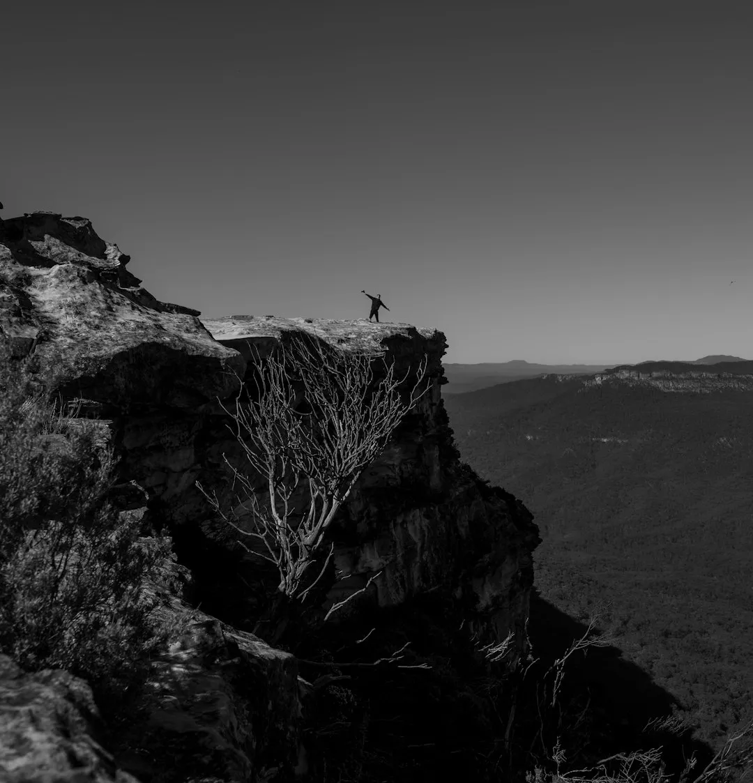
The Overland Track is Australia's most famous multi-day bushwalk, a 65-kilometre odyssey through the heart of the Tasmanian Wilderness World Heritage Area. Traversing from the iconic jagged peaks of Cradle Mountain in the north to the deep glacial waters of Lake St Clair (Leeawuleena) in the south, this journey is a profound immersion into a landscape shaped by ancient glaciers and volcanic activity. Over five to six days, walkers transition through a staggering variety of ecosystems: from windswept alpine moors and button grass plains to prehistoric rainforests of Myrtle Beech and towering stands of Eucalypt. This is not merely a hike; it is a pilgrimage through one of the last true wildernesses on Earth, where the weather is as dramatic as the scenery and the sense of isolation is both humbling and exhilarating.
- Distance: 65 km one-way (excluding side trips)
- Duration: 5–6 days
- Season: October–May (bookings mandatory; winter walking for experienced alpine hikers only)
- Huts: Waterfall Valley, Windermere, Pelion, Kia Ora, Bert Nichols (Windy Ridge), Narcissus
- Highest point: Pelion Gap (1,126 m) - (Mt Ossa side trip reaches 1,617 m)
- Daily walkers: Limited to 34 independent walkers per day during the booking season
- Direction: North to South only during the peak season (October to May)
Overview
The Overland Track is widely regarded as one of the world's great walking experiences, offering a level of geological and botanical diversity rarely found in such a concentrated area. The track begins at Ronny Creek in the shadow of Cradle Mountain, immediately ascending onto the high alpine plateau. Here, the landscape is dominated by dolerite peaks, glacial cirques, and tarns that reflect the ever-changing Tasmanian sky. As the route progresses south, the terrain shifts into vast button grass plains and ancient rainforests where the ground is carpeted in thick emerald moss and the air is scented with the damp richness of decaying timber and leatherwood blossoms.
The difficulty of the Overland Track is classified as challenging, not necessarily due to technical climbing, but because of the volatile weather and the physical toll of carrying a full multi-day pack over varied terrain. Tasmania sits in the path of the "Roaring Forties" winds, meaning weather systems can sweep in from the Southern Ocean with incredible speed. It is entirely possible to experience blistering sun, torrential rain, and driving snow within a single twenty-four-hour period, regardless of the season. The track itself is a mix of well-maintained boardwalks designed to protect fragile alpine vegetation, rocky mountain passes, and occasionally muddy forest tracks that test the resolve of even seasoned hikers.
What sets the Overland Track apart is the opportunity for exploration beyond the main spine of the trail. A series of well-marked side trips allow walkers to summit Tasmania's highest peak, Mount Ossa (1,617 m), explore the dramatic spires of Barn Bluff, or stand at the base of thunderous waterfalls like Hartnett and Ferguson Falls. The journey concludes at Narcissus Hut at the northern end of Lake St Clair, where walkers can either complete the final 17.5 km through the forest or take a scenic ferry across Australia's deepest natural freshwater lake to reach the visitor centre at Cynthia Bay. This is a walk that demands thorough preparation but rewards the effort with a deep, lasting connection to the raw power of the natural world.
History and Cultural Context
The land through which the Overland Track passes has a human history stretching back over 30,000 years. For the Palawa (Tasmanian Aboriginal) people, particularly the Big River tribe, this region was a vital seasonal hunting ground. They utilised the open plains created by their fire-stick farming techniques to hunt wallabies and kangaroos, and the area remains of immense spiritual and cultural significance today. Many of the geographical features carry names that reflect this heritage, such as Leeawuleena (Lake St Clair), meaning "sleeping water."
European involvement began in the early 19th century with surveyors, mineral prospectors, and trappers. However, the concept of the Overland Track as a recreational route is largely credited to the vision of Gustav and Kate Weindorfer. In 1910, while standing on the summit of Cradle Mountain, Gustav famously declared, "This must be a National Park for the people for all time. It is magnificent, and people must know about it and enjoy it." The Weindorfers built Waldheim Chalet in 1912, which served as the first base for tourism in the area. Throughout the 1920s and 30s, pioneering bushwalkers like Bert Nichols (a local trapper) began blazing the trail that would eventually become the modern Overland Track. Nichols was known for his incredible speed and knowledge of the terrain, often guiding early tourists through the wilderness long before formal huts or boardwalks existed.
The track was officially consolidated in the 1930s, and its popularity grew steadily as Australians sought out the "wild" character of the Tasmanian highlands. In 1982, the region was inscribed as part of the Tasmanian Wilderness World Heritage Area, recognising its outstanding natural and cultural values. Today, the track is managed by the Tasmania Parks and Wildlife Service (PWS), which balances the high demand for the walk with the critical need to preserve the fragile ecosystems that the Weindorfers fought so hard to protect.
Want more background? Read extended notes on history and cultural context → Learn more
Seasonal Highlights and Weather Reality
The "official" walking season runs from 1 October to 31 May. During this period, the track is managed with a booking system, and walkers must travel from North to South. This is the best time to attempt the track, as the days are longer and the weather, while still unpredictable, is generally milder.
Summer (December to February): This is the peak period. Expect long daylight hours (sunset can be as late as 9:00 PM) and the best chance of clear views from the summits. The alpine wildflowers, including the spectacular Tasmanian Waratah and the delicate Mountain Rocket, are in full bloom. However, this is also the busiest time, and heat exhaustion can be a risk on the exposed plateaus.
Autumn (March to May): Many locals consider this the finest time to walk. The air is crisp, the crowds begin to thin, and the "Turning of the Fagus" occurs. The Fagus (Nothofagus gunnii) is Australia's only native deciduous tree, and in late April, its leaves turn brilliant shades of gold and rust-red, painting the hillsides in autumnal colours. This is a spectacular sight, particularly around Crater Lake and the slopes of Mount Pelion North.
Spring (October to November): A time of transition. You will likely encounter lingering snow on the high passes and waterfalls at their most thunderous due to snowmelt. The weather is notoriously volatile during spring, with frequent storms and high winds.
Winter (June to September): The Overland Track in winter is a serious undertaking. The track is often buried under deep snow, and many markers may be obscured. This season is strictly for highly experienced alpine walkers with expertise in navigation, snow camping, and cold-weather survival. There is no booking fee during winter, and you can walk in either direction, but the physical and mental demands are significantly higher.
Recommended Itinerary

6-Day Overland Track Itinerary
Day 1: Ronny Creek to Waterfall Valley
- Distance: 10.7 km
- Elevation gain: 450 m
- Time: 4–6 hours
- Start at Ronny Creek (shuttle bus from Visitor Centre)
- Ascend past Crater Lake to Marion's Lookout for iconic views of Cradle Mountain
- Traverse the exposed alpine plateau beneath the face of Cradle Mountain
- Optional side trip: Cradle Mountain Summit (2–3 hours return)
- Descend into Waterfall Valley, home to the first overnight hut and camping platforms
- The first day is one of the most spectacular but also one of the most exposed to weather
Day 2: Waterfall Valley to Lake Windermere
- Distance: 7.8 km
- Elevation gain: 150 m
- Time: 3–4 hours
- A shorter day allowing for recovery or side trips
- Walk through alpine moors and "pencil pine" forests
- Pass the turn-off for Barn Bluff, a dramatic dolerite spire
- Optional side trip: Barn Bluff (3–4 hours return)
- Arrive at Lake Windermere Hut, situated near a beautiful alpine lake perfect for a (very cold) swim
- The landscape here is dominated by button grass and ancient conifers
Day 3: Lake Windermere to Pelion Plains
- Distance: 16.8 km
- Elevation gain: 200 m (mostly undulating)
- Time: 5–7 hours
- The longest day of the main track, crossing the vast Pine Forest Moor
- Descend through Myrtle Beech rainforest into the Pelion Valley
- Cross the Forth River before arriving at New Pelion Hut
- Pelion Hut is the largest on the track, offering views of Mt Pelion East and Mt Oakleigh
- This section showcases the transition from alpine plateau to deep forest
Day 4: Pelion Plains to Kia Ora
- Distance: 8.6 km
- Elevation gain: 300 m
- Time: 3–4 hours (plus side trips)
- Ascend to Pelion Gap, the highest point on the main track (1,126 m)
- Optional side trip: Mt Ossa (Tasmania's highest peak, 3–4 hours return)
- Optional side trip: Mt Pelion East (2 hours return)
- Descend from the gap through beautiful forest to Kia Ora Hut
- Kia Ora is nestled beneath the spectacular Cathedral Mountain
Day 5: Kia Ora to Bert Nichols Hut (Windy Ridge)
- Distance: 9.6 km
- Elevation gain: 100 m
- Time: 3–4 hours (plus waterfall side trips)
- Pass the historic Du Cane Hut (day use only)
- Enter the "Waterfall District" with short detours to D'Alton, Fergusson, and Hartnett Falls
- Climb over Du Cane Gap before descending to the modern Bert Nichols Hut
- The waterfalls on this day are some of the most impressive in Tasmania, especially after rain
Day 6: Bert Nichols Hut to Narcissus (and Lake St Clair)
- Distance: 9 km (to Narcissus) + 17.5 km (optional walk to Cynthia Bay)
- Elevation: Mostly downhill/flat
- Time: 3 hours to Narcissus; 5–6 hours Narcissus to Cynthia Bay
- Walk through Eucalypt forest and across the Narcissus River suspension bridge
- Arrive at Narcissus Hut on the shores of Lake St Clair
- Most walkers take the pre-booked ferry from Narcissus to Cynthia Bay (30 minutes)
- Alternatively, walk the final 17.5 km along the lake shore to finish at the Visitor Centre
- The ferry ride provides a magnificent final view of the mountains you have just traversed
Important Notes:
- The itinerary is flexible; some walkers combine days, but 6 days is the standard pace
- Side trips are highly weather-dependent; do not attempt summits in high winds or low visibility
- The ferry from Narcissus must be booked in advance
- Always sign the logbooks at each hut for safety and tracking
Planning and Bookings
Book Your Trip
Everything you need to plan your journey
Accommodation
Find places to stay near Launceston
Flights
Search flights to Launceston
Essential Preparation
The Overland Track requires significant physical and logistical preparation. You must be capable of carrying a pack weighing between 15 and 22 kilograms for several hours a day over uneven ground. Training with a weighted pack in the weeks leading up to your departure is highly recommended. Logistically, you need to coordinate your track booking, transport to Cradle Mountain, and transport from Lake St Clair.
Launceston is the primary gateway city. Most walkers fly into Launceston Airport (LST) and spend a night in the city to finalise supplies. Several private shuttle companies operate between Launceston and the Cradle Mountain Visitor Centre (approx. 2.5 to 3 hours). At the conclusion of the walk, shuttles run from Lake St Clair back to Launceston or south to Hobart. If driving, you can park at the Cradle Mountain Visitor Centre, but you will need to arrange a shuttle to return to your car from the southern end of the track.
Trail Accommodation
During the booking season, walkers have access to seven main hut sites. These huts are basic and designed to provide shelter, but they are not "hotels."
Hut Facilities:
- Wooden sleeping platforms (no mattresses - sleeping mats are essential)
- Large communal tables and benches
- Composting toilets (located a short walk from the huts)
- Rainwater tanks (supply is usually reliable but should be treated)
- Gas heaters (present in most huts, but only operational in very cold conditions and not for cooking)
- Timber tent platforms (highly recommended to use these to protect the ground)
What Huts Don't Provide:
- Cooking facilities (you MUST bring your own fuel stove)
- Bedding, pillows, or mats
- Lighting (huts are dark; head torches are mandatory)
- Power outlets or phone charging
- Trash cans (you must carry out all rubbish)
Booking Requirements:
- Bookings are mandatory from 1 October to 31 May
- The booking system usually opens in July each year and sells out quickly for peak periods
- Cost: The Overland Track fee is approximately AU$200–$285 (subject to annual change), which covers hut use and track maintenance
- A valid Tasmania National Parks Pass is also required in addition to the track fee
Required Gear
- Quality hiking boots - waterproof, well-worn, and providing excellent ankle support
- Full waterproof shell - Jacket and trousers with taped seams (essential for Tasmanian conditions)
- Internal frame pack - 60–75L capacity with a waterproof liner or high-quality rain cover
- Sleeping bag - Rated to at least -5°C (even in summer, alpine temperatures drop below freezing)
- Sleeping mat - Insulated inflatable or closed-cell foam for use on wooden platforms
- Fuel stove and fuel - Gas or methylated spirits (no open fires allowed)
- Personal Locator Beacon (PLB) - Highly recommended; can be hired from Service Tasmania or private outlets
- Navigation - Topographic map (Cradle Mountain-Lake St Clair 1:100,000) and a compass
- Head torch - With spare batteries
What to Bring
- Food for the duration plus 1 extra day - Dehydrated meals, nuts, chocolate, and high-energy snacks
- Water treatment - Purification tablets or a lightweight filter (while tank water is generally good, treatment is advised)
- Clothing layers - Merino wool or synthetic base layers (no cotton), fleece or down mid-layer, and hiking socks
- First aid kit - Including blister pads (moleskin/Compeed), antiseptic, bandages, and personal medications
- Sun protection - SPF 50+ sunscreen, broad-brimmed hat, and sunglasses (the UV index is extremely high in Tasmania)
- Toiletries - Biodegradable soap, toothbrush, and a small trowel (though toilets are provided at huts)
- Lightweight camp shoes - Crocs or sandals to wear inside the huts
- Gaiters - Essential for protecting legs from scrub and keeping mud out of boots
Permits
To walk the Overland Track during the peak season (October to May), you must obtain an Overland Track Permit. This permit system is designed to limit environmental impact and ensure a high-quality experience for all walkers. The number of departures is strictly capped at 34 independent walkers per day.
Booking Process:
- Bookings are made through the Tasmania Parks and Wildlife Service website
- You must select a specific start date. Once booked, dates are difficult to change and often non-refundable
- The permit fee is paid at the time of booking
- You must also possess a valid National Parks Pass (Daily, Holiday, or Annual)
- Upon arrival at Cradle Mountain, you must check in at the Visitor Centre to collect your physical permit tag, which must be attached to your pack
Costs:
- Overland Track Fee: Approx. AU$200–$285 per adult
- National Parks Pass: Approx. AU$40–$80 depending on duration and vehicle
- Ferry Fee (Optional): Approx. AU$50–$60 for the Narcissus to Cynthia Bay transfer
Off-Season Permits: From June to September, no track fee is required, and no booking is necessary. However, you must still register your walk at the Visitor Centre and possess a valid National Parks Pass. Be aware that winter conditions are extreme and should only be attempted by those with appropriate skills.
Other Activities in the Area
The region surrounding the Overland Track offers numerous opportunities for those with extra time or those who prefer shorter adventures:
- Cradle Mountain Day Walks: If you cannot secure a permit for the full track, day walks like the Dove Lake Circuit (6 km) or the climb to Marion's Lookout provide a taste of the alpine scenery.
- Devils @ Cradle: A wildlife conservation facility located near the entrance to the park where you can see Tasmanian Devils and Quolls up close and learn about the fight against Devil Facial Tumour Disease.
- Cradle Mountain Canyoning: For the adventurous, several operators offer canyoning trips through the spectacular quartz-walled canyons of the area, involving swimming, sliding, and abseiling.
- Lake St Clair Cruises: Even if you aren't walking the track, you can take a scenic cruise on the lake to learn about the glacial history and see the mountains from the water.
- The Wall in the Wilderness: Located at Derwent Bridge (near Lake St Clair), this is an extraordinary art project featuring 100 metres of hand-carved Huon Pine depicting the history of the Tasmanian highlands.
- Fly Fishing: The highland lakes are world-renowned for trout fishing. Guided trips are available for both beginners and experienced anglers.
Safety and Conditions
Weather Awareness: The single greatest danger on the Overland Track is hypothermia. Tasmania's weather is influenced by the Southern Ocean, and temperatures can plummet below freezing at any time of year. Rain is frequent, and wind chill on the exposed plateaus can be lethal. Always carry your waterproof gear in an accessible part of your pack, and never hesitate to put it on at the first sign of deteriorating weather.
Track Conditions: While much of the track is boardwalk, there are significant sections of tree roots, mud, and loose rock. Ankle injuries are the most common medical issue on the track. Take care on slippery boardwalks, especially when they are wet or icy. Use trekking poles if you are unsure of your balance with a heavy pack.
Wildlife: You will likely encounter wombats, wallabies, and various bird species. While generally harmless, do not approach or feed them. Tiger snakes and Copperhead snakes are present in Tasmania and are venomous. They are generally shy and will move away if they feel vibrations, but always watch where you step, especially in long grass or on sunny rocks. Carry a snake bite bandage and know how to use it.
Emergency Communication: Mobile phone reception is non-existent for 95% of the track. Do not rely on your phone for safety. Carrying a Personal Locator Beacon (PLB) is the only reliable way to signal for help in a life-threatening emergency. In the event of an injury, stay with your pack, use your emergency whistle, and wait for other walkers or a ranger.
Water Safety: Tank water at huts is generally safe, but during dry spells, levels can get low and quality can decrease. It is always safer to treat your water using a filter, UV light, or purification tablets. Never wash yourself or your dishes directly in the lakes or streams; carry water at least 50 metres away from the source.
Side Trips and Points of Interest
Mount Ossa (1,617 m): The ultimate side trip. Starting from Pelion Gap, the climb to Tasmania's highest peak involves a steep ascent and some rock scrambling near the summit. On a clear day, the views are unparalleled, stretching across the entire wilderness area to the West Coast. Allow 3–5 hours return from the main track.
Barn Bluff (1,559 m): Often overlooked in favour of Cradle Mountain, Barn Bluff is a more challenging and solitary climb. The "Bluff" is a massive dolerite monolith that offers a 360-degree view of the northern section of the park. The turn-off is located between Waterfall Valley and Windermere.
The Labyrinth: For those who finish the track early at Lake St Clair, a side trip from Pine Valley Hut (a detour from the main track) leads to The Labyrinth—a high-altitude plateau filled with small tarns and ancient Pencil Pines. It is one of the most beautiful spots in Tasmania.
Old Pelion Hut: Located near the New Pelion Hut, this historic hut was built in 1917 for copper miners. It offers a fascinating glimpse into the industrial history of the area and is a great spot for a quiet lunch away from the main hut crowds.
Forth Gorge and Waterfalls: On Day 5, the detours to D'Alton and Fergusson Falls take you into a deep, damp gorge where the Forth River plunges over massive dolerite cliffs. The power of the water here is immense, especially after the heavy rains that are so common in the region.
Leave No Trace
The Tasmanian Wilderness World Heritage Area is one of the most pristine environments on the planet. Its survival depends entirely on the "Leave No Trace" principles practiced by every walker. The alpine soils are extremely thin and fragile; a single footstep off the boardwalk can destroy plants that have taken decades to grow.
Core Principles for the Overland Track:
- Plan Ahead and Prepare: Ensure you have the right gear to avoid emergency situations that might impact the environment.
- Travel and Camp on Durable Surfaces: Stay on the boardwalks and use the provided timber tent platforms. Never create new campsites.
- Dispose of Waste Properly: Carry out ALL rubbish, including food scraps, tea bags, and silver foil. Use the composting toilets provided at every hut.
- Leave What You Find: Do not pick wildflowers or remove rocks or fossils. Aboriginal heritage sites must be respected and left undisturbed.
- Minimise Campfire Impacts: The Overland Track is a Fuel Stove Only area. Open fires are strictly prohibited as they pose a massive bushfire risk and deplete fallen timber which is vital habitat.
- Respect Wildlife: Keep your distance. Secure your food inside the huts or in heavy-duty dry bags; currawongs and possums are experts at raiding packs.
- Be Considerate of Your Hosts and Other Visitors: Keep noise levels low in the huts and respect the solitude that others have come to find.