South Africa — Plettenberg Bay
Hike South Africa's Otter Trail, a moderate 42.5km, 5-day coastal wilderness walk along the Tsitsikamma National Park's rugged shores. This iconic route traverses pristine landscapes where ancient rivers meet the Indian Ocean, offering stunning ocean panoramas and diverse terrain.
Distance: 42.5 km
Elevation Gain: 2600 m
Difficulty: Moderate
Duration: 5 days
The Otter Trail is widely regarded as the crown jewel of South African hiking—a 42.5-kilometre, five-day journey that traces the rugged, salt-sprayed coastline of the Tsitsikamma National Park. Located within the Garden Route National Park, this trail is not merely a walk; it is a rite of passage for outdoor enthusiasts across the globe. The route winds through a pristine wilderness where the dark, tannin-stained waters of ancient rivers meet the turquoise fury of the Indian Ocean. Hikers traverse towering sea cliffs, navigate dense indigenous forests draped in Old Man's Beard lichen, and scramble over jagged quartzite rock formations that have been sculpted by millennia of relentless swells. The trail is named after the elusive Cape clawless otter, a shy resident of the estuaries and rocky pools that define this maritime sanctuary. Access is strictly controlled by South African National Parks (SANParks), with only 12 hikers permitted to start the trail each day, ensuring an intimate connection with one of the most biodiverse coastal regions on the planet. From the thunderous roar of the Storms River Mouth to the serene golden sands of Nature's Valley, the Otter Trail offers a sensory overload of fynbos fragrance, crashing surf, and the profound silence of the African bush.
The Otter Trail is a masterclass in coastal topography, offering a relentless but rewarding "up and down" rhythm that tests the endurance of even seasoned hikers. While the total distance of 42.5 kilometres may seem modest over five days, the technical nature of the terrain—comprising slippery tidal rocks, steep wooden stairways, and soft beach sand—demands a high level of physical fitness and mental fortitude. The trail is famous for its river crossings, most notably the formidable Bloukrans River on Day 4, which requires careful timing with the low tide to ensure a safe passage. This is a landscape of extremes: one moment you are deep within a cool, damp Afro-montane forest surrounded by giant Outeniqua Yellowwoods, and the next you are perched on a sun-drenched cliff top with panoramic views of dolphins and whales playing in the surf below.
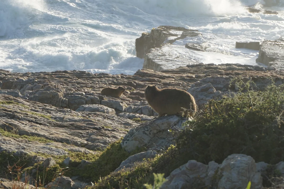
The ecological significance of the Tsitsikamma region cannot be overstated. As part of the Cape Floral Kingdom, the trail passes through vast swathes of coastal fynbos, a unique vegetation type characterised by proteas, ericas, and restios. The air is thick with the scent of wild herbs and the salty tang of the ocean. Wildlife encounters are frequent; hikers often spot Knysna turacos (Loeries) with their vibrant crimson wings, Cape clawless otters in the early morning light, and various antelope species like the bushbuck. The marine protected area extending five kilometres out to sea ensures that the coastal waters remain teeming with life, making every rocky outcrop a potential vantage point for observing the rich maritime heritage of the Garden Route.
The Otter Trail is a self-sufficient adventure. Hikers must carry everything they need for the five-day duration, including food, cooking equipment, and sleeping gear. The four overnight camps consist of two rustic wooden huts each, providing basic shelter and a communal braai (barbecue) area where the day's stories are shared under a canopy of southern stars. This lack of commercialisation is what preserves the Otter's magic; it is a place where the modern world recedes, replaced by the primal rhythms of the tides and the sun.
The history of the Otter Trail is deeply intertwined with the conservation movement in South Africa. Established in 1968, it is the oldest official hiking trail in the country. The creation of the Tsitsikamma National Park in 1964—the first marine national park in Africa—laid the groundwork for a trail that would allow people to experience the coastline without damaging its fragile ecosystems. The name "Tsitsikamma" is derived from the Khoekhoe language, meaning "place of much water," a fitting tribute to the numerous rivers and high rainfall that define the region.
Long before the arrival of European settlers and the formalisation of the trail, the coastline was inhabited by the Middle Stone Age people and later the Khoisan. Archaeological sites, including sea caves and middens (ancient refuse heaps of shells and bones), are scattered along the route, particularly near the Lottering and Elandsbos rivers. These sites provide a window into a time when humans lived in total harmony with the coastal bounty, harvesting shellfish and hunting in the dense forests. The Guano Cave on Day 1 is a notable landmark that hints at the historical exploitation of natural resources before the area was protected.
In the modern era, the Otter Trail has become a symbol of South African outdoor culture. It was designed by forestry pioneers who recognised the need for a sustainable way to showcase the Garden Route's beauty. Over the decades, the trail has maintained its "bucket list" status, with the booking system becoming legendary for its difficulty to navigate due to extreme demand. The trail's management by SANParks remains a gold standard for conservation-led tourism, ensuring that the footprint of the 4,380 hikers who complete the trail annually is kept to an absolute minimum.
Want more background? Read extended notes on history and cultural context → Learn more
The Otter Trail is a year-round destination, but the experience varies significantly between the seasons. The Garden Route has a temperate maritime climate, meaning rain can fall at any time of year, often arriving in sudden, dramatic coastal squalls. However, certain months offer more stable conditions for hiking and river crossings.
Autumn (March to May): This is widely considered the "golden window" for the Otter Trail. The scorching heat of summer begins to fade, replaced by mild, clear days and cool evenings. The sea temperature remains relatively warm, which is a significant advantage for the river crossings on Day 3 and Day 4. Wind speeds are generally lower during this period, making the cliff-top sections more manageable.
Spring (September to November): Spring brings a spectacular explosion of colour as the fynbos comes into bloom. The proteas and ericas are at their peak, attracting a variety of sunbirds and sugarbirds. While the weather can be more unpredictable with occasional spring storms, the freshness of the air and the vibrant flora make it a favourite for photographers. Whale watching is also at its best during these months, as Southern Right whales frequent the bays to calve.
Summer (December to February): Summer is hot and humid. Temperatures can frequently exceed 30 degrees Celsius, making the steep climbs particularly taxing. Hikers must be diligent about hydration and sun protection. The advantage of summer is the long daylight hours and the refreshing nature of the many swimming holes along the route. However, this is also the peak season for South African holidays, and bookings are even more competitive.
Winter (June to August): Winter offers crisp, clear days with excellent visibility, but the nights can be surprisingly cold, with temperatures dropping towards 5 degrees Celsius. The biggest challenge in winter is the sea state; large swells and high tides can make river crossings, especially the Bloukrans, significantly more dangerous. Hikers must be prepared with high-quality waterproof gear and warm layers for the evenings in the unheated huts.
Day 1: Storms River Mouth to Ngubu Hut
Day 2: Ngubu Hut to Scott Hut
Day 3: Scott Hut to Oakhurst Hut
Day 4: Oakhurst Hut to Andre Hut
Day 5: Andre Hut to Nature's Valley
Important Notes:
The Otter Trail requires significant forward planning, primarily due to its immense popularity. Bookings typically open 11 months in advance on the first working day of the month, and spots for peak periods often sell out within minutes. It is highly recommended to have a group of 6 or 12 people to book out an entire hut, though individual spots can sometimes be found through cancellations.
Physical preparation is non-negotiable. While the distances are short, the cumulative elevation gain and technical terrain are taxing. Hikers should engage in hill training and stair climbing with a weighted pack in the months leading up to the trip. Logistics involve flying into George Airport (GRJ) or Port Elizabeth (PLZ), followed by a rental car drive to Storms River Mouth. Most hikers leave a vehicle at Nature's Valley (the finish) and use a pre-arranged shuttle service to get to the start at Storms River.
Accommodation on the Otter Trail consists of four overnight camps: Ngubu, Scott, Oakhurst, and Andre. Each camp has two wooden huts, with each hut containing six bunk beds (three tiers of two). The maximum capacity per camp is 12 people.
Hut Facilities:
What Huts Don't Provide:
Booking Requirements:
The permit for the Otter Trail is essentially your booking confirmation from SANParks. Because the trail is limited to 12 people per day, your "permit" is your reserved spot in the huts. There is no option for day permits or "walking through" without a multi-day booking.
Booking Strategy:
Costs and Fees:
Check-in Process: You must present your booking confirmation and ID/Passport at the Storms River Mouth reception. You will be required to sign an indemnity form and will receive a briefing on trail conditions and the current tide table. Failure to check in by the designated time may result in your spot being cancelled.


Precisely traced GPX for the Otter Trail, ready for your GPS or favourite mapping app.
The Garden Route is an adventure playground. Consider these activities before or after your hike:
River Crossings: The single greatest hazard on the Otter Trail is the river crossings, particularly the Bloukrans River on Day 4. This river is tidal and can be extremely dangerous during high tide or after heavy inland rains. Always time your arrival for low tide. If the water is above waist height or the current is too strong, do not attempt to cross. Use the emergency escape route (clearly marked) which leads to the forest road above.
Slippery Rocks: Much of the trail involves traversing the intertidal zone. The rocks are often covered in "sea slime" or algae, making them incredibly slippery. Move slowly, use trekking poles for balance, and ensure your boots have high-friction soles. Head injuries from falls on rocks are the most common medical incidents on the trail.
Dehydration and Heat: In summer, the combination of high humidity and steep climbs can lead to rapid dehydration and heat exhaustion. Carry at least 2–3 litres of water and refill at every clean stream. Use rehydration salts in your water to maintain electrolyte balance.
Emergency Procedures: There is very limited mobile reception on the trail. In the event of a serious injury, send two members of the group to the nearest emergency exit (marked on the map) or to the next hut to find a ranger. Carry a whistle to signal for help from passing boats or other hikers. SANParks rangers patrol the area, but response times can be slow due to the terrain.
Wildlife: While generally shy, baboons can be a nuisance at the huts. Never leave food unattended and ensure hut doors are securely latched. Snakes, including the Puff Adder and Boomslang, are present; always watch where you step, especially in sunny patches on the path.
The Guano Cave: Located on Day 1, this massive sea cave is a geological marvel. It was historically used for the collection of bat guano (fertiliser). The scale of the cavern is humbling, and it provides a great spot for early-trip photography.
Skilderkrans: On Day 2, this high quartzite outcrop offers perhaps the best vantage point on the entire trail. On a clear day, you can see the coastline stretching back towards Storms River and forward towards Nature's Valley. It is a prime spot for spotting Great White sharks and dolphins in the clear water below.
Elandsbos Estuary: The crossing on Day 3 is more than just a hurdle; the estuary is a beautiful, tranquil lagoon surrounded by steep forested slopes. It is the perfect place to spend a few hours swimming and relaxing if the tide allows.
The Blue Pools: Scattered along the rocky sections of Day 1 and Day 2 are deep, crystal-clear rock pools that are safe for swimming at low tide. These "natural aquariums" are filled with colourful anemones, sea urchins, and small fish.
Nature's Valley Beach: The final 2-kilometre walk along the beach is a meditative conclusion to the journey. The sand is incredibly fine and white, and the sense of accomplishment as the Groot River lagoon comes into view is a highlight for every "Otter" finisher.
The Otter Trail passes through a Marine Protected Area and a National Park. The preservation of this environment depends entirely on the conduct of the hikers. The "Leave No Trace" principles are strictly enforced by SANParks wardens.
Your responsibility as a walker: