
Ollantaytambo to Cachicata Trail
The Ollantaytambo to Cachicata trail is a captivating day walk in the Sacred Valley of Peru, offering a blend of Inca history, stunning Andean scenery, and a glimpse into traditional rural life. This moderate hike connects the well-preserved Inca town of Ollantaytambo with the ancient quarry of Cachicata, a vital source of building stone for the impressive fortress and town above. The trail winds through agricultural terraces, past Inca ruins, and offers panoramic views of the surrounding valleys and snow-capped peaks. It's a journey that allows walkers to step back in time, exploring the ingenuity of the Inca civilisation and the enduring beauty of the Peruvian Andes.
- Distance: 12.0 km one-way
- Duration: 4–6 hours
- Season: April to October (dry season)
- Elevation gain: 400 m
- Difficulty: Moderate
- Closest City: Ollantaytambo
- Trailhead Access: Starts near Ollantaytambo's main plaza; follow signs to the Inca Bridge.
- Permits: Generally not required for this day hike, but always check local regulations.
Overview
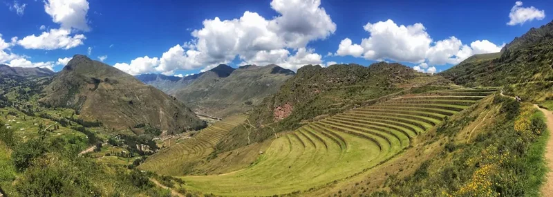
This hike is a perfect introduction to the historical and natural wonders of the Sacred Valley, manageable for most reasonably fit individuals. The trail begins in the vibrant Inca town of Ollantaytambo, a living museum where the street plan and water channels still follow their original Inca design. From here, the path ascends gradually, taking you past the iconic Inca Bridge, a testament to Inca engineering. As you climb, the views over Ollantaytambo and the surrounding agricultural terraces become increasingly spectacular. The route then leads you through a landscape dotted with smaller Inca ruins and agricultural sites, eventually reaching the vast Cachicata quarry. Here, you can witness firsthand the immense scale of the stones quarried by the Incas, many of which were transported down the mountainside to construct the formidable fortress of Ollantaytambo. The return journey can be made the same way, or for a slightly different perspective, a descent can be made via a different path, often ending closer to the town's outskirts. The trail is well-defined for the most part, though some sections can be steep and rocky, requiring careful footing. The dry season, from April to October, offers the most pleasant conditions, with sunny days and cooler temperatures, though evenings can be chilly.
The Ollantaytambo to Cachicata trail is more than just a walk; it's an immersion into the heart of the Inca Empire. You'll walk in the footsteps of those who built this incredible civilisation, marvel at their architectural prowess, and appreciate the stunning natural environment that served as their home and inspiration. The journey offers a profound connection to the past, set against a backdrop of breathtaking Andean vistas. The moderate difficulty means it's accessible without requiring extreme fitness, making it an ideal activity for travellers looking to experience the Sacred Valley beyond the main tourist hubs.
History and Cultural Context
Ollantaytambo itself is a town of immense historical significance. It was a royal estate of the Inca emperor Pachacuti, a major religious centre, and a formidable military stronghold. The town's layout, with its narrow cobblestone streets and sophisticated water channels, remains largely as it was during the Inca era. The fortress, perched on a hillside overlooking the town, is one of the most impressive surviving Inca structures, renowned for its massive stone terraces and the Temple of the Sun, which features colossal granite blocks expertly carved and fitted together.
The Cachicata quarry, the destination of this hike, played a crucial role in the construction of Ollantaytambo. Located on the opposite side of the Urubamba River valley, this vast quarry was the source of the massive pink granite blocks used for the Temple of the Sun and other key structures in the fortress. The Incas employed remarkable engineering skills to extract these stones, shape them, and then transport them down the steep mountainside to the river, and across it, to the construction site. Evidence of this monumental effort is still visible today: enormous, partially cut stones remain in the quarry, and a network of ramps, channels, and even a large stone roller (often referred to as the "Rope Roller") can be seen along the descent route. The sheer scale of the operation at Cachicata highlights the advanced logistical and engineering capabilities of the Inca civilisation.
The trail between Ollantaytambo and Cachicata is, in essence, an ancient Inca pathway. It was likely used by workers, priests, and travellers for centuries. Walking this path provides a tangible connection to this rich history, allowing you to appreciate the scale of Inca ambition and the labour involved in creating their magnificent cities and fortresses. The surrounding landscape, with its fertile valleys and imposing mountains, was also deeply significant to the Incas, who revered natural elements and incorporated them into their cosmology and architecture.
Seasonal Highlights and Weather Reality
The best time to undertake the Ollantaytambo to Cachicata hike is during the dry season, which typically runs from April to October. During these months, the weather is generally stable, with clear blue skies and abundant sunshine. This makes for pleasant hiking conditions, with daytime temperatures often ranging from 15°C to 25°C. The dry season also offers excellent visibility, allowing for stunning panoramic views of the Sacred Valley, the Urubamba River, and the surrounding snow-capped peaks, including Veronica and Sahuasiray.
However, it's important to note that even during the dry season, Andean weather can be unpredictable. Mornings can be cool, and temperatures can drop significantly after sunset. It is advisable to carry layers of clothing to adapt to changing conditions. While rain is infrequent during this period, brief showers can still occur, especially in the late afternoon.
The wet season, from November to March, is generally not recommended for this hike. Heavy rainfall can make the trails muddy, slippery, and potentially hazardous. River levels can rise, and visibility may be significantly reduced due to cloud cover and fog. While the landscape is lush and green during the wet season, the practicalities of hiking make the dry season a far more enjoyable and safer choice.
For those who do hike during the shoulder months of April, May, September, or October, you can expect fewer crowds than in the peak dry season, and the temperatures are often milder. These months offer a good balance of favourable weather and a more tranquil experience.
Recommended Itinerary

Ollantaytambo to Cachicata Day Hike Itinerary
Early Morning (Approx. 8:00 AM): Start in Ollantaytambo
- Begin your hike from Ollantaytambo town. Head towards the northern edge of town, following signs for the Inca Bridge (Puente Inca).
- The trailhead is easily accessible from the main plaza.
- Take a moment to appreciate the well-preserved Inca architecture and water channels of Ollantaytambo before you depart.
Morning (Approx. 8:30 AM - 10:30 AM): Ascent to the Inca Bridge and Terraces
- Follow the path upwards from Ollantaytambo.
- The initial part of the trail is relatively gentle, passing through agricultural fields and small rural settlements.
- Reach the Inca Bridge, an impressive ancient structure that once served as a vital crossing point.
- Continue ascending, passing by extensive Inca agricultural terraces that climb the hillsides. These terraces demonstrate the Incas' mastery of land management and agriculture in challenging terrain.
- Enjoy increasingly expansive views of Ollantaytambo town and the surrounding valley.
Midday (Approx. 10:30 AM - 1:00 PM): Reaching the Cachicata Quarry
- The trail becomes steeper and more rugged as you approach the Cachicata quarry.
- Explore the quarry site, marvelling at the enormous granite blocks, some still partially attached to the bedrock, others seemingly abandoned mid-transport.
- Observe the evidence of Inca quarrying techniques, including hammer stones and carved channels.
- Locate the "Rope Roller," a large stone believed to have been used to help manoeuvre the massive blocks.
- Take time to absorb the scale of this ancient industrial site and imagine the immense human effort involved.
- Find a suitable spot for a picnic lunch amidst the ruins, enjoying the panoramic views.
Afternoon (Approx. 1:00 PM - 3:00 PM): Descent and Return to Ollantaytambo
- Begin your descent back towards Ollantaytambo. You can retrace your steps or opt for a slightly different route if available and well-marked.
- The descent offers new perspectives on the valley and the impressive engineering of the terraces and pathways.
- Be mindful of your footing on the steeper sections.
- As you approach Ollantaytambo, you'll pass through more agricultural land and potentially encounter local farmers.
Late Afternoon (Approx. 3:00 PM - 4:00 PM): Arrival in Ollantaytambo
- Arrive back in Ollantaytambo, completing your 12 km hike.
- You will likely end up on the outskirts of town, a short walk back to the main plaza.
- Celebrate your accomplishment with a well-deserved meal or drink in one of Ollantaytambo's many excellent restaurants.
Important Notes:
- This is a day hike; no overnight accommodation is required.
- Carry sufficient water and snacks, as there are no facilities along the trail.
- Wear sturdy hiking boots with good ankle support.
- Sun protection (hat, sunscreen, sunglasses) is essential due to the high altitude and strong sun.
- The trail can be steep and rocky in places; take your time and be aware of your surroundings.
- Consider hiring a local guide in Ollantaytambo for deeper historical insights.
Planning and Bookings
Book Your Trip
Everything you need to plan your journey
Accommodation
Find places to stay near Ollantaytambo
Flights
Search flights to Ollantaytambo
Essential Preparation
The Ollantaytambo to Cachicata trail is a day hike, meaning no complex multi-day booking coordination is required. However, proper preparation is key to enjoying this moderate trek. The primary logistical hub is the town of Ollantaytambo itself. This historic town offers a range of accommodation options, from budget hostels to comfortable hotels, catering to various traveller needs. It also boasts numerous restaurants, cafes, and shops where you can purchase supplies, hire guides, or simply relax and soak in the atmosphere. Getting to Ollantaytambo is straightforward; the nearest major airport is in Cusco (CUZ). From Cusco, you can take a colectivo (shared minivan) or a private taxi to Ollantaytambo, a journey of approximately 1.5 to 2 hours. The trailhead for the Cachicata hike is easily accessible from Ollantaytambo's main plaza, typically marked with signs pointing towards the Inca Bridge.
Trail Accommodation
This is a day hike requiring no overnight accommodation.
Required Gear
- Sturdy hiking boots: Essential for navigating the uneven, rocky, and sometimes steep terrain. Ensure they are well broken-in to prevent blisters.
- Waterproof and windproof jacket: Andean weather can change rapidly. A jacket that can protect you from rain and wind is crucial, even during the dry season.
- Warm layers: Include a fleece or insulated jacket, and a hat and gloves. Temperatures can drop significantly, especially at higher elevations or in the early morning and late afternoon.
- Sun protection: High-altitude sun is intense. A wide-brimmed hat, sunglasses with UV protection, and high SPF sunscreen are non-negotiable.
- Backpack: A comfortable daypack (20-30 litres) to carry water, snacks, extra clothing, and personal items.
- Navigation: While the trail is generally well-defined, a map of the area or a GPS device/app on your phone can be helpful, especially if you plan to explore slightly off the main path.
- First-aid kit: Include essentials like plasters, antiseptic wipes, pain relievers, and any personal medications.
What to Bring
- Water: Carry at least 2-3 litres of water per person. There are no reliable water sources or purification facilities along the trail.
- Food: Pack plenty of high-energy snacks such as trail mix, energy bars, fruit, and sandwiches.
- Camera: To capture the stunning scenery and historical sites.
- Insect repellent: While not as prevalent as in the Amazon, some biting insects can be present, especially near water sources or in the late afternoon.
- Cash: Small denominations of Peruvian Soles (PEN) are useful for purchasing snacks or drinks in Ollantaytambo before or after your hike, or for hiring a guide.
- Trekking poles (optional): Can be beneficial for stability on steep ascents and descents, particularly for those with knee issues.
- Hand sanitiser: For hygiene, especially before eating.
Permits
For the Ollantaytambo to Cachicata trail, typically no specific permits are required for independent hikers. This is a popular day hike that is generally accessible without formal booking procedures or entrance fees, unlike some of the more regulated Inca Trail routes. However, it is always advisable to check with local authorities or your accommodation provider in Ollantaytambo for any last-minute changes in regulations or local requirements, especially if you plan to visit specific protected areas or ruins that might have their own access rules.
If you choose to hire a local guide in Ollantaytambo, they will be aware of any necessary permissions or fees. Guides can also offer valuable insights into the history and significance of the sites you will encounter, enhancing your overall experience. The primary "cost" associated with this hike is your own preparation: ensuring you have adequate water, food, and appropriate gear for a moderate day trek at altitude.
Other Activities in the Area
Ollantaytambo and the surrounding Sacred Valley offer a wealth of activities to complement your hike:
- Explore Ollantaytambo Fortress: Dedicate ample time to exploring the magnificent Inca fortress and town. Climb the terraces, visit the Temple of the Sun, and wander through the ancient streets.
- Visit the Ollantaytambo Museum: Located within the town, this museum provides further context on the history and archaeology of the region.
- Maras Salt Mines: A fascinating network of thousands of salt pans used since Inca times. A short taxi or colectivo ride from Ollantaytambo.
- Moray Agricultural Terraces: Unique circular terraces believed to have been an Inca agricultural laboratory. Located near Maras.
- Pisac Market and Ruins: Famous for its vibrant Sunday market (though smaller markets operate on other days) and impressive Inca ruins overlooking the town.
- Urubamba River Rafting: For the adventurous, sections of the Urubamba River offer opportunities for white-water rafting.
- Sacred Valley Tour: Many tour operators offer day tours that combine several of these attractions, providing convenient transport and guided commentary.
- Cusco Exploration: Spend time in the historic city of Cusco, the former capital of the Inca Empire, with its colonial architecture, Inca walls, and numerous museums and attractions.
Safety and Conditions
Altitude Sickness: Ollantaytambo is situated at approximately 2,792 metres (2,791 m) above sea level. The Cachicata trail ascends further, reaching an elevation of around 3,000 metres (2,999 m) or more. Altitude sickness (soroche) can affect anyone, regardless of fitness level. Symptoms include headache, nausea, dizziness, and fatigue. To mitigate the risk:
- Spend a day or two acclimatising in Cusco (3,400 m) or Ollantaytambo before undertaking strenuous activity.
- Stay hydrated by drinking plenty of water.
- Avoid alcohol and heavy meals on your first day at altitude.
- Consider consulting your doctor about altitude medication (e.g., Diamox).
- If symptoms worsen, descend to a lower altitude immediately.
Trail Conditions: The trail is generally well-trodden but can be uneven, rocky, and steep in sections, particularly as you approach the quarry. Loose gravel can be present, so sturdy footwear is essential. During the wet season (November to March), the path can become muddy and slippery, increasing the risk of falls. Always watch your footing.
Weather: Andean weather is notoriously changeable. Even during the dry season, temperatures can fluctuate significantly between day and night, and sudden cloud cover can bring a chill. Be prepared for strong sun exposure during the day. Always check the weather forecast before you set out.
Navigation: While the main trail to Cachicata is relatively straightforward, it's wise to have a map or GPS device, especially if you plan to explore any side paths or alternative descent routes. Hiring a local guide is the best way to ensure you stay on track and gain historical context.
Water and Food: There are no facilities along the trail. Carry all the water and food you will need for the entire hike. Dehydration can exacerbate altitude sickness symptoms.
Emergency Contacts: In case of an emergency, your mobile phone may have limited signal. It's advisable to inform someone of your hiking plans and expected return time. Emergency services can be contacted via local numbers, but response times may vary.
Side Trips and Points of Interest
Inca Bridge (Puente Inca): Located early in the hike, this is a fascinating example of Inca engineering. While the original structure may have been modified over time, it represents a crucial crossing point used by the Incas to access the quarry and other areas. It's a good spot to pause and appreciate the ingenuity required to build infrastructure in such challenging terrain.
Agricultural Terraces: As you ascend from Ollantaytambo, you will pass numerous extensive agricultural terraces. These are not just visually striking but also demonstrate the Incas' advanced understanding of soil management, irrigation, and microclimate creation to maximise food production in the steep Andean landscape.
Cachicata Quarry: The main destination of the hike. This vast site is littered with enormous, partially worked granite blocks, some weighing many tonnes. You can see the marks left by Inca tools and observe the scale of the operation. It's a powerful testament to the labour and organisation of the Inca Empire.
The "Rope Roller" (or similar large stones): Along the descent route from Cachicata, you may encounter large, shaped stones that are believed to have been used as rollers or counterweights to help move the massive blocks down the mountain. Their presence offers tangible evidence of the methods employed by the Incas.
Panoramic Viewpoints: The entire trail offers spectacular viewpoints. As you gain elevation, the vistas over Ollantaytambo, the Urubamba River valley, and the surrounding snow-capped peaks become increasingly breathtaking. These viewpoints are ideal for photography and for appreciating the grandeur of the Sacred Valley.
Leave No Trace
The Ollantaytambo to Cachicata trail traverses a landscape rich in history and natural beauty. Practising Leave No Trace principles ensures that this area remains pristine for future generations and respects the cultural significance of the Inca sites.
- Pack it in, Pack it out: Carry out all litter, including food scraps, wrappers, and any other waste you generate. Do not leave anything behind.
- Stay on the Trail: Stick to the marked paths to avoid damaging fragile vegetation and to prevent erosion, especially on the steep terraces and quarry slopes.
- Respect Cultural Heritage: The Inca ruins and quarry sites are ancient and historically significant. Do not climb on or disturb the stonework, remove artefacts, or deface any structures. Treat these sites with the reverence they deserve.
- Dispose of Waste Properly: Use designated toilet facilities in Ollantaytambo before and after your hike. If nature calls on the trail, dig a cathole at least 60 metres (60 m) away from water sources, trails, and campsites, and bury your waste. Pack out all toilet paper.
- Leave What You Find: Do not take any rocks, plants, or other natural objects from the site.
- Be Considerate of Others: Keep noise levels down to allow everyone to enjoy the natural environment and the historical atmosphere.
- Travel and Camp on Durable Surfaces: For this day hike, this means staying on the established trail.
By adhering to these principles, you help preserve the integrity of this remarkable historical and natural landscape.