O Circuit Torres del Paine - The Ultimate Patagonian Wilderness
The O Circuit in Torres del Paine National Park is widely regarded as one of the most spectacular multi-day treks on the planet. Located in the deep south of Chilean Patagonia, this 130-kilometre loop encompasses the entirety of the famous "W" Trek but extends deep into the remote northern reaches of the park, offering a 360-degree circumnavigation of the Cordillera del Paine. While the W Trek provides a glimpse of the park's most famous landmarks, the O Circuit delivers a profound immersion into a landscape of glaciated mountain passes, ancient sub-antarctic forests, and the staggering expanse of the Southern Patagonian Ice Field. It is a journey that demands physical resilience, meticulous planning, and a deep respect for the volatile weather systems of the Southern Hemisphere.
Spanning between seven and ten days, the route traverses a diverse array of ecosystems. Walkers begin in the golden pampas of the eastern park boundary, climb through dense Lenga and Coihue forests, navigate the high-altitude challenge of the John Gardner Pass, and descend alongside the massive calving face of Glacier Grey. The "O" is a one-directional loop (counter-clockwise) designed to manage trail traffic and protect the fragile environment. This regulation ensures that the northern section of the trail remains a sanctuary of relative solitude, where the sound of cracking glacial ice and the wind through the southern beech trees are the primary soundtracks to your journey. For those seeking the definitive Patagonian experience, the O Circuit is the gold standard.
- Distance: 130.0 km loop
- Duration: 7–10 days
- Season: November to March (bookings mandatory; trail closed in winter)
- Accommodation: Campsites and Refugios (mandatory pre-booking across three different providers)
- Highest point: John Gardner Pass (1,241 m)
- Difficulty: Challenging (requires high fitness and multi-day trekking experience)
- Direction: Counter-clockwise only (strictly enforced by park rangers)
Overview
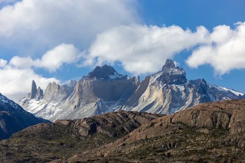
The O Circuit is a masterclass in geological drama. The Cordillera del Paine is a small but incredibly vertical mountain group, a tectonic uplift of granite and sedimentary rock that has been sculpted by successive ice ages into the jagged spires and deep valleys seen today. The circuit allows walkers to see every facet of this massif. The first half of the trek (the "back side") is the most remote, taking hikers away from the day-tripping crowds and into the quiet valleys of the Rio Paine. Here, the scale of the landscape becomes apparent as you walk toward the massive Southern Patagonian Ice Field—the world's second-largest contiguous extrapolar ice field.
The emotional and physical crux of the journey is the ascent of the John Gardner Pass. Standing at 1,241 metres, the pass offers a view that many hikers describe as life-changing: a seemingly infinite sea of ice stretching toward the horizon, where Glacier Grey spills from the ice field into the lake of the same name. The descent from the pass is a steep, knee-jarring transition from alpine rock and snow into lush, moss-draped rainforest. Once the route joins the "W" section at Refugio Grey, the trail becomes more social and the infrastructure more developed, but the scenery remains world-class as you enter the French Valley and finally reach the base of the iconic Las Torres (The Towers).
Patagonia is defined by its weather. The region sits in the path of the "Roaring Forties" and "Furious Fifties" winds, which can reach speeds of over 100 kilometres per hour, often carrying rain, sleet, or snow even in the height of summer. Walking the O Circuit is as much a mental challenge as a physical one; hikers must be prepared to navigate muddy trails, cross suspension bridges over roaring glacial rivers, and endure the relentless Patagonian wind. However, the reward is a sense of accomplishment and a connection to one of the last truly wild places on Earth. The infrastructure, while strictly regulated, provides a safe framework for this adventure, with designated campsites and refugios spaced at manageable intervals.
History and Cultural Context
The land now known as Torres del Paine National Park has a human history stretching back thousands of years. The original inhabitants were the Aonikenk people, also known as the Tehuelche. These nomadic hunter-gatherers roamed the Patagonian pampas, following the seasonal migrations of guanacos (a relative of the llama). To the Aonikenk, the mountains were a sacred and formidable presence. The name "Paine" is derived from an indigenous word meaning "blue," a reference to the striking colour of the glacial lakes and the ice itself. European contact in the late 19th century brought devastating changes to the Aonikenk through disease and conflict with sheep ranchers, and today their legacy is primarily found in archaeological sites and the names of the landmarks.
The first recorded tourist to the area was Lady Florence Dixie, a British aristocrat and travel writer who arrived in 1879. In her book "Across Patagonia," she referred to the three granite spires as "Cleopatra's Needles." Her writings sparked international interest in the region's jagged beauty. Throughout the early 20th century, the area was primarily used for large-scale sheep farming (estancias), which led to significant deforestation as land was cleared for grazing. Recognising the unique ecological value of the landscape, the Chilean government established the Parque Nacional de Turismo Lago Grey in 1959, which was later renamed Torres del Paine National Park in 1970.
In 1978, the park was designated a UNESCO Biosphere Reserve, acknowledging its status as a global priority for conservation. The development of the O Circuit as a formal trekking route occurred much later than the W Trek, as the northern section required the construction of bridges and more robust trail management. Today, the park is managed by CONAF (Corporación Nacional Forestal), which works alongside private concessionaires to balance the high volume of international tourism with the need to protect the park's biodiversity, including the endangered South Andean Huemul (deer) and the resident puma population. The history of the park is also marked by tragedy; major forest fires in 1985, 2005, and 2011—all caused by human negligence—destroyed tens of thousands of hectares of native forest, leading to the strict "no fire" policies currently in place.
Want more background? Read extended notes on history and cultural context → Learn more
Seasonal Highlights and Weather Reality
The O Circuit is only open to the public during the southern spring, summer, and early autumn (typically from 1 November to 31 March). Outside of this window, the northern section of the trail, particularly the John Gardner Pass, is covered in deep snow and becomes impassable for anyone without advanced mountaineering skills and specific winter permits. Even during the open season, the weather is the most significant factor in any trekker's experience.
Summer (December to February): This is the peak season. Days are incredibly long, with up to 18 hours of daylight, allowing for a relaxed pace. Temperatures are at their warmest, ranging from 5°C at night to 20°C during the day. However, this is also the windiest time of year. The famous Patagonian winds are most consistent in summer, capable of knocking hikers off their feet and making the crossing of the John Gardner Pass a serious undertaking. Campsites are at full capacity, and the social atmosphere is vibrant.
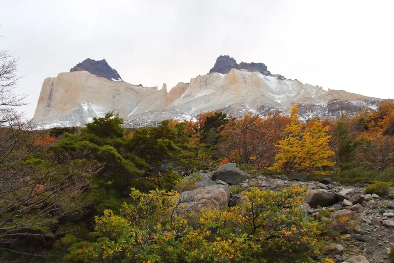
Shoulder Seasons (November and March): These months offer a quieter experience and are preferred by many experienced hikers. In November, the spring wildflowers are in bloom, and the mountains still hold a significant amount of snow, making for dramatic photography. March brings the spectacular autumn colours, as the Lenga forests turn vibrant shades of red and orange. The wind is generally less intense than in mid-summer, but the nights are colder, often dropping below freezing. Snow can fall at any time of year on the pass, but it is more likely in the shoulder seasons.
Weather Reality: Regardless of the month, hikers must prepare for "four seasons in one day." It is common to start a morning in bright sunshine, experience a torrential rainstorm by midday, and face sleet or snow by evening. The wind chill factor is significant; a 10°C day can feel like 0°C when the wind is blowing off the ice field. Waterproofing is not optional—it is a survival requirement. The park rangers at Campamento Los Perros will often hold hikers back and prevent them from attempting the John Gardner Pass if the wind speeds or visibility are deemed too dangerous.
Recommended Itinerary
8-Day O Circuit Itinerary
Day 1: Central to Serón
- Distance: 13.5 km
- Elevation gain: 250 m
- Time: 4–5 hours
- Start at Laguna Amarga entrance or Refugio Las Torres
- Easy walking through open pampas and light forest
- Views of the Rio Paine and the back side of the Almirante Nieto mountain
- Look for guanacos and caracaras along the trail
- Arrive at Camping Serón, a grassy meadow site
- A gentle introduction to the trail, allowing for gear adjustments
Day 2: Serón to Dickson
- Distance: 18.5 km
- Elevation gain: 400 m
- Time: 6–7 hours
- Follow the Rio Paine through marshlands and over a small pass
- Pass through the "Dead Forest" and climb a ridge for views of Lago Dickson
- The trail can be very muddy in the marshy sections
- Arrive at Refugio/Camping Dickson, located on a stunning peninsula
- Dickson is often cited as the most beautiful campsite on the circuit, with views of the Dickson Glacier
Day 3: Dickson to Los Perros
- Distance: 12 km
- Elevation gain: 350 m
- Time: 4.5–5 hours
- Walk through ancient, mossy Lenga forests alongside the Rio de los Perros
- Gradual but steady climb toward the base of the pass
- Pass the spectacular Perros Glacier and its terminal lake
- Arrive at Camping Los Perros (no refugio here, camping only)
- This is the coldest campsite on the trek; prepare for a chilly night
- Mandatory ranger check-in for the pass crossing the following morning
Day 4: Los Perros to Paso (The John Gardner Pass)
- Distance: 12 km
- Elevation: 600 m gain, 800 m descent
- Time: 7–9 hours
- The most challenging day of the circuit
- Steep climb through mud and then over rocky scree or snow to the pass (1,241 m)
- Incredible views of the Southern Patagonian Ice Field from the summit
- Extremely steep and technical descent through forest to the Grey Glacier viewpoint
- Arrive at Camping Paso, a basic site carved into the forest
- Many hikers continue to Refugio Grey, but stopping at Paso allows for a more relaxed pace
Day 5: Paso to Grey
- Distance: 7 km
- Elevation: 200 m gain, 400 m descent
- Time: 3–4 hours
- Walk along the ridge overlooking Glacier Grey
- Cross three massive suspension bridges over deep canyons
- Spectacular views of icebergs floating in Lago Grey
- Arrive at Refugio/Camping Grey
- Afternoon options: Kayaking near the glacier or a boat trip to the glacier face
Day 6: Grey to Paine Grande
- Distance: 11 km
- Elevation: 200 m gain, 200 m descent
- Time: 3.5–4.5 hours
- Relatively easy walk through the "Quebrada de los Vientos" (Windy Gully)
- Views of the Olguin Range and the blue waters of Lago Pehoé
- Pass through areas recovering from the 2011 fire
- Arrive at Refugio/Camping Paine Grande, the largest hub in the park
- Facilities here include a bar, mini-market, and large dining hall
Day 7: Paine Grande to Frances/Cuernos via Valle del Francés
- Distance: 20 km (including the valley)
- Elevation: 600 m gain, 600 m descent
- Time: 8–10 hours
- Drop heavy packs at Campamento Italiano
- Climb into the French Valley to the "Mirador Francés" and "Mirador Británico"
- Surrounded by a 360-degree amphitheatre of granite peaks and hanging glaciers
- Listen for the thunder of avalanches on Cerro Paine Grande
- Retrieve packs and continue to Camping Frances or Refugio Cuernos
Day 8: Cuernos to Central via The Towers
- Distance: 22 km
- Elevation: 800 m gain, 800 m descent
- Time: 9–11 hours
- Walk along the shores of Lago Nordenskjöld
- Climb the steep "Ascencio Valley" to the base of the towers
- Final rocky scramble to the Mirador Base Las Torres
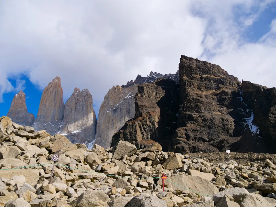
- View the three iconic granite spires and the glacial lake below
- Descend to Refugio Las Torres/Central to finish the loop
- Catch the shuttle bus back to Laguna Amarga and the bus to Puerto Natales
Important Notes:
- The itinerary can be extended to 9 or 10 days by staying extra nights at Dickson or Grey.
- The direction is strictly counter-clockwise; you cannot walk the O Circuit in reverse.
- Reservations are checked by rangers at multiple points; you cannot enter the "O" section without proof of all bookings.
- Water is plentiful and generally safe to drink from streams, but a filter is recommended for peace of mind.
- The John Gardner Pass may be closed in high winds; always have a "buffer day" in your travel plans.
Planning and Bookings
Book Your Trip
Everything you need to plan your journey
Accommodation
Find places to stay near Puerto Natales
Flights
Search flights to Puerto Natales
Essential Preparation
Planning the O Circuit is a logistical puzzle that must be solved months in advance. Because the trail is managed by three different entities—CONAF (the national forest service), Vertice Patagonia, and Las Torres Patagonia (formerly Fantastico Sur)—you must coordinate bookings across three separate websites. It is highly recommended to start planning at least six months before your intended start date, as the limited camping spots on the northern section sell out almost instantly when bookings open (usually in June or July).
Physical preparation is equally vital. You will be carrying a pack weighing between 12 and 18 kilograms (if camping and carrying food) over rugged, uneven terrain for 7 to 10 consecutive days. Training should include long-distance walks with a weighted pack and elevation gain. Puerto Natales is the gateway city where you will do your final preparation. It is a three-hour bus ride from Punta Arenas. In Puerto Natales, you can rent gear, buy fuel canisters (which cannot be taken on planes), and attend the daily "3 O'Clock Talk" at Erratic Rock hostel, which provides invaluable real-time trail information.
Trail Accommodation
Accommodation on the O Circuit consists of a mix of Refugios (mountain hostels) and designated campsites. You are not permitted to wild camp anywhere in the park. Most sites offer the option to rent a pre-pitched tent, sleeping bag, and mat, which significantly reduces pack weight but increases cost.
Hut and Campsite Facilities:
- Refugios (Grey, Paine Grande, Dickson, Cuernos, Central): Offer bunk beds in shared dorms, hot showers, flush toilets, and a restaurant serving set meals.
- Campsites: All sites have basic bathroom facilities (toilets and sinks). Most have showers, though hot water is often limited to specific hours.
- Cooking Areas: Every campsite has a designated "quincho" or sheltered cooking area. Cooking is strictly prohibited outside these areas due to fire risk.
- Electricity: Available in the main refugios for limited hours, but often absent or very limited at Serón, Perros, and Paso. Bring a power bank.
- Supplies: Small kiosks at most sites sell basic snacks, pasta, and expensive beer/soda. Do not rely on them for full meals.
What is NOT Provided:
- Towels and toiletries (even in refugios).
- Cooking equipment (pots, pans, stoves, fuel) for campers.
- WiFi (available for a high fee at some refugios, but very unreliable).
- Trash disposal on the "back side" (you must carry all your rubbish from Serón to Grey).
Booking Requirements:
- Vertice Patagonia: Manages Dickson, Perros, Grey, and Paine Grande.
- Las Torres Patagonia: Manages Serón, Frances, Cuernos, and Central.
- CONAF: Manages Paso and Italiano (these are free but must be booked on the CONAF website and are often the hardest to secure).
- Costs vary wildly: Camping is roughly US$20–30 per night, while a bed in a refugio with meals can exceed US$150–200 per night.
Required Gear
- Hiking Boots: High-cut, waterproof, and thoroughly broken in. The trail is rocky, muddy, and involves significant ankle-straining terrain.
- Waterproof Shell: A high-quality Gore-Tex jacket with a hood. It must be able to withstand hours of driving rain and high winds.
- Waterproof Overtrousers: Essential for the pass and rainy days.
- Backpack: 50–70L for campers, 35–45L for those staying in refugios. Must have a high-quality rain cover.
- Sleeping Bag: Rated to at least -5°C comfort level. Even in summer, temperatures at Los Perros and Paso can drop below freezing.
- Tent: If not renting, you need a sturdy 3-season or 4-season tent capable of withstanding 100km/h winds. Lightweight "ultralight" tents often fail in Patagonia.
- Trekking Poles: Highly recommended for the steep descent from John Gardner Pass and for stability in high winds.
- Head Torch: With spare batteries.
What to Bring
- Layered Clothing: Merino wool base layers (top and bottom), a fleece or down mid-layer, and quick-dry hiking trousers. Avoid cotton at all costs.
- Food: Lightweight, high-calorie meals (dehydrated meals, pasta, nuts, chocolate, oatmeal). You can buy meals at refugios if pre-booked, but it is expensive.
- Stove and Fuel: Screw-top isobutane canisters are the standard in Chile. Buy these in Puerto Natales.
- Water Treatment: While many drink straight from the streams, a Sawyer Squeeze or Katadyn BeFree provides safety against upstream contamination.
- Sun Protection: SPF 50+ sunscreen, lip balm with SPF, and sunglasses. The ozone layer is thin here; you will burn even on cloudy days.
- First Aid: Extensive blister kit (Compeed), ibuprofen, antiseptic cream, and any personal medications.
- Dry Bags: Use them for everything inside your pack. A pack cover is rarely enough in Patagonian rain.
- Cash: Chilean Pesos for small purchases at kiosks and for the shuttle bus/catamaran.
Permits
There is no single "permit" for the O Circuit; instead, your permits are your confirmed accommodation bookings. Park rangers at the Laguna Amarga entrance and at the entrance to the O-section (near Serón) will demand to see your printed or digital reservations for every single night of your trek. If you are missing even one night, you will be denied entry to the circuit.
Booking Strategy:
- Determine your start date and work forward. The "bottleneck" sites are Los Perros and Dickson. Secure those first.
- Bookings usually open in June or July for the following season (November–March). Follow the social media accounts of Vertice and Las Torres for announcement dates.
- Have all three booking websites open simultaneously. The systems are notoriously glitchy and often crash on opening day.
- If you cannot find availability, check back daily. Cancellations do happen, especially 30–60 days before the date when final payments are often due.
- Ensure the names on your bookings match your passport exactly.
Park Entrance Fees:
- In addition to accommodation, you must purchase a park entrance ticket via the "Pase Parque" website (aspticket.cl).
- For international visitors, the fee for a stay of more than 3 days is approximately US$49 (subject to change).
- You must download the QR code for your ticket to your phone, as there is no signal at the park gates.
Logistics and Transport:
- Bus to Park: Buses depart Puerto Natales at 7:00 AM and 2:30 PM. The journey takes 2.5 to 3 hours.
- Laguna Amarga: This is the main drop-off point. From here, you take a small shuttle bus (paid in cash) to the Las Torres area to start the O Circuit.
- Pudeto/Catamaran: If you finish at Paine Grande, you take the "Hielos Patagonicos" catamaran across Lago Pehoé to Pudeto to catch the bus back to town.
Other Activities in the Area
If you have extra time in Torres del Paine or Puerto Natales, consider these experiences:
- Glacier Grey Ice Hike: From Refugio Grey, you can join a guided excursion to walk on the ice of the glacier itself. This requires crampons and ice axes (provided) and offers a unique perspective on the glacial crevasses.
- Kayaking Lago Grey: Paddle among the massive blue icebergs that have broken off the glacier. It is a serene and humbling way to experience the scale of the ice.
- Puma Tracking: The eastern side of the park has one of the highest densities of pumas in the world. Specialist guides offer tracking tours (usually very expensive) to see these elusive cats in their natural habitat.
- Balmaceda and Serrano Glacier Boat Tour: A full-day boat trip from Puerto Natales through the Ultima Esperanza Fjord to see glaciers that are inaccessible by foot.
- Milodon Cave: Located just outside Puerto Natales, this massive cave is where the remains of a prehistoric giant ground sloth were discovered in the 1890s.
- Fly Fishing: The rivers around the park are world-renowned for trout and salmon fishing.
Safety and Conditions
The John Gardner Pass: This is the most dangerous section of the trail. The weather at the pass can be radically different from the weather at Campamento Los Perros. If the wind is gusting above 80km/h, do not attempt the crossing. Rangers at Los Perros usually provide a morning briefing; listen to their advice. If you are caught in a whiteout, stay on the trail markers (orange-topped poles). Hypothermia is a genuine risk if you get wet and the wind picks up.
River Crossings and Bridges: While most major rivers have sturdy suspension bridges, smaller streams can swell rapidly during heavy rain. Use trekking poles for stability. The suspension bridges near Glacier Grey are very high and can be intimidating in high winds; cross one person at a time.
Wildlife: Pumas are present throughout the park. While they generally avoid humans, if you encounter one: do not run, make yourself look large, shout, and maintain eye contact. Guanacos are harmless but can spit if provoked. Do not leave food in your tent, as mice and foxes are common and will chew through expensive gear to reach a snack.
Health: Blisters and knee strain are the most common injuries. Address "hot spots" on your feet immediately. The descent from the pass is particularly hard on the joints; use your poles to take the weight off your knees. There is no cell service on most of the O Circuit; in an emergency, you must reach the nearest Refugio or Ranger Station. Carrying a satellite messenger (like a Garmin inReach) is highly recommended.
Side Trips and Points of Interest
Mirador Británico: Located at the very end of the French Valley, this viewpoint is often skipped by tired hikers, but it is arguably the best view in the park. You are surrounded by the granite walls of the Paine Grande, the Cuernos, and the Shark's Fin. The 360-degree panorama of rock and ice is staggering.
The Suspension Bridges: Between Campamento Paso and Refugio Grey, there are three major suspension bridges. The second and third bridges offer incredible views directly down into the crevasses of the glacier's edge. They are engineering marvels in such a remote location.
Lago Dickson: Take the time to walk down to the beach at Camping Dickson. The water is filled with glacial flour, giving it a milky turquoise colour, and you can often see small icebergs that have drifted from the Dickson Glacier at the far end of the lake.
Mirador Base Las Torres: The classic "postcard" view. Most O-Circuiters visit this on their final day. For the best experience, many try to reach the towers for sunrise, when the granite glows a brilliant orange. This requires a very early start (usually 3:00 or 4:00 AM) from Camping Central or Chileno.
Leave No Trace
Torres del Paine is a fragile ecosystem under immense pressure from tourism. The "Leave No Trace" principles are not just suggestions here; they are strictly enforced by law. Chile has a zero-tolerance policy for fire in the park; lighting a fire outside of designated areas can result in immediate expulsion from the country and heavy fines or imprisonment.
Your responsibility as a walker:
- Fire: Never use a stove outside of the designated cooking shelters. Never smoke on the trail. The 2011 fire, which destroyed 17,000 hectares, was started by a single hiker burning toilet paper.
- Waste: Pack out everything. On the northern section (Serón to Grey), there are no trash cans. You must carry your rubbish with you. This includes organic waste like banana peels or apple cores, which do not decompose quickly in this climate and can harm local wildlife.
- Human Waste: Use the toilets at the campsites. If you are caught between sites, dig a "cathole" at least 20 centimetres deep and 60 metres from any water source. Pack out your toilet paper in a sealed plastic bag.
- Stay on the Trail: The soil in Patagonia is thin and easily eroded. Walking off-trail destroys the delicate mosses and lichens that hold the soil together.
- Water: Do not use soap (even biodegradable soap) directly in the streams. Carry water 60 metres away from the source for washing.
Useful Links
- Vertice Patagonia (Bookings for Dickson, Perros, Grey, Paine Grande)
- Las Torres Patagonia (Bookings for Serón, Cuernos, Frances, Central)
- CONAF - Park Entrance Tickets and Paso/Italiano Bookings
- MeteoChile - Official Weather Forecasts
- Buses Pacheco (Transport from Punta Arenas to Puerto Natales)
- Buses Fernandez (Transport from Punta Arenas to Puerto Natales)