North Drakensberg Traverse - The Roof of South Africa
The North Drakensberg Traverse is widely regarded as the premier high-altitude wilderness trek in Southern Africa. Spanning approximately 65 kilometres along the rugged basalt escarpment that forms the border between South Africa and the mountain kingdom of Lesotho, this journey is not a "trail" in the traditional sense. There are no waymarkers, no manicured paths, and no permanent huts. Instead, hikers navigate a vast, prehistoric landscape of sheer cliffs, rolling alpine grasslands, and dramatic "khulus" (peaks over 3,000 metres). The route begins at the iconic Sentinel Car Park, ascends the famous chain ladders to the top of the Amphitheatre—one of the most impressive cliff faces on Earth—and concludes with a descent through the jagged spires of the Cathedral Peak range. This is a journey through the uKhahlamba-Drakensberg Park, a UNESCO World Heritage site recognised for both its exceptional natural beauty and its wealth of ancient San rock art.
- Distance: 65.0 km (variable depending on navigation)
- Duration: 4–6 days
- Season: April–May and September–October (avoiding summer storms and winter snow)
- Accommodation: Wild camping and natural rock caves (no formal huts)
- Highest point: Various peaks exceeding 3,200 metres (e.g., Mount-Aux-Sources area)
- Difficulty: Very Challenging (requires advanced navigation and self-sufficiency)
- Direction: Typically North to South (Sentinel to Cathedral Peak)
Overview
The North Drakensberg Traverse is an exercise in scale and solitude. The Drakensberg, or "Dragon Mountains" in Afrikaans, and "uKhahlamba" (Barrier of Spears) in Zulu, represents the highest mountain range in Southern Africa. The traverse takes place almost entirely on the "escarpment," a high-altitude plateau that sits between 2,800 and 3,300 metres above sea level. To your left (east), the land drops away in a series of vertical basalt walls, some plunging over 1,000 metres into the lush valleys of KwaZulu-Natal. To your right (west), the undulating highlands of Lesotho stretch toward the horizon, a stark and beautiful landscape of thin air and hardy alpine vegetation.
The experience is defined by its lack of infrastructure. Unlike the Great Walks of New Zealand or the popular routes in the European Alps, the North Drakensberg Traverse demands total self-reliance. Hikers must carry all their gear, find their own water sources, and choose their own lines across the terrain. While some sections follow well-worn "smugglers' paths" used by local Basotho shepherds, much of the route requires constant map-and-compass or GPS consultation. The rewards for this effort are unparalleled: waking up to the sunrise over the Amphitheatre, standing at the lip of the Tugela Falls (the world's tallest waterfall by some measurements), and experiencing a level of wilderness silence that is increasingly rare in the modern world.
The terrain is a mix of steep ridges, boggy sponges (high-altitude wetlands), and rocky passes. The physical toll is significant, with an accumulated elevation gain of over 4,500 metres as the route dips into and out of the various "cutbacks" where the escarpment edge recedes inland. This is not a trek for the inexperienced; it requires a high level of physical fitness, mountain sense, and the ability to remain calm when the infamous "Berg" mists roll in, reducing visibility to a few metres within minutes. For those prepared for the challenge, it is a transformative experience that showcases the raw, untamed heart of the African continent.
History and Cultural Context
The history of the Drakensberg is as layered as the basalt and sandstone that form its peaks. For thousands of years, these mountains were the home of the San (Bushmen) people. They found shelter in the numerous sandstone caves of the lower "Little Berg" and left behind a staggering archaeological legacy. The uKhahlamba-Drakensberg Park contains the largest and most concentrated group of rock paintings in Africa south of the Sahara. These paintings, some dating back 3,000 years, depict the spiritual life, hunting practices, and eventual encounters of the San with arriving Bantu-speaking farmers and European settlers. While the traverse stays mostly on the high basalt plateau above the primary rock art sites, the entire region is imbued with this ancient spiritual presence.
The name "uKhahlamba" reflects the Zulu perception of the range as a formidable defensive wall. In the early 19th century, during the period of upheaval known as the Mfecane, these mountains provided refuge for various groups fleeing the expansionist Zulu Kingdom under Shaka. Later, the mountains became a site of struggle and passage for the Voortrekkers—Boer settlers moving inland from the Cape—who famously hauled their wagons over the treacherous passes. The high plateau itself has long been the domain of the Basotho people. Even today, hikers will encounter Basotho shepherds (herders) wrapped in traditional woollen blankets, tending to flocks of sheep and goats in the thin mountain air. These encounters are a reminder that the "wilderness" is also a living cultural landscape with deep ties to the mountain kingdom of Lesotho.
In 2000, the uKhahlamba-Drakensberg Park was inscribed as a UNESCO World Heritage site. This designation recognises the park's "superlative natural beauty," its "internationally significant bird populations" (including the endangered Bearded Vulture), and its "masterpieces of human creative genius" in the form of San rock art. Walking the traverse is, therefore, a journey through a protected sanctuary where conservation efforts strive to balance the preservation of ancient heritage with the protection of a vital water catchment area for South Africa.
Want more background? Read extended notes on history and cultural context → Learn more
Seasonal Highlights and Weather Reality
Weather in the Drakensberg is notoriously volatile and is the single most important factor in planning a successful traverse. The mountains create their own microclimates, and conditions can shift from scorching sun to freezing rain or snow in a matter of hours.
Autumn (April to May): This is widely considered the "Golden Season" for the traverse. The summer rains have usually subsided, the air is crisp and clear (providing the best photographic conditions), and the landscape is still a vibrant green before the winter brown sets in. Daytime temperatures are pleasant, though nights on the escarpment will drop toward freezing. This window offers the most stable weather for navigation.
Spring (September to October): Another excellent window, though more unpredictable than autumn. The weather begins to warm, and the first spring wild flowers start to bloom. However, this is also the season of high winds. Hikers must be prepared for "Berg winds"—hot, dry gusts from the interior—followed by cold fronts that can bring late-season snow or rain.
Winter (June to August): Winter in the Berg is a season of extremes. The days are often cloudless and beautiful, but temperatures on the escarpment regularly plummet to -10°C or lower at night. Snow is common and can blanket the plateau, making navigation extremely difficult and covering the "smugglers' paths." Only experienced winter hikers with high-quality four-season gear should attempt the traverse in these months. Water sources may also freeze solid, requiring the melting of snow or ice.
Summer (November to March): While the landscape is at its most lush, summer is the most dangerous time for the traverse. This is the season of spectacular but deadly afternoon thunderstorms. Lightning is a massive risk on the exposed high plateau, where hikers are often the highest point for kilometres. Furthermore, heavy rain can make river crossings in the valleys impossible, and thick mist (the "Berg juice") can settle for days, making navigation a nightmare. If hiking in summer, it is essential to start at dawn and be off the high ridges or in a cave by 2:00 PM.
Recommended Itinerary
5-Day North Drakensberg Traverse Itinerary
Day 1: Sentinel Car Park to Tugela Falls (Amphitheatre)
- Distance: 10 km
- Elevation gain: 600 m
- Time: 4–5 hours
- Start at Sentinel Car Park (2,500 m) and follow the well-maintained path beneath the Sentinel Peak
- Ascend the famous Chain Ladders (two sets of vertical steel ladders) to reach the escarpment plateau
- Walk across the flat top of the Amphitheatre to the lip of the Tugela Falls
- Camp near the Tugela River or find shelter in the nearby Crow's Nest Cave
- The view from the edge of the Amphitheatre at sunset is one of the most iconic sights in Africa
Day 2: Tugela Falls to Ifidi Area
- Distance: 13 km
- Elevation gain: 800 m
- Time: 6–7 hours
- Head south-west, crossing the Tugela River and navigating around the Mount-Aux-Sources massif
- The terrain becomes more rugged as you move away from the Amphitheatre
- Navigate the "cutbacks" of the Ifidi Pinnacles, where the escarpment edge forms deep, dramatic amphitheatres
- This section requires careful navigation to stay on the high ground and avoid dropping too far into Lesotho
- Camp near the head of the Ifidi Pass or in Ifidi Cave (if you can find it—it is well-hidden)
Day 3: Ifidi to Mnweni Area (Mponjwane)
- Distance: 15 km
- Elevation gain: 900 m
- Time: 7–8 hours
- A strenuous day crossing some of the most remote terrain on the traverse
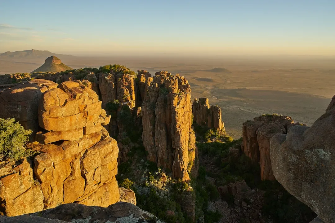
- Pass the spectacular "Madonna and Her Child" rock formation
- Navigate around the Mnweni Cutback, a massive indentation in the escarpment that offers dizzying views into the Mnweni Valley below
- The Mnweni area is often considered the most beautiful and "wild" part of the Drakensberg
- Camp near the Mponjwane (Rock of the Little Mule) or seek out Ledger's Cave, famous for its incredible sunrise views
Day 4: Mnweni to Rockeries / Ntonjelana Area
- Distance: 14 km
- Elevation gain: 700 m
- Time: 6–7 hours
- Continue south, passing the "Rockeries" and "Orange Peel Gap"
- The route crosses several high ridges and alpine valleys where you are likely to encounter Basotho shepherds
- The views toward the Cathedral Peak range start to dominate the southern horizon
- This area is known for its high-altitude wetlands (sponges); be prepared for boggy ground
- Camp near the top of the Ntonjelana Pass or find a sheltered spot in the upper valleys
Day 5: Ntonjelana to Cathedral Peak Hotel (via Mlambonja Pass)
- Distance: 13 km
- Elevation loss: 1,500 m
- Time: 6–8 hours
- Navigate toward the "Bell" and "Cathedral Peak" massifs
- Begin the long, knee-jarring descent down the Mlambonja Pass
- The path is steep and rocky, dropping from the basalt escarpment down into the sandstone "Little Berg"
- As you descend, the vegetation changes from alpine grasses to protea savannah and eventually lush riverine forest
- Finish at the Cathedral Peak Hotel or the nearby Ezemvelo KZN Wildlife office
- Celebrate the completion of the traverse with a cold drink and a view back up at the peaks you just conquered
Important Notes:
- Distances are estimates; actual distance covered depends heavily on your choice of line and navigation
- There are no marked trails on the escarpment; a GPS with pre-loaded waypoints is highly recommended
- Water can be scarce in dry winters; always fill up at major river crossings
- The descent on Day 5 is extremely taxing on the joints; trekking poles are essential
- Ensure you have arranged a shuttle or transport between Cathedral Peak and Sentinel Car Park in advance
Planning and Bookings
Book Your Trip
Everything you need to plan your journey
Accommodation
Find places to stay near Bergville
Flights
Search flights to Bergville
Essential Preparation
The North Drakensberg Traverse is a serious undertaking that requires meticulous planning. Unlike many other famous treks, there is no central booking system for the "trail" itself because there is no formal trail. However, you must coordinate your entry and exit points. The logistics of the traverse are complicated by the fact that the start (Sentinel) and finish (Cathedral Peak) are several hours apart by road. Most hikers base themselves in the town of Bergville or at one of the lodges in the Northern Drakensberg (like Witsieshoek Mountain Lodge) and arrange a private shuttle for the vehicle drop-off.
Physical fitness is non-negotiable. You will be carrying a heavy pack (15–20 kg) at altitudes where oxygen is noticeably thinner. Training should include multi-day hikes with a weighted pack and cardiovascular conditioning. Furthermore, at least one member of your group must be proficient in mountain navigation using a map, compass, and GPS. The "Berg" is no place to learn how to read a topographic map for the first time.
Trail Accommodation
There are no huts, lodges, or formal campsites on the high escarpment. Accommodation consists entirely of wild camping or staying in natural rock caves. This is one of the unique charms of the Drakensberg, but it requires specific knowledge and preparation.
Caves:
- Notable caves include Crow's Nest (near Amphitheatre), Ifidi Cave, and the legendary Ledger's Cave.
- Caves offer excellent protection from wind and rain but can be damp and cold.
- Caves must be "booked" by noting your intention in the Mountain Register at the trailhead, but this does not guarantee exclusivity. It is first-come, first-served.
- Always have a tent as a backup, as caves can be difficult to find in the mist or may already be occupied.
Wild Camping:
- You can pitch a tent almost anywhere on the escarpment, provided you are at least 100 metres away from water sources.
- Look for "sheltered" spots behind ridges to protect against high winds.
- The ground is often rocky or boggy; a high-quality, durable groundsheet is recommended.
Costs: There are no accommodation fees for the escarpment, but you must pay daily hiking fees and overnight permits to Ezemvelo KZN Wildlife (approximately R100–R150 per person per day).
Required Gear
- Four-season tent: Must be able to withstand high winds and potential snow. A lightweight but sturdy mountain tent is essential.
- Navigation: Topographic maps (Slingsby Maps are the gold standard), a reliable compass, and a GPS unit with spare batteries.
- Footwear: High-quality, waterproof hiking boots with excellent ankle support. The terrain is uneven and rocky.
- Backpack: 65–75L capacity with a robust harness system to carry 4–6 days of supplies.
- Sleeping Bag: Rated to at least -5°C (comfort rating), even in shoulder seasons. In winter, a -10°C bag is necessary.
- Trekking Poles: Essential for the steep ascents and the massive 1,500 m descent on the final day.
- Stove: Multi-fuel or canister stove. Note that gas canisters perform less efficiently at high altitudes and in cold temperatures.
What to Bring
- Food: Lightweight, high-calorie dehydrated meals. Bring an extra day's worth of food in case of weather delays.
- Water Treatment: While many streams on the escarpment are pristine, water near Basotho kraals should be treated with a filter or purification tablets.
- Clothing Layers: Merino wool base layers, a heavy fleece or down jacket, and a high-quality waterproof/windproof shell (Gore-Tex or similar).
- Sun Protection: High-SPF sunscreen, lip balm, and a wide-brimmed hat. The UV radiation at 3,000 m is intense.
- First Aid: Include blister care, rehydration salts, and any personal medications. A whistle and signal mirror are also important.
- Power Bank: To keep your GPS and phone (for emergencies) charged. Cold temperatures drain batteries quickly.
- Trowel: For proper disposal of human waste in accordance with Leave No Trace principles.
Permits
Permits for the North Drakensberg Traverse are managed by Ezemvelo KZN Wildlife. Unlike the strict quota systems of some international trails, permits are generally available, but the administrative process is vital for your safety. You do not "book" the trail months in advance, but you must register and pay before you start.
The Mountain Register: This is the most critical part of the permit process. At the Sentinel Car Park (or Witsieshoek), you must fill out the Mountain Register. You provide your planned route, intended cave stays, group size, and expected return date. If you do not sign out at the end of your hike, this register triggers a search and rescue operation. Be as detailed as possible.
Permit Costs:
- Daily hiking/overnight fee: Approximately R120 per person, per night (subject to annual increases).
- Sentinel Car Park/Royal Natal Entry Fee: A small per-person and per-vehicle fee is payable at the gate.
- Community Fees: If passing through the Mnweni area (which is tribal land, not Ezemvelo land), a small voluntary contribution to the Mnweni Hiking Centre is encouraged to support local conservation and mountain safety.
Logistics and Shuttles: Because the traverse is a point-to-point route, you will need to arrange transport. Most hikers leave their vehicle at the finish point (Cathedral Peak Hotel or Ezemvelo office) and take a pre-arranged shuttle to the start (Sentinel). This ensures your car is waiting for you when you finish. Several local operators in Bergville and the Northern Berg offer these shuttle services, but they must be booked at least a week in advance.
Other Activities in the Area
The Drakensberg region offers a wealth of experiences for those with extra time or for non-hiking companions:
- Royal Natal National Park: Explore the lower trails of the Amphitheatre, visit the Cascades, or take a shorter day hike to the base of the Tugela Falls.
- San Rock Art Tours: Visit Main Caves at Giant's Castle or the Didima Rock Art Centre at Cathedral Peak for a guided look at the ancient paintings and San history.
- Fly Fishing: Many of the rivers in the lower Berg are world-class trout fishing destinations.
- Canopy Tours: Experience the indigenous forests of the Central Berg from a series of zip-lines in the Blue Grotto valley.
- Falcon Ridge Bird of Prey Centre: Watch spectacular flight displays of rehabilitated raptors, including eagles and vultures, near Champagne Castle.
- Hot Air Ballooning: For a completely different perspective, take a sunrise flight over the foothills of the Drakensberg.
Safety and Conditions
Weather and Lightning: Lightning is the primary environmental hazard in the Drakensberg. During summer, storms typically build in the afternoon. If you hear thunder or see clouds building, move off high ridges and away from the escarpment edge immediately. Do not seek shelter in small, shallow caves during a lightning storm, as the current can travel through the rock. In winter, hypothermia is the main risk; ensure your layering system is robust and your sleeping bag is adequate.
Navigation and Mist: The "Berg juice" (thick mist) can reduce visibility to less than five metres. In these conditions, it is incredibly easy to become disoriented and walk off the edge of the escarpment or down the wrong pass into Lesotho. If the mist becomes too thick to navigate safely, the best course of action is to pitch your tent and wait for it to clear. Never attempt to "push through" if you are unsure of your position.
Security and Basotho Interactions: You will encounter Basotho shepherds on the plateau. Most interactions are friendly or neutral. However, there have been isolated incidents of theft or harassment. To stay safe: hike in a group of at least three or four, keep your gear inside your tent at night, and be polite but firm. Avoid giving money or sweets to children, as this encourages begging and can lead to aggressive behaviour toward future hikers. If you feel uncomfortable, move your campsite to a more secluded area.
Emergency Procedures: Cell phone reception is extremely spotty on the escarpment. It is strongest at the very edge of the cliffs overlooking South Africa and non-existent once you move a few hundred metres into Lesotho. Carrying a Satellite Phone or a Personal Locator Beacon (PLB) is highly recommended. In the event of an emergency, contact the Mountain Club of South Africa (MCSA) Search and Rescue. Ensure someone at home has your full itinerary and the emergency contact numbers.
Side Trips and Points of Interest
Tugela Falls: While the traverse passes the lip of the falls, taking an hour to explore the various viewpoints along the Amphitheatre wall is essential. The falls drop a total of 948 metres in five distinct leaps. Standing at the top and watching the water disappear into the abyss is a highlight of the trip. In winter, the falls can freeze into a massive pillar of ice.
Mount-Aux-Sources: A short detour from the main route on Day 2 takes you to the summit of Mount-Aux-Sources (3,282 m). While not the highest peak in the range, it is a significant hydrological point where the Tugela, Vaal, and Orange rivers all have their origins. The summit offers a 360-degree view of the plateau.
Mnweni Cutback and Ledger's Cave: The Mnweni area is the most rugged part of the traverse. Ledger's Cave is perched right on the edge of the escarpment and offers what many consider the best sunrise view in the entire Drakensberg. The "Cutback" itself is a massive horseshoe-shaped indentation that showcases the sheer power of erosion on the basalt cliffs.
The Bell and Cathedral Peak: On the final day, the route passes beneath the "Bell," a freestanding basalt spire that is a classic of South African rock climbing. If you have an extra day and the energy, a non-technical scramble to the summit of Cathedral Peak (3,004 m) provides a spectacular vantage point over the entire Central and Northern Drakensberg.
Leave No Trace
The Drakensberg escarpment is a fragile alpine environment. The thin soils and extreme weather mean that human impact can last for decades. As a UNESCO World Heritage site, it is our collective responsibility to keep it pristine.
Key LNT Principles for the Traverse:
- Pack it in, pack it out: This includes all trash, food scraps, and even organic waste like orange peels or nut shells, which decompose very slowly at high altitudes.
- Human Waste: Use a trowel to bury waste at least 15 centimetres deep and at least 100 metres from any water source. Pack out your used toilet paper in a sealed bag.
- Water Protection: Do not use soap (even biodegradable soap) directly in streams. Collect water and wash at least 30 metres away from the source.
- No Fires: Fires are strictly prohibited on the escarpment. Use a camping stove for all cooking. Fires destroy slow-growing alpine vegetation and pose a massive risk of runaway mountain fires.
- Respect the Silence: Keep noise to a minimum to avoid disturbing wildlife and other hikers seeking solitude.
- Leave what you find: Do not remove rocks, plants, or any historical artefacts. If you find San rock art in the lower sections, never touch the paintings, as the oils from your skin cause them to deteriorate.