
North Downs Way - A Journey Through English Countryside
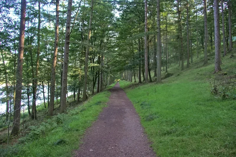
The North Downs Way is a long-distance footpath stretching 246 kilometres across the varied landscapes of southern England. This iconic trail traverses rolling chalk hills, ancient woodlands, historic market towns, and picturesque villages, offering a diverse and rewarding walking experience. From the historic Farnham in Surrey to the White Cliffs of Dover in Kent, the North Downs Way provides a captivating journey through quintessentially English scenery, rich in history and natural beauty. It is a trail that can be enjoyed in its entirety as a multi-day trek or explored in shorter sections, making it accessible to walkers of all abilities and time commitments.
- Distance: 246 km one-way
- Duration: 10–12 days
- Season: April–October (best weather, wildflowers, and longer daylight hours)
- Difficulty: Moderate
- Highest point: Near Titsey (approx. 260 m)
- Terrain: Varied – chalk ridges, woodland paths, country lanes, some road walking
- Direction: West to East (Farnham to Dover)
Overview
The North Downs Way is a National Trail that follows the chalk ridge of the North Downs from Farnham in Surrey to Dover in Kent. It is a route that offers a delightful blend of natural beauty and historical significance. The trail is divided into two main sections: the Surrey section, which is more undulating and woodland-rich, and the Kent section, which is generally flatter but features more open chalk downs and coastal scenery.
The western end of the trail begins in Farnham, a historic market town with a Norman castle. From here, the path winds through the Surrey Hills Area of Outstanding Natural Beauty, passing through charming villages like Shere and Dorking. The route ascends the chalk escarpment, offering panoramic views across the Weald to the south and towards London to the north. Highlights include Box Hill, a National Trust property renowned for its stunning views and diverse flora, and the ancient yew trees of Yew Hill.
As the trail enters Kent, the landscape changes, becoming more open with vast chalk downs. The route passes through picturesque villages such as Otford and Rochester, with its impressive cathedral and castle. Further east, the trail traverses the North Kent Downs Area of Outstanding Natural Beauty, offering expansive views and a sense of wildness. The final stretch leads to the iconic White Cliffs of Dover, a dramatic and fitting conclusion to this classic English walk.
The North Downs Way is well-signposted and maintained, making it suitable for both experienced long-distance hikers and those looking for shorter day walks. The trail is accessible by public transport at various points, and accommodation options range from traditional pubs with rooms to bed and breakfasts and hotels in towns and villages along the route.
History and Cultural Context
The North Downs Way follows ancient routes that have been used by humans for millennia. The chalk ridge itself provided a natural highway, offering drier and more easily traversable terrain than the marshy lowlands to the north and south. Evidence of prehistoric activity, including Neolithic flint mines and Iron Age hill forts, can be found along the route, testament to its long human history.
Roman roads, such as Stane Street, often ran parallel to or crossed the North Downs, connecting important settlements like Londinium (London) with the south coast. The trail passes through areas that were strategically important throughout history, with numerous castles, churches, and historic houses dotting the landscape. The Norman conquest left a significant mark, with castles built at Farnham, Rochester, and Dover to assert control over the region.
During medieval times, the North Downs were a vital route for pilgrims travelling to Canterbury Cathedral, following in the footsteps of Thomas Becket. While the North Downs Way doesn't directly follow the Pilgrims' Way, it often runs in close proximity, sharing some of its historical resonance. The trail also passes through areas that played a role in more recent conflicts, including World War II defences and airfields.
The designation of the North Downs Way as a National Trail in 1978 recognised its outstanding natural beauty and historical importance. It was created to provide a continuous walking route that showcases the diverse character of the North Downs, connecting communities and offering a unique perspective on England's rural heritage.
Seasonal Highlights and Weather Reality
The North Downs Way can be walked year-round, but the most pleasant times are generally from April to October. During these months, the weather is typically milder, daylight hours are longer, and the countryside is at its most vibrant.
Spring (April–May): This is a beautiful time to walk the trail. Wildflowers begin to bloom, particularly on the chalk downs, creating a colourful spectacle. Bluebells carpet the woodlands, and the air is fresh and invigorating. The weather can be variable, with a mix of sunshine and showers, but temperatures are generally pleasant.
Summer (June–August): The longest days and warmest temperatures make summer an ideal season for completing the entire trail. The downs are often bathed in sunshine, and the views can be spectacular. However, summer can also bring periods of hot weather, and some sections of the trail can be exposed and lack shade. Sandflies can be present in damper woodland areas, though they are less of an issue than in some other regions.
Autumn (September–October): Autumn offers a different kind of beauty, with the changing colours of the leaves in the woodlands creating a stunning display. The weather is often crisp and clear, with fewer crowds than in summer. This is a great time for photography and enjoying the tranquillity of the countryside.
Winter (November–March): While the trail is still accessible in winter, conditions can be more challenging. Days are short, and the weather can be cold, wet, and windy. Mud can be prevalent on woodland paths, and some sections may be less appealing due to the lack of foliage. However, winter can offer a sense of solitude and a stark beauty, with frost-covered landscapes and clear, crisp air on good days.
Weather Considerations: The weather in southern England can be unpredictable at any time of year. It is essential to be prepared for all conditions, including rain, wind, and sunshine, even on the same day. Layering clothing is recommended, and waterproofs are a must.
Recommended Itinerary
10-Day North Downs Way Itinerary (West to East)
Day 1: Farnham to Guildford
- Distance: 16 km
- Elevation gain: 200 m
- Time: 4–5 hours
- Start at Farnham Station
- Follow signs through Farnham town, past Farnham Castle
- Pass through woodland and open countryside
- Arrive in Guildford, a historic county town
- Key Waypoints: Farnham Castle, River Wey
Day 2: Guildford to Box Hill
- Distance: 22 km
- Elevation gain: 350 m
- Time: 6–7 hours
- Ascend towards the North Downs ridge
- Pass through charming villages like East Horsley
- Reach the National Trust property at Box Hill
- Key Waypoints: St Martha's Hill, Ranmore Common, Box Hill viewpoint
Day 3: Box Hill to Oxted
- Distance: 18 km
- Elevation gain: 250 m
- Time: 5–6 hours
- Continue along the chalk ridge
- Pass through woodland and open downland
- Arrive in the town of Oxted
- Key Waypoints: Denbies Wine Estate (nearby), Betchworth Castle ruins (nearby)
Day 4: Oxted to Westerham
- Distance: 15 km
- Elevation gain: 200 m
- Time: 4–5 hours
- Follow the Downs towards the Kent border
- Pass through picturesque countryside
- Arrive in the historic town of Westerham
- Key Waypoints: Titsey Hill, Chartwell (nearby - Winston Churchill's home)
Day 5: Westerham to Otford
- Distance: 17 km
- Elevation gain: 250 m
- Time: 5–6 hours
- Continue east along the Downs
- Pass through villages and farmland
- Arrive in the village of Otford
- Key Waypoints: Toys Hill, River Darent
Day 6: Otford to Rochester
- Distance: 20 km
- Elevation gain: 200 m
- Time: 6–7 hours
- Follow the trail towards the Medway Estuary
- Pass through more open downland and woodland
- Arrive in the historic city of Rochester
- Key Waypoints: Shoreham, River Medway
Day 7: Rochester to Detling
- Distance: 18 km
- Elevation gain: 200 m
- Time: 5–6 hours
- Leave Rochester and head towards the Kent Downs
- Pass through agricultural land and small hamlets
- Arrive in the village of Detling
- Key Waypoints: Bluebell Woods (seasonal), Kit's Coty (nearby - Neolithic long barrow)
Day 8: Detling to Hollingbourne
- Distance: 15 km
- Elevation gain: 150 m
- Time: 4–5 hours
- Continue along the North Downs ridge
- Pass through chalk quarries and open countryside
- Arrive in the village of Hollingbourne
- Key Waypoints: Thurnham Castle ruins (nearby)
Day 9: Hollingbourne to Wye
- Distance: 20 km
- Elevation gain: 250 m
- Time: 6–7 hours
- Follow the trail through rolling hills
- Pass through picturesque villages and farmland
- Arrive in the village of Wye
- Key Waypoints: The Pilgrims' Way (parallel), Wye Crown (hillside chalk figure)
Day 10: Wye to Dover
- Distance: 25 km
- Elevation gain: 300 m
- Time: 7–8 hours
- Final stretch towards the coast
- Pass through more open downland and woodland
- Reach the iconic White Cliffs of Dover
- End at Dover Priory Station
- Key Waypoints: Lydden, Dover Castle, White Cliffs of Dover
Alternative Itinerary (12 Days): For a more relaxed pace, consider extending the itinerary by splitting longer days or adding rest days in key locations like Guildford, Rochester, or Canterbury (a short detour from the main trail).
Planning and Bookings
Book Your Trip
Everything you need to plan your journey
Accommodation
Find places to stay near Farnham
Flights
Search flights to Farnham
Essential Preparation
The North Downs Way is a well-established trail, but thorough planning is still essential for an enjoyable experience. Consider your fitness levels and the time you have available. The trail is generally moderate, but some sections involve sustained ascents and descents along the chalk ridge. It's advisable to break the trail into manageable daily stages, considering accommodation availability and transport links.
Logistics: The trail is accessible by public transport at numerous points, with train stations in Farnham, Guildford, Dorking, Oxted, Rochester, and Dover, among others. This allows for flexible start and end points and the possibility of day trips or shorter sections. If walking the entire trail, arrange transport back from Dover to your starting point or home.
Base Towns/Cities:
- Farnham: The western trailhead, offering good transport links and accommodation options.
- Guildford: A larger town with a cathedral, castle, and a wide range of amenities, a good stopping point after the first couple of days.
- Rochester: A historic city with a prominent cathedral and castle, offering a significant cultural stop.
- Dover: The eastern terminus, famous for its White Cliffs and ferry port, providing onward travel connections.
Booking accommodation in advance is highly recommended, especially during peak season (summer) and weekends, as popular villages and towns can fill up quickly.
Trail Accommodation
Accommodation options along the North Downs Way are varied and generally plentiful, particularly in the towns and larger villages. There are no specific "trail huts" in the same way as some mountain routes; instead, walkers rely on conventional lodging.
Types of Accommodation:
- B&Bs and Guesthouses: Numerous small, family-run establishments offering a personal touch.
- Hotels: Available in larger towns like Guildford, Rochester, and Dover, offering a range of comfort levels and prices.
- Pubs with Rooms: A classic English option, providing a cosy atmosphere and often hearty meals.
- Self-Catering Cottages: Suitable for groups or longer stays, offering more independence.
- Campsites: While not as common directly on the trail, campsites can be found in the vicinity of some villages. Booking is usually required.
Booking Requirements: Advance booking is strongly advised, especially for weekends and during the summer months. Websites like Booking.com, Airbnb, and specific accommodation provider sites are useful resources.
Facilities Provided: Varies by establishment, but typically includes beds, private bathrooms, and breakfast (for B&Bs and hotels). Pubs offer food and drink.
What's NOT Provided: No specific trail facilities like communal cooking areas or designated shelters are provided. You will need to arrange your own meals unless staying at a hotel or pub that offers them.
Seasonal Availability: Most accommodation is available year-round, though some smaller establishments may have reduced hours or closures during the winter months.
Costs: Prices vary significantly based on location, type of accommodation, and time of year. Expect to pay approximately £70-£150 per night for a double room in a B&B or mid-range hotel. Campsites are typically £20-£30 per night.
Note: This is a day hike requiring no overnight accommodation. (This statement is for day hike templates and is not applicable here.)
Required Gear
- Sturdy Walking Boots: Waterproof and well broken-in, with good ankle support.
- Waterproof Jacket: Essential for unpredictable British weather.
- Waterproof Overtrousers: To keep legs dry during rain showers.
- Backpack: A comfortable daypack (20-30 litres) for day hikes, or a larger pack (45-65 litres) for multi-day treks.
- Navigation: Ordnance Survey (OS) maps (Explorer series recommended for detail), compass, and a GPS device or smartphone with offline mapping apps (e.g., OS Maps, Komoot).
- First-Aid Kit: Including blister plasters, antiseptic wipes, pain relievers, and any personal medications.
- Head Torch: With spare batteries, useful for early starts or late finishes, especially in winter.
- Sun Protection: Sunscreen, sunglasses, and a hat, even on cloudy days.
- Insect Repellent: Particularly useful for woodland sections during warmer months.
What to Bring
- Food and Water: Plenty of water (at least 1.5-2 litres per person per day), snacks, and packed lunches. Shops and pubs are available in most villages, but it's wise to carry supplies for longer stretches.
- Clothing: Layers are key. Include moisture-wicking base layers, insulating mid-layers (fleece or down), and comfortable walking trousers.
- Spare Socks: Essential for comfort and preventing blisters.
- Trekking Poles: Optional, but can be helpful for ascents and descents, especially on uneven terrain.
- Mobile Phone: For emergencies and navigation (ensure it's fully charged).
- Power Bank: To keep your phone or GPS device charged on longer days.
- Camera: To capture the beautiful scenery.
- Small Towel: If using campsites or budget accommodation.
- Toilet Paper and Hand Sanitiser: For use when facilities are not available.
Permits
No permits are required to walk the North Downs Way. As a National Trail, it is open access land, and you are free to walk it without needing special permission. This makes it a very accessible long-distance trail for both UK residents and international visitors.
However, some areas adjacent to the trail, such as National Trust properties (e.g., Box Hill) or private estates, may have their own access rules or opening times. It is always advisable to check local signage or websites if you plan to deviate significantly from the main trail or visit specific attractions.
Booking Accommodation: While no permits are needed for the trail itself, booking accommodation in advance is crucial, especially during peak seasons (summer holidays, weekends) and in popular locations. This is the primary "booking" requirement for a successful trip.
Transport: If using public transport, ensure you have appropriate tickets or passes. For those driving, parking availability can vary; research parking options in your chosen start and end points.
Other Activities in the Area
The North Downs Way passes through or near many areas offering additional activities and attractions:
- Historic Castles and Cathedrals: Explore Farnham Castle, Rochester Cathedral and Castle, and Dover Castle, each offering a glimpse into England's rich history.
- National Trust Properties: Visit Box Hill for its stunning views and walking trails, or Chartwell, the former home of Winston Churchill, near Westerham.
- Gardens and Parks: Discover beautiful gardens and parks in towns and villages along the route, such as those in Guildford or the gardens at Sissinghurst Castle (a slight detour from the main trail).
- Vineyards: The chalky soil of the North Downs is ideal for viticulture. Visit local vineyards for wine tasting tours, such as Denbies Wine Estate near Dorking.
- Museums and Galleries: Many towns have local museums showcasing regional history and art.
- Cycling: The North Downs Way is also popular with cyclists, with many parallel cycle routes and bridleways available.
- Birdwatching: The varied habitats along the trail, from woodlands to chalk downs and coastal areas, attract a wide range of bird species.
- Water Sports: The River Medway and the coast near Dover offer opportunities for kayaking, sailing, and other water activities.
Safety and Conditions
Trail Conditions: The North Downs Way is generally well-maintained and clearly signposted. However, conditions can vary:
- Mud: Woodland sections can become very muddy after rain, especially during autumn and winter. Wear appropriate footwear and be prepared for slippery conditions.
- Exposed Sections: The chalk downs can be exposed to wind and sun. Be prepared for changing weather and carry adequate sun protection.
- Road Crossings: The trail crosses numerous roads, some of which can be busy. Always exercise caution when crossing and obey traffic signals.
- Navigation: While the trail is well-signed, it is always advisable to carry maps and a compass or use a reliable GPS device, especially in poor visibility or if you plan to take detours.
Weather: British weather is notoriously changeable. Be prepared for rain, wind, and sunshine, often within the same day. Check the forecast before you set out and pack accordingly. Hypothermia is a risk in cold, wet conditions, even in summer.
Wildlife: While generally benign, be aware of your surroundings. Ticks can be present in grassy and woodland areas, especially during warmer months; check yourself for ticks after walking. Adders, the UK's only venomous snake, are rare but can be encountered in sunny, open habitats; give them plenty of space if seen.
Emergency Contacts:
- In a life-threatening emergency, dial 999 or 112 for the UK emergency services.
- Carry a fully charged mobile phone.
- Inform someone of your walking plans, including your intended route and expected return time.
- Consider joining a mountain rescue association or carrying a personal locator beacon if walking in remote areas or during challenging conditions.
Health: Stay hydrated and carry sufficient food and snacks to maintain energy levels. Take regular breaks and listen to your body. Blisters are a common ailment; ensure you have good footwear and blister treatment supplies.
Side Trips and Points of Interest
St Martha's Hill: A prominent viewpoint near Guildford, topped by a picturesque medieval church. Offers excellent panoramic views of the surrounding countryside.
Box Hill: A National Trust property renowned for its natural beauty and extensive network of walking trails. The viewpoint offers sweeping vistas across the Weald.
Denbies Wine Estate: Located near Dorking, this is England's largest single-estate vineyard. Visitors can take tours, enjoy wine tastings, and dine at the on-site restaurant.
Chartwell: The former country home of Sir Winston Churchill, located near Westerham. The house and gardens are open to the public and offer a fascinating insight into his life.
Rochester Cathedral and Castle: Two of the most significant historical landmarks in Kent. The cathedral is one of the oldest in England, and the castle is a magnificent example of Norman architecture.
Kit's Coty: A Neolithic long barrow near Detling, a significant prehistoric monument offering a connection to the ancient past of the region.
The Pilgrims' Way: While the North Downs Way often runs parallel to, or shares sections with, the ancient Pilgrims' Way, it's worth noting this historic route to Canterbury Cathedral. Some sections offer opportunities to explore this historical path.
Wye Crown: A large chalk figure cut into the hillside above the village of Wye, offering a distinctive landmark and a rewarding short climb for views.
White Cliffs of Dover: The iconic natural landmark that marks the end of the trail. The dramatic white chalk cliffs are a symbol of England and offer spectacular coastal views.
Leave No Trace
The North Downs Way traverses a landscape that is both beautiful and ecologically sensitive. Adhering to Leave No Trace principles ensures that the trail remains enjoyable for future generations and that the natural environment is protected.
Plan Ahead and Prepare: Research your route, check weather forecasts, and book accommodation in advance. Understand the terrain and your own capabilities.
Travel and Camp on Durable Surfaces: Stick to the marked paths and trails. Avoid walking on fragile vegetation, especially in woodland areas or on chalk downland where plants can be easily damaged.
Dispose of Waste Properly: Pack out everything you pack in, including all litter, food scraps, and wrappers. Use designated bins where available, but be prepared to carry your rubbish until you find one. Use toilet facilities in villages and towns; if wild toileting is unavoidable, do so at least 30 metres away from water sources and bury human waste.
Leave What You Find: Do not disturb or remove natural objects such as flowers, rocks, or historical artefacts. Take only photographs and memories.
Minimise Campfire Impacts: Campfires are generally not permitted on the North Downs Way, especially in designated camping areas or on sensitive downland. If camping, use a lightweight stove for cooking.
Respect Wildlife: Observe wildlife from a distance and never feed wild animals. This can disrupt their natural behaviour and diet.
Be Considerate of Other Visitors: Keep noise levels down, especially in quiet areas. Yield to other walkers, cyclists, and horse riders where appropriate. Respect the local communities you pass through.