Nakasendo Trail - The Historic Samurai Road of Japan
The Nakasendo Trail, or the "Central Mountain Route," is one of Japan’s most significant historical arteries, stretching 534 kilometres between the ancient capital of Kyoto and the modern metropolis of Tokyo (formerly Edo). Unlike the coastal Tokaido road, which was often plagued by flooding rivers and maritime hazards, the Nakasendo offered a rugged, inland alternative through the mountainous heart of Honshu. Today, it remains a premier thru-hiking destination for those seeking to traverse the soul of Japan, passing through 69 historic "juku" or post towns that served as vital rest stops for feudal lords, samurai, and merchants during the Edo period (1603–1868). The trail is a living museum, where meticulously preserved wooden architecture, ancient cobblestone paths (ishidatami), and mist-shrouded cedar forests provide a profound connection to Japan’s feudal past. While much of the original route has been absorbed by modern infrastructure, significant stretches—particularly through the Kiso Valley—remain remarkably untouched, offering a walking experience that is as much a cultural pilgrimage as it is a physical challenge.
- Distance: 534.0 km total (thru-hike)
- Duration: 10–14 days
- Elevation Gain: Approximately 8,000 m total
- Difficulty: Moderate (long distances but generally well-graded paths)
- Best Time: Spring (April–May) or Autumn (October–November)
- Highest Point: Torii Pass (1,197 m)
- Accommodation: Traditional Ryokans, Minshuku, and Business Hotels
- Direction: Traditionally walked from Kyoto to Tokyo, but equally popular in reverse
Overview
The Nakasendo Trail is a masterclass in cultural immersion, offering a transition from the refined elegance of Kyoto’s temples to the neon-lit intensity of Tokyo, with a vast, mountainous wilderness in between. The route is defined by its 69 post towns, which were established by the Tokugawa Shogunate to facilitate the "sankin-kotai" system—a political requirement where feudal lords (daimyo) were forced to travel between their domains and Edo every other year. This constant flow of high-ranking officials, accompanied by massive retinues of samurai, necessitated a sophisticated network of inns, tea houses, and stables. Today, walking the Nakasendo allows travellers to experience this history at a human pace, moving through landscapes that inspired the woodblock prints of Hiroshige and Eisen.
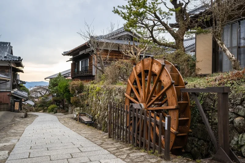
The trail’s character shifts dramatically across its length. The western sections near Kyoto and the eastern approaches to Tokyo are largely urbanised, requiring navigation through modern suburbs and alongside railway lines. However, the central portion—specifically the Kiso Valley in Nagano Prefecture—is the trail’s undisputed crown jewel. Here, the mountains press close, and the path winds through deep forests of Japanese cypress (hinoki) and cedar. Towns like Magome, Tsumago, and Narai have been designated as Nationally Important Preservation Districts for Groups of Traditional Buildings. In these villages, power lines are buried, cars are restricted, and the wooden facades of the buildings remain exactly as they appeared two centuries ago. Walking between these towns feels like stepping through a portal into the 17th century.
Physically, the Nakasendo is accessible to most fit walkers. While the total elevation gain is significant, the climbs are rarely technical. The challenge lies in the cumulative distance and the variety of surfaces, ranging from ancient stone-paved paths to modern asphalt. The infrastructure for hikers is exceptional, with frequent access to trains, convenience stores, and high-quality accommodation. However, the true essence of the Nakasendo is found in the quiet moments: the sound of a bear bell echoing in the woods, the steam rising from a roadside onsen, and the hospitality of a family-run minshuku serving local mountain vegetables and river fish. It is a journey that rewards curiosity and rewards those who take the time to look beyond the modern veneer of Japan.
History and Cultural Context
The Nakasendo was formally established in the early 17th century as one of the Gokaido—the five officially sanctioned highways connecting the Shogunate’s capital in Edo with the rest of Japan. While the Tokaido was the most famous and heavily travelled, the Nakasendo was often preferred by women and high-ranking officials because it avoided the dangerous river crossings of the coast, which could be closed for weeks during typhoon season. It was known as the "Hime Kaido" or "Princess Highway" because many high-born women, including imperial princesses travelling to Edo for political marriages, chose this inland route.
The post towns (juku) were the lifeblood of the trail. Each town was strictly organised according to social hierarchy. The "Honjin" was the most prestigious inn, reserved exclusively for daimyo, imperial envoys, and high-ranking officials. The "Wakihonjin" served as a secondary high-class inn, while "Hatago" provided accommodation for common travellers. The architecture of these towns—characterised by dark wood, sliding shoji screens, and overhanging eaves—was designed to withstand the heavy snows of the Japanese Alps while providing a welcoming atmosphere for weary travellers. The preservation of these towns today is a testament to local communities who, in the 1960s and 70s, fought to protect their heritage from the rapid modernisation sweeping the country.
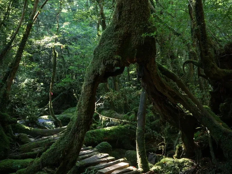
Culturally, the Nakasendo is steeped in the philosophy of "wabi-sabi"—the beauty of the imperfect, impermanent, and incomplete. This is evident in the moss-covered stone Buddhas (Jizo) that line the path, placed there to protect travellers, and the "Kosatsuba" noticeboards that once displayed the Shogun’s strict edicts. The trail also played a role in the Meiji Restoration; as Japan opened to the West, the Nakasendo saw the passage of the last samurai and the first Western explorers. Today, walking the trail is an act of "satoyama"—living in harmony with the mountain landscape—and hikers are encouraged to respect the deep spiritual and historical roots of the land.
Want more background? Read extended notes on history and cultural context → Learn more
Seasonal Highlights and Weather Reality
Choosing the right season is critical for a successful Nakasendo thru-hike. The Japanese climate varies significantly between the coastal plains and the high mountain passes of Nagano.
Spring (April–May): This is arguably the most popular time to walk. The cherry blossoms (sakura) bloom in Kyoto in early April and gradually move up the mountains, reaching the Kiso Valley by mid-to-late April. The weather is generally mild, with temperatures ranging from 10°C to 20°C, though rain is common. The landscape is a vibrant green, and the mountain air is crisp and clear. However, this is also the busiest season, particularly during "Golden Week" (late April to early May), when accommodation must be booked months in advance.
Autumn (October–November): For many, autumn is the superior season. The "koyo" (autumn foliage) transforms the maple and cherry trees into a riot of red, orange, and gold. The weather is more stable than in spring, with lower humidity and many clear, sunny days. Temperatures are cool and comfortable for walking, though they can drop toward freezing at night in the higher post towns like Narai. The harvest season also means local delicacies like chestnuts (kuri) and persimmons are at their peak.
Summer (June–August): Walking the Nakasendo in summer is a test of endurance. Japan’s summers are notoriously hot and humid, with temperatures frequently exceeding 30°C and humidity levels making it feel much hotter. June is the "tsuyu" (rainy season), bringing persistent, heavy downpours. While the forests are lush and the mountain streams are refreshing, the risk of heatstroke and the sheer discomfort of walking in high humidity make this the least recommended time for a thru-hike.
Winter (December–March): The Kiso Valley receives significant snowfall, and many of the mountain passes, such as the Torii Pass, can become treacherous without proper winter gear and experience. While the sight of Tsumago or Magome under a blanket of snow is magical, many local inns and restaurants close for the season, and the days are very short. This is only recommended for experienced winter hikers who are prepared for sub-zero temperatures.
Recommended Itinerary
11-Day Nakasendo Thru-Hike Itinerary
Day 1: Kyoto (Sanjo Ohashi) to Kusatsu
- Distance: 26 km
- Elevation gain: 150 m
- Time: 6–7 hours
- Start at Sanjo Ohashi bridge, the traditional western terminus
- Navigate through the eastern suburbs of Kyoto
- Pass through Otsu, the first post town on the route
- Walk alongside Lake Biwa, Japan's largest freshwater lake
- Arrive in Kusatsu, where the Nakasendo and Tokaido roads once met
- Stay in a local business hotel or guesthouse
Day 2: Kusatsu to Hikone
- Distance: 32 km
- Elevation gain: 200 m
- Time: 8–9 hours
- A long day through the Shiga plains
- Pass through the post towns of Moriyama and Musa
- The path follows a mix of old roads and modern cycling paths
- Arrive in Hikone, famous for its original 17th-century castle
- Explore the castle grounds and the historic district near the lake
Day 3: Hikone to Sekigahara
- Distance: 28 km
- Elevation gain: 400 m
- Time: 7–8 hours
- Enter the mountains separating Shiga and Gifu prefectures
- Pass through Samegai, known for its crystal-clear spring water and rare underwater flowers
- Cross the border into Gifu at the Kashiwabara post town
- Arrive in Sekigahara, the site of the most famous battle in Japanese history (1600)
- Visit the battlefield memorials and the local museum
Day 4: Sekigahara to Gifu City
- Distance: 30 km
- Elevation gain: 100 m
- Time: 7–8 hours
- Descend into the Nobi Plain
- Pass through the post towns of Tarui and Akasaka
- Cross the Ibi and Nagara Rivers
- Arrive in Gifu City, overlooked by Gifu Castle on Mount Kinka
- In summer, witness the traditional cormorant fishing (ukai) on the Nagara River
Day 5: Gifu City to Nakatsugawa
- Distance: 35 km (or take a short train segment to save time)
- Elevation gain: 300 m
- Time: 8–9 hours
- The landscape begins to transition toward the Kiso Mountains
- Pass through Mitake and Hosokute post towns
- The path becomes more rural and forested
- Arrive in Nakatsugawa, a major gateway to the Kiso Valley
- Sample the local "kuri-kinton" (chestnut sweets)
Day 6: Nakatsugawa to Tsumago via Magome
- Distance: 18 km
- Elevation gain: 600 m
- Time: 5–6 hours
- The most iconic section of the entire trail
- Steep climb from Nakatsugawa to Magome-juku
- Walk the "ishidatami" (cobblestones) of Magome
- Cross the Magome Pass (801 m) and descend into Tsumago-juku
- Tsumago is arguably the best-preserved post town in Japan
- Stay in a traditional minshuku for an authentic Edo-period experience
Day 7: Tsumago to Kiso-Fukushima
- Distance: 22 km
- Elevation gain: 500 m
- Time: 6–7 hours
- Follow the Kiso River upstream through deep gorges
- Pass through Nojiri and Suhara post towns
- Visit the Josho-ji Temple in Suhara
- Arrive in Kiso-Fukushima, a historic checkpoint (sekisho) town
- Enjoy a footbath (ashiyu) in the town centre overlooking the river
Day 8: Kiso-Fukushima to Narai via Torii Pass
- Distance: 20 km
- Elevation gain: 700 m
- Time: 6–7 hours
- Climb to the Torii Pass (1,197 m), the highest and most challenging point of the trail
- The pass is named after the Shinto gate that offers views toward Mount Ontake
- Descend into Narai-juku, known as "Narai of a Thousand Houses"
- The town features a long stretch of beautifully preserved wooden buildings
- Stay in a historic inn and explore the local lacquerware shops
Day 9: Narai to Shimosuwa
- Distance: 24 km
- Elevation gain: 400 m
- Time: 6–7 hours
- Leave the Kiso Valley and enter the Suwa Basin
- Pass through Shiojiri, a major junction for the Nakasendo
- Arrive in Shimosuwa, located on the shores of Lake Suwa
- Visit the Suwa Taisha, one of the oldest Shinto shrines in Japan
- Soak in the town's famous hot springs (onsen)
Day 10: Shimosuwa to Karuizawa
- Distance: 30 km (mountainous terrain)
- Elevation gain: 800 m
- Time: 8–9 hours
- Cross the Wada Pass (1,531 m), another significant climb
- Pass through the remote highland post towns of Wada and Mochizuki
- The scenery opens up into the volcanic landscapes of Nagano
- Arrive in Karuizawa, a popular mountain resort town
- Contrast the historic trail with the town's modern boutiques and cafes
Day 11: Karuizawa to Tokyo (Nihonbashi)
- Distance: 25 km (final walking segment) + Train
- Elevation gain: 100 m
- Time: 6–7 hours
- Descend from the Usui Pass toward the Kanto Plain
- Pass through Sakamoto and Annaka post towns
- Most hikers take the Shinkansen (bullet train) from Takasaki to Tokyo to finish
- Walk the final few kilometres through Tokyo to Nihonbashi bridge
- Nihonbashi is the official "Kilometre Zero" for all of Japan's historic highways
- Celebrate the completion of the 534 km journey in the heart of the capital
Planning and Bookings
Book Your Trip
Everything you need to plan your journey
Accommodation
Find places to stay near Tokyo
Flights
Search flights to Tokyo
Essential Preparation
Planning a Nakasendo thru-hike requires a blend of physical preparation and logistical coordination. While the trail is well-marked, a basic understanding of Japanese geography and culture is invaluable. Fitness requirements are moderate; you should be comfortable walking 20–30 kilometres per day for multiple consecutive days. Training should include hill walking to prepare for the mountain passes in the Kiso Valley.
Logistically, the "Takkyubin" (luggage forwarding service) is a game-changer. Most hikers send their main bags ahead to their next accommodation, carrying only a daypack with essentials. This service is reliable, affordable, and available at almost every convenience store and hotel. Base yourself in Kyoto for a few days before starting to acclimatise and finalise your gear. Ensure you have a working SIM card or portable WiFi, as Google Maps and translation apps are essential for navigating urban sections and reading menus.
Trail Accommodation
Accommodation on the Nakasendo ranges from luxury ryokans to humble minshuku and modern business hotels. In the historic post towns, staying in a traditional inn is a highlight of the trip.
Ryokans and Minshuku: These traditional Japanese inns provide tatami-mat rooms, futon bedding, and communal baths (often onsen). Most include "kaiseki" (multi-course) dinners and traditional breakfasts featuring local ingredients.
- Booking: Essential, especially in Tsumago, Magome, and Narai. Book 3–6 months in advance for peak seasons.
- Facilities: Shared toilets and baths are common in older buildings. Yukata (robes) are provided.
- Costs: Expect to pay 12,000–20,000 JPY per person per night, including two meals.
- Etiquette: Remove shoes at the entrance; follow strict bathing rituals in the onsen.
Business Hotels: Found in larger cities like Gifu, Nakatsugawa, and Shiojiri. These offer Western-style rooms, private bathrooms, and lower prices (6,000–10,000 JPY). They are convenient for "rest days" or when traditional inns are full.
What's NOT provided: Most traditional inns do not have laundry facilities or WiFi in rooms. They also have strict check-in times (usually by 5:00 PM) to ensure you are present for dinner.
Required Gear
- Walking Shoes/Boots: Lightweight hiking shoes or trail runners are ideal. The trail includes a lot of asphalt, so cushioning is more important than heavy-duty ankle support.
- Rain Gear: A high-quality waterproof jacket and a lightweight umbrella (very common in Japan).
- Daypack: 20–30L pack with a rain cover if using luggage forwarding.
- Clothing: Moisture-wicking layers. Avoid cotton. Bring a warm fleece or down jacket for cool mountain evenings.
- Navigation: Offline maps (Maps.me or Google Maps) and a physical guidebook (e.g., "Walking the Nakasendo" by Cicerone).
- Bear Bell: Essential for the Kiso Valley sections to alert local Asiatic black bears of your presence.
- Power Bank: To keep your phone charged for navigation and translation.
What to Bring
- Cash: Japan is still a cash-heavy society, especially in rural post towns. Many minshuku do not accept credit cards. Carry at least 50,000–100,000 JPY in cash for a thru-hike.
- Portable WiFi/SIM: Essential for navigation and communication.
- Small Towel: For use at footbaths (ashiyu) and public baths.
- Hand Sanitiser and Tissues: Public toilets are clean but don't always provide paper or soap.
- Personal Medications: Japanese pharmacies may not carry the same brands or strengths as your home country.
- Reusable Water Bottle: Tap water in Japan is safe to drink, and there are many public fountains and vending machines.
- Plastic Bags: For carrying your own trash, as public bins are rare in Japan.
Permits
One of the greatest advantages of the Nakasendo Trail is that no official permits are required to walk the route. It is a public right-of-way, and you are free to walk as much or as little as you like. However, there are several "cultural permits" and logistical bookings that function as the framework for your journey.
Accommodation Bookings: While not a permit, your accommodation confirmations are the most critical "documents" you will carry. In the Kiso Valley, the number of beds is strictly limited to preserve the historic character of the towns. If you arrive without a booking, you may be forced to take a train to a nearby city to find a hotel, breaking the continuity of your walk.
The Nakasendo Stamp Book: A popular tradition for hikers is to purchase a "Shuincho" or a dedicated Nakasendo stamp book. At each of the 69 post towns, you can find unique rubber stamps (usually at the local tourist office or museum) to commemorate your visit. While not a legal requirement, completing the book is a badge of honour for thru-hikers.
Checkpoint Museums: Some historic checkpoints (sekisho), like the one in Kiso-Fukushima, charge a small entry fee (300–500 JPY). These are well worth the cost to understand the strict travel regulations that once governed the trail.
Luggage Forwarding (Takkyubin): This service is booked day-by-day. You fill out a waybill at your hotel front desk or a convenience store. The cost is typically 1,500–2,500 JPY per bag. Ensure you have the address of your next destination written in Japanese to assist the staff.
Other Activities in the Area
The Nakasendo passes through some of Japan's most culturally rich regions. Consider these additions to your itinerary:
- Onsen Hopping: Beyond the trailside baths, visit famous hot spring towns like Gero Onsen (near the trail in Gifu) or the historic baths of Shimosuwa.
- Sake Brewery Tours: The Kiso Valley is famous for its pure mountain water, which produces exceptional sake. Many breweries in towns like Narai and Kiso-Fukushima offer tastings.
- Castle Visits: Hikone Castle and Inuyama Castle are two of Japan's few remaining original castles and are easily accessible from the trail.
- Zen Meditation: Many temples along the route, particularly in Kyoto and the Kiso Valley, offer "Zazen" sessions for visitors.
- Traditional Crafts: Participate in a lacquerware workshop in Narai or learn the art of "hinoki" (cypress) woodworking in Tsumago.
- Mount Ontake: For experienced hikers, a multi-day detour to climb this sacred volcano offers spectacular views and a deep spiritual experience.
Safety and Conditions
Wildlife (Bears): The Kiso Valley is home to the Asiatic black bear. While they are generally shy, encounters can happen. Use a bear bell (suzu) on your pack, especially when walking alone or in dense forest. If you see a bear, do not run; back away slowly and maintain eye contact. Most trailheads have "bear bells" installed on posts—give them a loud ring as you pass.
Weather Extremes: Japan is prone to typhoons from August to October. These can bring torrential rain, landslides, and flooding. Always check the Japan Meteorological Agency (JMA) website for warnings. In summer, heat exhaustion is a genuine risk; drink plenty of fluids and use the ubiquitous vending machines to stay hydrated.
Road Safety: Significant portions of the Nakasendo follow modern roads. While Japanese drivers are generally polite, some sections have narrow shoulders. Wear bright clothing and stay alert. In urban areas, follow the "Old Nakasendo" signs (often small blue or wooden markers) to stay off the main highways where possible.
Emergency Services: The emergency number in Japan is 119 for fire and ambulance, and 110 for police. Most operators do not speak fluent English, so having a translation app or a card with your location written in Japanese is vital. Travel insurance that covers medical evacuation is highly recommended.
Side Trips and Points of Interest
The Torii Pass: Located between Yabuhara and Narai, this is the spiritual heart of the Nakasendo. The climb is steep but rewarded with a massive stone torii gate and a small shrine. On a clear day, you can see the snow-capped peak of Mount Ontake, one of Japan's three most sacred mountains. The forest here is ancient, with massive cedar trees that have stood since the time of the samurai.
The Magome-Tsumago Trail: Even if you don't do the full thru-hike, this 8 km section is a must. It features the "Male and Female Waterfalls" (Odaki and Medaki), where legend says the swordsman Miyamoto Musashi once meditated. The path is beautifully maintained with stone paving and offers the quintessential Nakasendo experience.
Narai-juku: Known as the "town of a thousand houses," Narai was the wealthiest post town on the route. Its long, straight main street is lined with two-story wooden buildings that house inns, tea rooms, and shops. The Kiso-Ohashi, a massive arched wooden bridge made of 300-year-old cypress, is a stunning architectural feat located just outside the town centre.
Sekigahara Battlefield: For history buffs, this is the site of the 1600 battle that unified Japan under the Tokugawa Shogunate. You can walk to the various encampment sites of the famous generals, including Tokugawa Ieyasu and Ishida Mitsunari. The modern museum provides an excellent interactive overview of the conflict.
Leave No Trace
The Nakasendo is not just a wilderness trail; it is a cultural landscape where people have lived and worked for centuries. Practising Leave No Trace principles here involves both environmental and cultural respect.
Waste Management: Japan has very few public trash cans. You are expected to carry all your rubbish with you until you reach your accommodation or a convenience store where you are a customer. Never leave trash at shrines or trailheads.
Cultural Etiquette: Many parts of the trail pass through private property or quiet residential areas. Keep noise levels down, especially in the early morning. Always ask permission before taking photos of locals or the interior of private homes. Do not touch or lean on the historic wooden buildings, as the oils from your skin can damage the ancient wood.
Stay on the Path: In the forested sections, staying on the marked trail prevents erosion and protects the delicate mosses and ferns. In the post towns, stick to the designated walking routes to avoid disrupting the daily lives of the residents.
Respect the Shrines: When passing through a shrine or temple, walk to the side of the path (the centre is reserved for the gods) and refrain from loud conversation. If you choose to pray, follow the local custom: bow twice, clap twice, and bow once more.