
Mount Zeil Approach - Central Australia's Highest Peak
The Mount Zeil Approach is a challenging and remote trek in Australia's Northern Territory, leading to the summit of Mount Zeil, the highest point in the territory. This is not a marked or maintained trail in the conventional sense, but rather a route that requires navigation skills, self-sufficiency, and a high level of fitness. The journey takes you through rugged desert landscapes, ancient geological formations, and offers a profound sense of isolation and accomplishment. Unlike many popular hiking destinations, the Mount Zeil Approach demands meticulous planning and preparation due to its remote location, extreme weather conditions, and lack of facilities. It is a true expedition for experienced adventurers seeking to conquer the highest point in this vast and arid continent.
- Distance: Approximately 25.0 km (return)
- Elevation Gain: Approximately 700 m
- Duration: 2-3 days
- Difficulty: Challenging / Remote Expedition
- Best Time: May to September (cooler months)
- Highest point: Mount Zeil summit (1,531 m)
- Access: Via rough 4WD track from Alice Springs
- Permits: Not required, but notification of plans is essential
Overview
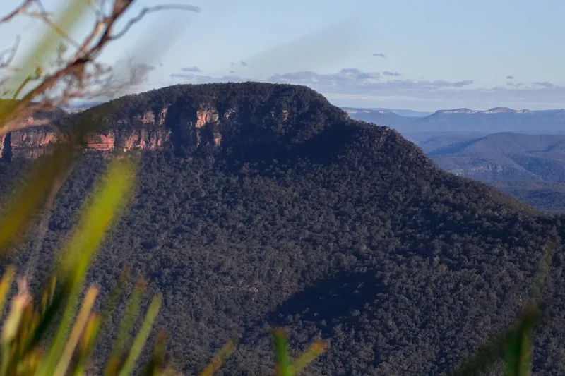
The Mount Zeil Approach is an expeditionary trek that culminates in the ascent of Mount Zeil, the highest peak in the Northern Territory of Australia, standing at 1,531 metres above sea level. This is a journey into the heart of the arid MacDonnell Ranges, a landscape characterised by ancient rock formations, sparse vegetation, and extreme temperatures. The route is not a designated walking track; instead, it involves navigating a rugged 4WD track for a significant portion and then bushwalking across challenging, unmarked terrain to reach the summit. The ascent is demanding, requiring a good level of physical fitness and robust navigation skills, as the path is often indistinct and the terrain can be steep and rocky.
The experience is defined by its remoteness and the raw beauty of the Australian desert. During the cooler months, typically from May to September, the days can be pleasant, but nights can drop to near freezing. Outside these months, temperatures can soar to extreme levels, making any attempt at this trek dangerous. The landscape is stark yet captivating, with vast panoramas of the surrounding ranges and plains. The summit of Mount Zeil offers unparalleled views, a fitting reward for the considerable effort involved in reaching it. This trek is for those who embrace self-reliance, enjoy the challenge of off-track navigation, and seek an authentic wilderness experience far from the beaten path.
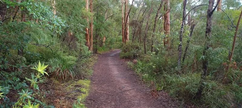
The journey typically begins with a drive from Alice Springs, requiring a high-clearance 4WD vehicle to access the trailhead. The initial part of the route follows a rough track, which can be challenging even for 4WDs, especially after rain. From the designated parking area, the trek begins in earnest. The path is a combination of the 4WD track and then a more adventurous bushwalk, often following dry creek beds and navigating through rocky outcrops. The final ascent to the summit involves scrambling over boulders and navigating steep, scree-covered slopes. The sense of achievement upon reaching the highest point in the Northern Territory is immense, offering a unique perspective on the vastness and ruggedness of the Australian outback.
History and Cultural Context
The MacDonnell Ranges, and specifically the area around Mount Zeil, have been the ancestral lands of Indigenous Australian peoples, particularly the Arrernte people, for tens of thousands of years. These ranges hold deep cultural and spiritual significance, with numerous sites of importance for ceremony, storytelling, and survival. The Arrernte people have a profound connection to this land, understanding its seasons, water sources, and the flora and fauna that sustain life. The name "Zeil" itself is of European origin, named by the German geologist and explorer Carl Strehlow in the late 19th or early 20th century, reflecting the period of European exploration and mapping of Central Australia.
Carl Strehlow was a key figure in documenting the Arrernte language and culture, and his expeditions into the ranges contributed to the geographical mapping of the region. Mount Zeil, as the highest point, would have been a significant landmark for Indigenous peoples and later for European explorers and surveyors. The development of the rough 4WD track leading towards the base of the mountain is a more recent phenomenon, born out of the need for access for geological surveys, pastoral activities, and eventually, recreational exploration. However, the area remains largely undeveloped, preserving its wild character and the ancient heritage of its traditional custodians.
The history of the Mount Zeil Approach is one of exploration, both by Indigenous peoples who have traversed these lands for millennia, and by European explorers and geologists who mapped and named the prominent features. It is a landscape that tells a story of deep time, geological forces, and enduring cultural connections. The trek itself is a modern interpretation of this exploration, offering a chance to experience the raw, untamed beauty of the Central Australian desert and to connect with a landscape that has been shaped by both natural forces and human history.
Seasonal Highlights and Weather Reality
The Mount Zeil Approach is a trek best undertaken during the cooler months of the year, from May to September. This period, often referred to as the "dry season" or "winter" in Central Australia, offers the most favourable conditions for desert trekking.
May to September (Cooler Months): This is the prime season for attempting the Mount Zeil trek. Daytime temperatures are generally pleasant, ranging from 15°C to 25°C, making hiking comfortable. However, temperatures can drop significantly overnight, often falling to between 0°C and 10°C, and occasionally below freezing. This necessitates warm sleeping gear and appropriate layers for early mornings and evenings. Rainfall is infrequent during this period, but when it does occur, it can transform the dry creek beds into fast-flowing watercourses, making some sections impassable. The skies are typically clear, offering excellent stargazing opportunities.
October to April (Hotter Months): This period is generally considered too hot and dangerous for attempting the Mount Zeil trek. Daytime temperatures frequently exceed 35°C and can reach well over 40°C. The risk of heatstroke, dehydration, and severe sunburn is extremely high. While thunderstorms can occur during this time, bringing some relief, they can also lead to flash floods in the dry creek beds, creating hazardous conditions. It is strongly advised to avoid this trek during the hotter months unless you are an extremely experienced desert trekker with specialised knowledge of heat management and survival.
Weather Variability: Even during the cooler months, desert weather can be unpredictable. Sudden changes in temperature, strong winds, and occasional rain showers can occur. It is crucial to monitor weather forecasts closely before and during your trek and to be prepared for a range of conditions.
Recommended Itinerary
2-3 Day Mount Zeil Approach Itinerary
Day 1: Alice Springs to Trailhead & Initial Ascent
- Early Morning: Depart Alice Springs in a high-clearance 4WD vehicle.
- Drive West: Travel west on Larapinta Drive, then turn onto the unsealed track towards Mount Zeil. This section is rough and requires careful driving.
- Trailhead Access: Reach the designated parking area (approx. 3-4 hours driving from Alice Springs). Ensure your vehicle is suitable and parked securely.
- Midday: Begin the trek. Initially, follow the rough 4WD track.
- Afternoon: Navigate off the 4WD track, likely following dry creek beds or faint animal tracks. Aim to reach a suitable campsite before dusk.
- Distance: Approx. 8-10 km (depending on campsite selection)
- Elevation Gain: Approx. 200-300 m
- Time: 4-6 hours (including driving and initial walking)
- Key Waypoints: Trailhead parking, junction with 4WD track, dry creek beds, potential campsite locations.
Day 2: Summit Ascent & Descent to Camp
- Early Morning: Break camp and begin the ascent towards Mount Zeil.
- Morning: Navigate through rocky terrain, dry creek beds, and potentially steep scree slopes. This section requires careful footing and navigation.
- Midday: Reach the summit of Mount Zeil (1,531 m). Enjoy the panoramic views of the surrounding MacDonnell Ranges.
- Afternoon: Begin the descent back towards your campsite from Day 1, or a slightly lower, more sheltered location if preferred.
- Distance: Approx. 10-12 km
- Elevation Gain: Approx. 400-500 m (ascent), similar descent
- Time: 6-8 hours
- Key Waypoints: Base of the main ascent, summit ridge, scree slopes, descent route.
Day 3: Return to Trailhead & Drive to Alice Springs
- Morning: Pack up camp and walk back along the 4WD track or dry creek beds to the trailhead.
- Late Morning: Arrive back at your vehicle.
- Midday: Drive back to Alice Springs.
- Distance: Approx. 5-7 km
- Elevation Gain: Minimal
- Time: 2-3 hours walking, plus 3-4 hours driving
- Key Waypoints: Campsite, trailhead parking.
Alternative 2-Day Itinerary (for highly experienced and fit trekkers):
- Day 1: Drive to trailhead, ascend to summit, descend to a lower camp or attempt to return to trailhead if time and energy permit.
- Day 2: Return to trailhead and drive to Alice Springs. This is a very demanding option.
Important Considerations:
- This is a remote, unmarked trek. Navigation skills are paramount.
- Carry sufficient water and food for the entire duration, plus an emergency buffer.
- Inform someone of your detailed itinerary and expected return time.
- Be prepared for extreme temperature fluctuations.
- High-clearance 4WD vehicle is essential for accessing the trailhead.
- No facilities are available on the track or at the summit.
Planning and Bookings
Book Your Trip
Everything you need to plan your journey
Accommodation
Find places to stay near Alice Springs
Flights
Search flights to Alice Springs
Essential Preparation
The Mount Zeil Approach is a serious undertaking that requires meticulous planning and a high degree of self-sufficiency. Due to its remote location and lack of facilities, thorough preparation is paramount for safety and enjoyment. This includes ensuring you have a suitable vehicle for accessing the trailhead, which is typically a rough 4WD track requiring high clearance and robust suspension. It is essential to inform a reliable contact person of your detailed itinerary, including your planned route, expected departure and return times, and emergency contact information. This person should be instructed to alert authorities if you do not check in by a specified time.
The closest major town and logistical hub is Alice Springs. This is where you will source all your supplies, fuel, and potentially hire a suitable 4WD vehicle if you do not own one. Alice Springs offers accommodation options ranging from budget hostels to hotels, as well as supermarkets, outdoor gear stores, and mechanics. Allow ample time in Alice Springs before and after your trek to finalise preparations, purchase supplies, and rest. Understanding the local climate and its extremes is critical; the cooler months (May to September) are the only recommended period for this trek due to the severe heat during the warmer months.
Trail Accommodation
This is a remote expedition requiring self-sufficient camping. There are no established huts, lodges, or campsites along the Mount Zeil Approach. Trekkers must carry all necessary camping equipment and be prepared to camp in the wilderness.
Camping:
- Location: Camp in designated areas away from water sources and fragile vegetation. Choose sheltered spots if possible, especially during cooler months to minimise exposure to wind.
- Facilities: None. You must carry in and pack out all waste, including human waste. Use a trowel to dig catholes at least 100 metres away from water sources, trails, and campsites.
- Booking Requirements: No bookings are required as this is an undeveloped wilderness area.
- Seasonal Availability: Camping is possible year-round, but highly discouraged during the hot season (October to April) due to extreme temperatures and associated risks.
- Costs: There are no costs associated with camping in this area.
This is a remote expedition requiring self-sufficient camping. No overnight accommodation is provided.
Required Gear
- High-clearance 4WD Vehicle: Essential for accessing the trailhead. Ensure it is in excellent mechanical condition and equipped for rough terrain.
- Navigation Tools: Topographic maps of the MacDonnell Ranges, a reliable compass, and a GPS device or smartphone with offline mapping capabilities (e.g., Gaia GPS, Maps.me). Practice using these tools before your trip.
- Backpack: A robust, comfortable backpack of 60-80 litres capacity to carry all your gear, food, and water. A rain cover is advisable.
- Tent: A sturdy, lightweight tent suitable for desert conditions, capable of withstanding wind.
- Sleeping Bag: A 0°C to -5°C comfort rated sleeping bag is recommended for cooler months, as temperatures can drop below freezing.
- Sleeping Mat: For insulation and comfort.
- Water Filter/Purifier: Essential for treating any water sources you may find. Carry a backup purification method (e.g., tablets).
- First-Aid Kit: Comprehensive kit including blister treatment, pain relief, antiseptic wipes, bandages, gauze, tape, and any personal medications.
- Head Torch: With spare batteries.
- Sun Protection: Wide-brimmed hat, sunglasses, high SPF sunscreen.
- Insect Repellent: For flies and other biting insects.
- Emergency Shelter: Lightweight emergency blanket or bivvy bag.
- Repair Kit: Duct tape, cordage, multi-tool, tent pole repair sleeve.
What to Bring
- Food: Sufficient non-perishable food for the duration of your trek, plus at least one extra day's supply for emergencies. Lightweight, high-energy meals are ideal.
- Water: Carry a minimum of 5-7 litres of water per person per day, depending on the season and expected conditions. Water sources are unreliable and may be contaminated.
- Cooking Gear: Lightweight camping stove, fuel, cooking pot, utensils, mug, plate/bowl.
- Toiletries: Biodegradable soap, toothbrush, toothpaste, toilet paper, hand sanitiser, trowel for digging catholes.
- Clothing:
- Moisture-wicking base layers (synthetic or merino wool)
- Insulating mid-layer (fleece or down jacket)
- Durable hiking trousers (quick-drying)
- Long-sleeved shirts for sun protection
- Warm hat and gloves for cold nights/mornings
- Sturdy, broken-in hiking boots
- Camp shoes or sandals
- Socks (multiple pairs, wool or synthetic)
- Communication Device: Satellite phone or Personal Locator Beacon (PLB) is highly recommended for remote areas with no mobile reception.
- Rubbish Bags: To pack out all waste.
- Camera and spare batteries/power bank.
- Book or journal for downtime.
Permits
No specific permits are required to access the Mount Zeil trailhead or to trek in the surrounding MacDonnell Ranges National Park. However, it is crucial to understand that this is a remote wilderness area, and while formal permits are not mandated, responsible behaviour and adherence to park guidelines are expected.
Key Considerations:
- Notification of Plans: While not a formal permit requirement, it is strongly advised and considered essential for safety to inform a reliable contact person of your detailed itinerary. This includes your planned route, expected departure and return dates, vehicle details, and emergency contact information. This person should be instructed to contact authorities if you fail to check in by a pre-arranged time.
- Park Regulations: Familiarise yourself with the general regulations for the MacDonnell Ranges National Park, which typically cover aspects such as fire restrictions, waste disposal, and camping practices. These are usually available from the Northern Territory Parks and Wildlife Commission website or visitor centres.
- Vehicle Access: Ensure your vehicle is suitable for the rough 4WD track. While no permit is needed for the track itself, driving off-road where not permitted is prohibited.
- Respect for Indigenous Heritage: The MacDonnell Ranges are culturally significant to the Arrernte people. Visitors are expected to treat the land with respect, avoid disturbing cultural sites, and adhere to any specific guidelines provided by local Indigenous organisations or park authorities.
The emphasis for this trek is on self-reliance and responsible wilderness ethics rather than formal permit acquisition. Your preparedness and communication of plans are your primary safety measures.
Other Activities in the Area
While the Mount Zeil Approach is a significant undertaking, the surrounding MacDonnell Ranges offer a wealth of other experiences for those interested in exploring the unique desert landscape of Central Australia:
- Larapinta Trail: This world-renowned long-distance walking track traverses the MacDonnell Ranges, offering a variety of day walks and multi-day sections. Sections like the ascent to Mount Sonder provide spectacular views and challenging terrain, though they are generally more well-marked than the Mount Zeil route.
- Alice Springs Desert Park: A fantastic place to learn about the flora, fauna, and cultural heritage of the desert. It offers excellent insights into the environment you will be trekking through.
- Simpsons Gap, Standley Chasm, and Ellery Creek Big Hole: These are popular and accessible natural attractions within the West MacDonnell Ranges, offering opportunities for short walks, swimming in waterholes (seasonal), and experiencing the dramatic desert scenery.
- Alice Springs Telegraph Station Historical Reserve: Explore the original site of the Alice Springs settlement and learn about the history of the Overland Telegraph Line.
- Arrernte Cultural Centre: Gain a deeper understanding of the local Indigenous culture, art, and history.
- Scenic Flights: Consider a scenic flight over the MacDonnell Ranges for a breathtaking aerial perspective of the vast desert landscape, including views of Mount Zeil and the surrounding ranges.
- Stargazing: The clear, dark skies of Central Australia offer unparalleled opportunities for stargazing. Away from the light pollution of towns, the Milky Way is a spectacular sight.
Safety and Conditions
Extreme Heat: The most significant hazard is the extreme heat, particularly during the warmer months (October to April). Daytime temperatures can exceed 40°C, leading to heatstroke, dehydration, and severe sunburn. Always check the forecast and avoid trekking during the hottest parts of the day. Carry significantly more water than you think you will need.
Water Scarcity: Water sources are unreliable and often dry. Do not depend on finding water along the route. Carry all the water you need for the entire trek, plus a substantial emergency reserve. Treat any water found rigorously.
Navigation: The Mount Zeil Approach is an unmarked route. Navigation skills are critical. The terrain can be disorienting, with dry creek beds and rocky outcrops that can lead you astray. Always carry and know how to use a map, compass, and GPS device. Inform someone of your plans.
Vehicle Access: The 4WD track to the trailhead is rough and can be impassable after rain. Ensure your vehicle is suitable, in good condition, and that you have appropriate recovery gear. Check track conditions before you depart Alice Springs.
Wildlife: While large dangerous animals are not a primary concern, be aware of snakes (venomous), spiders, and stinging insects. Wear sturdy footwear and be cautious where you place your hands and feet.
Communication: Mobile phone reception is non-existent in this remote area. A satellite phone or Personal Locator Beacon (PLB) is highly recommended for emergency communication.
Bushfires: Be aware of the risk of bushfires, especially during drier periods. Check fire bans and conditions before you go.
Physical Fitness: This trek requires a high level of physical fitness and endurance due to the challenging terrain, potential heat, and the need to carry all your supplies.
Emergency Plan: Have a clear emergency plan. Know what to do in case of injury, getting lost, or vehicle breakdown. Ensure your emergency contact person knows this plan.
Side Trips and Points of Interest
Mount Zeil Summit (1,531 m): The primary objective of this trek. Reaching the summit offers a profound sense of accomplishment and provides unparalleled panoramic views across the vast expanse of the MacDonnell Ranges and the surrounding desert plains. The summit area itself is rocky and exposed, offering a true sense of being on top of the world in this arid landscape. Allow time to soak in the views and appreciate the scale of the outback.
Rocky Creek Beds and Gorges: The route often follows dry creek beds and navigates through small gorges. These areas offer interesting geological formations, unique desert flora adapted to these microclimates, and a sense of exploration as you push deeper into the ranges. Keep an eye out for evidence of water flow and the hardy plant life that thrives here.
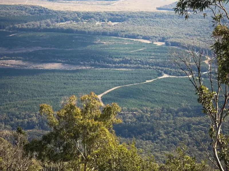
Panoramic Vistas: Even before reaching the summit, the trek offers numerous vantage points with sweeping views of the rugged, ancient landscape. The colours of the desert, the layered ranges, and the vast sky create a constantly changing and captivating panorama. These viewpoints are ideal for photography and for appreciating the immense scale of the Australian outback.
Unique Desert Flora and Fauna: While sparse, the desert is home to a surprising array of life. Keep an eye out for desert-adapted plants, lizards, birds of prey, and if you are very lucky, some of the larger mammals that inhabit the ranges. The resilience of life in this harsh environment is a point of interest in itself.
Leave No Trace
The Mount Zeil Approach traverses a fragile desert ecosystem. Adhering to Leave No Trace principles is paramount to preserving this environment for future generations and ensuring the safety of all visitors.
- Plan Ahead and Prepare: Thoroughly research the area, understand the conditions, and be prepared for self-sufficiency. Inform someone of your plans.
- Travel and Camp on Durable Surfaces: Stick to the 4WD track where possible and camp on established, bare ground or rock. Avoid walking on fragile vegetation.
- Dispose of Waste Properly: Pack out everything you pack in, including all food scraps, packaging, and toilet paper. Dig catholes at least 100 metres away from water sources, trails, and campsites for human waste.
- Leave What You Find: Do not remove any natural objects, rocks, or plants. Respect cultural heritage sites.
- Minimise Campfire Impacts: Campfires are generally discouraged in desert environments due to the risk of wildfires and the slow regeneration of vegetation. If permitted and necessary, use a designated fire ring or a portable stove. Ensure fires are completely extinguished.
- Respect Wildlife: Observe wildlife from a distance. Do not feed animals, as this can harm their health and alter their natural behaviours.
- Be Considerate of Other Visitors: While this is a remote trek, if you do encounter others, maintain a respectful distance and minimise noise.
By following these principles, you help protect the unique beauty and ecological integrity of the MacDonnell Ranges.
Useful Links
- Northern Territory Parks and Wildlife - MacDonnell Ranges National Park
- Tourism Australia - Alice Springs and Surrounds
- Department of Climate Change, Energy, the Environment and Water - MacDonnell Ranges National Park
- Bureau of Meteorology - Northern Territory Weather
- 4WD Action - Larapinta Drive (for context on regional tracks)