Mount Yarigatake Trek - The Crown Jewel of the Japanese Alps
The Mount Yarigatake Trek, often referred to as the Yari-ga-take hike, is a quintessential Japanese alpine adventure, renowned for its dramatic ridgelines, breathtaking panoramic views, and the iconic, spear-like summit of Mount Yarigatake itself. This challenging mountain track, located in the Northern Japan Alps (Chūbu Sangaku National Park), offers a multi-day immersion into a rugged, high-altitude environment. The route typically begins from the Kamikochi valley, a stunning glacial basin accessible by bus, and ascends through diverse alpine flora, past crystal-clear mountain streams, and over exposed ridges that demand respect and careful footing. The journey culminates at the summit of Yarigatake (3,180 metres), one of Japan's most celebrated peaks, offering unparalleled vistas of the surrounding mountain ranges.
- Distance: Approximately 22.0 km (one-way from Kamikochi to summit and return to Kamikochi, or as part of a longer traverse)
- Elevation Gain: Approximately 1,700 metres
- Duration: 2-3 days
- Difficulty: Challenging
- Best Time: July to September (when snow-free and huts are open)
- Closest City: Takayama
- Trailhead Access: Kamikochi Bus Terminal
- Highest Point: Mount Yarigatake Summit (3,180 m)
- Direction: Typically an out-and-back from Kamikochi, or part of a traverse
Overview
Mount Yarigatake is not merely a mountain; it is an icon of Japanese mountaineering. Its distinctive summit, resembling a spearhead, has drawn climbers and hikers for generations. The trek is a true test of endurance and a reward for those who seek the raw beauty of high alpine landscapes. Unlike the more manicured trails of some European Alps, the Yari-ga-take route is a rugged, often steep ascent that winds through dense forests at lower elevations before opening up to exposed alpine meadows and finally, rocky scree and boulder fields near the summit.
The journey typically starts in Kamikochi, a pristine valley often described as the "Japanese Yosemite." From here, the trail gradually ascends, following the Azusa River before branching off towards Yarigatake. The path is well-marked but can be demanding, with significant elevation gain over a relatively short distance. Hikers will encounter a variety of terrain, from soft forest paths to challenging rocky sections that require scrambling and careful navigation. The higher you climb, the more dramatic the scenery becomes, with sweeping views of the Northern Alps unfolding with every metre gained.
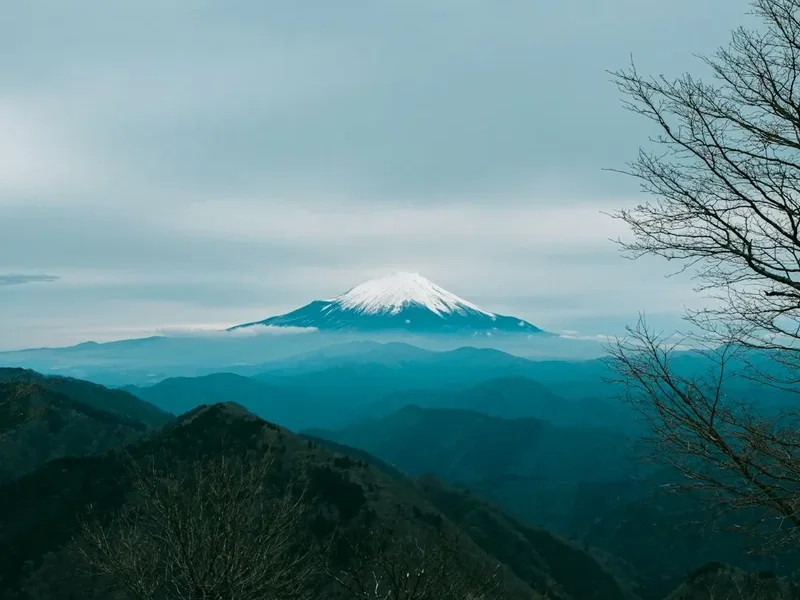
The summit of Yarigatake is a place of profound beauty and spiritual significance. The 360-degree panorama from the top is legendary, encompassing peaks like Hotakadake, Arakuradake, and the distant Mount Fuji on exceptionally clear days. The final approach to the summit involves a short, exposed climb using chains and ladders, adding an element of thrill to the ascent. The mountain huts along the route provide essential resting points, offering basic accommodation and sustenance, and fostering a sense of camaraderie among trekkers.
The best time to undertake this trek is during the summer months, from July to September, when the snow has melted, and the huts are operational. Even during this period, mountain weather can be unpredictable, with sudden storms, fog, and temperature drops being common. Therefore, thorough preparation and respect for the mountain environment are paramount for a safe and enjoyable experience.
History and Cultural Context
Mount Yarigatake has held cultural and spiritual significance for centuries. As part of the Northern Japan Alps, it has been a destination for ascetics and pilgrims seeking spiritual enlightenment in its formidable heights. The mountain's distinctive shape has inspired awe and reverence, making it a prominent feature in Japanese art and literature.
The modern era of mountaineering in Japan truly began in the late 19th and early 20th centuries, influenced by Western exploration and the establishment of organisations like the Japanese Alpine Club. Yarigatake, along with other major peaks like Mount Fuji and Mount Tateyama, became popular objectives for these early mountaineers. The development of trails and mountain huts facilitated access, transforming these challenging ascents into more accessible, albeit still demanding, treks.
The establishment of Chūbu Sangaku National Park in 1934 further protected the natural beauty and ecological integrity of the region, including Mount Yarigatake and its surrounding peaks. The park is a vital area for biodiversity, home to unique alpine flora and fauna, and its preservation remains a key focus for conservation efforts.
Today, Yarigatake is one of Japan's most popular mountains, attracting thousands of hikers each year. It is considered one of Japan's 37°Camous Mountains, a list compiled by mountaineer Kyūya Fukada in 1964, which highlights the most significant and beautiful peaks in the country. The trek is not just a physical challenge but also a journey through a landscape rich in history, culture, and natural wonder.
Seasonal Highlights and Weather Reality
The Mount Yarigatake Trek is a seasonal undertaking, with the primary hiking window dictated by snow conditions and the operational status of mountain huts.
Summer (July to September): This is the peak season for hiking Yarigatake. The snow has largely melted from the main trails, and the mountain huts are open and staffed. The weather is generally more stable, with longer daylight hours. July can still see lingering snow patches, especially on north-facing slopes, and occasional thunderstorms. August and September offer the most reliable conditions, with clearer skies and pleasant temperatures, though still prone to rapid weather changes. This is also the busiest period, so expect company on the trails and at the huts.
Late Spring (June): While some hardy hikers may attempt Yarigatake in June, it is generally considered too early. Significant snow cover persists, especially at higher elevations, making navigation difficult and requiring advanced mountaineering skills, including the use of ice axes and crampons. Trails may be obscured, and avalanche risk can still be present.
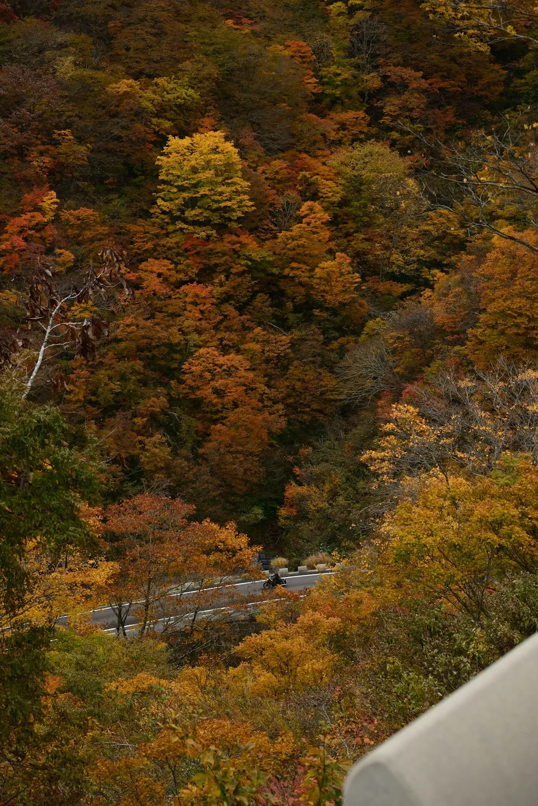
Autumn (October): As autumn progresses, temperatures begin to drop, and snow can fall at higher elevations. While early October can still offer good hiking days, the risk of encountering winter conditions increases significantly. Huts typically close by mid-October, and trails can become hazardous due to ice and snow. This season offers stunning autumn colours in the lower valleys but requires careful monitoring of weather forecasts and a higher degree of preparedness.
Winter (November to May): Mount Yarigatake is a serious winter mountaineering objective during these months. The trails are buried under deep snow, and the mountain is subject to extreme cold, high winds, and avalanche danger. Only experienced winter climbers with appropriate technical gear and knowledge should consider attempting the ascent during this period. The huts are generally closed, and no facilities are available.
Weather Considerations: Regardless of the season, mountain weather is notoriously unpredictable. Be prepared for rapid changes, including sudden fog, rain, hail, and strong winds, even on seemingly clear days. Hypothermia is a risk at high altitudes, so carrying appropriate layers is crucial.
Recommended Itinerary
2-Day Mount Yarigatake Trek (Intensive)
Day 1: Kamikochi to Yarigatake Sanso (or Goken Sanso)
- Distance: Approximately 10-12 km
- Elevation gain: Approximately 1,000-1,200 m
- Time: 6-8 hours
- Start from Kamikochi Bus Terminal (1,500 m)
- Walk through the scenic Kamikochi valley, following the Azusa River
- Pass Myojin Pond and Tokusawa
- Begin the ascent towards Yarigatake
- Trail becomes steeper, passing through forests and then into alpine terrain
- Reach Yarigatake Sanso (mountain hut near the summit, 3,080 m) or Goken Sanso (lower hut, 2,700 m)
- Settle into the hut, enjoy dinner, and prepare for an early summit attempt the next day
- The views from the huts are already spectacular, offering a preview of the summit panorama
Day 2: Summit Attempt and Descent to Kamikochi
- Distance: Approximately 10-12 km (return to Kamikochi)
- Elevation: Summit ascent (approx. 100 m), then 1,700 m descent
- Time: 7-9 hours (including summit time)
- Early morning start (pre-dawn) for sunrise summit attempt
- Final ascent to the summit of Mount Yarigatake (3,180 m)
- The last section involves a short, exposed climb using chains and ladders – requires careful footing and a head for heights
- Enjoy sunrise and panoramic views from the summit
- Descend back to Yarigatake Sanso (or Goken Sanso) for breakfast
- Continue the descent back to Kamikochi
- The descent can be as challenging as the ascent, especially on tired legs
- Arrive back at Kamikochi Bus Terminal in the afternoon
3-Day Mount Yarigatake Trek (More Relaxed)
Day 1: Kamikochi to Tokusawa (or Goken Sanso)
- Distance: Approximately 6-8 km
- Elevation gain: Approximately 300-500 m
- Time: 3-4 hours
- Start from Kamikochi Bus Terminal (1,500 m)
- Gentle walk through Kamikochi valley, enjoying the scenery
- Reach Tokusawa (1,570 m) or continue to Goken Sanso (2,700 m) for a more substantial first day
- Set up camp (if applicable) or check into the hut
- Enjoy a more leisurely pace and acclimatise
Day 2: Tokusawa (or Goken Sanso) to Yarigatake Sanso
- Distance: Approximately 6-8 km
- Elevation gain: Approximately 1,200-1,500 m
- Time: 5-7 hours
- Continue the ascent towards Yarigatake
- If starting from Tokusawa, this day involves significant elevation gain
- Reach Yarigatake Sanso (3,080 m)
- Settle in and prepare for the summit push
Day 3: Summit Attempt and Descent to Kamikochi
- Distance: Approximately 10-12 km (return to Kamikochi)
- Elevation: Summit ascent (approx. 100 m), then 1,700 m descent
- Time: 7-9 hours
- Early morning summit attempt
- Descend back to Kamikochi
Important Notes:
- Hut bookings are essential, especially during peak season. Book well in advance.
- The final ascent to the summit is exposed and requires careful navigation and a good head for heights.
- Weather can change rapidly; always be prepared for cold, wind, and rain.
- Carry sufficient water or a purification method, as water sources can be scarce at higher elevations.
- Respect the fragile alpine environment.
Planning and Bookings
Book Your Trip
Everything you need to plan your journey
Accommodation
Find places to stay near Takayama
Flights
Search flights to Takayama
Essential Preparation
Planning a trek to Mount Yarigatake requires careful coordination, especially regarding transport and accommodation. The primary gateway city is Takayama, a charming historic town known for its preserved Edo-period streets and morning markets. From Takayama, you will need to arrange transport to the Kamikochi valley, the main trailhead for Yarigatake.
Transport to Kamikochi:
- From Takayama: Take the Nohi Bus from Takayama Bus Terminal to the Kamikochi Bus Terminal. The journey takes approximately 1.5 to 2 hours and offers scenic views as you approach the mountains. Buses operate frequently during the hiking season.
- Parking: If travelling by car, parking is available in Takayama near the bus terminal. There is also limited parking in Sawando, from where you can take a shuttle bus to Kamikochi. Note that private vehicles are generally not allowed into the Kamikochi valley itself; access is restricted to buses and taxis.
Logistics:
- Accommodation in Takayama: Takayama offers a range of accommodation, from traditional ryokans to modern hotels and budget-friendly guesthouses. It is advisable to book accommodation in Takayama in advance, especially during peak tourist seasons.
- Food Supplies: While mountain huts offer meals, it is wise to carry some of your own snacks and energy bars. Supermarkets in Takayama can supply these items.
- Trailhead Information: Upon arrival at Kamikochi, visit the visitor centre for the latest trail conditions, weather updates, and any safety advisories.
Trail Accommodation
Accommodation on the Mount Yarigatake trek is primarily in mountain huts (yama-goya). These huts are strategically located along the route to provide shelter and sustenance for hikers. Booking in advance is highly recommended, especially during the peak season (July-September), as they can fill up quickly.
Key Mountain Huts:
- Yarigatake Sanso (槍ヶ岳山荘): Located just below the summit of Mount Yarigatake (3,080 m). This is a popular and well-equipped hut offering stunning views.
- Goken Sanso (五 th 槍本館): Situated at a lower elevation (2,700 m), it serves as a good stopping point for those on a more relaxed itinerary or as a base for the final ascent.
- Tokusawa (徳沢): A campsite and basic hut facility located in the lower valley, suitable for the first night of a 3-day trek.
Hut Facilities:
- Bunk beds with blankets (sleeping bags are usually required or can be rented).
- Communal dining areas.
- Basic meals (breakfast and dinner) are typically available for purchase.
- Toilets (often pit toilets or basic flush toilets).
- Access to water (usually from mountain streams; purification is recommended).
- No electricity for charging devices (bring a power bank).
What's NOT Provided:
- Personal toiletries.
- Towels.
- Sleeping bags (unless specified or rented).
- Cooking equipment or food supplies (beyond what the hut offers).
Seasonal Availability: Huts are generally open from late April/early May to mid-October, depending on the specific hut and snow conditions. It is crucial to check the opening and closing dates for the huts you plan to use.
Costs: Hut fees vary, but expect to pay approximately ¥8,000 - ¥10,000 per night for accommodation and a meal. Booking is usually done directly through the hut's website or via booking platforms.
Required Gear
- Hiking Boots: Sturdy, waterproof hiking boots with good ankle support are essential. Ensure they are well broken-in to prevent blisters.
- Waterproof Jacket and Trousers: High-quality, breathable waterproofs are critical due to the unpredictable mountain weather.
- Warm Layers: Multiple layers of synthetic or merino wool clothing (base layer, mid-layer fleece or down jacket, outer shell).
- Hat and Gloves: Even in summer, temperatures at altitude can be cold.
- Backpack: A comfortable backpack (40-60 litres) with a rain cover.
- Head Torch: Essential for early morning starts or if staying in huts without electricity. Bring spare batteries.
- Navigation Tools: Map of the area, compass, and a GPS device or smartphone with offline maps. While trails are generally well-marked, it's crucial to be prepared for poor visibility.
- First-Aid Kit: Comprehensive kit including blister treatment, pain relievers, antiseptic wipes, bandages, and any personal medications.
- Sun Protection: High SPF sunscreen, sunglasses, and a wide-brimmed hat. The sun at high altitudes is intense.
- Trekking Poles: Highly recommended for stability and to reduce strain on knees during ascents and descents.
What to Bring
- Food: High-energy snacks (nuts, dried fruit, energy bars), and sufficient food for lunches. If not planning to eat at huts, carry all meals.
- Water Bottles/Hydration Reservoir: Carry at least 2 litres of water per person.
- Water Purification Method: Water filters or purification tablets are recommended, as stream water, while plentiful, may not be safe to drink directly.
- Toiletries: Toothbrush, toothpaste, biodegradable soap, small towel, hand sanitiser.
- Personal Items: Camera, power bank for electronics, book or journal for downtime.
- Cash: Mountain huts may not accept credit cards, and it's useful for small purchases or emergencies.
- Plastic Bags: For packing out all rubbish, including food scraps and wrappers.
- Sleeping Bag Liner: Recommended for hygiene and added warmth in huts.
Permits
For the standard Mount Yarigatake trek starting from Kamikochi and staying in mountain huts, specific permits are generally not required for the trail itself. However, access to Kamikochi is regulated, and there is an entrance fee.
Kamikochi Entrance Fee:
- A fee is charged for entry into the Kamikochi valley. This fee contributes to the maintenance and preservation of the area. The exact amount can vary, but it is typically around ¥1,000 per person. This fee is usually paid at the entrance gate or when purchasing your bus ticket.
Mountain Hut Reservations:
- While not a permit in the traditional sense, booking accommodation in the mountain huts is essential and effectively acts as your permission to stay overnight. These reservations are critical, especially during the peak season (July-September), as huts have limited capacity and are often fully booked months in advance.
- Reservations are typically made directly through the website of each mountain hut. It is advisable to book as soon as your travel dates are confirmed.
National Park Regulations:
- As part of Chūbu Sangaku National Park, visitors are expected to adhere to park regulations. These generally include rules about waste disposal, camping (only in designated areas, if permitted), and respecting wildlife.
- There are no specific permits required for day hiking or for the standard multi-day trek if staying in the designated huts. However, if you plan to undertake more technical routes or expeditions, specific permits might be necessary. Always check with the park authorities or relevant mountaineering associations for the most up-to-date information.
Important Considerations:
- Book Huts Early: This cannot be stressed enough. Popular huts like Yarigatake Sanso book out very quickly.
- Check Opening Dates: Ensure the huts you intend to stay in are open for your planned dates.
- No Wild Camping: Wild camping is generally not permitted within Kamikochi or on the main trails leading to Yarigatake. Stick to designated campsites or book huts.
Other Activities in the Area
The region surrounding Mount Yarigatake and Kamikochi offers a wealth of activities for nature enthusiasts and cultural explorers:
- Exploring Kamikochi Valley: Before or after your trek, spend time exploring the pristine Kamikochi valley itself. Walk along the Azusa River, visit the iconic Kappa Bridge, and enjoy the serene atmosphere of Myojin Pond and Taisho Pond. The valley offers numerous easy walking trails suitable for all fitness levels.
- Hiking Other Peaks in the Northern Alps: Kamikochi serves as a gateway to many other spectacular peaks in the Northern Japan Alps. Consider extending your trip to hike Mount Hotakadake (the highest peak in the Northern Alps), Mount Maehotakadake, or Mount Maehotakadake. These routes often involve more technical climbing and require significant experience.
- Onsen (Hot Springs): After a strenuous hike, relax and rejuvenate in one of the many onsen facilities in the Takayama region or in towns closer to the mountains. These natural hot springs are a quintessential Japanese experience.
- Exploring Takayama: Immerse yourself in the history and culture of Takayama. Visit the Sanmachi Suji historic district with its preserved Edo-period merchant houses, explore the morning markets, and sample local delicacies like Hida beef and sake.
- Shirakawa-go and Gokayama: Take a day trip or an overnight stay in these UNESCO World Heritage villages, famous for their unique gassho-zukuri farmhouses with steep, thatched roofs designed to withstand heavy snowfall.
- Cycling: Rent a bicycle in Takayama or Kamikochi (where available) and explore the surrounding countryside at a more leisurely pace.
Safety and Conditions
Pre-Departure Checks:
- Weather Forecast: Always check the latest mountain weather forecast for the Northern Japan Alps (Chūbu Sangaku National Park) from reliable sources like the Japan Meteorological Agency (JMA) or specialized mountaineering weather services. Be aware that forecasts can change rapidly.
- Trail Conditions: Consult the Kamikochi Visitor Centre or relevant park authorities for up-to-date information on trail conditions, snow levels, and any closures. Websites of mountain huts may also provide updates.
- Emergency Contacts: Know the emergency contact numbers for the local police and mountain rescue services.
Altitude Sickness: Mount Yarigatake reaches an altitude of 3,180 metres. Altitude sickness (acute mountain sickness) can affect anyone, regardless of fitness level. Symptoms include headache, nausea, dizziness, and fatigue. Ascend gradually, stay hydrated, avoid alcohol, and listen to your body. If symptoms worsen, descend immediately.
Weather Hazards:
- Sudden Storms: Mountain weather can change dramatically and without warning. Be prepared for rain, strong winds, fog, and even snow, especially at higher elevations, even during summer.
- Hypothermia: Even in summer, temperatures at altitude can drop significantly, especially with wind chill. Always carry warm, waterproof, and windproof layers.
- Lightning: Avoid exposed ridges and summits during thunderstorms. Seek shelter in a hut or a designated safe area.
Trail Hazards:
- Steep and Exposed Sections: The final ascent to Yarigatake summit involves chains and ladders, which can be exposed and require a good head for heights. Be cautious and move deliberately.
- Slippery Surfaces: Rocks and trails can be slippery, especially after rain or when covered in snow or ice. Wear appropriate footwear and use trekking poles for stability.
- Navigation: While trails are generally well-marked, dense fog can reduce visibility to near zero. Always carry and know how to use a map and compass.
Sandflies: While not as notorious as in New Zealand's Fiordland, sandflies can be present in Kamikochi and at lower elevations, particularly near water. Carry insect repellent.
Communication: Mobile phone reception can be unreliable in mountainous areas. Consider carrying a personal locator beacon (PLB) or satellite communication device for emergencies.
Travel Insurance: Ensure your travel insurance covers high-altitude trekking and potential emergency evacuation.
Side Trips and Points of Interest
Yarigatake Summit (3,180 m): The ultimate destination. The final approach involves a short, steep climb using fixed chains and ladders, offering a thrilling conclusion to the trek. The summit itself is a small, rocky plateau with a shrine and a weather station. The panoramic views from the summit are legendary, providing a breathtaking 360-degree vista of the Japanese Alps.
Yarigatake Sanso (槍ヶ岳山荘): This mountain hut, located just below the summit, is a point of interest in itself. It offers a unique glimpse into the life of mountain hut operations in Japan and provides a comfortable base for summit attempts. The views from the hut's terrace are spectacular, especially at sunrise and sunset.
Goken Sanso (五 th 槍本館): Another significant mountain hut on the route, offering a different perspective and a good stopping point for those on a more extended itinerary. It's a place to rest, refuel, and interact with other hikers.
Kamikochi Valley: The starting point of the trek is a destination in its own right. Points of interest include:
- Kappa Bridge (河童橋): The iconic suspension bridge offering classic views of the Azusa River and the surrounding mountains, including Yarigatake.
- Myojin Pond (明神池): A beautiful, serene pond with a small shrine, accessible via a short walk from the main trail.
- Taisho Pond (大正池): Formed by a volcanic eruption, this pond offers a unique landscape with submerged trees, creating a hauntingly beautiful scene.
Azusa River: The crystal-clear Azusa River flows through Kamikochi and accompanies much of the initial ascent. Its vibrant turquoise waters are a constant source of beauty and a reminder of the pristine alpine environment.
Alpine Flora and Fauna: Keep an eye out for the unique alpine plants that bloom in the meadows during summer, such as alpine roses and various gentians. If you are lucky, you might spot Japanese serows or marmots.
Leave No Trace
The Mount Yarigatake Trek traverses a fragile alpine environment within Chūbu Sangaku National Park. Adhering to Leave No Trace principles is crucial to preserve its natural beauty and ecological integrity for future generations.
Your responsibility as a hiker:
- Plan Ahead and Prepare: Understand the regulations, weather, and terrain. Pack appropriately and be prepared for all conditions.
- Travel and Camp on Durable Surfaces: Stick to marked trails to avoid damaging vegetation. Use designated campsites or stay in mountain huts. Avoid creating new paths or campsites.
- Dispose of Waste Properly: Pack out everything you pack in, including all food scraps, wrappers, and toilet paper. Use designated toilets at huts and campsites. If no facilities are available, dig a cathole at least 60 metres away from water sources, trails, and campsites.
- Leave What You Find: Do not take rocks, plants, or any natural objects. Leave them for others to enjoy and for the ecosystem to thrive.
- Minimize Campfire Impacts: Campfires are generally prohibited in national parks and at high altitudes. Use a portable stove for cooking.
- Respect Wildlife: Observe wildlife from a distance. Do not feed animals, as it can disrupt their natural behaviours and diets. Store food securely to prevent attracting animals.
- Be Considerate of Other Visitors: Keep noise levels down, yield to uphill hikers, and maintain a respectful attitude towards fellow trekkers and the local culture.
By following these principles, you help ensure that the majestic beauty of Mount Yarigatake and the surrounding Alps remains unspoiled.