
Mount Wilhelm Summit - Papua New Guinea's Highest Peak
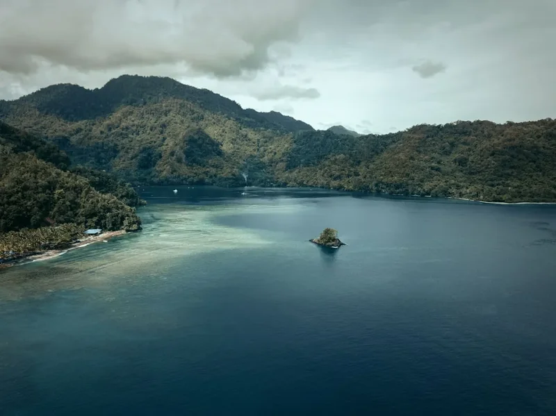
Mount Wilhelm, standing at an imposing 4,509 metres (4,508 m), is the highest mountain in Papua New Guinea and a significant peak in Oceania. Located in the Bismarck Range, straddling the Simbu and Madang provinces, its summit offers a challenging yet immensely rewarding trekking experience. The ascent traverses diverse ecological zones, from lush tropical rainforests and cloud forests to alpine grasslands and finally, the stark, rocky terrain of the upper slopes. This trek is not merely a physical challenge; it's a journey through a unique cultural landscape and a testament to the raw, untamed beauty of the New Guinean highlands. The air thins dramatically as you ascend, and the views from the summit, often above the clouds, are breathtaking, encompassing vast expanses of the surrounding mountainous terrain.
- Distance: Approximately 9.0 km one-way to summit from Keglsugl
- Elevation Gain: Approximately 2,200 m to summit
- Duration: 2-3 days (typical)
- Season: June to September (dry season)
- Difficulty: Challenging to Very Challenging
- Base Town: Kundiawa
- Trailhead Access: Keglsugl
- Highest Point: 4,509 m
- Accommodation: Basic huts/shelters at base camp and higher altitudes
Overview
The trek to Mount Wilhelm's summit is a serious undertaking, demanding a high level of fitness, acclimatisation, and preparedness. The journey typically begins at Keglsugl, a village situated at approximately 2,300 metres, which serves as the primary access point and registration area for the national park. From Keglsugl, the trail ascends steadily, passing through vibrant highland landscapes. The initial stages are often characterised by well-trodden paths through villages and agricultural land, where you might encounter local communities going about their daily lives. As you climb higher, the vegetation transitions dramatically.
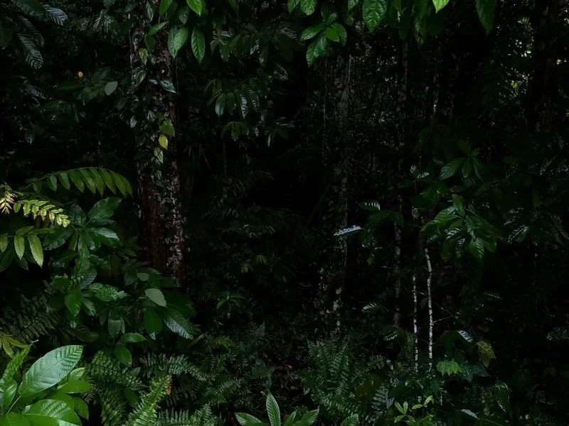
The lower slopes are dominated by dense tropical rainforest, alive with the sounds of exotic birds and insects. Further up, this gives way to moss-laden cloud forests, where the air is perpetually damp and the trees are draped in epiphytes. This zone is often shrouded in mist, creating an ethereal, almost mystical atmosphere. Beyond the cloud forest lies the alpine zone, a starkly beautiful landscape of tussock grasses, rocky outcrops, and scree slopes. This is where the air becomes noticeably thinner, and the physical demands of the trek intensify. The final push to the summit involves navigating rocky terrain, often requiring scrambling and careful foot placement. The summit itself is a relatively small, rocky plateau, marked by a cairn and often adorned with flags left by previous climbers.
The weather on Mount Wilhelm is notoriously unpredictable. While the dry season (June to September) offers the best chance of clear skies and stable conditions, sudden storms, heavy rain, and even snow can occur at any time, especially at higher altitudes. Temperatures can drop significantly, particularly at night and near the summit. Successful ascents rely heavily on good weather windows, proper acclimatisation, and robust physical conditioning. The cultural aspect of the trek is also significant; Mount Wilhelm is a sacred mountain for the local people, and respecting local customs and traditions is paramount.
History and Cultural Context
Mount Wilhelm holds profound cultural and spiritual significance for the indigenous peoples of the Papua New Guinean highlands, particularly the indigenous groups of the Simbu and Madang provinces. For generations, these mountains have been considered sacred sites, places of ancestral spirits and important ceremonial grounds. The local communities have a deep, intrinsic connection to the land, and their traditional knowledge of the mountain's flora, fauna, and weather patterns is extensive. The name "Wilhelm" was given by German explorer Otto Finsch in 1888, after the German Emperor Wilhelm II. However, the mountain has always had local names, such as "Enduwa Kombugl" or "Mount Wilhelm" in the local dialect, reflecting its importance in their cosmology and daily life.
The first recorded ascent to the summit by a European was by Austrian botanist and explorer Ludwig Schrader in 1936. His expedition, which included a team of local guides, successfully reached the summit, documenting the unique alpine flora and fauna. Following World War II, interest in the mountain grew, and it became a destination for mountaineers and adventurers. In the post-war era, the establishment of the Mount Wilhelm National Park aimed to protect its unique biodiversity and cultural heritage. The park was gazetted in 1972, covering an area of 39,000 hectares, and is part of the larger Bismarck-Ramu Conservation Area.
The trek to the summit has evolved from a purely exploratory or scientific endeavour to a popular, albeit challenging, adventure tourism activity. However, the cultural importance of the mountain remains central. Local guides, often from the villages surrounding the mountain, are essential for any successful and respectful ascent. They possess invaluable knowledge of the terrain, weather, and local customs, ensuring not only the safety of trekkers but also a deeper understanding and appreciation of the mountain's heritage. The presence of local communities living in close proximity to the mountain means that trekkers are often exposed to the vibrant traditions and daily life of highland Papua New Guinea, adding a rich cultural dimension to the physical challenge of reaching the summit.
Seasonal Highlights and Weather Reality
The best time to attempt the Mount Wilhelm summit trek is during the dry season, which generally runs from June to September. This period offers the highest probability of clear skies, stable weather, and reduced rainfall, making the ascent safer and more enjoyable. During these months, temperatures can still be cold, especially at higher altitudes and during the night, but the risk of being caught in severe storms or heavy downpours is significantly lower.
Dry Season (June - September):
- Pros: Lower rainfall, clearer skies, better visibility from the summit, more stable conditions for trekking.
- Cons: Can be cold, especially at night and on the summit. Frost and even light snow are possible at higher elevations. This is also the peak tourist season, so more trekkers may be present.
Wet Season (October - May):
- Pros: Lush green landscapes, fewer trekkers.
- Cons: High rainfall, frequent heavy downpours, persistent mist and cloud cover, increased risk of landslides and difficult track conditions. Visibility from the summit is often poor. The risk of hypothermia is higher. Ascents during this period are strongly discouraged for inexperienced trekkers.
Weather on the Mountain: It is crucial to understand that even during the dry season, weather on Mount Wilhelm can change rapidly and dramatically. The mountain's height and location mean it can generate its own weather systems. Expect cold temperatures, especially at night and on the summit, where it can drop below freezing. Wind chill can make it feel significantly colder. Fog and mist are common, particularly in the cloud forest zone and around the summit, which can reduce visibility to mere metres. Sudden storms can bring heavy rain, hail, and even snow. Therefore, comprehensive preparation for all weather conditions is essential, regardless of the season.
Recommended Itinerary
2-Day Mount Wilhelm Summit Itinerary (Challenging)
Day 1: Keglsugl to Base Camp (G Wilhelm Hut or similar)
- Distance: Approximately 5.0 km
- Elevation Gain: Approximately 1,000 m
- Time: 4–6 hours
- Morning: Arrive at Keglsugl (approx. 2,300 m). Register at the National Park office, pay fees, and meet your guides.
- Late Morning: Begin ascent from Keglsugl. The initial part of the trail passes through local villages and cultivated land.
- Midday: Enter the rainforest zone. The path becomes steeper and more rugged.
- Afternoon: Continue climbing through the cloud forest, which is often misty and damp.
- Late Afternoon: Arrive at Base Camp (approx. 3,300 m). This is typically a basic hut or shelter. Settle in, hydrate, and prepare for the summit push.
- Evening: Dinner and early rest. Acclimatisation is critical; avoid strenuous activity and drink plenty of fluids.
Day 2: Base Camp to Summit and Return to Keglsugl
- Distance: Approximately 4.0 km to summit, then descend 5.0 km
- Elevation Gain: Approximately 1,200 m to summit; 2,200 m descent
- Time: 8–12 hours (total)
- Early Morning (e.g., 2:00 AM): Wake up and have a quick breakfast.
- Pre-Dawn: Begin the summit push. This is the most challenging part of the trek, undertaken in darkness with headlamps.
- Ascent: Navigate through the alpine zone, crossing scree slopes and rocky sections. The path can be indistinct in places.
- Sunrise: Aim to reach the summit plateau around sunrise for spectacular views (weather permitting).
- Summit (4,509 m): Spend a short time at the summit, taking photos and enjoying the panoramic views. Be mindful of the altitude and cold.
- Descent: Begin the descent back to Base Camp. This is often faster but can be hard on the knees.
- Late Morning/Midday: Arrive back at Base Camp for a break and lunch.
- Afternoon: Continue the descent from Base Camp back to Keglsugl.
- Late Afternoon: Arrive back at Keglsugl.
Alternative 3-Day Itinerary:
A 3-day itinerary allows for more gradual acclimatisation and a more relaxed pace, especially beneficial for those concerned about altitude sickness. Day 1 would be Keglsugl to a mid-way camp (e.g., around 3,000 m), Day 2 would be to Base Camp (3,300 m), and Day 3 would be summit and descent back to Keglsugl.
Important Notes:
- This itinerary is a guideline; actual times can vary significantly based on fitness, weather, and acclimatisation.
- Hiring local guides and porters is highly recommended and often mandatory for safety and cultural reasons.
- Acclimatisation is crucial. If possible, spend a day or two in Kundiawa or a nearby village before starting the trek.
- Carry sufficient water and high-energy snacks.
- Be prepared for extreme cold at higher altitudes and on the summit.
Planning and Bookings
Book Your Trip
Everything you need to plan your journey
Accommodation
Find places to stay near Kundiawa
Flights
Search flights to Kundiawa
Essential Preparation
Mount Wilhelm is a serious mountain climb, not a casual hike. Thorough preparation is non-negotiable. The closest major airport is Goroka (GKA), from which you can take a PMV (Public Motor Vehicle) bus or hire a 4x4 vehicle to Kundiawa, the main town closest to the mountain. From Kundiawa, further transport (usually a 4x4) is required to reach Keglsugl, the trailhead. The road conditions can be extremely challenging, especially during the wet season, so a reliable 4x4 is essential. It is highly recommended to arrange transport and guides in advance through reputable local tour operators or the national park authorities. Registration and fee payment at the National Park office in Keglsugl are mandatory. Due to the remote location and challenging logistics, it is advisable to build in buffer days for travel and potential weather delays. Kundiawa offers basic accommodation and supplies, but options are limited.
Trail Accommodation
Accommodation on Mount Wilhelm is basic and functional, designed to provide shelter rather than comfort. There are no luxury lodges or established campsites in the traditional sense. The primary accommodation options are:
Keglsugl Village: Basic guesthouses or homestays may be available in Keglsugl village itself, offering a rudimentary introduction to local life before you begin your ascent. These are typically very simple, with shared facilities.
Mid-way Camp (Optional): Some itineraries include an overnight stop at a designated mid-way point, often around 3,000 metres. This is usually a simple shelter or a designated camping area. This helps with acclimatisation.
Base Camp (G Wilhelm Hut or similar): The most common overnight stop before the summit push is at Base Camp, located at approximately 3,300 metres. This is typically a basic, unheated hut or a designated shelter. Facilities are minimal, usually consisting of a sleeping area with bunks (bring your own sleeping bag) and a communal area. There are usually pit toilets nearby.
Booking Requirements: While there are no formal booking systems for the huts in the same way as some international treks, it is essential to arrange your guides and porters in advance, who will manage your accommodation at these basic shelters. Informing the National Park office at Keglsugl of your intended itinerary is also required.
Facilities Provided: Basic shelter, bunks (usually mattresses), and sometimes a rudimentary cooking area. Pit toilets are usually available.
What's NOT Provided: All food, cooking equipment, sleeping bags, mattresses, fuel, water treatment, and personal toiletries. You must bring everything you need.
Seasonal Availability: The shelters are generally accessible year-round, but their condition and usability can be affected by weather. The dry season (June-September) is the most practical time to use them due to more stable weather.
Costs: Accommodation fees are usually included in the overall package when booking with a local tour operator. If arranging independently, nominal fees may apply at Keglsugl registration, and guides will manage any local arrangements.
Required Gear
- Sturdy Hiking Boots: Waterproof, broken-in, with good ankle support. Essential for navigating rocky and uneven terrain.
- Waterproof and Windproof Outerwear: A high-quality jacket and trousers are crucial. Weather can change rapidly, bringing rain, hail, and strong winds.
- Warm Layers: Multiple insulating layers (fleece, down jacket) are vital. Temperatures at altitude can drop significantly below freezing.
- Sleeping Bag: A 4-season or expedition-rated sleeping bag (rated to at least -10°C comfort) is essential. Huts are unheated.
- Backpack: A comfortable 40-60 litre backpack with a rain cover.
- Head Torch: With spare batteries. Essential for the pre-dawn summit push.
- First-Aid Kit: Comprehensive, including blister treatment, pain relievers, antiseptic wipes, bandages, and any personal medications.
- Sun Protection: High SPF sunscreen, sunglasses, and a wide-brimmed hat. The sun is intense at altitude, even on cloudy days.
- Navigation Tools: While guides are essential, a map, compass, and GPS device (or reliable offline map app on a phone) are recommended for personal safety.
- Trekking Poles: Highly recommended for stability on ascents and descents, and to reduce strain on knees.
What to Bring
- Food: High-energy, non-perishable food for 2-3 days. This includes breakfast, lunch, dinner, and plenty of snacks. Consider freeze-dried meals for ease of preparation.
- Water Bottles/Hydration Reservoir: Carry at least 2-3 litres of water capacity.
- Water Purification: Water filter or purification tablets. While water sources exist, it's essential to treat all water.
- Cooking Equipment: Lightweight camping stove, fuel, pot, mug, bowl, and utensils.
- Toiletries: Biodegradable soap, toothbrush, toothpaste, toilet paper, hand sanitiser.
- Personal Items: Camera, power bank for electronics, book or journal, insect repellent (though less of an issue at high altitude).
- Duct Tape and Repair Kit: For minor gear repairs.
- Cash: For registration fees, local purchases, and tips for guides/porters.
- Warm Hat and Gloves: Essential for cold conditions.
- Gaiters: To keep scree and mud out of your boots.
Permits
Access to Mount Wilhelm requires registration and payment of fees at the National Park office located in Keglsugl. This is a mandatory step for all trekkers. The fees contribute to the maintenance of the park and its facilities. It is advisable to confirm the current fee structure with your tour operator or the park authorities prior to your arrival.
Registration Process:
- Location: Keglsugl village, the primary trailhead.
- Requirements: You will need to provide your personal details, itinerary, and potentially proof of insurance.
- Fees: A National Park entry fee is applicable. This fee is typically paid in local currency (Papua New Guinean Kina - PGK). The exact amount can vary, but it is generally a modest sum per person.
- Guides and Porters: While not always a strict permit requirement, hiring local guides and porters is highly recommended for safety, navigation, and cultural reasons. They are often arranged through local contacts or tour operators.
Booking Strategy: Unlike some highly regulated treks, Mount Wilhelm does not operate on a strict daily quota system that requires booking months in advance. However, due to its remote location and the logistical complexities involved, it is strongly advised to:
- Book in advance: Arrange your transport, guides, and porters well in advance, especially if travelling during the dry season (June-September).
- Use reputable operators: Local tour operators can handle all the logistics, including permits, transport, accommodation, and guides, simplifying the process significantly.
- Confirm with authorities: If planning independently, contact the Mount Wilhelm National Park authorities or the PNG Tourism Promotion Authority for the most up-to-date information on registration procedures and fees.
Cultural Considerations: Mount Wilhelm is a sacred mountain. Always show respect to local customs and traditions. Your guides will advise you on appropriate behaviour and any specific protocols to follow.
Other Activities in the Area
While Mount Wilhelm is the primary draw, the surrounding highlands offer a rich tapestry of cultural and natural experiences:
- Cultural Village Visits: Experience the unique traditions and daily life of the Simbu and Madang people. Witness traditional dances, crafts, and agricultural practices. Many tours can arrange visits to local villages.
- Goroka: Explore the town of Goroka, known for its coffee plantations and the Goroka Show (an annual cultural festival). Visit the National Research Institute and the local market.
- Kundiawa: A bustling provincial capital, Kundiawa offers a glimpse into highland life. The local market is a vibrant hub of activity.
- Birdwatching: The diverse ecosystems of the Mount Wilhelm National Park and surrounding areas are home to a spectacular array of birdlife, including many endemic species.
- Photography: The dramatic landscapes, unique flora, and vibrant local cultures provide endless opportunities for stunning photography.
- Exploring the Bismarck Range: For experienced trekkers, there are opportunities to explore other trails and peaks within the broader Bismarck Range, though these are often less developed and require significant planning and expertise.
Safety and Conditions
Altitude Sickness (Acute Mountain Sickness - AMS): This is the most significant risk on Mount Wilhelm. Symptoms include headache, nausea, dizziness, fatigue, and shortness of breath. Prevention is key: ascend slowly, acclimatise properly (spend time at lower altitudes before climbing), stay well-hydrated, and avoid alcohol and strenuous activity on the first day. If symptoms develop, do not ascend further; descend immediately. Your guides will monitor you closely.
Weather: Conditions can change rapidly. Be prepared for extreme cold, strong winds, heavy rain, hail, and even snow, especially at higher altitudes. Hypothermia is a serious risk. Always carry adequate warm clothing and waterproofs.
Terrain: The trail is steep, rocky, and can be slippery, especially after rain. Scree slopes and exposed ridges require careful navigation. Proper footwear and trekking poles are essential.
Navigation: While local guides are mandatory and highly experienced, it is wise to have your own navigation tools (map, compass, GPS) and understand how to use them. Visibility can drop to near zero in fog or cloud.
Remote Location: Medical facilities are basic and far from the mountain. Evacuation can be difficult and expensive. Ensure you have comprehensive travel insurance that covers high-altitude trekking and emergency evacuation.
Pre-Trip Health: Consult your doctor about vaccinations and any necessary medications before travelling to Papua New Guinea. Ensure you are in excellent physical condition.
Guides and Porters: Hiring experienced local guides is crucial for safety, navigation, and cultural understanding. Porters can carry heavy loads, reducing your physical burden and allowing you to focus on acclimatisation and enjoying the trek.
Communication: Mobile phone reception is generally non-existent on the mountain. Satellite phones or personal locator beacons (PLBs) are recommended for emergencies.
Side Trips and Points of Interest
Lake Aunde and Lake Pinde: These two beautiful alpine lakes are located near Base Camp and offer stunning reflections of the surrounding peaks on clear days. A short detour from the main trail can lead you to their shores, providing excellent photographic opportunities and a peaceful spot for a break.
Summit Plateau Views: On a clear day, the views from the summit plateau are unparalleled. You can see vast expanses of the Bismarck Range, other high peaks, and on exceptionally clear days, potentially the coastline. The experience of being above the clouds is unforgettable.
Local Villages: Interacting with the local communities in Keglsugl and other nearby villages offers a unique cultural insight. Witnessing their way of life, agricultural practices, and traditional customs adds a significant dimension to the Mount Wilhelm experience.
Flora and Fauna: The trek passes through distinct ecological zones, showcasing a remarkable diversity of plant life, from tropical rainforest species to alpine flora adapted to harsh conditions. Keep an eye out for unique birds and insects.
The Summit Cairn and Flags: The summit is marked by a cairn, often adorned with various flags left by climbing groups and individuals from around the world. It's a symbol of achievement and a testament to the global appeal of this challenging peak.
Leave No Trace
Mount Wilhelm is a place of immense natural beauty and cultural significance. Practising Leave No Trace principles is paramount to preserving this environment for future generations and respecting the local communities.
- Plan Ahead and Prepare: Understand the challenges of the trek, the weather, and the cultural context. Book with reputable operators and ensure you have the correct gear.
- Travel and Camp on Durable Surfaces: Stick to established trails and designated camping areas (like Base Camp). Avoid trampling fragile alpine vegetation.
- Dispose of Waste Properly: Pack out everything you pack in, including all food scraps, wrappers, and toilet paper. Use designated pit toilets where available. Do not bury waste.
- Leave What You Find: Do not remove plants, rocks, or cultural artefacts. Take only photographs and memories.
- Minimise Campfire Impacts: Campfires are generally not permitted or advisable on Mount Wilhelm due to the high altitude and fragile environment. Use a lightweight stove for cooking.
- Respect Wildlife: Observe wildlife from a distance and never feed animals.
- Be Considerate of Other Visitors: Keep noise levels down, especially in shared accommodation areas. Respect the local culture and traditions.
- Respect Cultural Heritage: Mount Wilhelm is a sacred mountain. Be mindful of local customs, ask permission before taking photos of people, and follow your guides' advice regarding cultural protocols.
By adhering to these principles, you help ensure that Mount Wilhelm remains a pristine and culturally rich destination.
Useful Links
- Papua New Guinea Tourism Promotion Authority - Mount Wilhelm
- Official PNG Tourism Website
- National Geographic - Trekking Mount Wilhelm
- Papua New Guinea National Weather Service (Note: Specific mountain forecasts may be limited)
- IUCN - Mount Wilhelm National Park