
Mount Warning (Wollumbin) Trail
Mount Warning, or Wollumbin as it is known by its traditional custodians, the Bundjalung people, is a majestic shield volcano that dominates the Tweed Valley landscape in northern New South Wales, Australia. The summit offers a challenging yet immensely rewarding day hike, culminating in breathtaking panoramic views across the caldera and out to the Pacific Ocean. This trail is not merely a physical ascent; it is a journey through ancient rainforest, a connection to profound cultural heritage, and an opportunity to witness the raw geological power that shaped this region. The climb is steep and demanding, requiring a good level of fitness, but the experience of standing atop this ancient giant, surrounded by a tapestry of green and blue, is unforgettable. Wollumbin is a place of deep spiritual significance, and visitors are asked to tread with respect and reverence.
- Distance: 8.8 km return
- Elevation Gain: 1159 m
- Duration: 5-6 hours
- Difficulty: Challenging
- Season: Autumn and Spring (March-May & September-November) offer milder temperatures and lower rainfall.
- Closest City: Murwillumbah
- Trailhead Access: Nearest airport: Gold Coast Airport (OOL). Drive to Murwillumbah, then follow Kyogle Rd and Wollumbin National Park Rd to the trailhead. Driving time from Gold Coast Airport is approx. 1 hour 15 mins. Parking available at the trailhead. Road is sealed. No permits needed, but registration required at the trailhead.
- Coordinates: -28.3958, 153.2707
Overview
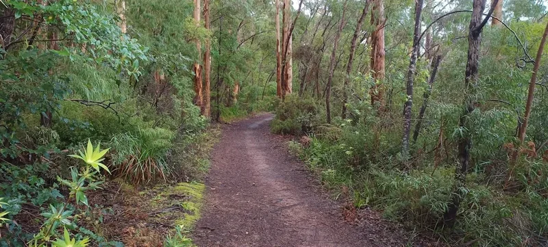
The Mount Warning summit track is a strenuous but highly rewarding day walk that ascends to the rim of an ancient shield volcano. Standing at 1,159 metres above sea level, the summit provides unparalleled 360-degree views that stretch across the caldera, the surrounding rainforests, and out to the Gold Coast and Byron Bay on clear days. The trail itself is a testament to the volcanic forces that created this landscape, winding through dense, subtropical rainforest that is teeming with life. The ascent is characterised by a series of steep, man-made steps and natural inclines, making it a significant physical challenge. The journey begins at the base of the volcano, gradually climbing through a diverse ecosystem where towering ancient trees, vibrant ferns, and an array of birdlife create an immersive natural experience. The air is often thick with humidity, and the sounds of the rainforest accompany every step. As you gain altitude, the vegetation changes, and glimpses of the surrounding landscape begin to appear through the canopy. The final push to the summit involves navigating a steep, rocky section with chains to assist climbers, adding an element of adventure to the trek. Reaching the summit is a triumphant moment, offering a profound sense of accomplishment and a spectacular reward for the effort expended. The sunrise from Mount Warning is particularly famous, with the first rays of light illuminating the caldera and the vast expanse of the Pacific Ocean.
The geological history of Mount Warning is fascinating. It is the remnant of an enormous shield volcano that erupted millions of years ago. The caldera, the vast circular depression formed by volcanic activity, is now a lush, fertile basin that supports a unique and diverse ecosystem. The surrounding mountains are the eroded remnants of the volcano's outer slopes. The Bundjalung people, the traditional custodians of this land, hold Wollumbin in deep spiritual reverence, considering it a sacred site and a place of great cultural importance. The name "Wollumbin" is believed to mean "cloud catcher" or "great cloud," reflecting its imposing presence and its tendency to be shrouded in mist. The trail is managed by the National Parks and Wildlife Service, with a focus on preserving the natural environment and respecting the cultural significance of the site.
The challenging nature of the hike means it is best suited for individuals with a good level of fitness and prior hiking experience. The steep gradients, uneven terrain, and the sheer distance require stamina and resilience. However, for those prepared to meet the challenge, the experience of walking through this ancient rainforest and reaching the summit is an unparalleled adventure in one of Australia's most beautiful natural settings.
History and Cultural Context
Mount Warning (Wollumbin) holds immense cultural and spiritual significance for the Bundjalung people, the traditional custodians of the land for tens of thousands of years. For them, Wollumbin is not just a mountain; it is a sacred site, a place of creation, and a powerful ancestral being. According to Bundjalung Dreaming stories, Wollumbin was formed when the spirit of a warrior, who had been killed in battle, rose from the earth to become the mountain. It is a place where ceremonies were performed, and where important decisions were made. The Bundjalung people have a deep and enduring connection to Wollumbin, and their traditional knowledge of the land, its resources, and its spiritual essence is invaluable. The mountain is considered a sacred place, and access to certain areas has historically been restricted to protect its spiritual integrity. Visitors are urged to approach Wollumbin with respect for its cultural heritage and to be mindful of its sacred status.
The geological history of Mount Warning is equally compelling. It is the eroded remnant of a massive shield volcano that formed approximately 23 million years ago. The volcano was part of the Tweed Volcano, one of the largest shield volcanoes in Australia. Over millions of years, erosion has sculpted the landscape, leaving behind the distinctive caldera and the prominent peak of Wollumbin. The rich volcanic soils have fostered the development of the incredibly diverse subtropical rainforest that cloaks the mountain's slopes, a testament to the enduring power of geological processes. The area was first explored by Europeans in the late 18th century, with Captain James Cook sighting the peak in 1770 and naming it "Mount Warning" because it served as a navigational hazard for ships approaching the coast. European settlement in the region began in the 19th century, with the fertile volcanic soils attracting farmers and loggers. Despite the impact of European settlement, the natural beauty and cultural significance of Mount Warning were eventually recognised, leading to its protection as a national park.
The establishment of Wollumbin National Park in the late 20th century aimed to preserve the unique rainforest ecosystem and protect the cultural heritage of the Bundjalung people. The park is a vital sanctuary for a wide array of flora and fauna, many of which are endemic to the region. The trail to the summit, while popular with hikers, is carefully managed to minimise its impact on the environment and to respect the sacred nature of the mountain. The ongoing dialogue between the National Parks and Wildlife Service and the Bundjalung community is crucial in ensuring the long-term protection and respectful management of Wollumbin.
Seasonal Highlights and Weather Reality
The best time to tackle the Mount Warning summit trail is during the cooler, drier months of autumn and spring. From March to May (autumn) and September to November (spring), the weather is generally more pleasant, with milder temperatures and less humidity, making the strenuous climb more comfortable. These seasons also offer lower rainfall, increasing the chances of clear skies and spectacular summit views. The rainforest is particularly vibrant during these periods, with lush greenery and a rich array of birdlife.
Summer (December to February) in this region can be very hot and humid, with high rainfall and the potential for thunderstorms. While the rainforest offers shade, the humidity can make the climb feel significantly more challenging, and the risk of heat exhaustion is higher. Summer is also the peak season for insects, including mosquitoes and sandflies, which can be a nuisance on the trail. However, after heavy summer rains, the waterfalls and streams within the rainforest are at their most impressive, and the vegetation is at its most verdant.
Winter (June to August) offers cooler temperatures and lower humidity, which can be ideal for hiking. However, winter can also bring increased rainfall and fog, particularly at higher elevations. The summit can be frequently shrouded in cloud, obscuring the panoramic views. While the cooler temperatures reduce the risk of heatstroke, it is still essential to dress in layers, as the temperature can drop significantly at the summit, especially in the early morning or late afternoon.
Regardless of the season, it is crucial to be prepared for the unpredictable nature of mountain weather. Conditions can change rapidly, with fog, rain, and strong winds appearing with little warning. Always check the weather forecast before you go and be prepared for all eventualities. The rainforest environment means the track can become slippery and hazardous after rain, so sturdy footwear is essential year-round.
Recommended Itinerary
Mount Warning (Wollumbin) Summit Day Walk
Early Morning (Pre-dawn): Departure from Murwillumbah/Accommodation
- Depart from your accommodation in Murwillumbah or a nearby town.
- Allow approximately 20-30 minutes driving time to the trailhead.
- Ensure you have had a light breakfast and are well-hydrated.
- Check the weather forecast one last time.
Morning (Sunrise - 5:00 AM - 7:00 AM): Trailhead Arrival and Ascent Commencement
- Arrive at the Mount Warning National Park trailhead.
- Register your visit at the trailhead logbook (mandatory).
- Begin the ascent as the first light begins to break. This timing is ideal for experiencing the sunrise from the summit.
- The initial section of the track is a well-maintained path through dense subtropical rainforest.
- Distance: 0 km - 2 km
- Elevation Gain: ~200 m
- Time: 45-60 minutes
Mid-Morning (7:00 AM - 9:00 AM): Rainforest Immersion and Gradual Climb
- Continue ascending through the heart of the ancient rainforest.
- Observe the diverse flora and fauna: towering ancient trees, epiphytic ferns, moss-covered branches, and a symphony of bird calls.
- The track becomes steeper, with sections of stairs and natural inclines.
- Take short breaks to hydrate and appreciate the surroundings.
- Distance: 2 km - 5 km
- Elevation Gain: ~500 m
- Time: 1.5 - 2 hours
Late Morning (9:00 AM - 11:00 AM): The Steep Ascent and Summit Push
- The gradient intensifies significantly.
- You will encounter the most challenging sections of the hike, including steep staircases and rocky outcrops.
- Chains are installed to assist with the final, most demanding ascent to the summit.
- Maintain a steady pace, focus on your footing, and use the chains for support.
- Distance: 5 km - 7.5 km
- Elevation Gain: ~400 m
- Time: 1.5 - 2 hours
Midday (11:00 AM - 1:00 PM): Summit Experience and Panoramic Views
- Reach the summit of Mount Warning (Wollumbin).
- Spend time absorbing the spectacular 360-degree views.
- Identify landmarks: the caldera, surrounding rainforest, the Pacific Ocean, Gold Coast skyline, Byron Bay.
- Enjoy a well-deserved rest and a packed lunch.
- Take photographs and reflect on the achievement.
- Distance: 7.5 km - 8.8 km (summit area)
- Elevation Gain: ~59 m (final summit plateau)
- Time: 1 - 2 hours (at summit)
Afternoon (1:00 PM onwards): Descent and Return to Trailhead
- Begin the descent. Take care on the steep sections, especially the stairs and rocky parts.
- The descent can be as challenging as the ascent for your knees and balance.
- Continue through the rainforest, enjoying the different perspective on the way down.
- Return to the trailhead.
- Distance: 8.8 km - 0 km
- Elevation Loss: 1159 m
- Time: 2 - 3 hours
Post-Hike:
- Sign out at the trailhead logbook.
- Consider a celebratory meal or refreshment in Murwillumbah.
- Allow ample time for travel back to your accommodation.
Important Notes:
- This is a challenging hike requiring good fitness.
- Start early, especially if aiming for sunrise.
- Carry plenty of water (at least 2-3 litres per person).
- Wear sturdy, closed-in walking shoes with good grip.
- Bring insect repellent and sun protection (hat, sunscreen).
- Be prepared for rapidly changing weather conditions.
- Respect the cultural significance of Wollumbin.
- The summit track may be closed due to weather or cultural reasons; always check NPWS alerts.
Planning and Bookings
Book Your Trip
Everything you need to plan your journey
Accommodation
Find places to stay near Murwillumbah
Flights
Search flights to Murwillumbah
Essential Preparation
Mount Warning (Wollumbin) is a popular day hike, and while no advance bookings are required for the trail itself, proper preparation is paramount for a safe and enjoyable experience. The closest town with comprehensive services is Murwillumbah, located about 20-30 minutes' drive from the trailhead. Murwillumbah offers a range of accommodation options, from motels and bed and breakfasts to caravan parks. It also has supermarkets for stocking up on supplies, outdoor gear shops, and numerous cafes and restaurants. Gold Coast Airport (OOL) is the nearest major airport, approximately a 1-hour 15-minute drive away. Visitors arriving by air will need to arrange car hire or private transport to reach the Murwillumbah area and then the trailhead. The road to the trailhead is sealed and accessible by standard vehicles. It is essential to check the NSW National Parks and Wildlife Service (NPWS) website for any track closures or alerts before your visit, as the track can be closed due to weather conditions (heavy rain, fog, or lightning) or for cultural reasons. A good level of physical fitness is required due to the steep and demanding nature of the climb.
Trail Accommodation
This is a day hike requiring no overnight accommodation.
Required Gear
- Sturdy Hiking Boots: Waterproof and with excellent ankle support and grip are essential for the steep, uneven, and potentially slippery terrain.
- Backpack: A comfortable daypack (20-30 litres) to carry essentials.
- Navigation: While the track is well-marked, a map or GPS device with the trail downloaded is advisable, especially for understanding your progress and elevation.
- First Aid Kit: Comprehensive kit including blister treatment, bandages, antiseptic wipes, pain relievers, and any personal medications.
- Head Torch/Headlamp: Crucial if you plan to hike for sunrise or sunset, or in case of unexpected delays. Ensure it has fresh batteries.
- Rain Gear: A waterproof and windproof jacket is essential, as weather can change rapidly.
- Sun Protection: Wide-brimmed hat, sunglasses, and high SPF sunscreen. Even on cloudy days, the sun can be intense at the summit.
- Insect Repellent: Especially important during warmer months to ward off mosquitoes and sandflies.
What to Bring
- Water: Carry a minimum of 2-3 litres of water per person. There are no water sources available on the track.
- Food: High-energy snacks and a packed lunch. You will be exerting a lot of energy, so bring plenty of food to keep you fuelled. Examples include trail mix, energy bars, fruit, sandwiches.
- Toiletries: Hand sanitiser, tissues, and any personal hygiene items. Pack out all rubbish.
- Mobile Phone: Fully charged, for emergencies. Signal can be intermittent.
- Camera: To capture the stunning views.
- Walking Poles (Optional): Can be beneficial for reducing strain on knees during the steep ascent and descent.
- Small Towel: Useful if you get caught in rain or for wiping sweat.
Permits

No specific permits are required to hike the Mount Warning (Wollumbin) summit trail. However, it is mandatory for all visitors to register their visit at the trailhead logbook. This is a crucial safety measure that allows authorities to track who is on the mountain in case of an emergency. The logbook is typically located at the start of the trail, near the car park.
While no fees are charged for accessing the national park or using the trail, visitors are encouraged to consider making a donation to support the conservation efforts of the NSW National Parks and Wildlife Service. These donations help maintain the trails, protect the environment, and preserve the cultural heritage of sites like Wollumbin.
It is essential to check the NSW National Parks and Wildlife Service (NPWS) website for any alerts or closures before your visit. The track can be temporarily closed due to adverse weather conditions, such as heavy rain, fog, or lightning, which can make the summit treacherous. Closures can also occur for cultural reasons, to allow the Bundjalung people to conduct ceremonies or manage the site according to their traditions. Respecting these closures is vital for both safety and cultural preservation.
Other Activities in the Area
The region surrounding Mount Warning (Wollumbin) offers a wealth of activities for visitors looking to extend their stay and explore the diverse attractions of the Tweed Valley and Northern Rivers region:
- Explore Murwillumbah: This charming town is the gateway to Mount Warning and boasts a vibrant arts scene, excellent cafes, local galleries, and the Tweed Regional Museum, which provides insights into the area's history and culture.
- Visit Tweed Regional Gallery & Margaret Olley Art Centre: Located just outside Murwillumbah, this award-winning gallery showcases a significant collection of Australian art, including a dedicated centre celebrating the life and work of artist Margaret Olley.
- Discover the Tweed Valley Hinterland: Drive through the scenic countryside, visit local farms, sample regional produce, and explore charming villages like Uki, known for its pottery and artisan crafts.
- Explore other National Parks: The region is dotted with other beautiful national parks offering various walking tracks and natural wonders. Consider visiting Nightcap National Park for its stunning waterfalls like Minyon Falls, or Border Ranges National Park for its ancient rainforests and scenic lookouts.
- Coastal Exploration: The beautiful beaches of the Tweed Coast, including Kingscliff, Cabarita Beach, and Pottsville, are within easy driving distance, offering opportunities for swimming, surfing, and relaxing by the ocean.
- Whale Watching (Seasonal): During the winter months (June to November), the waters off the Tweed Coast are a popular migration route for humpback whales. Numerous boat tours depart from local harbours for an unforgettable whale-watching experience.
- Kayaking and Water Sports: The Tweed River and its tributaries offer opportunities for kayaking, canoeing, and paddleboarding, providing a different perspective of the lush hinterland.
Safety and Conditions
Trail Conditions: The Mount Warning summit track is a challenging hike. The majority of the ascent involves steep, uneven terrain, including numerous stairs and rocky sections. The track can become very slippery and hazardous after rain, especially the granite steps and rock faces near the summit. Always wear appropriate footwear with good grip.
Weather: Mountain weather is notoriously unpredictable. Conditions can change rapidly, with fog, heavy rain, and strong winds appearing with little notice, even on seemingly clear days. The summit can be significantly cooler and windier than the base. Always check the weather forecast before you depart and be prepared for all conditions. If thunderstorms are forecast, do not attempt the hike, as the summit is exposed and lightning poses a severe risk.
Physical Fitness: This hike requires a good level of cardiovascular fitness and leg strength. The 1159-metre elevation gain over 8.8 km is strenuous. If you are not accustomed to steep climbs, consider starting with shorter, less demanding walks. Pace yourself, take regular breaks, and listen to your body.
Water and Food: Carry ample water (at least 2-3 litres per person) as there are no water sources on the trail. Dehydration can occur quickly, especially in warm weather. Bring high-energy snacks and a packed lunch to maintain your energy levels throughout the hike.
Insect Protection: Mosquitoes and sandflies can be prevalent, particularly during warmer months and in damp conditions. Use effective insect repellent and consider wearing long sleeves and trousers to minimise exposed skin.
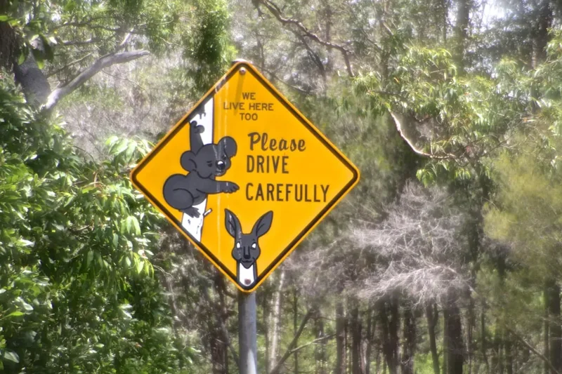
Cultural Sensitivity: Wollumbin is a sacred site for the Bundjalung people. Visitors must show respect for its cultural significance. Stay on marked trails, do not disturb any cultural artefacts or sites, and be mindful of any closures or restrictions that may be in place.
Emergency Procedures: Inform someone of your hiking plans, including your expected return time. Carry a fully charged mobile phone, although reception can be intermittent. In case of emergency, call Triple Zero (000) or the NPWS emergency line if provided. The trailhead logbook is essential for tracking visitors.
Summit Chains: The final ascent to the summit involves steep rock faces with chains for assistance. Use these chains carefully and ensure you have a secure handhold and foothold before moving. If you are uncomfortable with heights or exposed sections, it may be advisable to turn back before reaching the summit.
Side Trips and Points of Interest
The Summit Viewpoint: The primary "point of interest" is, of course, the summit itself. Upon reaching the top, you are rewarded with an unparalleled 360-degree panorama. On a clear day, the views are truly spectacular, encompassing the vast circular caldera of the ancient volcano, the dense subtropical rainforest stretching out below, the rolling hills of the Tweed Valley, and the distant coastline of the Pacific Ocean, including the Gold Coast and Byron Bay. The sunrise from this vantage point is particularly famous, painting the sky and landscape in breathtaking colours.
The Rainforest Ecosystem: The entire trail is a journey through a magnificent example of subtropical rainforest. As you ascend, observe the incredible biodiversity: ancient fig trees with buttress roots, towering flooded gums, vibrant ferns, mosses, lichens, and an abundance of epiphytic plants. Keep an eye and ear out for the diverse birdlife, including parrots, lorikeets, and various rainforest species. The sounds and smells of the rainforest create an immersive and sensory experience.
The Caldera Rim: Walking along the rim of the ancient volcano provides a unique perspective on its geological formation. You can clearly see the vast depression that was once the heart of the volcano, now a fertile basin supporting a rich ecosystem. The sheer scale of the volcanic activity that created this landscape is awe-inspiring.
The Chains Section: While a challenging part of the hike, the section near the summit where chains are installed to aid climbers is a notable feature. It adds an element of adventure and requires careful navigation and physical effort, making the final push to the summit a memorable part of the experience.
The Trailhead Logbook: While not a natural point of interest, the logbook at the trailhead is a significant feature for safety and tracking. It serves as a reminder of the importance of responsible hiking and the shared experience of visitors to this special place.
Leave No Trace
Mount Warning (Wollumbin) is a place of immense natural beauty and profound cultural significance. To ensure its preservation for future generations and to honour its sacred status, it is imperative that all visitors adhere to Leave No Trace principles:
- Plan Ahead and Prepare: Research the trail, check weather forecasts, and understand any closures or alerts. Know the physical demands of the hike and be prepared.
- Travel and Camp on Durable Surfaces: Stay on the marked track at all times. The rainforest ecosystem is fragile, and straying from the path can cause erosion and damage delicate vegetation. The summit area is also a designated durable surface.
- Dispose of Waste Properly: Pack out everything you pack in. This includes all food scraps, wrappers, tissues, and any other rubbish. There are no bins on the trail or at the summit. Use the toilet facilities at the trailhead if available, or be prepared to carry out human waste if necessary (though this is generally not required for day hikes with proper planning).
- Leave What You Find: Do not take any natural souvenirs, such as rocks, plants, or flowers. Leave the mountain as you found it for others to enjoy.
- Minimise Campfire Impacts: Campfires are not permitted on this day hike.
- Respect Wildlife: Observe animals from a distance and never feed them. Feeding wildlife can disrupt their natural behaviours and diets, and can be harmful to their health.
- Be Considerate of Other Visitors: Keep noise levels down, especially near the summit, to allow everyone to appreciate the natural environment and the spiritual atmosphere of Wollumbin. Yield to uphill walkers.
Furthermore, as Wollumbin is a sacred site for the Bundjalung people, visitors must approach the mountain with reverence and respect. Understand its cultural importance, adhere to any specific guidelines provided by the National Parks and Wildlife Service, and be mindful of the spiritual significance of the place. Tread lightly, walk respectfully, and leave only footprints.