Mount Tronador Ascent
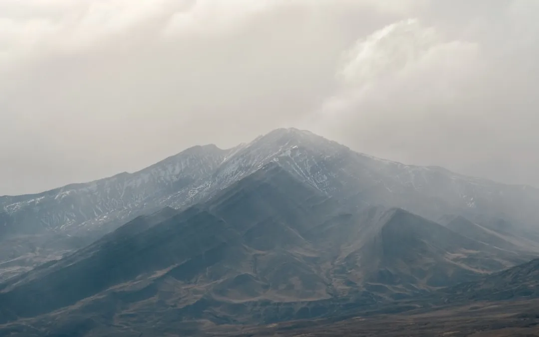
The Mount Tronador Ascent is a formidable mountaineering challenge located in the heart of the Patagonian Andes, straddling the border between Argentina and Chile. This multi-day expedition is not a marked trail in the conventional sense but rather a route requiring advanced alpine skills, glacier travel experience, and a high degree of physical and mental fortitude. Ascending Mount Tronador, whose name translates to "Thunderer" due to the frequent avalanches and icefalls that echo through the valleys, offers unparalleled views of the surrounding glacial landscapes, including the vast Southern Patagonian Ice Field. The ascent typically involves navigating challenging terrain, including scree slopes, ice fields, and potentially crevassed glaciers, culminating in a summit push that demands technical proficiency.
- Distance: Approximately 25.0 km (round trip from Pampa Linda)
- Elevation Gain: Approximately 2,800 m
- Duration: 2-3 days
- Difficulty: Very Challenging / Expert
- Best Time: December to March (Patagonian summer)
- Closest City: San Carlos de Bariloche, Argentina
- Trailhead Access: Via Pampa Linda, accessible from Bariloche
- Permits: Required for Nahuel Huapi National Park
Overview
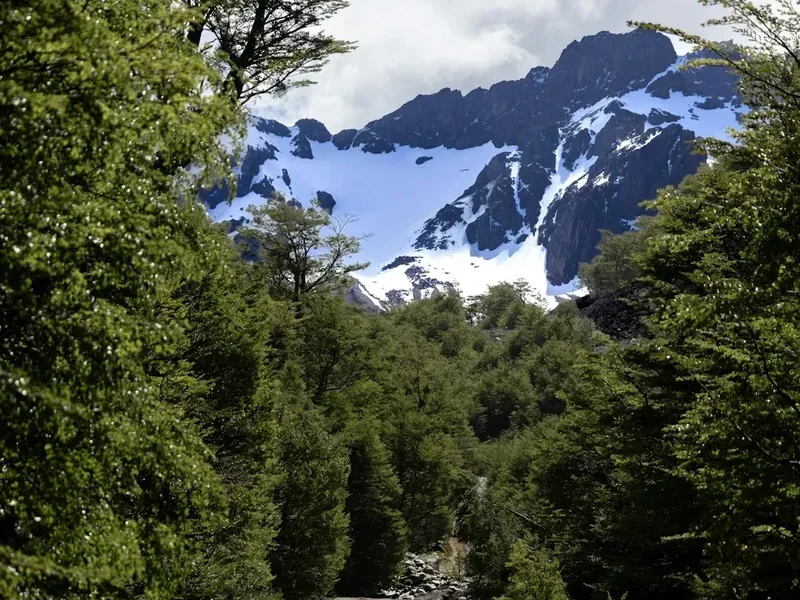
Mount Tronador (3,470 m) is an iconic stratovolcano and the highest peak in the region surrounding San Carlos de Bariloche. Its imposing presence, crowned by three distinct summits—International, Main, and White—makes it a magnet for experienced mountaineers. The ascent is a serious undertaking, typically requiring at least two full days of strenuous climbing and glacier travel, often extending to three days depending on weather conditions and the team's pace. The route begins from Pampa Linda, a picturesque valley accessible by a scenic but sometimes challenging road from Bariloche. From Pampa Linda, the approach involves hiking through forests and alpine meadows before reaching the glacial environment.
The journey is characterised by its dramatic elevation gain and the transition from lush Patagonian forests to stark, icy alpine terrain. Climbers must be prepared for rapidly changing weather, including strong winds, snow, and freezing temperatures, even during the summer months. The ascent often involves crossing the Alerce Glacier and potentially the Castaño Overo Glacier, depending on the chosen route and conditions. Technical climbing gear, including crampons, ice axes, ropes, and potentially ice screws, is essential. The summit offers a breathtaking panorama of the Southern Patagonian Ice Field, numerous glacial lakes, and the surrounding Andean peaks, a reward for the immense effort involved.
This is not a trek for the casual hiker. It demands a high level of fitness, prior experience in alpine environments, and the ability to navigate and manage risks associated with glacier travel and high-altitude mountaineering. Guided expeditions are highly recommended for those without extensive experience in such conditions.
History and Cultural Context
Mount Tronador has a long history of human interaction, though its formidable nature meant that sustained habitation or regular passage was limited. Indigenous peoples, including the Mapuche and Tehuelche, likely traversed the broader region for millennia, utilising the valleys for hunting and gathering. The name "Tronador" itself is attributed to the sound of avalanches and icefalls, a phenomenon that would have been a constant presence and a source of awe and respect for any who ventured near the mountain.
European exploration of the region intensified in the late 19th and early 20th centuries. Francisco Pascasio Moreno, an Argentine explorer and scientist, played a significant role in mapping and documenting the area. The peak was first summited in 1934 by a team led by Otto Meiling, a German-Argentine mountaineer who was instrumental in establishing mountaineering in the Bariloche region. Meiling's ascent marked a significant achievement in Patagonian mountaineering history and opened the door for future expeditions.
The area surrounding Mount Tronador is part of Nahuel Huapi National Park, established in 1934, making it one of Argentina's oldest national parks. The park's creation aimed to protect the unique ecosystems, glacial landscapes, and indigenous heritage of the region. Today, Mount Tronador remains a symbol of the wild, untamed beauty of Patagonia and a premier destination for serious mountaineers seeking a challenging and rewarding alpine adventure.
Seasonal Highlights and Weather Reality
The optimal season for ascending Mount Tronador is during the Patagonian summer, which runs from December to March. During these months, daylight hours are longer, and the weather is generally more stable, although still highly unpredictable.
Summer (December to March): This period offers the best chance for favourable weather conditions. Temperatures at higher elevations can still be below freezing, especially at night and on the glaciers. Snowfall is possible at any time, and strong winds are a frequent occurrence. Avalanches and icefalls are common, contributing to the mountain's name. The glaciers are generally more accessible, with less snow cover, but crevasses can still be hidden. This is the only period when guided expeditions are regularly undertaken.
Shoulder Seasons (November and April): These months can offer a mixed bag. November might still have significant snowpack, making glacier travel more challenging and potentially dangerous. April sees temperatures dropping rapidly, and the risk of early winter storms increases. While possible for highly experienced and self-sufficient climbers, these months are generally less recommended due to increased risk and reduced daylight.
Winter (May to October): Mount Tronador is effectively inaccessible for climbing during the winter months due to heavy snowfall, extreme cold, and dangerous avalanche conditions. The access road to Pampa Linda may also be closed or impassable.
Weather Reality: It cannot be overstated that weather in the Andes is notoriously fickle. Even in summer, climbers must be prepared for sudden storms, whiteouts, and extreme temperature drops. Flexibility in the itinerary is crucial, as summit attempts may need to be postponed or cancelled due to adverse conditions.
Recommended Itinerary
2-3 Day Mount Tronador Ascent Itinerary
Day 1: Bariloche to Pampa Linda and Refugio Frey (or similar base camp)
- Distance: Approximately 10-12 km (hiking from Pampa Linda)
- Elevation Gain: Approximately 800-1000 m
- Time: 5-7 hours
- Morning: Travel from San Carlos de Bariloche to Pampa Linda (approx. 2 hours by road). Ensure vehicle is suitable for potential gravel/rough sections.
- Late Morning: Begin hike from Pampa Linda towards the base of Mount Tronador. The initial section passes through forests and open meadows.
- Afternoon: Arrive at a designated camping area or a basic mountain refuge (e.g., Refugio Frey, though this is a significant detour and a closer camp is more typical for Tronador). Establish camp or settle into the refuge.
- Evening: Prepare gear for the next day's ascent, acclimatise to the altitude, and rest.
- Key Waypoints: Pampa Linda, various stream crossings, transition from forest to alpine terrain.
Day 2: Ascent to the Glacier and Summit Push
- Distance: Approximately 8-10 km (one way to summit)
- Elevation Gain: Approximately 1800-2000 m
- Time: 8-12 hours (round trip to summit and back to base camp)
- Very Early Morning: Depart from base camp before dawn to maximise daylight and favourable conditions.
- Morning: Approach and ascend the Alerce Glacier or Castaño Overo Glacier. This involves glacier travel, requiring crampons, ice axe, and roped travel if conditions warrant. Navigate crevasses carefully.
- Midday: Reach the higher slopes of Tronador. The final push to the summit may involve steep snow or ice climbing, depending on the route and conditions.
- Afternoon: Summit Mount Tronador (3,470 m). Enjoy panoramic views (weather permitting).
- Late Afternoon/Evening: Descend carefully back to the base camp. This descent is often as challenging as the ascent.
- Key Waypoints: Glacier approach, crevasse fields, summit ridge, various peaks of Tronador.
Day 3: Descent and Return to Bariloche (Contingency Day)
- Distance: Approximately 10-12 km (hiking back to Pampa Linda)
- Elevation Loss: Approximately 800-1000 m
- Time: 4-6 hours
- Morning: Pack up camp and begin the descent from the base camp back to Pampa Linda.
- Afternoon: Arrive at Pampa Linda, where transport awaits to return to San Carlos de Bariloche.
- Contingency: This day is often used as a buffer for weather delays on Day 2, allowing for a summit attempt on Day 3 if Day 2 was unsuccessful due to conditions. If the summit was reached on Day 2, this day is purely for descent and return.
- Key Waypoints: Pampa Linda, return trail through forests and meadows.
Important Notes:
- This itinerary is a guideline; actual timings and routes will vary based on weather, snow conditions, and the specific expedition plan.
- Guided expeditions are highly recommended for this ascent.
- All necessary mountaineering equipment is mandatory.
- Carry sufficient food and water for the entire duration.
- Be prepared for extreme weather changes at any time.
Planning and Bookings
Book Your Trip
Everything you need to plan your journey
Accommodation
Find places to stay near San Carlos de Bariloche
Flights
Search flights to San Carlos de Bariloche
Essential Preparation
Ascending Mount Tronador is a serious mountaineering endeavour that requires meticulous planning and preparation. The closest major city and logistical hub is San Carlos de Bariloche, which offers all necessary services, including gear rental, experienced guides, and transport options. It is crucial to book any guided expeditions well in advance, as reputable guides have limited availability, especially during the peak summer season (December to March).
Physical fitness is paramount. Climbers should be in excellent cardiovascular condition and have experience with multi-day hikes carrying a heavy pack. Prior experience with glacier travel, crevasse rescue, and basic ice climbing techniques is highly beneficial, if not essential, especially if not undertaking a guided trip. Familiarity with navigation in alpine environments and the ability to use ice axes and crampons are non-negotiable skills.
Logistics include arranging transport to Pampa Linda. While some private vehicles can manage the road, a 4x4 or a vehicle with good ground clearance is advisable. Alternatively, local tour operators in Bariloche can arrange transport. Accommodation in Bariloche before and after the climb is readily available, ranging from hostels to hotels.
Trail Accommodation
This is a mountaineering route, not a traditional hiking track with established huts. Accommodation is primarily camping or basic mountain refuges.
Camping: Designated camping areas exist near Pampa Linda and at various points along the approach to the glaciers. These are typically undeveloped sites requiring self-sufficiency. Campers must carry all their gear, including tents, sleeping bags, and cooking equipment.
Mountain Refuges: Basic refuges or bivouac shelters may be available at certain points, such as near the base of the glaciers. These are often rudimentary, offering shelter from the elements but little in terms of amenities. Availability can be limited, and they are not bookable in the same way as DOC huts. It is best to assume you will be camping.
Booking Requirements: For camping, no specific booking is usually required for the undeveloped sites, but it is advisable to check with the Nahuel Huapi National Park administration in Bariloche for any local regulations or recommendations. If using a guided service, accommodation arrangements will be part of the package.
Facilities Provided: Generally, no facilities are provided at camping or basic refuge locations. You must be entirely self-sufficient.
What's NOT Provided: All camping and mountaineering gear, food, water treatment, cooking equipment, and waste disposal are the responsibility of the climber.
Seasonal Availability: Camping and basic shelters are available year-round, but only accessible and safe during the summer months (December to March) for climbing purposes.
Costs: Camping fees, if applicable, are minimal. Guided expeditions will have significant costs covering guides, permits, and potentially shared equipment.
Required Gear
- Mountaineering boots: Stiff, insulated, waterproof boots suitable for crampon use.
- Crampons: Steel crampons with anti-balling plates, compatible with your boots.
- Ice axe: General mountaineering ice axe.
- Helmet: Essential for protection against falling ice and rock.
- Harness: Climbing harness for glacier travel and potential rope work.
- Rope: Dynamic climbing rope (e.g., 50-60m), if travelling in a roped team.
- Carabiners and belay device: For rope management and safety.
- Trekking poles: With snow baskets for stability on varied terrain.
- Waterproof and windproof outer shell jacket and trousers: Gore-Tex or equivalent, with taped seams.
- Insulated jacket: Down or synthetic fill for warmth.
- Warm layers: Merino wool or synthetic base layers, fleece mid-layers.
- Gloves: Multiple pairs – liner gloves, warm insulated gloves, and waterproof over-mitts.
- Hat: Warm beanie that covers the ears.
- Gaiters: To prevent snow and debris from entering boots.
- Head torch: With spare batteries, essential for early starts and potential night descents.
- First aid kit: Comprehensive kit including blister treatment, pain relief, and personal medications.
- Navigation tools: GPS device or smartphone with offline maps, compass, and map.
- Sun protection: High SPF sunscreen, lip balm, sunglasses (glacier glasses recommended), and a wide-brimmed hat.
- Backpack: 60-75 litre capacity, robust and comfortable for carrying heavy loads.
- Tent: 4-season tent suitable for alpine conditions.
- Sleeping bag: Rated to at least -10°C comfort.
- Sleeping pad: Insulated pad for warmth and comfort.
What to Bring
- Food: High-energy, lightweight food for 2-3 days (e.g., dehydrated meals, energy bars, nuts, dried fruit, chocolate). Plan for more than you think you'll need.
- Water bottles/hydration reservoir: At least 2-3 litres capacity.
- Water treatment: Filter or purification tablets (stream water is available but should be treated).
- Toiletries: Biodegradable soap, toothbrush, toothpaste, toilet paper, hand sanitiser.
- Personal items: Camera, power bank for electronics, book or journal.
- Duct tape and repair kit: For gear repairs.
- Emergency shelter: Lightweight emergency bivvy bag.
- Personal Locator Beacon (PLB) or satellite messenger: Highly recommended for remote areas.
- Cash: For any potential fees or purchases in Bariloche or Pampa Linda.
Permits
Entry into Nahuel Huapi National Park requires a permit. While specific permits for the Mount Tronador ascent itself are not typically issued in the same way as for multi-day treks with designated campsites, visitors must pay the park entrance fee. This fee can usually be purchased at the park entrance stations or in advance from the National Parks Administration offices in San Carlos de Bariloche.
Park Entrance Fees:
- Fees are subject to change and are typically paid per person, per day.
- It is advisable to check the official Nahuel Huapi National Park website or contact their office in Bariloche for the most current fee structure and payment methods.
- Prices can vary for Argentinian residents and foreign visitors.
Guided Expeditions: If you are undertaking a guided expedition, the tour operator will usually handle all necessary park permits and fees as part of their service. Confirm this when booking.
Camping Regulations: While specific campsites may not require booking, it is essential to adhere to park regulations regarding camping. This includes camping only in designated areas (if any exist) or in a manner that minimises environmental impact. Campfires are often prohibited in national parks; use a stove for cooking.
Information Sources:
- Nahuel Huapi National Park Administration (Administración de Parques Nacionales - APN) in Bariloche.
- Official websites of the APN for updated permit and fee information.
Other Activities in the Area
The region around San Carlos de Bariloche and Nahuel Huapi National Park offers a wealth of activities for those who enjoy the outdoors:
- Cerro Catedral Ski Resort: In winter, this is a premier ski destination. In summer, it offers hiking and scenic chairlift rides.
- Hiking in Nahuel Huapi National Park: Numerous trails cater to various fitness levels, from short walks to multi-day treks. Popular options include the trail to Refugio Frey, Refugio Otto Meiling, and the Arrayanes Forest.
- Kayaking and Boating on Nahuel Huapi Lake: Explore the vast lake, visit islands like Victoria Island, or enjoy watersports.
- Scenic Drives: The Circuito Chico is a famous scenic route offering stunning viewpoints and access to various attractions.
- Bariloche City: Explore the charming alpine-style town, known for its chocolate shops, breweries, and restaurants.
- Cerro Llao Llao: A beautiful area with walking trails offering spectacular views of the lake and surrounding mountains.
- El Bolsón: A bohemian town south of Bariloche, known for its artisan markets and relaxed atmosphere.
- Patagonian Cuisine: Sample local specialities like lamb asado, trout, and artisanal chocolates.
Safety and Conditions
Pre-Departure Checks:
- Weather Forecasts: Obtain the most up-to-date mountain weather forecasts for the Tronador region. Websites like MeteoRed or local meteorological services in Bariloche are essential resources. Be aware that forecasts can change rapidly.
- Park Conditions: Contact the Nahuel Huapi National Park administration in Bariloche for any specific alerts, trail closures, or conditions related to the access road to Pampa Linda or the approach routes to Tronador.
- Avalanche Risk: During the climbing season, especially early or late in summer, be aware of avalanche risks. Consult local guides or park rangers for current conditions.
- Route Conditions: If possible, speak with recent climbers or guides about current snow and ice conditions on the glaciers and summit routes.
Alpine Hazards:
- Rapid Weather Changes: The Andes are notorious for sudden shifts in weather. Be prepared for strong winds, heavy snowfall, rain, fog, and significant temperature drops, even in summer.
- Crevasses: The glaciers on Mount Tronador are glaciated and contain crevasses, some of which may be hidden by snow bridges. Roped travel and proper crevasse rescue techniques are essential.
- Altitude Sickness: The ascent to 3,470 metres can induce altitude sickness. Acclimatise properly by spending time at altitude before the climb and ascend gradually. Be aware of symptoms (headache, nausea, dizziness) and descend if they worsen.
- Falls: Steep, icy, or scree-covered slopes pose a risk of falls. Proper use of ice axe and crampons, along with careful footwork, is critical.
- Hypothermia: Cold temperatures, wind, and wet conditions can lead to hypothermia. Wear appropriate layers, stay dry, and eat regularly to maintain body heat.
Travel Insurance: Ensure your travel insurance covers high-altitude mountaineering and potential emergency evacuation. This is crucial for a trip of this nature.
Communication: Mobile phone reception is non-existent on the mountain. Consider carrying a Personal Locator Beacon (PLB) or satellite messenger for emergencies.
Side Trips and Points of Interest
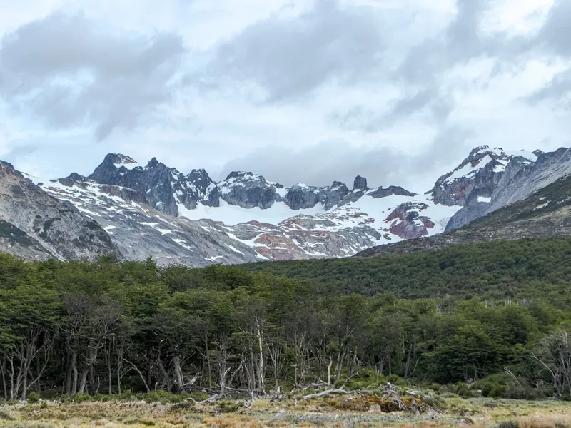
Ventisquero Alerces (Alerce Glacier): This is one of the primary glaciers encountered on the ascent of Mount Tronador. Its vast expanse of ice, with its characteristic blue hues and dramatic icefalls, is a significant feature of the climb. Observing the glacier's movement and the forces of nature at play is a key part of the experience.
Ventisquero Castaño Overo (Castaño Overo Glacier): Depending on the chosen route, climbers may also traverse or approach the Castaño Overo Glacier. This glacier offers different perspectives and challenges, often involving more technical ice travel.
The Three Summits: Mount Tronador is comprised of three distinct peaks: International Summit (3,470 m), Main Summit (3,410 m), and White Summit (3,250 m). The ascent typically targets the highest, the International Summit. The sheer scale and separation of these peaks are impressive from any vantage point.
Views of the Southern Patagonian Ice Field: On a clear day from the summit or higher slopes, climbers can gain breathtaking views of the immense Southern Patagonian Ice Field, the world's third-largest ice body outside the polar regions. This vast expanse of ice stretching towards the horizon is a humbling sight.
Glacial Lakes and Waterfalls: The approach to Tronador passes through areas with stunning glacial lakes and numerous waterfalls fed by melting ice and snow. These provide beautiful photographic opportunities and a sense of the raw, untamed landscape.
Pampa Linda Valley: The starting point of the hike, Pampa Linda, is a picturesque valley with meadows, forests, and the clear waters of the Manso River. It offers a serene contrast to the harsh alpine environment of the upper mountain.
Leave No Trace
Mount Tronador and the surrounding Nahuel Huapi National Park are pristine natural environments that must be treated with the utmost respect. Adhering to Leave No Trace principles is crucial to preserving this fragile ecosystem for future generations.
Your responsibility as a climber:
- Plan Ahead and Prepare: Understand the route, weather, and potential hazards. Be prepared with appropriate gear and knowledge.
- Travel and Camp on Durable Surfaces: Stick to established trails where they exist. When camping, choose sites that are already impacted or are highly resistant to damage, such as rock or gravel areas, well away from water sources. Avoid camping on fragile alpine vegetation.
- Dispose of Waste Properly: Pack out everything you pack in, including all food scraps, wrappers, and human waste. Use designated toilets where available, or dig catholes at least 60 metres away from water, trails, and campsites.
- Leave What You Find: Do not remove or disturb natural objects, plants, or cultural artifacts.
- Minimise Campfire Impacts: Campfires are often prohibited in national parks. Use a lightweight stove for cooking to minimise impact. If fires are permitted in specific areas, use existing fire rings and keep fires small. Ensure fires are completely extinguished.
- Respect Wildlife: Observe wildlife from a distance. Do not feed animals, as this can disrupt their natural behaviours and diets. Store food securely to prevent attracting animals.
- Be Considerate of Other Visitors: Maintain a respectful distance from other climbers and groups. Keep noise levels to a minimum to preserve the natural quiet of the environment.
The principles of Leave No Trace are not just guidelines; they are essential for the survival of the natural beauty and ecological integrity of places like Mount Tronador.