Mount Triglav Ascent - The Heart of the Julian Alps
Mount Triglav is not merely the highest peak in Slovenia; it is a powerful national symbol, a cultural touchstone, and the crowning jewel of the Julian Alps. Standing at 2,864 metres, its distinctive three-headed silhouette—from which it derives its name—is featured on the national flag and coat of arms. For Slovenians, ascending Triglav is considered a rite of passage; a common local saying suggests that one is not a "true Slovenian" until they have stood beside the Aljaž Tower at the summit. This 25-kilometre journey is a demanding alpine undertaking that transitions from lush glacial valleys to stark, high-altitude limestone plateaus, culminating in a thrilling via ferrata ridge walk that tests both physical stamina and mental resolve. Located within the pristine boundaries of Triglav National Park, the route offers a masterclass in European alpine beauty, featuring turquoise streams, ancient larch forests, and the dramatic verticality of the North Face—one of the largest limestone walls in the Eastern Alps.
- Distance: 25.0 km (round trip from Vrata Valley)
- Duration: 2–3 days
- Season: July–September (peak season; snow can persist into June and return in October)
- Huts: Triglavski dom na Kredarici, Dom Planika pod Triglavom, Vodnikov dom na Velem polju
- Highest point: Mount Triglav Summit (2,864 m)
- Elevation Gain: 2,864 m (cumulative)
- Difficulty: Challenging (requires via ferrata equipment and high-altitude experience)
- Closest City: Kranjska Gora or Mojstrana
Overview
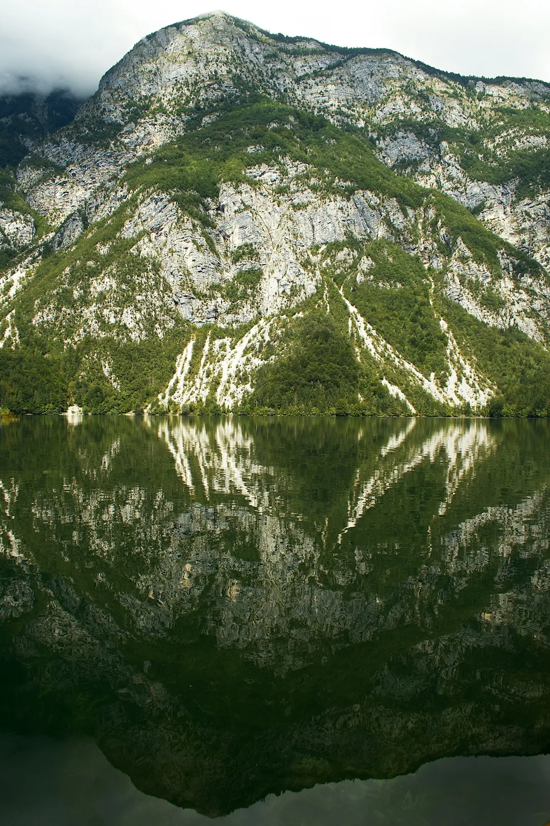
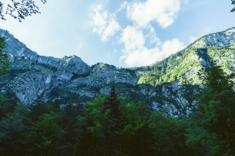
The ascent of Mount Triglav is a journey through a landscape defined by the raw power of tectonic uplift and glacial erosion. The Julian Alps, composed primarily of Triassic limestone and dolomite, provide a stark, pale grey backdrop that contrasts vividly with the deep greens of the lower valleys. The most popular and dramatic approach begins in the Vrata Valley, a deep glacial trough carved by the Bistrica stream. From here, the mountain presents its most formidable aspect: the Triglav North Face (Triglavska severna stena), a wall of rock 3 kilometres wide and 1,500 metres high. While the standard hiking routes circumvent the sheerest parts of this face, the sense of scale remains humbling throughout the climb.
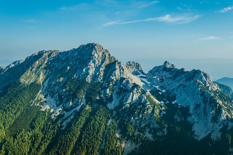
The trail is characterised by its verticality. Unlike many long-distance treks that meander through valleys, the Triglav ascent is a direct confrontation with elevation. The route from Aljažev dom in the Vrata Valley climbs relentlessly through forest and scree before reaching the high karst plateaus. Here, the landscape transforms into a lunar-like environment where water disappears into subterranean channels, leaving a surface of weathered rock, deep fissures, and resilient alpine flora. The final 400 metres of the ascent are the most technical, involving a "via ferrata" (iron path) where steel cables, pegs, and stems are anchored into the rock to assist climbers across exposed ridges. This section, particularly the narrow ridge between Mali Triglav (Little Triglav) and the main summit, offers breathtaking exposure with drops of hundreds of metres on either side.
Beyond the physical challenge, the Triglav experience is deeply social. The mountain huts (koče) are hubs of Slovenian mountaineering culture, where hikers from around the world share stories over hearty bowls of jota (sauerkraut and bean stew) or ričet (barley stew). The atmosphere is one of shared purpose and respect for the mountain. Whether you are navigating the steep "Prag" route or standing at the summit looking out toward the Adriatic Sea and the High Tauern of Austria, the Mount Triglav ascent provides a profound sense of achievement and a deep connection to the alpine heritage of Central Europe.
History and Cultural Context
The history of Mount Triglav is inextricably linked to the birth of Slovenian national identity. While the first recorded ascent took place on 26 August 1778—undertaken by four local men from Bohinj at the behest of naturalist Sigmund Zois—the mountain's symbolic importance reached its zenith in the late 19th century. During this period, the Julian Alps were part of the Austro-Hungarian Empire, and a struggle for cultural dominance was reflected in the naming and management of mountain trails between German and Slovenian mountaineering clubs.
In 1895, Jakob Aljaž, a patriotic priest from Mojstrana, purchased the very summit of Triglav for the sum of five Austro-Hungarian guilders. His goal was to ensure the peak remained in Slovenian hands. On this small patch of land, he commissioned the construction of the Aljaž Tower (Aljažev stolp), a cylindrical metal storm shelter that still stands on the summit today. The tower was carried to the top in pieces and assembled in a single day. It has since become a protected cultural monument and the primary landmark for those reaching the peak. During World War II, Triglav became a symbol of resistance for the Partisan movement, and its three-peaked silhouette was adopted as a central element of the Slovenian national consciousness after the country gained independence in 1991.
The name "Triglav" itself is a subject of much debate. While it literally translates to "Three-Headed," some historians believe it refers to an ancient Slavic deity of the same name who ruled the sky, the earth, and the underworld. Others suggest it simply describes the mountain's appearance when viewed from the south. Regardless of its etymology, the mountain remains a sacred space for Slovenians. The tradition of "baptising" first-time summiters—which involves a light, symbolic whipping with a rope while leaning against the Aljaž Tower—is still practiced with good-natured enthusiasm by local guides and hikers.
Want more background? Read extended notes on history and cultural context → Learn more
Seasonal Highlights and Weather Reality
The climbing season on Mount Triglav is relatively short, dictated by the heavy snowfall that blankets the Julian Alps for much of the year. The primary window for recreational hikers is from July to September, when the mountain huts are fully operational and the via ferrata sections are generally clear of ice.
Summer (July and August): This is the peak season. The weather is most stable, though afternoon thunderstorms are a frequent and serious hazard. During these months, the alpine wildflowers are in full bloom, including the rare Triglav Gentian and the iconic Edelweiss. However, the trails and huts can be extremely crowded, especially on weekends. It is not uncommon to encounter "traffic jams" on the final summit ridge during a clear Saturday in August.
Autumn (September to early October): Many experienced hikers consider September the best time to climb. The air is crisper and clearer, providing the best visibility for views that can stretch as far as the Gulf of Venice. The crowds thin out significantly, and the larch trees in the lower valleys begin to turn a brilliant gold. However, the days are shorter, and the first dusting of autumn snow can occur at any time, making the via ferrata sections treacherous.
Winter and Spring (November to June): During the winter months, Triglav is strictly the domain of experienced winter mountaineers and ice climbers. The mountain huts are closed (with the exception of a basic winter room at Kredarica, which is also a meteorological station), and the route requires full technical gear, including ice axes, crampons, and avalanche safety equipment. The "Prag" and "Tominšek" routes are prone to significant avalanche activity. Snow often lingers on the high plateaus well into June, meaning that even "early summer" hikers must be prepared for snow crossings and potentially buried safety cables.
Weather on Triglav is notoriously fickle. The mountain acts as a barrier between Mediterranean air masses and the continental interior, leading to rapid cloud formation and sudden temperature drops. Even in mid-summer, temperatures at the summit can hover near freezing, and wind chill can be significant. Lightning is the most acute danger; the iron cables of the via ferrata act as massive lightning rods, making the summit ridge a lethal place to be during a storm.
Recommended Itinerary
2-Day Mount Triglav Ascent (Vrata Valley Route)
Day 1: Aljažev dom to Triglavski dom na Kredarici
- Distance: 6.5 km
- Elevation gain: 1,500 m
- Time: 5–7 hours
- Start at Aljažev dom v Vratih (1,015 m) in the Vrata Valley.
- Choose between the "Prag" route (easier but steep) or the "Tominšek" route (more technical via ferrata sections).
- Ascend through the forest before emerging onto the steep limestone slopes beneath the North Face.
- Navigate the "Prag" (The Threshold), a series of steep rock steps equipped with iron pegs and cables.
- Cross the high karst plateau of Kotel, where snow often lingers.
- Arrive at Triglavski dom na Kredarici (2,515 m), Slovenia's highest mountain hut.
- Evening spent watching the sunset over the Julian Alps and preparing for the summit push.
Day 2: Kredarica to Summit and Descent to Vrata Valley
- Distance: 12.5 km (total for the day)
- Elevation: 350 m gain to summit, 1,850 m descent
- Time: 8–10 hours
- Early morning start (05:00–06:00) to avoid afternoon storms and crowds.
- Equip via ferrata gear at the hut.
- Ascend the steep ridge to Mali Triglav (2,725 m) using fixed cables and pegs.
- Traverse the famous narrow ridge between Mali Triglav and the main summit—highly exposed but well-secured.
- Reach the summit of Mount Triglav (2,864 m) and the Aljaž Tower.
- Descend back to Kredarica or Planika hut for a brief rest and lunch.
- Begin the long descent back to the Vrata Valley via the Prag route.
- Return to Aljažev dom by late afternoon for transport back to Mojstrana or Kranjska Gora.
Alternative 3-Day Itinerary (The Scenic Route)
- Day 1: Rudno Polje to Vodnikov dom (Distance: 8 km, Time: 3-4 hours). A gentler approach through spruce forests and alpine pastures.
- Day 2: Vodnikov dom to Summit via Planika Hut, then descend to Kredarica (Distance: 6 km, Time: 5-6 hours). Includes the summit push from the southern side.
- Day 3: Kredarica to Vrata Valley or back to Rudno Polje (Distance: 7-10 km, Time: 5-6 hours). A long descent to conclude the journey.
Important Notes:
- The Vrata Valley approach is the most direct but also the most physically demanding due to the rapid elevation gain.
- Always check the weather forecast at the hut before attempting the summit ridge.
- If the summit is crowded, consider waiting at Mali Triglav for a gap in the traffic.
- The descent is often harder on the knees than the ascent; trekking poles are highly recommended.
Planning and Bookings
Book Your Trip
Everything you need to plan your journey
Accommodation
Find places to stay near Kranjska Gora
Flights
Search flights to Kranjska Gora
Essential Preparation
Ascending Mount Triglav requires a high level of physical fitness and a lack of vertigo. You should be comfortable with sustained uphill movement (1,500m+ in a day) and moving on exposed rocky terrain. While you do not need to be a professional rock climber, familiarity with via ferrata equipment and techniques is essential for safety and confidence on the summit ridge.
Logistically, the best base for the climb is the village of Mojstrana or the larger resort town of Kranjska Gora. Both offer a range of accommodation, gear rental shops, and grocery stores. If you are arriving from abroad, Ljubljana Jože Pučnik Airport (LJU) is the primary gateway, located about an hour's drive from the trailhead. Public buses run regularly from Ljubljana to Kranjska Gora, with local connections to Mojstrana. From Mojstrana, a 12km road (partially gravel) leads to the Aljažev dom trailhead in the Vrata Valley. During the summer, a shuttle bus often operates on this route.
Trail Accommodation
The mountain hut system in Slovenia is well-organised and extensive. On the Triglav routes, the huts (koče) are the only permitted places to stay overnight, as wild camping is strictly prohibited within the National Park.
Key Huts:
- Triglavski dom na Kredarici (2,515 m): The largest and highest hut. It has 300 beds and is the most popular base for summit attempts. It is also a meteorological station and is manned year-round.
- Dom Planika pod Triglavom (2,401 m): Located on the southern plateau, offering a slightly shorter summit push than Kredarica. It is generally a bit quieter.
- Aljažev dom v Vratih (1,015 m): Located at the trailhead, ideal for a night before or after the climb.
Hut Facilities:
- Dormitory-style rooms (lager) and smaller private rooms (2-4 beds).
- Blankets and pillows are provided, but a personal silk or cotton sleeping bag liner is mandatory for hygiene.
- Hearty warm meals (stews, sausages, dumplings) and a selection of drinks (beer, tea, coffee).
- Limited washing facilities; water is scarce at high altitudes, so showers are rarely available.
- Electricity is usually available in common areas for charging phones, though it may be limited to certain hours.
- Toilets are typically shared and basic (composting or pit toilets at higher elevations).
Booking Requirements:
- Reservations are essential, especially for July and August. Bookings can be made through the Alpine Association of Slovenia (PZS) online portal or by contacting the huts directly via email/phone.
- Costs: A bed in a dormitory costs approximately €30–€40 per night. Members of alpine clubs (UIAA affiliated) receive a significant discount (usually 50%).
- Payment: Most huts now accept credit cards, but carrying cash (Euros) is highly recommended as satellite connections can fail.
Required Gear
- Via Ferrata Set: A Y-shaped lanyard with two carabiners and a shock absorber. This is non-negotiable for the summit ridge.
- Climbing Harness: A standard sit-harness to which the via ferrata set is attached.
- Climbing Helmet: Essential for protection against rockfall, which is a common hazard on the crowded summit routes.
- Mountaineering Boots: Sturdy, high-cut boots with a stiff sole (Vibram or similar) for grip on limestone and support on scree.
- Trekking Poles: Highly recommended for the long descent to protect knees and maintain balance on loose rock.
- Waterproof Shell: A high-quality Gore-Tex jacket and trousers. Weather can turn violent in minutes.
- Backpack: A 30–40 litre pack is sufficient for a 2-day hut-to-hut trip. Ensure it has a rain cover.
What to Bring
- Sleeping Bag Liner: Mandatory for hut stays (silk is lightest and most compact).
- Water: At least 2–3 litres. There are no water sources on the high karst plateaus, and bottled water at huts is expensive (€4–€5 per 1.5L).
- High-Energy Snacks: Nuts, dried fruit, energy bars, and chocolate for sustained effort.
- First Aid Kit: Including blister plasters (Compeed), antiseptic wipes, and any personal medications.
- Sun Protection: SPF 50+ sunscreen, lip balm with UV protection, and high-quality sunglasses (Category 3 or 4).
- Headlamp: With spare batteries, for early morning starts or navigating huts at night.
- Cash: Euros for hut meals, drinks, and emergency use.
- Clothing Layers: Merino wool base layers, a fleece or down mid-layer, and gloves (even in summer, the summit can be freezing).
- Toiletries: Toothbrush, biodegradable soap, and a small travel towel.
Permits
One of the appealing aspects of climbing Mount Triglav is that no formal permits or entry fees are required to hike the trails or summit the mountain. Triglav National Park is open to the public, and the "right to roam" is a respected principle in Slovenian mountain culture. However, this lack of a permit system means that there is no cap on the number of daily hikers, which can lead to significant congestion during peak summer weekends.
Key Regulations and Considerations:
- Hut Bookings: While not a "permit," your hut reservation is your de facto permission to stay on the mountain. During the high season, you will likely be turned away from huts if you do not have a booking, as they frequently reach maximum capacity.
- National Park Rules: Strict regulations apply within Triglav National Park. Wild camping and bivouacking are strictly prohibited and can result in heavy fines from park rangers. Hikers must stay on marked trails to prevent erosion and protect sensitive alpine flora.
- Parking Fees: If you are driving to the trailhead in the Vrata Valley, be prepared to pay a daily parking fee at the Aljažev dom car park (typically €10–€15 per day during the summer season).
- Insurance: While not a legal requirement, it is highly recommended to have mountain rescue insurance. Members of the Slovenian Alpine Association (PZS) or other international alpine clubs (like the Austrian Alpine Club) are automatically covered for rescue costs in the Slovenian Alps. Without this, a helicopter evacuation can cost several thousand Euros.
Registration: It is good practice to sign the guest book at Aljažev dom before you start and at Kredarica when you arrive. This helps mountain rescue services (GRS) track the number of people on the mountain in the event of a major storm or emergency.
Other Activities in the Area
The Julian Alps and the surrounding Gorenjska region offer a wealth of activities for those looking to extend their stay in Slovenia:
- Lake Bled: Only 30 minutes from Mojstrana, this iconic lake features a cliffside castle and a church-topped island. It is the perfect place for a post-hike swim and a slice of the famous "Kremna rezina" (cream cake).
- Vršič Pass: Slovenia's highest mountain pass, featuring 50 hairpin bends and stunning views. It is a gateway to the Soča Valley and offers numerous shorter day hikes, such as the climb to Mojstrovka.
- The Soča Valley: Known for its emerald-green river, this valley is a world-class destination for white-water rafting, kayaking, and fly-fishing. It also holds significant WWI history along the "Walk of Peace."
- Peričnik Waterfall: Located in the Vrata Valley on the way to Triglav, this spectacular 52-metre fall allows you to walk directly behind the curtain of water.
- Planica Nordic Centre: Visit the world-famous ski jumping hills near Kranjska Gora, where you can try one of the world's steepest zip-lines that mimics the flight of a ski jumper.
- Radovna Valley: A peaceful glacial valley perfect for cycling, leading to the stunning Vintgar Gorge near Bled.
Safety and Conditions
Pre-Departure Checks:
- Check the specialized mountain forecast provided by ARSO (Slovenian Environment Agency). General weather apps are often inaccurate for high-altitude conditions.
- Consult with the staff at the Slovenian Alpine Museum in Mojstrana or the wardens at Aljažev dom for the latest track conditions, especially regarding snow levels on the Prag route.
- Ensure your via ferrata gear is in good condition and that you know how to use it. If you are inexperienced, consider hiring a certified IFMGA mountain guide.
Objective Hazards:
- Lightning: This is the single greatest weather-related danger on Triglav. The summit ridge is extremely exposed. If a storm is approaching, descend immediately. Do not attempt the summit if thunder is audible or if the sky is darkening.
- Rockfall: The limestone of the Julian Alps is prone to crumbling. Rockfall can be triggered by wind, rain, or other hikers above you. Always wear a helmet on the technical sections.
- Exposure: The ridge between Mali Triglav and the summit has vertical drops of over 500 metres. While the path is wide enough for two people to pass and is well-secured with cables, it can be mentally taxing for those with a fear of heights.
- Fatigue: The 1,500m+ descent back to the Vrata Valley is punishing. Many accidents occur on the descent due to tired legs and loss of concentration. Pace yourself and stay hydrated.
Emergency Contacts: In the event of an accident, the European emergency number is 112. The Mountain Rescue Association of Slovenia (Gorska reševalna služba - GRS) is a highly professional, mostly volunteer organisation that handles all alpine rescues. If you have no phone signal, try to reach the nearest hut, as they all have radio links to the valley.
Navigation: The trails are exceptionally well-marked with the "Knafelc mark"—a white dot surrounded by a red ring. However, in thick fog (which is common), these can be hard to spot on the grey limestone plateaus. Carrying a GPS with offline maps or a 1:25,000 scale topographic map of the Julian Alps is essential.
Side Trips and Points of Interest
The Aljaž Tower (Aljažev stolp): The ultimate goal of the ascent. This tiny, circular storm shelter has stood on the summit since 1895. Inside, there is barely enough room for three people to stand, but it has provided life-saving shelter to many caught in sudden storms. It is the most photographed object in the Slovenian mountains.
The Triglav Glacier (Triglavski ledenik): Located just below the summit on the northern side, this was once a significant glacier. Today, due to climate change, it has shrunk to a small patch of permanent snow and ice (a "glacieret"). It is a sobering place to reflect on the changing alpine environment.
Luknja Pass: For those descending via the southern side or looking for a more challenging route, the Luknja Pass (1,758 m) offers a dramatic notch in the ridge with views down into the Vrata and Zadnjica valleys. The "Bamberg" route to the summit starts here and is considered the most difficult of the standard via ferratas.
The North Face Viewpoints: Even if you don't climb the face itself, the views from the Tominšek trail offer incredible perspectives of the "Slovenian Pillar" and other famous climbing routes. The sheer scale of the 1,500m wall is best appreciated in the soft light of early morning.
Seven Lakes Valley: If you have 3–4 days, you can extend your Triglav trip by descending the southern side into the Valley of the Seven Triglav Lakes. This is one of the most beautiful parts of the National Park, featuring a series of alpine tarns ranging from deep green to turquoise, surrounded by larch forests and karst peaks.
Leave No Trace
Mount Triglav is the centerpiece of Slovenia's only National Park. The alpine environment here is extremely fragile; the growing season for plants at 2,500 metres is only a few weeks long, and the thin soils are easily eroded. With thousands of people visiting the summit every year, the cumulative impact can be devastating if Leave No Trace principles are not strictly followed.
Guidelines for Triglav:
- Waste Management: Pack out everything you pack in. This includes organic waste like banana peels and apple cores, which decompose very slowly in the cold, dry alpine air. Do not leave trash in the mountain huts; they have to fly all waste out by helicopter at great expense.
- Stay on the Path: Short-cutting switchbacks causes massive erosion and destroys the delicate alpine turf. Stick to the marked Knafelc trails.
- Respect Wildlife: You are likely to see Chamois (gams) and Alpine Ibex (kozorog). Observe them from a distance and never attempt to feed them. Feeding wildlife disrupts their natural foraging habits and can make them dependent on humans.
- Water Conservation: Water is a precious resource in the karst landscape. Use it sparingly in the huts and never use soap or detergent in alpine lakes or streams.
- Noise Pollution: The mountains are a place for quiet reflection. Avoid loud music or shouting, which can disturb both wildlife and other hikers seeking a wilderness experience.
- Human Waste: Use the toilets provided at the huts. If you are caught short on the trail, move at least 50 metres from the path and water sources, and bury your waste in a "cathole" or, better yet, use a "wag bag" to pack it out.