Morocco — Marrakech
Ascend North Africa's highest peak, Mount Toubkal (4,167m), on this demanding 63km, 2-3 day route through Morocco's High Atlas Mountains. Traverse rugged slopes and high passes within Toubkal National Park, immersing yourself in the rich Amazigh culture. This challenging trek offers breathtaking panoramas and a true test of endurance.
Distance: 63.0 km
Elevation Gain: 2167 m
Difficulty: Challenging
Duration: 2-3 days
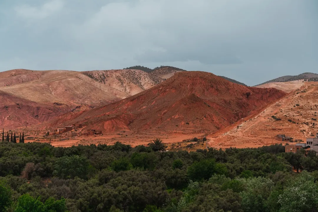
Mount Toubkal, or Jebel Toubkal, stands as the undisputed monarch of the High Atlas Mountains and the highest peak in North Africa, reaching a formidable elevation of 4,167 metres. Located within the Toubkal National Park in southwestern Morocco, this majestic peak offers a trekking experience that seamlessly blends high-altitude physical challenge with the profound cultural richness of the indigenous Amazigh (Berber) people. Unlike many of the world's great peaks that require technical mountaineering skills, Toubkal is primarily a non-technical "trekking peak" during the summer months, making it an accessible yet deeply rewarding objective for fit hikers. The journey begins in the vibrant, walnut-shaded village of Imlil, ascending through stark, terracotta-coloured valleys and ancient stone villages before reaching the high alpine zone where granite crags and snow-filled couloirs dominate the horizon. To stand upon the triangular metal pyramid at the summit is to witness a panorama that stretches from the shimmering heat of the Sahara Desert to the south to the jagged, snow-capped ridges of the Atlas range extending toward the Atlantic coast.
The ascent of Mount Toubkal is far more than a mere peak-bagging exercise; it is an immersion into a landscape that feels both ancient and eternal. The High Atlas Mountains form a dramatic barrier between the Mediterranean climate of the north and the arid expanse of the Sahara to the south. This geographical position creates a unique environment where lush, irrigated valley floors—filled with apple orchards, cherry trees, and ancient walnut groves—give way to a high-altitude wilderness of scree, basalt, and limestone. The 63-kilometre route described here takes the more scenic and physically demanding approach via the Azzaden Valley, providing essential acclimatisation and a broader perspective of the Toubkal massif before the final summit push.
The trek is characterised by its dramatic verticality. Hikers transition from the bustling trailhead at Imlil, where mules are loaded with supplies and the scent of tagine wafts through the air, to the silent, thin-aired heights of the Toubkal Refuge at 3,207 metres. The terrain is rugged and uncompromising. Expect to navigate steep "mule paths" that zigzag up mountain passes (tizis), cross boulder-strewn riverbeds, and tackle the infamous scree slopes of the South Cirque. The physical demand is significant, particularly on the summit day when the air thins and the gradient steepens, but the logistical support provided by local guides and muleteers allows trekkers to focus on the rhythm of their breath and the unfolding majesty of the mountains.
Culturally, the trek is equally enriching. The High Atlas is the heartland of the Amazigh people, whose stone and mud-brick villages cling precariously to the hillsides. Their hospitality is legendary, and the experience of sharing mint tea in a remote mountain gite or watching a muleteer navigate a treacherous path with effortless grace is as much a part of the Toubkal experience as the summit itself. This is a landscape where tradition remains the bedrock of daily life, and the mountains are respected as both a source of life and a formidable challenge to be navigated with care and humility.
The history of Mount Toubkal is inextricably linked to the Amazigh (Berber) people, who have inhabited these valleys for millennia. For the local populations, the mountains were not seen as peaks to be "conquered" in the Western sense, but as sacred spaces and vital sources of water and summer grazing for their livestock. The high passes were ancient trade routes connecting the sub-Saharan caravans with the imperial cities of the north. Even today, the presence of "marabouts" (shrines of holy men) throughout the park, such as the famous Sidi Chamharouch, highlights the spiritual significance of the landscape.
The European "discovery" and formal exploration of Toubkal began during the French Protectorate in the early 20th century. The first recorded ascent by Europeans took place on 12 June 1923, led by the Marquis de Ségonzac, accompanied by Vincent Berger and Hubert Dolbeau. They were guided by local residents who had long known the routes but had little reason to stand on the very highest point. Following this ascent, the French Alpine Club (Club Alpin Français) established the first mountain refuges, laying the groundwork for the modern trekking industry. The Toubkal National Park was officially established in 1942, the first of its kind in Morocco, to protect the unique biodiversity and geological heritage of the region.
In recent decades, the area has seen a significant shift toward sustainable mountain tourism. The village of Imlil has transformed from a quiet agricultural outpost into the premier trekking hub of North Africa. However, the cultural core remains intact. The Amazigh language (Tamazight) is spoken throughout the valleys, and the social structure remains centred around the village assembly (Jmaa). In 2018, following safety concerns, the Moroccan government implemented a mandatory guide policy for all trekkers attempting the summit, a move that has further integrated the local community into the trekking economy and ensured that the history and stories of the mountains continue to be shared with every visitor.
Want more background? Read extended notes on history and cultural context → Learn more
The High Atlas Mountains experience a true four-season climate, and the experience of climbing Toubkal varies dramatically depending on the month. Understanding these seasonal shifts is crucial for safety and enjoyment.
Spring (April to May): This is widely considered the "golden window" for trekking. The lower valleys are in full bloom, with wildflowers carpeting the meadows and the walnut trees leafing out in vibrant green. At higher elevations, snow still clings to the couloirs and the summit, providing a stunning contrast against the deep blue sky. While the air is crisp and clear, trekkers must be prepared for lingering snow patches that may require crampons and an ice axe, especially in early April. Daytime temperatures are pleasant for walking, though nights at the refuge remain near freezing.
Summer (June to August): Summer brings intense heat to the Moroccan lowlands, making the mountains a popular escape. While the high-altitude air is cooler, the sun is exceptionally strong, and the trek can be punishingly hot during the middle of the day. The snow has usually melted entirely from the main routes, making it a straightforward walk-up. However, afternoon thunderstorms are common, and the lack of shade on the upper slopes increases the risk of heat exhaustion and dehydration. Early starts (often 4:00 AM or 5:00 AM) are essential to avoid the worst of the heat.
Autumn (September to October): Another prime trekking season. The summer heat has dissipated, and the air becomes incredibly clear, offering the best long-distance views. The landscape takes on a golden hue as the harvest begins in the valleys. The first dustings of winter snow usually arrive in late October, signalling the end of the trekking season and the beginning of the mountaineering season. This period offers stable weather and comfortable walking temperatures.
Winter (November to March): During the winter months, Mount Toubkal transforms into a serious alpine environment. The trek becomes a technical mountaineering expedition requiring crampons, ice axes, and knowledge of avalanche safety. Temperatures at the summit can drop to -20°C, and fierce winds are common. While the scenery is spectacular, this season is only recommended for those with winter mountain experience or those accompanied by specialised alpine guides.
Day 1: Imlil to Azzaden Valley (Ait Aissa)
Day 2: Ait Aissa to Toubkal Refuge via Aguelzim Pass
Day 3: Toubkal Refuge to Summit and return to Imlil
Important Notes:
Preparation for Mount Toubkal involves both physical training and logistical coordination. Physically, you should be comfortable with long days of uphill walking (6–9 hours) on uneven terrain. Cardiovascular fitness is important, but leg strength and endurance are the primary requirements. Training on hills or using a stair-climber with a weighted pack is excellent preparation.
Logistically, Marrakech is the primary gateway. Most trekkers spend a night or two in Marrakech to adjust to the heat and organise their gear. From Marrakech, a "grand taxi" or private transfer to Imlil takes approximately 90 minutes. It is highly recommended to book your guide and trek in advance through a reputable local agency, as they will handle the mule logistics, gite bookings, and refuge reservations. Since 2018, you cannot pass the police checkpoints at Aroumd without a registered guide.
Accommodation on the Toubkal trek ranges from simple village gites to high-altitude mountain refuges. The quality is generally high, but facilities are communal and rustic.
Hut and Gite Facilities:
What Accommodation Doesn't Provide:
Booking Requirements:
There is no "permit" in the traditional sense of a lottery or a paper document you buy in advance. Instead, access to Mount Toubkal is strictly regulated through a mandatory guide system and police checkpoints. This system was implemented to ensure the safety of trekkers and to support the local economy.
The Checkpoint System:
Guide Requirements:
National Park Fees:

Detailed route notes, maps, logistics & tips for the Mount Toubkal Summit (PDF).

Precisely traced GPX for the Mount Toubkal Summit, ready for your GPS or favourite mapping app.
Morocco offers a wealth of experiences that complement a Toubkal trek. Consider these options for before or after your climb:
Altitude Sickness (AMS): Acute Mountain Sickness is the primary safety concern on Toubkal. At 4,167 metres, the air contains significantly less oxygen than at sea level. Symptoms include headache, nausea, dizziness, and fatigue. The best prevention is a slow ascent (which is why the 3-day Azzaden route is superior), staying hydrated (3–4 litres of water per day), and "climbing high, sleeping low." If symptoms persist or worsen, the only cure is immediate descent. Your guide is trained to recognise these signs, and their advice should be followed without question.
Weather Volatility: The High Atlas can experience rapid weather changes. A clear morning can transform into a violent thunderstorm or a whiteout within an hour. High winds on the summit ridge are common and can significantly increase the risk of hypothermia. Always carry your waterproof and insulating layers, even if the sun is shining at the trailhead.
Terrain Hazards: The descent from the summit involves long stretches of loose scree. This is physically taxing and increases the risk of slips and ankle injuries. Use your trekking poles and follow your guide's lead on the best "lines" through the scree. In winter or early spring, the couloirs are prone to avalanches; never attempt these routes without expert guidance and proper equipment.
Mandatory Guides: The guide is not just a cultural liaison but a critical safety asset. They know the terrain, the weather patterns, and the emergency evacuation procedures. In the event of an injury, the guide will coordinate with the local muleteers or, in extreme cases, the Royal Moroccan Air Force for helicopter evacuation (though this is rare and weather-dependent).
Travel Insurance: Ensure your travel insurance specifically covers "trekking up to 4,500 metres." Many standard policies exclude high-altitude activities. Verify that emergency medical evacuation is included.
Sidi Chamharouch Shrine: Located at 2,350 m on the main trail from Imlil to the refuge, this is a fascinating cultural landmark. The shrine, built around a massive white-painted boulder, is dedicated to the "King of the Jinns" (spirits). It is a place of pilgrimage for many Moroccans seeking spiritual healing. While the shrine itself is off-limits to non-Muslims, the surrounding cluster of shops and cafes is a popular resting spot for trekkers.
The Lockheed Constellation Wreckage: For those with extra time and energy, a detour into the neighbouring valleys can lead to the site of a 1969 plane crash. The wreckage of a Lockheed Constellation remains scattered across the mountainside, a haunting and unusual sight in such a remote wilderness. This requires an experienced guide to locate.
Lake Sidi Ifni: One of the highest alpine lakes in the Atlas, situated at 2,295 m. It is a stunning turquoise jewel surrounded by jagged peaks. Reaching the lake usually requires an extra day or a longer circuit, but it offers a serene alternative to the busier summit routes.
Tizi n'Tamatert: A pass near Imlil that offers spectacular views of the Imlil and Imnane Valleys. It is an excellent "warm-up" walk for those arriving a day early in Imlil to acclimatise.
Imlil Waterfalls: A short, easy walk from the centre of Imlil leads to a series of refreshing waterfalls. It is a popular spot for locals and a great place to relax your feet in the cold mountain water after your trek.
The Toubkal National Park is a fragile ecosystem under increasing pressure from tourism. As a trekker, you have a responsibility to minimise your impact on this unique environment and respect the local communities that call it home.
Environmental Responsibility:
Cultural Respect: