Mount Toubkal - The Roof of North Africa
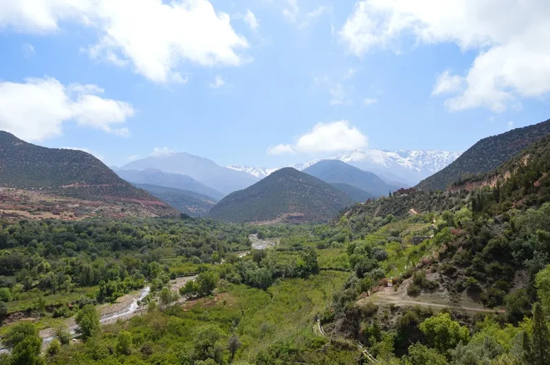
Mount Toubkal, or Jebel Toubkal, stands as the undisputed monarch of the High Atlas Mountains and the highest peak in North Africa, reaching a formidable elevation of 4,167 metres. Located within the Toubkal National Park in southwestern Morocco, this majestic peak offers a trekking experience that transcends simple mountain climbing. It is a journey through a landscape of stark, high-altitude beauty, ancient Berber (Amazigh) culture, and challenging terrain that tests the endurance of even seasoned hikers. Unlike many of the world's highest summits, Toubkal is accessible to fit trekkers without requiring technical mountaineering skills during the summer months, yet it retains a sense of wild isolation and grandeur that is increasingly rare in modern adventure travel. The trek typically begins in the vibrant mountain village of Imlil, winding through walnut groves and terraced fields before ascending into a world of jagged basalt, deep scree slopes, and permanent snow patches that linger in the shadows of the giants.
- Distance: 63.0 km (Circuit/Extended Route)
- Duration: 2–3 days
- Season: April to May and September to October (Best for trekking); December to March (Winter mountaineering)
- Accommodation: Refuges (Refuge du Toubkal and Les Mouflons)
- Highest point: Toubkal Summit (4,167 m)
- Difficulty: Challenging (High altitude and steep scree)
- Closest City: Marrakech (approx. 65 km)
Overview
The ascent of Mount Toubkal is a masterclass in ecological and cultural transition. Starting from the lush, irrigated valleys of the Imlil region at approximately 1,740 metres, trekkers are initially greeted by the scent of juniper and the sight of ancient walnut trees. As the trail climbs, the greenery gives way to a more austere, lunar landscape. The High Atlas is a range of dramatic contrasts; the lower slopes are home to resilient Berber communities who have carved a living out of the mountainside for millennia, while the upper reaches are a kingdom of rock and sky. The 63-kilometre route encompasses not just the summit push, but a broader exploration of the surrounding valleys, providing a comprehensive understanding of the massif's scale and the intricate relationship between the local people and their environment.
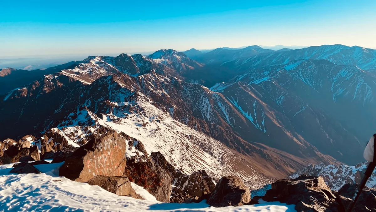
Physically, the trek is demanding. While the paths are generally well-defined, the sheer elevation gain—over 2,100 metres from the trailhead—requires significant cardiovascular fitness and mental fortitude. The final summit day is particularly notorious for its "scree runs"—steep slopes of loose rock that can be as frustrating on the ascent as they are exhilarating (or knee-jarring) on the descent. However, the reward for this exertion is unparalleled. From the summit, marked by a distinctive metal tripod, the views stretch across the entire Atlas range, south toward the shimmering heat of the Sahara Desert, and north toward the Haouz Plain and the distant, hazy silhouette of Marrakech. It is a perspective that humbles the spirit and provides a profound sense of achievement.
The experience is also deeply social. The trail is a conduit for interaction, whether it is sharing mint tea with a local guide, nodding to muleteers as they navigate the rocky paths with impossible grace, or swapping stories with international trekkers in the communal atmosphere of the high-altitude refuges. In recent years, safety regulations have formalised the trekking experience, requiring all hikers to be accompanied by a local guide. This has not only enhanced safety but has also deepened the cultural immersion, as guides provide invaluable insights into the history, geology, and traditions of the "Land of the Berbers."
History and Cultural Context
The history of Mount Toubkal is inextricably linked to the Berber people, the indigenous inhabitants of North Africa. For centuries, the High Atlas served as a natural fortress and a source of life-sustaining water for the plains below. While the local communities have always lived in the shadow of the peak, the concept of "summiting" for recreation was largely a European introduction. The first recorded ascent of Mount Toubkal by Westerners took place on 12 June 1923, by the Marquis de Segonzac, Vincent Berger, and Hubert Dolbeau. This event marked the beginning of the Atlas Mountains' reputation as a premier destination for alpine exploration outside of Europe.
Culturally, the mountain is more than just a physical challenge. Along the route to the summit lies the shrine of Sidi Chamharouch, a site of great spiritual significance. Known as the "King of the Jinns," the shrine attracts pilgrims from across Morocco who seek healing and spiritual intervention. The presence of this white-painted boulder and the surrounding cluster of small shops and dwellings serves as a reminder that the mountains are a sacred space, inhabited by spirits and steeped in folklore. Respecting these local beliefs is a fundamental part of the trekking experience.
The Berber culture itself is a highlight of the journey. The architecture of the villages, with houses built of stone and earth that seem to grow directly out of the mountainside, reflects a deep harmony with the landscape. The traditional agricultural systems, involving complex irrigation channels (seguias) and terraced plots, demonstrate a sophisticated understanding of mountain ecology. Today, the trekking industry is a vital part of the local economy, providing employment for guides, muleteers, and guesthouse owners, ensuring that the ancient traditions of hospitality continue to thrive in the modern era.
Want more background? Read extended notes on history and cultural context → Learn more
Seasonal Highlights and Weather Reality
Timing is everything when planning a Toubkal ascent. The mountain experiences a true four-season climate, with conditions varying wildly between the valley floor and the summit. The most popular windows for trekking are the shoulder seasons of spring (April to May) and autumn (September to October). During these months, the temperatures in Marrakech are manageable, and the mountain air is crisp and clear. In spring, the lower valleys are in full bloom, and the contrast between the green fields and the snow-capped peaks is visually stunning. Autumn offers stable weather and excellent visibility, though the landscape is drier after the summer heat.
Summer (June to August) can be punishingly hot in the lower sections of the trek, with temperatures in Imlil often exceeding 30°C. However, the high altitude provides a natural escape from the sweltering heat of the plains. Trekkers during this period must be diligent about hydration and sun protection. The summit itself remains cool, and even in mid-summer, a fleece or light jacket is usually required at the top. This is the best time for those who wish to avoid snow and ice, as the trails are typically clear.
Winter (November to March) transforms Toubkal into a serious alpine environment. The mountain is covered in snow, and the ascent requires technical equipment, including crampons and ice axes, along with the knowledge of how to use them. Temperatures at the refuges can drop well below freezing, and the summit can experience fierce winds and whiteout conditions. For experienced mountaineers, winter offers a spectacular and quiet experience, but it is not for the unprepared. Regardless of the season, weather in the High Atlas can change with startling rapidity; afternoon thunderstorms are common in summer, and sudden mists can obscure the trail at any time of year.
Recommended Itinerary

3-Day Toubkal Circuit and Summit Itinerary
Day 1: Imlil to Toubkal Refuge via Sidi Chamharouch
- Distance: 12 km
- Elevation gain: 1,467 m
- Time: 5–6 hours
- Start in the village of Imlil (1,740 m) after a final gear check
- Follow the Mizane Valley, passing the village of Aroumd, built on a massive moraine spur
- Cross the floodplains and begin the steady ascent toward the shrine of Sidi Chamharouch (2,350 m)
- Stop for a break and fresh orange juice at the shrine, observing the local pilgrims
- Continue the climb on a well-trodden but rocky path as the vegetation thins out
- Arrive at the Toubkal Refuges (3,207 m) in the late afternoon
- Settle into the refuge (either Refuge du Toubkal or Les Mouflons) and focus on hydration and acclimatisation
- The evening is spent in the communal dining hall, preparing for the early summit push
Day 2: Summit Day - Refuge to Toubkal Peak and Descent to Imlil
- Distance: 15 km (Summit and return to Imlil)
- Elevation: 960 m gain to summit, 2,427 m descent to Imlil
- Time: 8–10 hours
- Pre-dawn start (usually between 4:00 AM and 5:00 AM) to catch the sunrise and avoid afternoon clouds
- The ascent begins with a steep climb up the south cirque, navigating large boulders and loose scree
- The path zigzags upward, requiring a steady pace to manage the thinning air
- Reach the Tizi n'Toubkal pass (3,940 m) before the final ridge walk to the summit
- Summit Mount Toubkal (4,167 m) – enjoy 360-degree views of the Atlas and the Sahara
- Begin the long descent back to the refuge for a well-earned lunch
- Continue the descent past Sidi Chamharouch all the way back to Imlil
- This is a physically exhausting day due to the significant descent, but the sense of achievement is immense
Day 3: Imlil Valley Exploration and Return to Marrakech
- Distance: 8–10 km (Optional valley walk)
- Elevation: Minimal
- Time: 3–4 hours
- A more relaxed day to recover and soak in the local culture
- Take a guided walk through the terraced fields and walnut groves of the Imlil and Ait Mizane valleys
- Visit a local Berber home for traditional mint tea and bread with honey and argan oil
- Explore the local workshops where artisans create traditional carpets and woodwork
- After lunch in Imlil, take a pre-arranged transfer or Grand Taxi back to Marrakech
- Arrive in Marrakech by late afternoon, transitioning from the silence of the mountains to the energy of the Medina
Important Notes:
- A local guide is mandatory for all trekkers (security checkpoints are in place)
- Mules can be hired in Imlil to carry heavy packs to the refuge, which is highly recommended
- Altitude sickness (AMS) is a genuine risk; stay hydrated and inform your guide of any symptoms
- The "scree" on the descent can be slippery; trekking poles are essential for stability
- Refuges provide mattresses, but a 3-season sleeping bag is necessary for warmth and hygiene
Planning and Bookings
Book Your Trip
Everything you need to plan your journey
Accommodation
Find places to stay near Marrakech
Flights
Search flights to Marrakech
Essential Preparation
Preparation for Mount Toubkal begins long before you reach the trailhead. While not a technical climb, the altitude and steepness require a good level of cardiovascular fitness. Training should focus on hill walking and leg strength. Logistically, the most important step is arranging a local guide. Since 2018, Moroccan authorities have mandated that all hikers on Toubkal must be accompanied by a certified guide. This can be organised in advance through a trekking agency or upon arrival in Imlil at the Bureau des Guides.
Marrakech is the primary gateway. Most trekkers spend a night or two in the city to adjust to the Moroccan climate and organise last-minute supplies. From Marrakech, a 90-minute drive takes you to Imlil. It is advisable to book your transport in advance or use a "Grand Taxi" from the Bab Er Robb station. Ensure you have sufficient Moroccan Dirhams (MAD), as there are no ATMs in the high mountains and credit cards are rarely accepted outside of major hotels in Imlil.
Trail Accommodation
Accommodation on the Toubkal trek is divided between the village of Imlil and the high-altitude refuges. In Imlil, options range from basic trekkers' hostels to luxury kasbahs. On the mountain itself, there are two primary refuges located side-by-side at 3,207 metres.
Refuge du Toubkal (Neltner) and Les Mouflons:
- Dormitory-style sleeping arrangements with bunk beds and mattresses
- Shared bathroom facilities with cold (and occasionally lukewarm) showers
- Large communal dining areas where traditional Moroccan meals (tagine, couscous) are served
- Small shops selling snacks, bottled water, and soft drinks
- Blankets are usually provided, but a personal sleeping bag is essential for hygiene and extra warmth
- No heating in the dormitories; it can be very cold at night even in summer
- Limited electricity for charging devices (often a small fee applies)
Booking Requirements:
- Advance booking is highly recommended, especially during peak seasons (April-May, Sept-Oct)
- Bookings can be made directly with the refuges via their websites or through your trekking guide
- Costs: Approximately 250–350 MAD per night, including dinner and breakfast
- Camping is permitted in designated areas near the refuges for a smaller fee, but you must provide all your own equipment
Required Gear
- Trekking boots - Sturdy, waterproof, and well broken-in. Ankle support is vital for the scree slopes
- Trekking poles - Highly recommended to save your knees on the long descent and provide stability on loose rock
- Backpack - 30–40L for a day pack if using a mule, or 50–65L if carrying your own gear
- Sleeping bag - 3-season (comfort rating 0°C to -5°C) for the refuge; 4-season for winter
- Head torch - Essential for the pre-dawn summit start; bring spare batteries
- Waterproof jacket and trousers - Breathable (Gore-Tex or similar) to protect against wind and sudden rain
- Insulating layers - Fleece or down jacket for the cold mornings and summit
- Gloves and beanie - Even in summer, the summit is cold and windy
What to Bring
- Water purification - Tablets or a filter (e.g., LifeStraw or Sawyer). While bottled water is sold, reducing plastic waste is preferred
- High-energy snacks - Nuts, dried fruit, chocolate, and energy bars for the summit push
- Sun protection - SPF 50+ sunscreen, lip balm with SPF, and high-quality sunglasses (UV is intense at 4,000 m)
- Personal first aid kit - Including blister plasters (Compeed), rehydration salts, and ibuprofen
- Toiletries - Biodegradable soap, wet wipes, and a small travel towel
- Personal medications - Including Diamox if you have discussed altitude medication with your doctor
- Cash (Moroccan Dirhams) - For tips, snacks, and refuge payments
- Camera and power bank - To capture the views and keep your phone charged for navigation/photos
Permits

Technically, there is no "permit" in the sense of a limited-entry ticket like the Inca Trail. However, the regulatory environment is strict. Following a security incident in 2018, the Moroccan government implemented mandatory guide requirements for all trekkers entering the Toubkal National Park. You cannot legally pass the checkpoints without a certified guide.
The Checkpoint System:
- There are permanent police checkpoints at the entrance to Imlil and at the shrine of Sidi Chamharouch
- You will be required to show your passport at these checkpoints; your guide will handle the registration process
- Ensure you have a physical copy or a clear photo of your passport on your phone
- The guide's certification will also be verified by the authorities
Costs and Logistics:
- Guide fees: Expect to pay between 400 and 600 MAD per day for a private guide. This fee usually covers the guide's expertise but not their food/accommodation (though this is often bundled in agency packages)
- Mule hire: Approximately 150–200 MAD per day. One mule can typically carry the bags of two trekkers
- National Park fees: Currently, there is no separate entry fee for the park itself, as the costs are effectively managed through the guide and refuge system
Booking a Guide: It is best to book a guide through a reputable agency in Marrakech or Imlil. This ensures that the guide is officially certified by the Moroccan Ministry of Tourism. Independent guides can be found in Imlil, but always ask to see their official "Carte de Guide" to ensure they are authorised to take you to the summit.
Other Activities in the Area
The High Atlas and the surrounding regions offer a wealth of experiences beyond the summit of Toubkal:
- Marrakech Medina: Explore the UNESCO-listed old city, the Jemaa el-Fnaa square, and the intricate souks. It is the perfect cultural counterpoint to the mountains.
- Ourika Valley: A popular day trip from Marrakech, known for its waterfalls (Setti Fatma) and lush riverside restaurants.
- Azzaden Valley: For those seeking a quieter trekking experience, the Azzaden Valley offers beautiful red-rock scenery and more traditional Berber villages.
- Rock Climbing: The granite and basalt cliffs around Imlil and the refuges offer excellent traditional and sport climbing opportunities for those with the gear and experience.
- Mountain Biking: The lower Atlas trails are increasingly popular for rugged mountain biking tours, though many paths are technically demanding.
- Oukaimeden: Morocco's premier ski resort, located about 80 km from Marrakech. In winter, it offers a unique African skiing experience; in summer, it is a base for high-altitude hiking and viewing ancient petroglyphs.
Safety and Conditions
Altitude Sickness (AMS): At 4,167 metres, Mount Toubkal is high enough for Acute Mountain Sickness to be a serious concern. Symptoms include headache, nausea, dizziness, and fatigue. The best prevention is a slow ascent, staying well-hydrated (3–4 litres of water per day), and avoiding alcohol. If symptoms persist or worsen, the only cure is to descend immediately. Your guide is trained to recognise these signs, so be honest about how you are feeling.
Weather Hazards: The High Atlas is prone to sudden weather shifts. In summer, heat exhaustion is a risk on the lower slopes, while the summit can be surprisingly cold. Afternoon thunderstorms can bring lightning and heavy rain, making the rocky paths slippery. In winter, the risks escalate to include avalanches, extreme cold, and the need for technical ice skills. Always check the mountain forecast before leaving Imlil.
Terrain and Footing: The "scree" on Toubkal is legendary. These slopes of loose, golf-ball-sized rocks can be unstable. On the ascent, it is energy-sapping; on the descent, it is easy to slip and twist an ankle. Trekking poles are not just an accessory here—they are essential safety equipment. Ensure your boots have deep lugs and good ankle support.
Water Safety: Never drink untreated water from streams, as livestock (mules, goats) graze throughout the mountains. Use purification tablets, a filter, or purchase bottled water at the refuges. Dehydration significantly increases the risk of altitude sickness, so drink more than you think you need.
Emergency Services: Rescue services in the High Atlas are limited compared to the European Alps. In the event of a serious injury, evacuation is typically done by mule to Imlil and then by road to Marrakech. Helicopter rescues are rare and extremely expensive. Comprehensive travel insurance that specifically covers "trekking up to 4,500m" is mandatory.
Side Trips and Points of Interest
The 1969 Plane Wreck: For those taking the "Circuit" route or an alternative descent, the remains of a Lockheed C-130 Hercules that crashed in 1969 are still visible on the mountainside. The wreckage is scattered across a wide area and serves as a somber and surreal landmark amidst the natural beauty of the Atlas.
Sidi Chamharouch: This shrine is a fascinating cultural stop. The large white boulder is said to house the King of the Jinns. While non-Muslims are not permitted to enter the shrine itself, the surrounding village is a great place to observe Moroccan mountain life and enjoy a glass of tea. The atmosphere is a unique blend of commerce and spirituality.
Lake Ifni: Located on the southern side of the Toubkal massif, this is the highest lake in Morocco. It is a stunning turquoise jewel surrounded by towering cliffs. Reaching the lake usually requires an extra day or two on your itinerary, but it offers a peaceful and spectacular camping spot far from the main summit crowds.
Aroumd Village: Built on a massive spur of rock overlooking the Mizane Valley, Aroumd is one of the most picturesque villages in the Atlas. Walking through its narrow, winding streets provides a glimpse into the daily lives of the Berber people. The village is famous for its hospitality and its views back toward the Toubkal summit.
Tizi n'Aguelzim: A high pass (3,560 m) often used on the 3-day circuit. It offers one of the best panoramic views of the Toubkal massif and the zig-zagging path down to the refuges. It is a challenging climb but provides a much more scenic approach than the standard Mizane Valley route.
Leave No Trace
The Toubkal National Park is a fragile high-altitude ecosystem under increasing pressure from tourism. As a trekker, your impact can be significant. The "Leave No Trace" principles are essential to preserving this landscape for the Berber communities and future adventurers.
Environmental Responsibility:
- Pack out all trash. This includes organic waste like orange peels and nut shells, which decompose very slowly in the cold, dry mountain air
- Avoid purchasing plastic water bottles where possible; use a reusable bottle and purification system
- Stay on the established trails to prevent erosion and protect the sparse alpine vegetation
- Use the toilet facilities at the refuges and Sidi Chamharouch. If you must go on the trail, ensure you are at least 60 metres from water sources and bury waste deeply
Cultural Respect:
- Dress modestly, especially when passing through villages. Shoulders and knees should ideally be covered
- Always ask permission before taking photos of local people, especially women and children
- Respect the sanctity of the Sidi Chamharouch shrine and other religious sites
- Support the local economy by hiring local guides and muleteers and purchasing handicrafts directly from artisans
- Be mindful of water use; it is a precious resource in the mountains
By walking with respect and awareness, you contribute to the sustainable management of this incredible mountain range. The High Atlas is a living landscape; treat it with the same reverence the local people have shown for centuries.