Mount Taranaki Summit Route - The Peak of the West
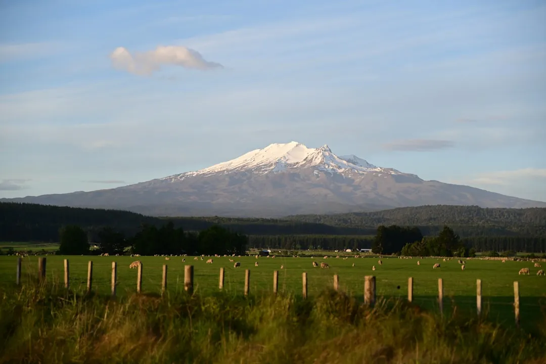
Mount Taranaki, also known as Mount Egmont, is a dormant stratovolcano that dominates the landscape of the Taranaki region on New Zealand's North Island. Rising 2,518 metres above sea level, its near-perfect symmetrical cone is often compared to Japan's Mount Fuji. The Summit Route is the ultimate challenge for hikers visiting Egmont National Park, offering a gruelling but immensely rewarding ascent that transitions from lush rainforest to alpine herb fields, and finally to a stark, volcanic moonscape. This is not a casual stroll; it is a serious mountain expedition that demands respect, physical fortitude, and keen attention to the ever-changing weather conditions of the Tasman Sea. For those who reach the top, the reward is a 360-degree panorama that stretches from the central North Island volcanoes of Tongariro, Ngauruhoe, and Ruapehu to the sparkling coastline of the Taranaki bight.
- Distance: 12.6 km return
- Elevation Gain: 1,568 m
- Duration: 8–10 hours return
- Season: December–April (summer months only for hikers; winter requires mountaineering expertise)
- Difficulty: Very Challenging (steep gradients, unstable scoria, and rock scrambling)
- Highest point: 2,518 m (Summit)
- Closest City: New Plymouth (45-minute drive)
- Trailhead: North Egmont Visitor Centre
Overview
The Mount Taranaki Summit Route is widely considered one of the most demanding day hikes in New Zealand. Unlike the gradual inclines of many Great Walks, Taranaki presents a relentless vertical challenge from the moment you leave the North Egmont Visitor Centre. The track gains over 1,500 metres of elevation in just over 6 kilometres, a ratio that tests the cardiovascular endurance of even the fittest hikers. The terrain is the primary adversary here; the middle section of the climb consists of "scoria"—loose volcanic gravel that creates a "two steps forward, one step back" experience. This section is mentally and physically taxing, requiring patience and steady footwork to navigate the shifting slopes.
Geologically, Mount Taranaki is a young volcano, with its last major eruption occurring around 1755. This youth is evident in the raw, jagged nature of the upper slopes. As you ascend, the vegetation changes dramatically. You begin in the "Goblin Forest," where twisted Kamahi trees are draped in hanging mosses and liverworts. This gives way to sub-alpine scrub and eventually to the alpine zone, where only the hardiest lichens and mosses survive. The final third of the climb involves a scramble over "The Lizard," a prominent rocky rib that provides a more stable, albeit steeper, path toward the crater. The crater itself is often filled with snow and ice year-round, providing a dramatic entrance to the final summit peak.
The mountain's isolation on the western edge of the North Island means it acts as a massive weather magnet. Clouds can form around the peak in minutes, even on a seemingly clear day. This "Taranaki Effect" can drop visibility to near zero and cause temperatures to plummet, turning a summer hike into a survival situation. However, on a clear day, the isolation is the mountain's greatest asset. Standing on the summit, you feel as though you are on the edge of the world, with the vast expanse of the Tasman Sea to the west and the rugged interior of the North Island to the east. It is a spiritual and physical pinnacle for many New Zealanders and international visitors alike.
History and Cultural Context
To the Māori people, particularly the iwi (tribes) of Taranaki, the mountain is much more than a geological feature; it is an ancestor, a living presence, and a sacred site. According to legend, Taranaki once lived in the centre of the North Island with the other great mountains: Tongariro, Ngauruhoe, and Ruapehu. A fierce battle erupted between Taranaki and Tongariro over the beautiful Mount Pihanga. Taranaki was defeated and fled toward the setting sun, carving out the path of the Whanganui River as he moved west. He eventually stopped at the coast, where he remains today, often hiding his face in clouds as he mourns his lost love and his exile from the central plateau.
Because of this sacred status, the summit is considered "tapu" (sacred). Traditionally, Māori did not climb to the very highest point out of respect for the ancestor. While the Department of Conservation (DOC) allows hikers to reach the summit, visitors are asked to respect this cultural significance by not standing directly on the very highest rock at the peak and by treating the entire mountain with the reverence it deserves. In 2017, a landmark legal agreement was reached between the Crown and the eight iwi of Taranaki, granting the mountain legal personality—a status that recognises the mountain as a living entity with its own rights, similar to the status granted to the Whanganui River.
European history on the mountain began with Captain James Cook, who sighted the peak in 1770 and named it Mount Egmont after the Earl of Egmont. The first recorded European ascent was made by Ernst Dieffenbach and James Heberley in 1839. During the New Zealand Wars of the 1860s, the mountain and its surrounding forests served as a stronghold and refuge for Māori forces. The establishment of Egmont National Park in 1900—New Zealand's second national park—marked the beginning of the mountain's era as a premier destination for recreation and conservation. Today, the name Mount Taranaki is the primary official name, though "Mount Egmont" remains as an official secondary name for the peak.
Want more background? Read extended notes on history and cultural context → Learn more
Seasonal Highlights and Weather Reality
The window for a safe "hiking" ascent of Mount Taranaki is remarkably narrow. From December to April, the route is typically clear of major snow and ice, allowing fit hikers with standard equipment to reach the summit. During these summer months, the alpine flowers are in bloom, and the long daylight hours provide a necessary safety margin for the 8–10 hour journey. However, even in mid-summer, the summit temperature can be near freezing, and sudden storms can bring sleet or snow to the upper slopes.
Autumn (March and April) is often considered the best time to climb. The weather patterns tend to be more stable, and the summer crowds have thinned. The air is often crisper, providing exceptional clarity for the views across to the South Island's Marlborough Sounds and the central North Island volcanoes. However, the days are shorter, meaning an early start (before 7:00 AM) is non-negotiable to ensure a return before dark.
From May to November, Mount Taranaki is a different beast entirely. The mountain becomes a serious alpine environment covered in snow and ice. During this period, the Summit Route is strictly for experienced mountaineers. The "Lizard" and the scoria slopes become treacherous sheets of ice, and the risk of avalanches is real. Hikers without ice axes, crampons, and the technical knowledge to use them should not attempt the summit in winter. Many accidents on Taranaki occur when ill-equipped visitors attempt to push past the snow line in late spring or early winter, unaware of how quickly the terrain becomes lethal.
Regardless of the season, the "Taranaki Effect" is the most important weather factor. The mountain creates its own microclimate. It is common for New Plymouth to be bathed in sunshine while the mountain is lashed by gale-force winds and torrential rain. Always check the high-altitude forecast, not just the local town forecast, before setting out.
Recommended Itinerary
Route Progression: North Egmont to Summit
Stage 1: North Egmont Visitor Centre to Tahurangi Lodge
- Distance: 4.5 km
- Elevation Gain: 550 m
- Time: 1.5–2 hours
- The journey begins at the North Egmont Visitor Centre (940 m).
- Follow the boardwalk and gravel track through the "Goblin Forest."
- The gradient is steady but manageable as you wind up the lower slopes.
- Pass the Camphouse and continue onto the 4WD service road.
- Arrive at Tahurangi Lodge (1,492 m), a private alpine club hut. This is the last point with any shelter and the last place to find a toilet.
- Take a moment here to assess the weather; if the clouds are lowering or winds are picking up, this is the best place to turn back.
Stage 2: The Puffer and the Scoria Slopes
- Distance: 1.2 km
- Elevation Gain: 500 m
- Time: 1.5–2 hours
- Immediately above Tahurangi Lodge, the track hits "The Puffer," a steep, stepped section that earns its name quickly.
- The vegetation disappears, replaced by the infamous scoria slopes.
- This is the most physically and mentally draining part of the climb. The ground is loose volcanic gravel.
- Follow the orange marker poles closely. The track zigzags to mitigate the steepness, but it remains a slog.
- Focus on steady breathing and small steps to avoid burning out your calves.
Stage 3: The Lizard and the Crater
- Distance: 0.6 km
- Elevation Gain: 400 m
- Time: 1–1.5 hours
- At the top of the scoria, you reach "The Lizard," a prominent rocky ridge.
- The terrain changes from loose gravel to solid rock scrambling. You will need to use your hands in several places.
- The route is steep and exposed; those with a fear of heights may find this section challenging.
- The Lizard leads you directly into the crater. In summer, the crater may contain a small amount of snow or a frozen tarn.
- The atmosphere here is eerie and silent, a stark contrast to the wind-whipped slopes below.
Stage 4: The Final Summit Push
- Distance: 0.3 km
- Elevation Gain: 100 m
- Time: 20–30 minutes
- Cross the crater floor toward the final peak on the opposite side.
- A short, steep scramble over rocky outcrops brings you to the summit (2,518 m).
- Respect the cultural tapu by not standing on the very highest point of the summit rock.
- Enjoy the views of the Tasman Sea, the Pouakai Ranges, and the distant peaks of Tongariro National Park.
Stage 5: The Descent
- Time: 3–4 hours
- The descent is often harder on the joints than the ascent.
- Be extremely careful on the scoria slopes; it is easy to lose your footing and slide.
- The "Lizard" requires careful down-climbing.
- Once back at Tahurangi Lodge, the final walk down the 4WD road and through the forest feels long but is technically easy.
- Ensure you check back in at the Visitor Centre or notify your emergency contact once you are safely down.
Planning and Bookings
Book Your Trip
Everything you need to plan your journey
Accommodation
Find places to stay near New Plymouth
Flights
Search flights to New Plymouth
Essential Preparation
Preparation for Mount Taranaki begins with physical conditioning. You should be comfortable with 8–10 hours of strenuous activity and have experience with steep, uneven terrain. This is not a suitable first-time hike for those without a baseline level of mountain fitness. Beyond fitness, timing is everything. You must monitor the weather forecasts for several days leading up to your attempt. The MetService "Mountains" forecast for Egmont National Park is the only reliable source; do not rely on the New Plymouth city forecast.
Logistically, New Plymouth is the best base. It is a vibrant coastal city with plenty of supermarkets, outdoor gear stores, and accommodation options. From New Plymouth, it is a 45-minute drive to the North Egmont Visitor Centre. There are no public buses to the trailhead, so you will need a rental car or to arrange a private shuttle. Ensure your vehicle has enough fuel, as there are no petrol stations once you enter the park boundaries. It is also essential to leave your intentions with a trusted contact or use the intentions book at the Visitor Centre.
Trail Accommodation
The Mount Taranaki Summit Route is designed as a day hike, and there is no public accommodation on the route itself. However, there are options at the trailhead and nearby for those who want an early start.
Trailhead Accommodation:
- The Camphouse (North Egmont): Located right at the trailhead, this historic building offers bunk-style accommodation with a shared kitchen and bathroom. It must be booked through the DOC website. It is ideal for those wanting to start the climb at dawn.
- North Egmont Visitor Centre: While you cannot sleep in the centre, it provides essential information, maps, and a small café.
On-Route Accommodation:
- Tahurangi Lodge: This is a private lodge owned by the Taranaki Alpine Club. It is generally not available for public bookings unless you are a member or part of an organised club trip. It serves as an emergency shelter only for the general public.
- Camping: Camping is not permitted on the Summit Route or in the alpine zone above the bush line to protect the fragile environment and respect the cultural significance of the mountain.
Nearby Options:
- There are various lodges and campsites in the lower reaches of Egmont National Park, such as the Konini Lodge at Dawson Falls (a 45-minute drive from North Egmont).
Required Gear
- Sturdy Hiking Boots: Essential. The scoria is sharp and abrasive; lightweight sneakers will be destroyed and offer no ankle support on the shifting slopes.
- Layered Clothing: Use the layering system (merino or synthetic base layer, fleece mid-layer, and a windproof/waterproof outer shell). Avoid cotton, which stays cold and heavy when wet.
- Waterproof Jacket: High-quality Gore-Tex or similar with a hood. The wind on the Lizard can be piercing.
- Gloves and Beanie: Even in summer, the summit temperature is significantly lower than the trailhead. You will also want gloves to protect your hands while scrambling on the rocks.
- Sun Protection: High SPF sunscreen, lip balm, and sunglasses. The UV radiation at 2,500 metres is extreme, and the reflection off the rocks (or snow in the crater) can cause rapid burning.
- Head Torch: With spare batteries. If your descent takes longer than expected, you do not want to be navigating the forest in the dark.
- First Aid Kit: Including blister plasters, antiseptic wipes, and any personal medications.
What to Bring
- Water: Minimum 3 litres per person. There is NO drinkable water on the track above the Visitor Centre. Do not rely on Tahurangi Lodge for water.
- High-Energy Food: Pack more than you think you need. Include a mix of slow-release energy (sandwiches, nuts) and quick-hit sugars (chocolate, energy gels) for the final push.
- Emergency Shelter: A lightweight foil bivy bag or space blanket.
- Mobile Phone and Power Bank: Signal is available on much of the upper mountain but is patchy in the forest.
- Personal Locator Beacon (PLB): Highly recommended. These can be hired from the North Egmont Visitor Centre or outdoor stores in New Plymouth.
- Rubbish Bag: To carry out all your waste, including fruit peels and tissues.
Permits
Currently, no permits or fees are required to hike the Mount Taranaki Summit Route. Access to Egmont National Park is free for all visitors. However, this lack of a formal permit system does not mean the mountain is "open" at all times. The Department of Conservation may issue alerts or "strongly discourage" climbing during periods of extreme weather or high avalanche risk.
Registration and Safety:
- While not a permit, it is standard practice to sign the intentions book at the North Egmont Visitor Centre before you start and sign back in when you return. This is the first place Search and Rescue will look if you are reported missing.
- If you are climbing in a large organised group (over 10 people), it is polite to notify the Visitor Centre in advance to ensure the track isn't overcrowded.
Future Changes:
- With the mountain's new legal status and increasing visitor numbers, there have been discussions about introducing a booking system or a "cultural fee" to support the maintenance of the track and the protection of the mountain's heritage. Always check the official DOC website for the most up-to-date information before your trip.
Parking:
- Parking at the North Egmont Visitor Centre is free but can fill up very quickly on summer weekends. Arriving before 7:30 AM is recommended to secure a spot close to the trailhead.
Other Activities in the Area
If the weather prevents a summit attempt, or if you have extra days in the region, Taranaki offers a wealth of other outdoor experiences:
- The Pouakai Crossing: Often described as Taranaki's version of the Tongariro Alpine Crossing. This 19 km one-way hike takes you across the Pouakai Ranges, offering the famous "reflection lake" view of the mountain. It is less vertical than the summit but equally beautiful.
- Dawson Falls: Located on the southern side of the mountain, this area features beautiful waterfalls, the "Wilkies Pools" (natural rock slides), and a different perspective of the peak.
- New Plymouth Coastal Walkway: An award-winning 12.7 km path that winds along the city's edge, featuring the iconic Te Rewa Rewa Bridge which frames the mountain perfectly.
- Govett-Brewster Art Gallery / Len Lye Centre: A world-class contemporary art museum in New Plymouth, famous for its shimmering stainless steel exterior and kinetic sculptures.
- Pukekura Park: One of New Zealand's premier botanical gardens, located in the heart of New Plymouth. It is particularly spectacular during the Festival of Lights in summer.
- Surfing the 45-Degree Highway: State Highway 45 (Surf Highway 45) circles the coast of Taranaki, offering some of the best and most consistent surf breaks in the country.
Safety and Conditions
Mount Taranaki has a reputation as one of New Zealand's deadliest mountains. This is not because the climb is technically impossible, but because its accessibility lures unprepared hikers into a high-alpine environment. The most common causes of accidents are hypothermia, falls on slippery terrain, and becoming lost in cloud.
The Weather Rule: If you cannot see the summit from the Visitor Centre, or if there is a thick cap of cloud on the mountain, reconsider your climb. If the wind is strong enough to buffeted you at Tahurangi Lodge, it will be dangerously powerful on the Lizard. There is no shame in turning back; the mountain will be there another day.
The "Summit is Halfway" Mentality: Many hikers exhaust themselves reaching the top, forgetting that the descent is equally demanding. The scoria slopes are notorious for causing "jelly legs," which leads to stumbles and twisted ankles. Save at least 40% of your energy and water for the trip back down.
Icing and Snow: Even in summer, the crater can be icy. If you encounter ice that you cannot safely walk across without sliding, do not attempt to cross it. A slip in the crater or on the upper slopes can result in a long, uncontrolled slide into rocks.
Emergency Procedures: If you become lost in the cloud, stay where you are. If you are on the marked route, stay by a marker pole. Use your whistle or PLB. Do not attempt to "shortcut" down the mountain, as many of the gullies end in sheer cliffs (bluffs) that are not visible from above.
Side Trips and Points of Interest
Dieffenbach Cliffs: A short detour from the main track near Tahurangi Lodge leads to these impressive volcanic cliffs. They are named after the first European to climb the mountain and offer a great spot for photography and a different geological perspective of the mountain's layers.
The Red Crater: Not to be confused with the one in Tongariro, Taranaki has its own reddish volcanic features near the summit that showcase the iron-rich minerals in the lava. The contrast between the red rock, the grey scoria, and the white snow in the crater is striking.
Humphries Castle: A prominent rock formation on the northern side of the mountain, accessible via a slightly different route from Tahurangi Lodge. It is a popular spot for rock climbers but offers a dramatic viewpoint for hikers as well.
The Goblin Forest: While you walk through this on the way up, it is worth slowing down on the way back to appreciate the biodiversity. The twisted Kamahi trees and the sheer density of mosses create a prehistoric atmosphere that is unique to the wet, western slopes of Taranaki.
Leave No Trace
As a sacred site and a National Park, Mount Taranaki requires the highest standard of environmental care. The alpine environment is extremely fragile; plants that grow only a few millimetres a year can be destroyed by a single misplaced footstep.
Leave No Trace Principles:
- Plan Ahead and Prepare: Ensure you have the skills and gear to avoid needing rescue, which puts others at risk and impacts the environment.
- Travel on Durable Surfaces: Stay on the marked track and the rocky ribs of the Lizard. Avoid trampling the delicate alpine herb fields.
- Dispose of Waste Properly: Carry out ALL rubbish. This includes organic waste like banana skins or apple cores, which do not decompose quickly in the cold alpine air and can attract pests.
- Leave What You Find: Do not take rocks or plants. Respect the cultural tapu by not disturbing the summit area.
- Respect Wildlife: You may see the North Island Robin (Toutouwai) or the occasional Kea. Do not feed them.
- Be Considerate of Others: Keep noise levels down and yield to uphill hikers.
Kauri Dieback: While Kauri trees are not found on the upper slopes, they are present in the wider Taranaki region. Always use the shoe-cleaning stations at the trailhead to prevent the spread of soil-borne diseases that threaten New Zealand's native forests.