Mount Tallac Trail - The Crown Jewel of Lake Tahoe
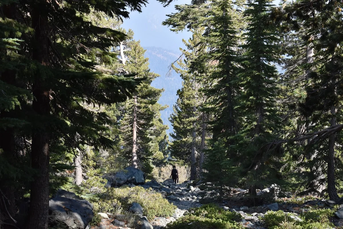
The Mount Tallac Trail is arguably the most iconic day hike in the Lake Tahoe Basin, offering a challenging 15.3 km return journey to the highest peak on the lake's immediate shoreline. Rising to an elevation of 2,968 metres, the summit provides a staggering 360-degree panorama that encompasses the deep cobalt waters of Lake Tahoe, the jagged granite spires of the Desolation Wilderness, and the shimmering alpine tarns of Fallen Leaf and Cascade Lakes. This is not merely a walk; it is a vertical pilgrimage through diverse ecological zones, transitioning from shaded forests of Jeffrey pine and white fir to sun-drenched manzanita slopes, and finally into the rugged, sub-alpine rock fields that define the High Sierra. For hikers visiting Northern California, Mount Tallac represents the ultimate test of fitness and the ultimate reward in visual splendour.
- Distance: 15.3 km return
- Elevation Gain: 1036 m
- Duration: 5–7 hours
- Difficulty: Challenging
- Best Time: July to September (Summer/Early Fall)
- Highest Point: 2,968 m
- Closest City: South Lake Tahoe, California
- Trailhead: Mount Tallac Trailhead, off Highway 89
Overview
Mount Tallac stands as a sentinel over the South Shore of Lake Tahoe, its distinctive profile recognisable from almost every vantage point around the lake. The trail is a masterclass in Sierra Nevada geography, beginning at an elevation of approximately 1,950 metres and climbing relentlessly until it reaches the summit. The experience is defined by its three distinct stages: the gentle forested approach, the lake-dotted mid-section, and the gruelling final ascent over volcanic rock and granite scree. Unlike many other peaks in the region that require multi-day backpacking trips to reach, Tallac offers high-alpine drama accessible within a single, albeit strenuous, day.
The terrain is notoriously varied. The initial kilometres are soft underfoot, winding through thick stands of conifers where the air is heavy with the scent of pine resin. As the elevation increases, the forest thins, replaced by the "Tallac scree"—a legendary section of loose, broken rock that tests the stability of even the most experienced hikers. The middle portion of the hike offers a brief emotional and physical reprieve as you pass Floating Island Lake and Cathedral Lake, two pristine alpine bodies of water that serve as perfect milestones. However, the final 3 kilometres are where the true challenge lies, as the trail steepens significantly, zig-zagging up the shoulder of the mountain through exposed terrain where the sun can be unforgiving.
What sets Mount Tallac apart from other regional hikes is the sheer scale of the verticality. Looking down from the summit, the boats on Lake Tahoe appear as tiny white specks on a vast blue mirror. To the west, the Desolation Wilderness stretches out in a sea of grey granite and hidden blue pockets, a landscape carved by ancient glaciers. The sense of accomplishment upon reaching the summit cairn is profound, as the 1,036 metres of vertical gain are hard-earned. This trail is a rite of passage for local residents and a "bucket list" item for international visitors seeking the quintessential California mountain experience.
History and Cultural Context
The name "Tallac" is derived from the Washoe (Wa She Shu) Native American word meaning "Great Mountain." For thousands of years, the Washoe people inhabited the Tahoe Basin during the summer months, following a seasonal migration from the high desert valleys to the west. Mount Tallac held significant spiritual and practical importance; it served as a landmark for navigation and a source of traditional medicinal plants and hunting grounds. The Washoe consider Lake Tahoe (Da ow a ga) to be the centre of their world, and the peaks surrounding it, including Tallac, are woven into their ancestral stories and heritage.
In the late 19th and early 20th centuries, the area around the base of Mount Tallac became a fashionable retreat for the wealthy elite of San Francisco and Sacramento. The Tallac Resort, established by Elias "Lucky" Baldwin in the 1880s, was located near the present-day Kiva Beach. Guests would travel by steamship across the lake to enjoy the luxury of the hotel, and the more adventurous among them would hire guides to lead them to the summit of Mount Tallac. These early excursions helped establish the peak as a premier destination for mountain recreation, long before the modern trail system was formalised.
Geologically, Mount Tallac is a fascinating anomaly. While much of the Sierra Nevada is composed of light-coloured granodiorite, the upper reaches of Tallac feature darker, metamorphic rock. This is a remnant of the "roof pendant"—ancient seafloor sediments that were pushed up and baked by the rising magma that formed the Sierra Nevada batholith millions of years ago. This geological history is visible in the dark, crumbly rock found near the summit, which contrasts sharply with the white granite of the nearby Desolation Wilderness peaks like Pyramid Peak and Mount Price.
Want more background? Read extended notes on history and cultural context → Learn more
Seasonal Highlights and Weather Reality
The window for hiking Mount Tallac is dictated entirely by the Sierra Nevada snowpack. In heavy snow years, the trail can remain buried under several metres of snow well into July. Conversely, in dry years, the trail may be accessible as early as late May. However, for the average hiker without specialised winter mountaineering equipment, the prime season is from July through September.
Summer (July–August): This is the peak season. The wildflowers—including lupine, paintbrush, and mule’s ears—erupt in the meadows near Cathedral Lake. The weather is typically stable, with clear blue skies and warm temperatures. However, hikers must be prepared for the "Sierra Sun," which is exceptionally intense at nearly 3,000 metres. Afternoon thunderstorms are a common occurrence in the high country; these can develop rapidly, bringing lightning, hail, and sudden temperature drops. It is a standard safety protocol to be off the summit and heading down by midday.
Autumn (September–October): Many locals consider this the best time to hike. The summer crowds thin out, the air is crisp and clear, and the mosquitoes that plague the lakes in early summer have vanished. The deciduous shrubs, such as mountain ash and huckleberry, turn vibrant shades of orange and red. While the days are shorter, the light is softer and better for photography. Early season snowstorms can occur as early as late September, so checking the forecast is essential.
Winter and Spring (November–June): During these months, Mount Tallac transforms into a serious mountaineering and backcountry skiing destination. The "Tallac Cross"—a cross-shaped snow feature on the mountain's face—becomes visible from the lake. Hiking the summer trail is impossible without snowshoes or crampons, and the risk of avalanches on the steep eastern faces is significant. Only those with avalanche safety training and proper winter gear should attempt the mountain during this period.
Recommended Itinerary
Mount Tallac Day Hike Progression
Early Morning: The Forested Approach (0 km – 3 km)
- Start at the Mount Tallac Trailhead (GPS: 38.9298, -120.0939) no later than 7:30 AM to secure parking and avoid the midday heat.
- The trail begins with a gentle incline through a mixed forest of Jeffrey pine, white fir, and incense cedar.
- Within the first 1.5 km, you will reach the boundary of the Desolation Wilderness. Ensure your day permit (available at the trailhead) is attached to your pack.
- Pass Floating Island Lake (2.7 km). This small, serene lake often has lily pads and provides the first clear view of the Tallac ridgeline.
- The terrain is relatively soft and easy on the joints during this section, allowing for a steady warm-up.
Mid-Morning: The Lake Basin and Initial Climb (3 km – 5.5 km)
- Continue another 1.2 km to reach Cathedral Lake (3.9 km). This is an excellent spot for a short break and to refill water (treatment required).
- After Cathedral Lake, the character of the trail changes abruptly. The "Tallac Scree" begins—a long, steep section of loose volcanic rock.
- The trail climbs out of the trees and onto an exposed ridge. The views of Fallen Leaf Lake to the east become increasingly dramatic.
- This section requires careful foot placement to avoid rolling an ankle on the shifting stones.
- Elevation gain becomes more pronounced here, and the lack of shade means temperatures will rise quickly.
Late Morning: The Summit Push (5.5 km – 7.6 km)
- The trail levels out slightly as it traverses a high alpine meadow behind the main ridge. In early summer, this area may still have snow patches.
- The final 1.5 km is a series of steep, rocky switchbacks leading to the summit plateau.
- The vegetation thins to hardy sub-alpine species and krummholz (stunted trees).
- Reach the summit of Mount Tallac (2,968 m). The 360-degree view is revealed all at once: Lake Tahoe to the east, the Crystal Range to the west, and the Carson Range to the south.
- Spend 30–45 minutes at the summit to refuel and take photographs, keeping an eye on cloud formations for potential thunderstorms.
Afternoon: The Descent (7.6 km – 15.3 km)
- Retrace your steps down the switchbacks. The descent can be harder on the knees than the ascent, particularly on the loose scree sections.
- Take your time through the rock fields between Cathedral Lake and the ridge; this is where most slips occur.
- Stop at Cathedral Lake or Floating Island Lake for a final rest and to soak your feet in the cold water.
- The final 3 km through the forest is a welcome relief from the sun.
- Aim to be back at the trailhead by 2:00 PM or 3:00 PM, leaving plenty of time for a post-hike swim in Lake Tahoe.
Important Notes:
- Total elevation gain is over 1,000 metres; do not underestimate the physical toll.
- The trail is very rocky; sturdy footwear with good grip is mandatory.
- There is no shade on the upper half of the mountain.
- Water is only available at the lakes and must be filtered.
- Cell phone reception is intermittent but generally available at the summit.
Planning and Bookings
Book Your Trip
Everything you need to plan your journey
Accommodation
Find places to stay near South Lake Tahoe
Flights
Search flights to South Lake Tahoe
Essential Preparation
Mount Tallac is a demanding hike that requires a high level of cardiovascular fitness. Before attempting this trail, hikers should be comfortable with gains of 500–700 metres on shorter trails. Because the trailhead is located at nearly 2,000 metres and the summit reaches almost 3,000 metres, altitude sickness is a genuine possibility for those travelling from sea level. It is highly recommended to spend at least 24 hours in South Lake Tahoe (elevation 1,897 m) to acclimatise before starting the hike.
Logistically, the biggest hurdle is parking. The Mount Tallac Trailhead parking lot is small and often fills up by 8:00 AM on weekends and 9:00 AM on weekdays during the summer. If the lot is full, you may have to park along Mount Tallac Road, but ensure all tyres are off the pavement to avoid being ticketed or towed. South Lake Tahoe serves as the primary base for this hike, offering everything from luxury resorts to campsites at Camp Richardson, which is located just a few kilometres from the trailhead.
Trail Accommodation
This is a day hike requiring no overnight accommodation on the trail itself. Camping is strictly prohibited on the slopes of Mount Tallac to protect the fragile sub-alpine environment. However, for those wishing to extend their journey into the Desolation Wilderness, there are numerous backcountry campsites available further west, such as at Gilmore Lake or Susie Lake.
Nearby Options:
- Camp Richardson Resort: Located 3 km from the trailhead, offering cabins, a hotel, and a large campground. Ideal for those who want to be close to the start.
- Fallen Leaf Campground: A beautiful Forest Service campground located on the shores of Fallen Leaf Lake, providing a more rustic experience.
- South Lake Tahoe Hotels: A wide range of hotels and motels are available within a 15-minute drive of the trailhead.
- Backcountry Camping: If you plan to camp in the Desolation Wilderness (beyond the immediate Tallac area), you must obtain a specific overnight permit through Recreation.gov. These are subject to a quota system and often sell out months in advance.
Required Gear
- Hiking Boots: Mid-to-high-cut boots with aggressive tread and ankle support are essential for the loose scree and rocky switchbacks.
- Navigation: A physical map of the Desolation Wilderness or a downloaded offline GPS map (such as AllTrails or Gaia GPS). While the trail is well-marked, the rock fields can be confusing in low visibility.
- Sun Protection: High-SPF sunscreen, a wide-brimmed hat, and UV-rated sunglasses. The exposure on the upper mountain is 100%.
- Layers: A moisture-wicking base layer, a lightweight fleece or "puffy" jacket, and a waterproof shell. Temperatures at the summit can be 10–15 degrees Celsius cooler than at the trailhead, and wind chill is common.
- Trekking Poles: Highly recommended for the descent to save your knees and provide stability on the shifting rocks.
- First Aid Kit: Include blister pads (moleskin), antiseptic wipes, and basic bandages.
- Headlamp: Even if you plan to be back by afternoon, always carry a light source in case of an unexpected delay.
What to Bring
- Water: Minimum 3 litres per person. The climb is strenuous and the air is dry. Do not rely on finding water above Cathedral Lake.
- Water Treatment: A lightweight filter (like a Sawyer Squeeze) or purification tablets if you plan to refill at Floating Island or Cathedral Lakes.
- High-Energy Food: Pack a substantial lunch plus snacks like nuts, dried fruit, and energy bars. You will burn a significant number of calories on the 1,000m climb.
- Electrolytes: Salt tablets or electrolyte powder to add to your water to prevent cramping in the heat.
- Permit: The free wilderness day permit (available at the trailhead) must be filled out and attached to your pack.
- Trash Bag: A small bag to pack out all your waste, including fruit peels and nut shells.
- Emergency Whistle: Often built into the chest strap of modern hiking packs.
Permits
Mount Tallac is located within the Desolation Wilderness, which is managed by the U.S. Forest Service. Permits are required for all visitors to ensure the protection of this federally protected area.
Day Use Permits:
- For day hikers, permits are free and self-issued at the trailhead.
- There is a wooden kiosk at the start of the trail with a box containing permit forms.
- You must fill out the form, tear off the "hiker's copy," and attach it to the outside of your backpack. The other half goes into the drop box.
- These permits are not subject to a quota, but they are mandatory for search and rescue purposes and to track trail usage.
Overnight Permits:
- If you intend to camp anywhere in the Desolation Wilderness, you must obtain a reserved overnight permit.
- These permits are managed via Recreation.gov.
- The wilderness is divided into zones, and there is a strict daily quota for each zone. Mount Tallac is adjacent to the "Gilmore Lake" and "Cathedral" zones.
- During the summer months, these permits are extremely popular and should be booked as soon as the window opens (typically 6 months in advance).
- A small fee per person, per night, is required for overnight permits.
Parking Fees: Currently, there is no fee to park at the Mount Tallac Trailhead lot, but this is subject to change. Always check for posted signs regarding "Adventure Passes" or other Forest Service requirements.
Other Activities in the Area
The South Shore of Lake Tahoe is a world-class destination with a vast array of activities to complement your hike:
- Swimming at Pope Beach or Baldwin Beach: After a hot day on the trail, there is nothing better than a plunge into the cold, clear waters of Lake Tahoe. These beaches are located just minutes from the trailhead.
- Kayaking to Fannette Island: Head to nearby Emerald Bay State Park and rent a kayak to paddle out to the only island in Lake Tahoe, which features the ruins of a stone "tea house."
- Mountain Biking at Mr. Toad’s Wild Ride: For those with energy left, the South Shore offers some of the best technical mountain biking in California.
- The Heavenly Gondola: For a less strenuous way to see the views, take the gondola up Heavenly Mountain Resort for sightseeing and high-altitude activities.
- Tallac Historic Site: Visit the preserved estates of the Baldwin, Pope, and Heller families to learn about the "Golden Age" of Tahoe resorts.
- Dining in South Lake Tahoe: Reward your efforts with a meal at one of the many breweries or lakeside restaurants in town.
Safety and Conditions
Altitude Awareness: The summit of Mount Tallac is nearly 3,000 metres above sea level. At this elevation, the air is significantly thinner. Symptoms of Mild Altitude Sickness (AMS) include headache, nausea, and dizziness. If you or anyone in your group experiences these symptoms, the only cure is to descend. Drink plenty of water and avoid alcohol the night before your hike.
Weather Hazards: The Sierra Nevada is famous for its "bluebird" days, but weather can turn violent with little warning. Lightning is a major threat on the exposed ridges of Tallac. If you see dark, towering cumulus clouds (anvil-shaped) forming, do not proceed to the summit. If you are already at the summit and hear thunder or see lightning, descend immediately. Avoid standing near lone trees or on high points during a storm.
Dehydration and Heat: The combination of high altitude, dry air, and intense sun makes dehydration a common issue. Many hikers underestimate how much water they need for a 1,000m climb. Carry more than you think you need and use electrolyte replacements. Heat exhaustion can occur even in moderate temperatures due to the intensity of the UV radiation.
Wildlife: The Desolation Wilderness is home to black bears. While they are generally shy, they are attracted to human food. Never leave your pack unattended, and ensure all food scraps are packed out. Rattlesnakes are occasionally spotted on the lower, sunnier sections of the trail; keep an eye on the path and never put your hands or feet where you cannot see.
The Scree Slope: The section of trail between Cathedral Lake and the ridge is composed of loose, unstable rock. This is the most common place for injuries, particularly sprained ankles and knee strains. Use trekking poles and maintain three points of contact when necessary.
Side Trips and Points of Interest
Floating Island Lake: Located at the 2.7 km mark, this lake gets its name from small masses of peat and vegetation that occasionally break free from the shoreline and "float" across the water. It is a peaceful spot surrounded by thick forest and offers a great reflection of the mountain above. It is a popular turnaround point for families or those looking for a shorter, easier walk.
Cathedral Lake: Just 1.2 km past Floating Island Lake, Cathedral Lake sits in a dramatic cirque directly beneath the towering cliffs of Mount Tallac. The water is crystal clear and often warmer than the main lake, making it a tempting spot for a quick dip. The "Cathedral" name refers to the spire-like rock formations that ring the basin.
The Tallac Cross: While best viewed from a distance (such as from the lake or Highway 89), the "cross" is a geological feature on the mountain's east face where two deep couloirs intersect. In winter and spring, these couloirs fill with snow, creating a giant white cross that is a local landmark. When hiking the trail, you will pass near the top of these couloirs.
Gilmore Lake Detour: For very fit hikers, a detour to Gilmore Lake adds about 3 km to the total distance. Instead of heading straight up the final switchbacks, you can drop down the back side of the ridge to this large, deep alpine lake. It is a popular spot for backcountry camping and offers a different perspective of the Desolation Wilderness peaks.
Leave No Trace
The Desolation Wilderness is one of the most heavily used wilderness areas in the United States. To maintain its "untrammelled" character, all visitors must strictly adhere to Leave No Trace principles. The fragile sub-alpine plants near the summit can take decades to recover from being stepped on.
Core Principles for Mount Tallac:
- Plan Ahead and Prepare: Know the regulations, carry the right gear, and check the weather.
- Travel on Durable Surfaces: Stay on the established trail. Do not cut switchbacks, as this causes severe erosion and destroys vegetation.
- Dispose of Waste Properly: Pack out all trash, including organic waste like orange peels or apple cores, which do not decompose quickly in the thin alpine soil and can harm wildlife. If you must "go" in the woods, bury human waste in a hole 15–20 cm deep at least 60 metres from water sources.
- Leave What You Find: Do not pick wildflowers or remove rocks. Leave the summit cairns as they are.
- Respect Wildlife: Observe from a distance and never feed animals.
- Be Considerate of Other Visitors: Keep noise levels down. Yield to uphill hikers, as they have the right of way.