Mount St. Helens Summer Route - Standing on the Edge of a Volcano
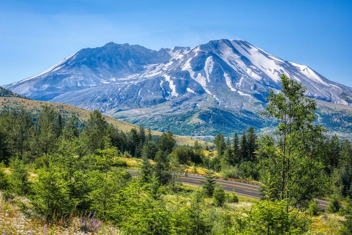
The Mount St. Helens Summer Route, primarily known as the Monitor Ridge Route, is one of the most iconic and geologically significant mountain climbs in North America. Located within the Mount St. Helens National Volcanic Monument in Washington State, this 13.7-kilometre return journey offers hikers the rare opportunity to stand on the rim of an active stratovolcano. Unlike the technical glaciated peaks of the nearby Cascade Range, such as Mount Rainier or Mount Adams, the Summer Route is a non-technical scramble. However, its accessibility should not be mistaken for ease. The trail ascends 1,371 vertical metres over a relatively short distance, traversing ancient forest, punishing boulder fields, and exhausting volcanic ash slopes.
Since the cataclysmic eruption on 18 May 1980, which removed the upper 400 metres of the mountain and fundamentally altered the surrounding landscape, Mount St. Helens has become a living laboratory for ecological recovery and geological study. Reaching the summit rim at 2,549 metres provides a staggering perspective of the 1.6-kilometre-wide crater, the growing lava dome, and the world’s youngest glacier—the Crater Glacier—which curves around the dome in a unique horseshoe shape. On a clear day, the panoramic views extend across the Pacific Northwest, encompassing the snow-capped peaks of Mount Hood, Mount Adams, and the formidable Mount Rainier. This is a journey through a landscape defined by destruction and rebirth, demanding physical resilience and deep respect for the volatile forces of nature.
- Distance: 13.7 km return
- Elevation Gain: 1,371 m
- Duration: 7–12 hours
- Highest Point: 2,549 m (Crater Rim)
- Difficulty: Challenging (Strenuous scramble)
- Season: Late June to October (Permit required year-round)
- Trailhead: Climber's Bivouac (1,140 m)
- Closest City: Woodland, WA (approx. 1 hour 15 minutes drive)
Overview
The Mount St. Helens Summer Route is a masterclass in environmental transition. The journey begins at Climber’s Bivouac, nestled at 1,140 metres within a lush, second-growth forest of Douglas fir and Western hemlock. For the first 3.5 kilometres, the Ptarmigan Trail #216A provides a deceptively gentle introduction, winding through shaded woodland where the air is cool and the ground is cushioned by pine needles. This section serves as a vital warm-up before the landscape undergoes a violent transformation at the timberline.
As you emerge from the forest at approximately 1,460 metres, the "true" climb begins. The trees give way to the Monitor Ridge, a massive spine of dacite lava flows. The middle third of the climb is dominated by the boulder fields—a vast, chaotic expanse of abrasive volcanic rock. There is no single defined path here; instead, hikers must navigate from one wooden marker post to the next, using hands and feet to scramble over rocks ranging from the size of a suitcase to the size of a small car. This section tests balance, ankle stability, and cardiovascular endurance, as the gradient steepens significantly. The rock is exceptionally sharp, composed of cooled lava that can easily tear skin or clothing, making gloves a highly recommended accessory even in the height of summer.
The final third of the ascent is perhaps the most mentally and physically taxing. Above the boulder fields, the terrain shifts to loose volcanic ash, pumice, and "scree"—small, pea-sized rocks that behave like ball bearings on a hard surface. For every two steps forward, hikers often feel they are sliding one step back. The air thins as you approach 2,500 metres, and the lack of shade makes the sun’s reflection off the light-coloured pumice intense. However, the first glimpse of the crater rim provides an unparalleled surge of adrenaline. Standing on the edge, looking down into the steaming crater where the new lava dome continues to grow, is an experience that few other hikes in the world can replicate. The scale of the 1980 blast becomes visceral as you look north across the "Blast Zone" toward Spirit Lake and the Pumice Plain, seeing exactly where the mountain once stood.
This is not a hike to be taken lightly. There is no water available on the entire route, and the weather can shift from blistering heat to freezing alpine storms within an hour. Success on Mount St. Helens requires careful planning, a high level of physical fitness, and the humility to turn back if conditions deteriorate. For those who reach the rim, the reward is a profound connection to the geological heartbeat of the planet.
History and Cultural Context
The history of Mount St. Helens is a narrative of immense geological power and deep cultural significance. To the indigenous peoples of the Pacific Northwest, particularly the Cowlitz and Klickitat tribes, the mountain is known as "Louwala-Clough," which translates to "Smoking Mountain." In their oral traditions, the mountain is often depicted as a beautiful but temperamental maiden caught in a tragic rivalry between two brothers, represented by Mount Hood (Pahto) and Mount Adams (Wyeast). These stories accurately reflect the mountain's long history of eruptive activity, which has been more frequent than any other volcano in the contiguous United States over the last 4,000 years.
The modern history of the mountain was forever changed on the morning of 18 May 1980. Following two months of earthquakes and steam-venting episodes, a magnitude 5.1 earthquake triggered the largest terrestrial landslide in recorded history. The entire north face of the mountain collapsed, releasing the pressure on the superheated magma within. The resulting lateral blast travelled at speeds of up to 1,000 kilometres per hour, levelling 600 square kilometres of ancient forest in seconds. The eruption column rose 24 kilometres into the atmosphere, depositing ash across eleven US states. The summit elevation dropped from 2,950 metres to 2,549 metres, leaving behind the massive horseshoe-shaped crater that hikers visit today.
The 1980 eruption claimed 57 lives and caused billions of dollars in damage, but it also created a unique opportunity for science. In 1982, President Ronald Reagan and Congress established the Mount St. Helens National Volcanic Monument, spanning 44,500 hectares, to allow the landscape to recover naturally with minimal human interference. Today, the Summer Route allows hikers to witness this recovery first-hand. You will see "ghost forests" of bleached, downed logs, the return of lupine and Indian paintbrush to the ash slopes, and the surprising resilience of elk and mountain goats in this rugged terrain. The mountain remains an active volcano, monitored 24/7 by the United States Geological Survey (USGS). Small earthquakes and steam plumes are common, serving as a constant reminder that the story of Mount St. Helens is far from over.
Want more background? Read extended notes on history and cultural context → Learn more
Seasonal Highlights and Weather Reality
The "Summer Route" is strictly defined by the presence of snow. While the mountain is climbed year-round, the Monitor Ridge route is the preferred path once the snow has melted off the boulder fields, typically from late June through October. Outside of this window, the mountain is covered in deep snow and ice, requiring an entirely different approach (the Worm Flows Winter Route) and advanced mountaineering skills.
Late June to July: This is the transition period. While the lower forest is clear, large snow patches often remain in the boulder fields and on the final ash slope. These can be helpful, as walking on firm snow is often easier than scrambling over loose rock, but they require traction devices (microspikes) and trekking poles. The wildflowers, particularly the purple lupine, begin to carpet the lower ridges during this time.
August: This is the peak of summer and the most popular time to climb. The route is usually entirely snow-free. However, this is also the most challenging time regarding heat. The volcanic rock absorbs and radiates heat, and there is zero shade once you leave the forest. Temperatures on the ridge can feel 10 degrees hotter than the forecast, and dehydration is a significant risk. Dust from the ash slopes can also be heavy during dry spells.
September to early October: Many experienced climbers consider this the "golden window." The temperatures are cooler, the air is often crisper, and the summer crowds begin to thin. The risk of afternoon thunderstorms—a major hazard in July and August—diminishes. However, the days are shorter, and the first autumn dustings of snow can arrive unexpectedly. If you climb in October, you must be prepared for freezing temperatures and high winds at the rim.
Weather Reality: Mount St. Helens creates its own weather. It is common for the trailhead to be in bright sunshine while the summit is shrouded in "lenticular" clouds or battered by 60 km/h winds. Conversely, a "marine layer" of clouds often blankets the valleys, leaving the summit in the sun—a phenomenon known as an inversion. Always check the mountain-specific forecast (Point Forecast) rather than the forecast for the nearest town, as conditions at 2,500 metres are vastly different from those at sea level.
Recommended Itinerary
Mount St. Helens Summer Route Progression
Stage 1: The Forest Ascent (Climber's Bivouac to Timberline)
- Distance: 3.5 km
- Elevation Gain: 320 m
- Time: 1–1.5 hours
- Start at the Ptarmigan Trailhead at the northern end of the Climber's Bivouac parking area.
- The trail is well-maintained, wide, and winds through a beautiful canopy of evergreen trees.
- This is the only shaded portion of the hike; use this time to find a steady rhythm.
- Pass the junction with the Loowit Trail (which circles the entire mountain).
- Reach the permit check-in station at the edge of the trees. Ensure your permit is displayed on your pack.
- Take a final break in the shade and apply sunscreen before emerging onto the ridge.
Stage 2: The Boulder Fields (Monitor Ridge)
- Distance: 2.5 km
- Elevation Gain: 600 m
- Time: 2–3 hours
- The terrain shifts abruptly from dirt path to massive dacite lava blocks.
- Follow the large wooden posts (approx. 2 metres tall) that mark the general route.
- Expect significant "hands-on" scrambling. Test every rock before committing your weight, as some large boulders can be unstable.
- The abrasive nature of the rock will wear down boot soles and skin; this is where gloves are essential.
- Look back frequently to enjoy the expanding views of Mount Hood and the Yale Lake reservoir.
- This section is the most physically demanding for the legs and core due to the constant high-stepping.
Stage 3: The Ash Slope (The Final Push)
- Distance: 0.85 km
- Elevation Gain: 451 m
- Time: 1.5–2.5 hours
- The boulders give way to a steep, unrelenting slope of fine volcanic ash and pumice.
- The gradient increases to nearly 35 degrees in some sections.
- Use trekking poles to maintain balance and provide extra upward thrust.
- The "two steps forward, one step back" effect is most pronounced here. Look for firmer ground near larger rock outcrops if available.
- The air becomes noticeably thinner; take frequent "micro-breaks" (30 seconds) to keep your heart rate manageable.
- The false summits can be discouraging—keep your eyes on the next marker post.
Stage 4: The Crater Rim and Summit
- Distance: Exploration along the rim
- Elevation: 2,549 m
- Time: 30–60 minutes (weather permitting)
- The ground flattens as you reach the rim. The view into the crater is sudden and breathtaking.
- Observe the lava dome, the steaming fumaroles, and the Crater Glacier.
- The "True Summit" is a short walk to the west (left) along the rim.
- CRITICAL SAFETY: Stay at least 10 metres back from the edge. The rim is often composed of overhanging snow cornices or unstable ash that can collapse without warning.
- Enjoy a well-earned lunch, but keep a close eye on the time and weather.
Stage 5: The Descent
- Distance: 6.85 km
- Elevation Loss: 1,371 m
- Time: 3–5 hours
- Descending the ash slope is much faster than ascending—many hikers "plunge step" through the soft pumice.
- Be extremely careful in the boulder fields; tired legs are prone to stumbles and ankle sprains.
- The descent is often harder on the knees than the ascent; use your poles for support.
- Once back in the forest, the final 3.5 km is a gentle stroll back to the bivouac.
- Sign out at the trailhead register if one is provided.
Important Notes:
- Total moving time varies wildly based on fitness; allow a full day (10–12 hours) to be safe.
- There is NO water on the trail. Carry a minimum of 3–4 litres per person.
- The trail is entirely exposed to the sun once you leave the forest.
- Cell service is spotty but often available on the ridge and at the summit.
Planning and Bookings
Book Your Trip
Everything you need to plan your journey
Accommodation
Find places to stay near Woodland
Flights
Search flights to Woodland
Essential Preparation
Preparation for Mount St. Helens begins months before you set foot on the trail. The primary hurdle is securing a climbing permit, which is mandatory year-round for anyone travelling above 1,460 metres (the timberline). Because the number of climbers is strictly limited to protect the fragile volcanic environment and ensure safety, permits for summer weekends often sell out within minutes of being released.
Physical preparation is equally vital. This is not a "walk in the park." You should be comfortable with steep elevation gains and have experience moving over uneven, rocky terrain. Training on stairs or steep local hills with a weighted pack is highly recommended. Logistically, the closest major city is Portland, Oregon (PDX Airport), which is approximately a 1.5 to 2-hour drive from the trailhead. The town of Woodland, Washington, serves as the final stop for fuel, groceries, and supplies. Ensure your vehicle can handle the NF-83 and NF-830 forest roads; while usually passable for sedans, they can be riddled with deep potholes and washboard sections.
Trail Accommodation
The Mount St. Helens Summer Route is designed as a day hike, and no overnight camping is permitted on the mountain itself above the timberline. However, staying near the trailhead the night before is highly recommended to allow for an early start (typically 5:00 AM to 7:00 AM).
Climber's Bivouac (Trailhead):
- The most convenient option. It offers primitive campsites located directly at the trailhead.
- Facilities: Vault toilets and several designated tent pads/parking spots.
- Water: NO WATER is available at the bivouac. You must bring all the water you need for camping and for the climb.
- Cost: A Northwest Forest Pass or a Digital Day Pass is required for parking (approx. $5 USD per day).
- Availability: First-come, first-served. It fills up quickly on Friday and Saturday nights in summer.
Nearby Alternatives:
- Cougar, WA: A small town about 45 minutes from the trailhead. It offers several private campgrounds, a small motel, and basic cabins.
- Ape Canyon/Lava Canyon: Other nearby trailheads have small USFS campgrounds (e.g., Kalama Horse Camp) that may have more availability.
- Woodland, WA: Offers standard hotel and motel options for those who prefer a bed and a shower before the climb.
Required Gear
- Sturdy Hiking Boots: Must have deep tread and good ankle support. The volcanic rock will shred lightweight trainers or sandals.
- Climbing Gloves: Inexpensive leather work gloves or gardening gloves are perfect. They protect your hands from the razor-sharp dacite boulders during the scramble.
- Trekking Poles: Essential for the ash slope and for saving your knees on the 1,371-metre descent.
- Gaiters: Short "scree" gaiters are highly recommended to keep volcanic ash and small rocks out of your boots.
- Sun Protection: High-SPF sunscreen, lip balm with SPF, and a wide-brimmed hat. The reflection off the pumice is intense.
- Navigation: A printed map and compass, or a GPS/offline map app (like Gaia GPS or AllTrails). While the route is marked with poles, clouds can reduce visibility to near zero.
- Headlamp: Essential for early morning starts or if the descent takes longer than planned. Bring spare batteries.
- First Aid Kit: Include blister treatment (moleskin/Leukotape), antiseptic wipes, and ibuprofen.
What to Bring
- Water: 3 to 4 litres per person. This is non-negotiable. There are no streams or springs on the route. Electrolyte powders are highly recommended to prevent cramping.
- High-Energy Food: Pack more than you think you need. Salty snacks, energy gels, nuts, and a substantial lunch for the summit. You will burn 3,000–5,000 calories on this climb.
- Layers: Even if it is 30°C in the valley, the summit can be near freezing with wind chill. Bring a moisture-wicking base layer, a fleece or "puffy" mid-layer, and a windproof/waterproof shell.
- Emergency Shelter: A lightweight emergency bivvy or space blanket.
- Permit and ID: You must carry a printed copy of your climbing permit and a valid photo ID. Rangers do patrol the mountain and will check.
- Waste Bags: "Blue bags" for human waste. If nature calls above the timberline, you are required to pack it out to protect the volcanic ecosystem. These are often available for free at the trailhead.
Permits
The permit system for Mount St. Helens is strictly managed by the US Forest Service to limit impact and ensure a high-quality experience. Between 1 April and 31 October, a quota system is in effect. For the peak summer season (15 May to 31 October), the number of climbers is limited to 100 per day.
How to Secure a Permit:
- Permits are released exclusively through Recreation.gov.
- The primary release usually occurs on the first day of the month for the following month (e.g., July permits are released on 1 June). Check the official USFS website for the exact release schedule, as it can change.
- Permits cost approximately $15 USD per person, plus a Recreation.gov transaction fee.
- You must specify the exact date of your climb. Permits are non-transferable to other dates.
- Pro Tip: Create your Recreation.gov account and log in five minutes before the release time. Permits for summer Saturdays often sell out in less than 60 seconds.
Cancellations and Last-Minute Options:
- If you miss the initial release, check the website daily. Cancellations are returned to the system in real-time.
- There are no "walk-up" permits available at the trailhead or ranger stations during the quota season.
Parking Permits:
- In addition to your climbing permit, you need a vehicle parking permit for Climber's Bivouac. A Northwest Forest Pass ($30/year) or a National Parks & Federal Recreational Lands Pass (America the Beautiful) is accepted. Alternatively, you can purchase a digital day pass online before you arrive.
Other Activities in the Area
The Mount St. Helens National Volcanic Monument offers a wealth of other attractions for those who have extra time or for family members who may not want to tackle the summit climb:
- Ape Cave: Located just a short drive from Climber's Bivouac, this is one of the longest continuous lava tubes in the continental United States. It offers two routes: an easy lower cave and a more challenging upper cave with rock scrambles. Note: Timed reservations are required.
- Johnston Ridge Observatory: Located on the north side of the mountain (requires a long drive around), this visitor centre offers the most dramatic views directly into the crater's "open" side. The films and exhibits detailing the 1980 eruption are world-class.
- Lava Canyon: A spectacular trail that follows the Muddy River as it plunges through a deep canyon carved into ancient lava flows. It features waterfalls and a high suspension bridge.
- Spirit Lake Highway (WA-504): A scenic drive with multiple viewpoints, including the Loowit Viewpoint and the Hummocks Trail, where you can walk among the debris from the 1980 landslide.
- Coldwater Lake: Formed by the 1980 eruption, this lake offers kayaking, fishing, and a beautiful boardwalk trail through recovering wetlands.
Safety and Conditions
The Rim Cornice: This is the most significant hazard at the summit. Throughout the summer, a large "lip" of snow and ice overhangs the crater. From the top, it looks like solid ground, but it is actually floating over a 600-metre drop. Never walk to the very edge of the snow. Stay on the visible rock or ash. Several climbers have lost their lives by falling through the cornice into the crater.
Volcanic Hazards: Mount St. Helens is an active volcano. While a major eruption is unlikely without warning, the crater frequently experiences rockfalls and small steam explosions. If you hear a loud "thunder" sound while at the rim, it is likely a rockfall inside the crater. If you notice a strong smell of sulphur (rotten eggs), it is coming from the volcanic vents; if it becomes overwhelming, descend immediately.
Dehydration and Heat Stroke: Because there is no water and no shade, heat-related illnesses are common. Monitor your companions for signs of confusion, dizziness, or lack of sweating. Drink water regularly, even if you don't feel thirsty, and use electrolytes.
Navigation in Whiteouts: Clouds can roll in with incredible speed, reducing visibility to a few metres. If you lose sight of the marker posts, stop and wait for a break in the clouds. Do not attempt to descend blindly, as you may end up in the dangerous "drainages" to the east or west of Monitor Ridge, which are prone to rockfalls and cliffs.
Glissading: In early summer, some climbers choose to "glissade" (slide on their bottoms) down the remaining snow patches. This can be dangerous if you don't have an ice axe to control your speed. Rocks can be hidden just beneath the snow surface, leading to serious injuries. Only glissade if you are experienced and the run-out is clear of rocks.
Side Trips and Points of Interest
The True Summit: Many hikers stop at the first point they reach on the rim. However, the true summit (2,549 m) is located about 500 metres to the west. The walk along the rim is spectacular but requires caution. Reaching the true summit provides a better view of the western side of the crater and the Goat Rocks area.
The Loowit Trail Junction: On your way up (or down), you will cross the Loowit Trail #216. This 45-kilometre loop circles the entire mountain. If you have extra energy on the descent, walking a kilometre or two in either direction on the Loowit offers a different perspective of the mountain's flanks and the "Pumice Plain" to the north.
Monitor Ridge Weather Station: Near the top of the boulder fields, you may see various scientific instruments used by the USGS to monitor the volcano's activity. These include GPS sensors to measure the mountain's "bulging" and seismometers to detect earthquakes. Please do not touch or disturb this vital equipment.
The "Chocolate" Waterfall: In early summer, as the snow melts, a temporary waterfall often forms in the drainage to the east of Monitor Ridge. The water is often brown with volcanic silt, giving it a unique appearance. It is best viewed from a distance, as the drainages are unstable.
Leave No Trace
Mount St. Helens is a fragile environment where the process of primary succession (life returning to barren rock) is being studied by scientists from around the world. Your actions can have a lasting impact on this delicate balance.
The Seven Principles at Mount St. Helens:
- Plan Ahead and Prepare: Ensure you have your permit, enough water, and the right gear to avoid needing rescue.
- Travel on Durable Surfaces: Stay on the marked trail in the forest and follow the marker posts on the ridge. Avoid trampling the small alpine plants that are struggling to gain a foothold in the ash.
- Dispose of Waste Properly: This is a "Pack it In, Pack it Out" area. This includes orange peels, nut shells, and especially human waste. Use the provided "Blue Bags" for solid human waste and carry them back to the trailhead for proper disposal.
- Leave What You Find: It is tempting to take a piece of pumice or a volcanic rock as a souvenir. However, it is illegal to remove any natural materials from the National Volcanic Monument. Take photos instead.
- Minimise Campfire Impacts: Campfires are not allowed at Climber's Bivouac or anywhere on the mountain. Use a portable stove for cooking at the trailhead.
- Respect Wildlife: You may see mountain goats, elk, or marmots. Never feed them, and maintain a distance of at least 30 metres.
- Be Considerate of Other Visitors: The climb is a significant challenge for everyone. Keep noise levels down, yield to uphill climbers, and share the summit rim space graciously.